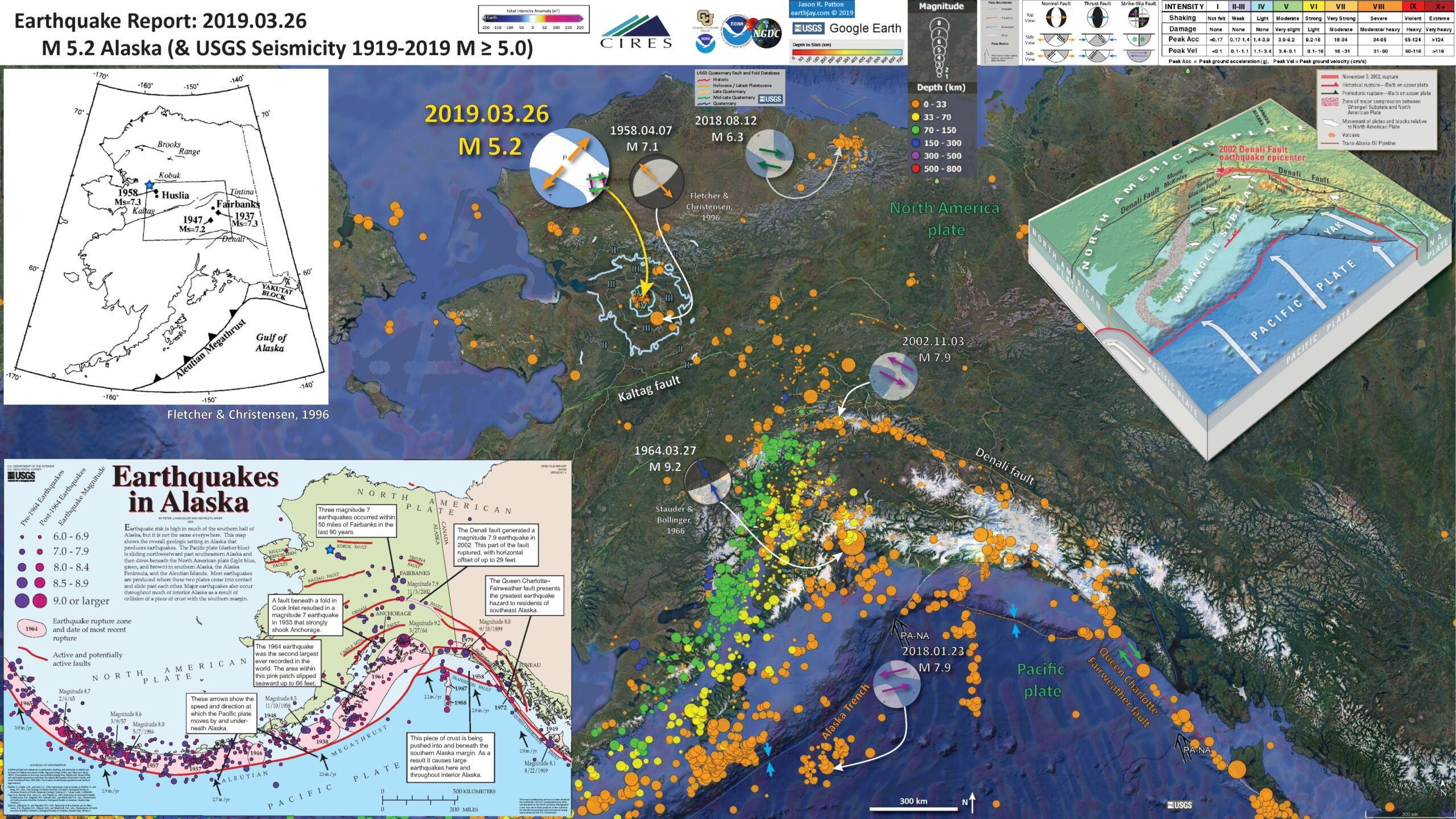
At shortly before 13:30 today in northern Alaska there was a large earthquake, with a magnitude of M=5.1 (now M 5.0).
https://earthquake.usgs.gov/earthquakes/eventpage/ak0193wxcfea/executive
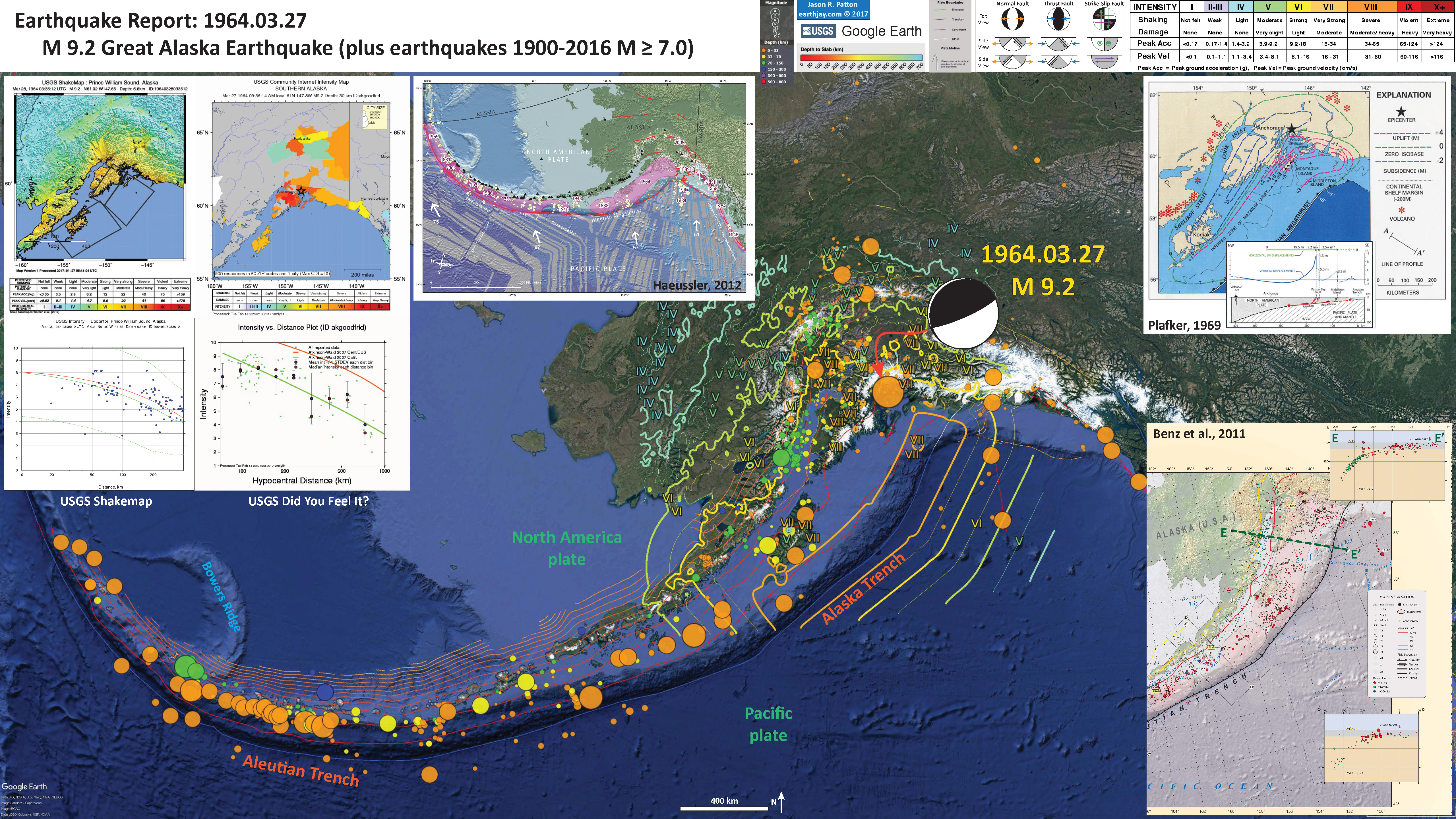
Many of us are familiar with the Good Friday earthquake, a megathrust subduction zone earthquake. This earthquake has a birthday tomorrow, from 27 March, 1964 (55 years ago).
The M=9.2 1964 temblor created a tsunami that traveled across the Pacific Ocean. More about the Good Friday earthquake and tsunami can be found here.
Alaska has a variety of major fault systems in addition to the subduction zone. There are also large strike-slip faults (move side by side) such as the Denali fault and the Kaltag fault. There are even more strike slip systems too, like the Queen Charlotte / Fairweather fault in southeastern Alaska and the Bering-Kresla shear zone in the extreme western part of the Aleutian Islands. Alaska is so cool, they even have extensional (normal) earthquakes, such as on 1 December 2018.
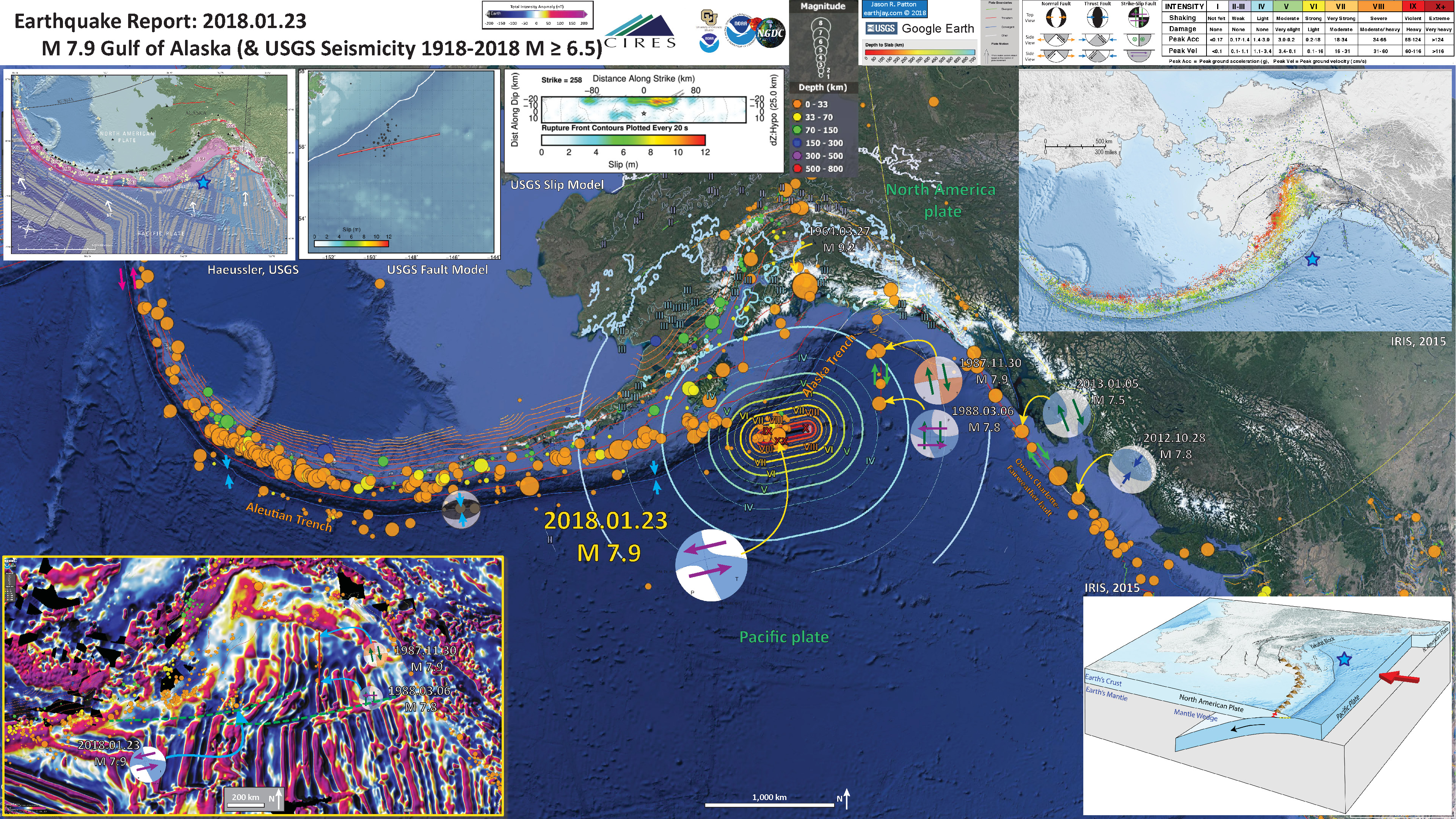
Recently, there was a series of strike-slip earthquakes in the Gulf of Alaska probably related to reactivation of pre-existing structures in the Pacific plate. We continue to have aftershocks in this area.
Also, there is an ongoing sequence of earthquakes (now, maybe it is a swarm?) in northeastern Alaska. The largest quake was in August last year (2018), with a magnitude of M=6.3.
Today’s earthquake happened away from one of the mapped faults in the USGS Quaternary Active Fault and Fold Database (the Kaltag fault). The earthquake mechanism shows this earthquake may have been a slightly oblique normal type of an earthquake. I placed strike-slip arrows on the 2 possible nodal planes.but this is mainly a normal earthquake.
There was also a normal earthquake in 1958, when a M=7.1 quake struck about 50 km (35 miles) to the southeast of today’s quake. However, the 1958 event was oriented perpendicular to today’s quake. Below are some observations made following the 1958 earthquake. There was evidence of liquefaction, with sand volcanoes about a meter thick extending for hundreds of meters laterally.
Below is my interpretive poster for this earthquake
I plot the seismicity from the past month, with color representing depth and diameter representing magnitude (see legend). I include earthquake epicenters from 1918-2018 with magnitudes M ≥ 3.0 in one version.
I plot the USGS fault plane solutions (moment tensors in blue and focal mechanisms in orange), possibly in addition to some relevant historic earthquakes.
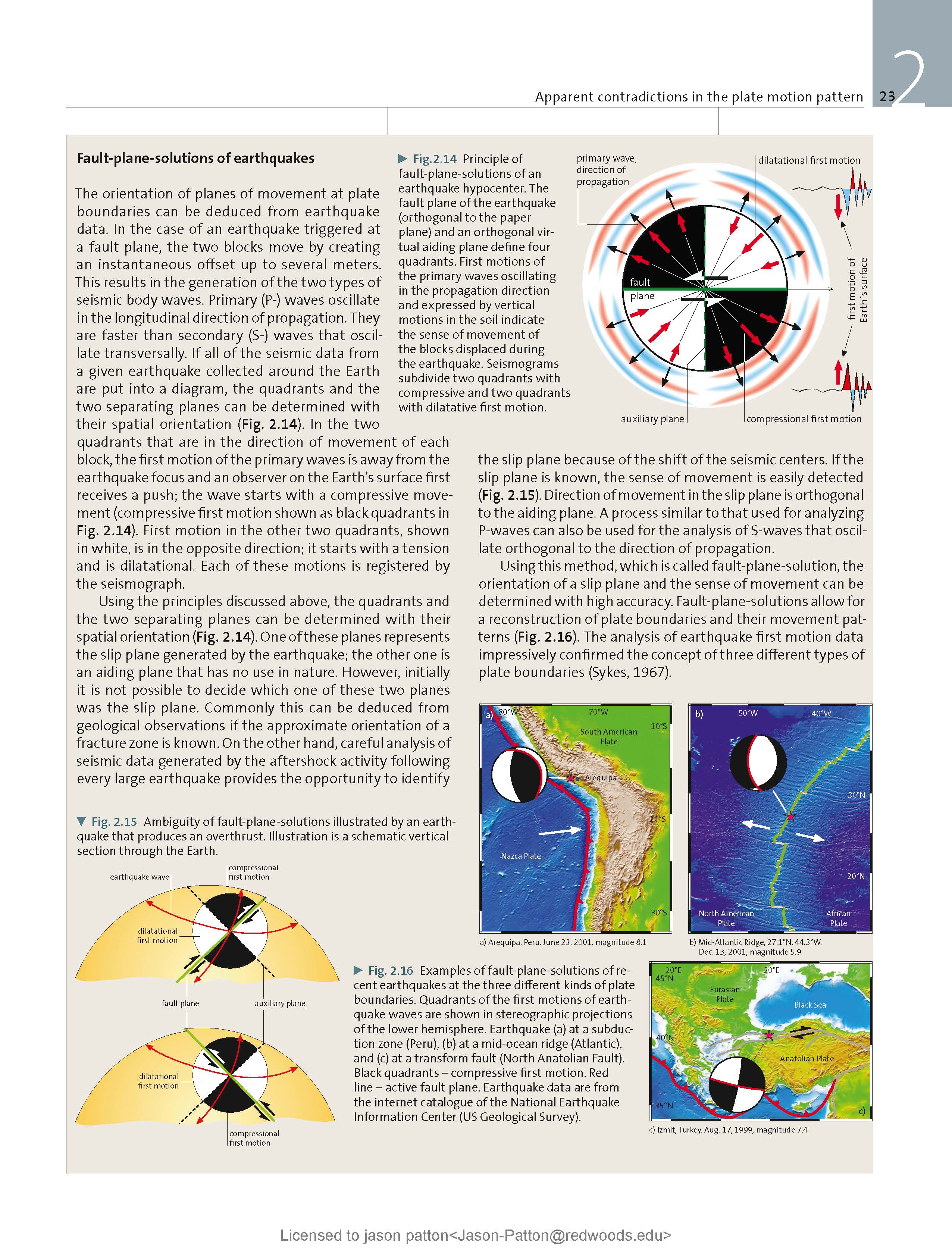
- I placed a moment tensor / focal mechanism legend on the poster. There is more material from the USGS web sites about moment tensors and focal mechanisms (the beach ball symbols). Both moment tensors and focal mechanisms are solutions to seismologic data that reveal two possible interpretations for fault orientation and sense of motion. One must use other information, like the regional tectonics, to interpret which of the two possibilities is more likely.
- I also include the shaking intensity contours on the map. These use the Modified Mercalli Intensity Scale (MMI; see the legend on the map). This is based upon a computer model estimate of ground motions, different from the “Did You Feel It?” estimate of ground motions that is actually based on real observations. The MMI is a qualitative measure of shaking intensity. More on the MMI scale can be found here and here. This is based upon a computer model estimate of ground motions, different from the “Did You Feel It?” estimate of ground motions that is actually based on real observations.
- I include the slab 2.0 contours plotted (Hayes, 2018), which are contours that represent the depth to the subduction zone fault. These are mostly based upon seismicity. The depths of the earthquakes have considerable error and do not all occur along the subduction zone faults, so these slab contours are simply the best estimate for the location of the fault.
- In the map below, I include a transparent overlay of the magnetic anomaly data from EMAG2 (Meyer et al., 2017). As oceanic crust is formed, it inherits the magnetic field at the time. At different points through time, the magnetic polarity (north vs. south) flips, the North Pole becomes the South Pole. These changes in polarity can be seen when measuring the magnetic field above oceanic plates. This is one of the fundamental evidences for plate spreading at oceanic spreading ridges (like the Gorda rise).
- Regions with magnetic fields aligned like today’s magnetic polarity are colored red in the EMAG2 data, while reversed polarity regions are colored blue. Regions of intermediate magnetic field are colored light purple.
- We can see the trends of these red and blue stripes. These lines are parallel to the ocean spreading ridges from where they were formed.
Magnetic Anomalies
- In the lower left corner is a map from the USGS that shows the major fault systems and historic earthquakes in Alaska. Note the large area in pink from the 1964 Good Friday earthquake.
- In the upper right corner is a low angle oblique figure showing the subduction zone (see the Pacific plate subduct beneath the North America plate). Some of the strike-slip faults are shown, including the location of the 2002 Denali earthquake sequence. This is from USGS Fact Sheet fs014-03 (USGS, 2003). I placed a blue star in the general location of today’s M=5.2.
- In the upper left corner is a map from Fletcher and Christensen (1966). In their paper, they describe a sequence of earthquakes in the 1950s. I placed a blue star in the general location of today’s M=5.2.
I include some inset figures. Some of the same figures are located in different places on the larger scale map below.
- Here is a poster that shows the details of the northeast Alaska sequence that started in late 2018. Here is my report that provides more details about the poster.
- Hree is the poster from the Gulf of Alaska earthquake in January 2018 and this is an update report page for this sequence.
- In commemoration of the 55th anniversary of the Good Friday earthquake and tsunami, below is the poster from my report here.
Other Report Pages
Some Relevant Discussion and Figures
- Davis (1960) includes some fantastic photo records, which some are shown below. Here is a great map showing their observations following the earthquake. Below the map is the legend and caption.
Map of a portion of the field epicenter. Alaska earthquake of 7 April 1958. (Compiled from vertical air photos and USGS Alaska Topographic Series 1:63,360, Melozitna and Kateel River Quadrangles, 1954.
- Here is the map from Davis (1960) that shows their estimate of the ground shaking intensity (using the MMI scale as described above).
Isoseismal map of the intensities of the April 7, 1958 earthquake, (Modified Mercalli scale).
- Here is a photo of one of the sand blows from Davis (1960).
Surface of one of the major sand flows covering an area greater than 1 square mile. The silty sand has a relatively uniform thickness of approximately 2½ feet.
- There was a lake in the middle of some sand dune deposits, which were overlying alluvial (river lain) sediments. Below is a photo showing some of the landsliding in the sediments and below the photo is a cross section drawing. Note the large spatial extent of this slope failure.
A conical collapse nearly 20 feet deep. It occurred approximately 200 yards from the nearest sand flow.
Cross-section A-A’ showing the arrested sand dune deposits resting on the alluvium below. Location of the cross-section is shown on the map (figure 5). [Figure 5 is the map and legend.]
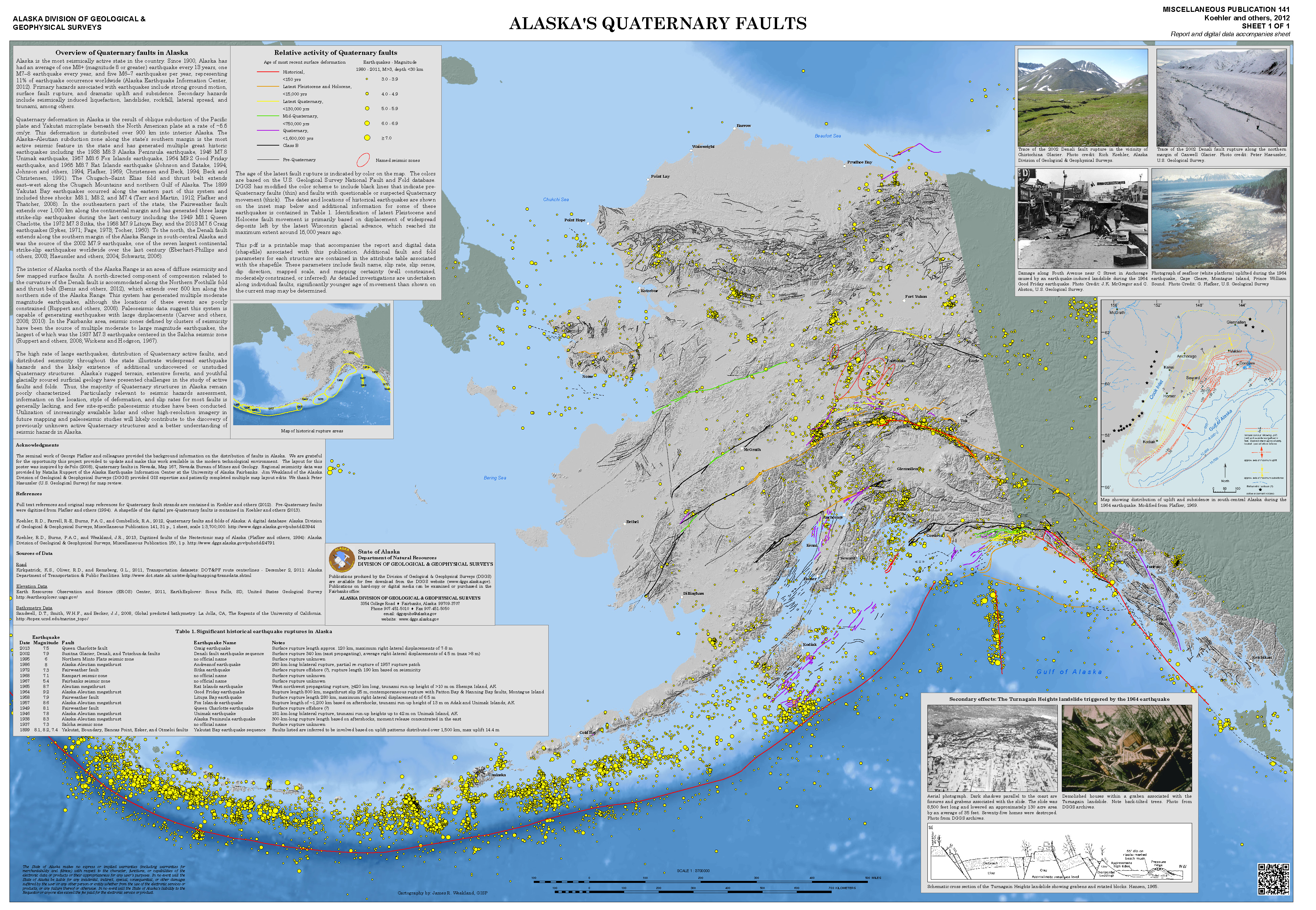
- Here is a map from Michael West at the Alaska Earthquake Center. This shows today’s earthquake in reference to the Quaternary faults and folds in Alaska: A digital database (Koehler et al., 2012). Dr. Rick Koehler is currently at the University of Nevada Reno and The Nevada Bureau of Mines and Geology. This is the map poster from Koehler et al. (2012). The link is to a 63 MB pdf file.
Geologic Fundamentals
- For more on the graphical representation of moment tensors and focal mechanisms, check this IRIS video out:
- Here is a fantastic infographic from Frisch et al. (2011). This figure shows some examples of earthquakes in different plate tectonic settings, and what their fault plane solutions are. There is a cross section showing these focal mechanisms for a thrust or reverse earthquake. The upper right corner includes my favorite figure of all time. This shows the first motion (up or down) for each of the four quadrants. This figure also shows how the amplitude of the seismic waves are greatest (generally) in the middle of the quadrant and decrease to zero at the nodal planes (the boundary of each quadrant).
- Here is another way to look at these beach balls.
The two beach balls show the stike-slip fault motions for the M6.4 (left) and M6.0 (right) earthquakes. Helena Buurman's primer on reading those symbols is here. pic.twitter.com/aWrrb8I9tj
— AK Earthquake Center (@AKearthquake) August 15, 2018
- There are three types of earthquakes, strike-slip, compressional (reverse or thrust, depending upon the dip of the fault), and extensional (normal). Here is are some animations of these three types of earthquake faults. The following three animations are from IRIS.
Strike Slip:
Compressional:
Extensional:
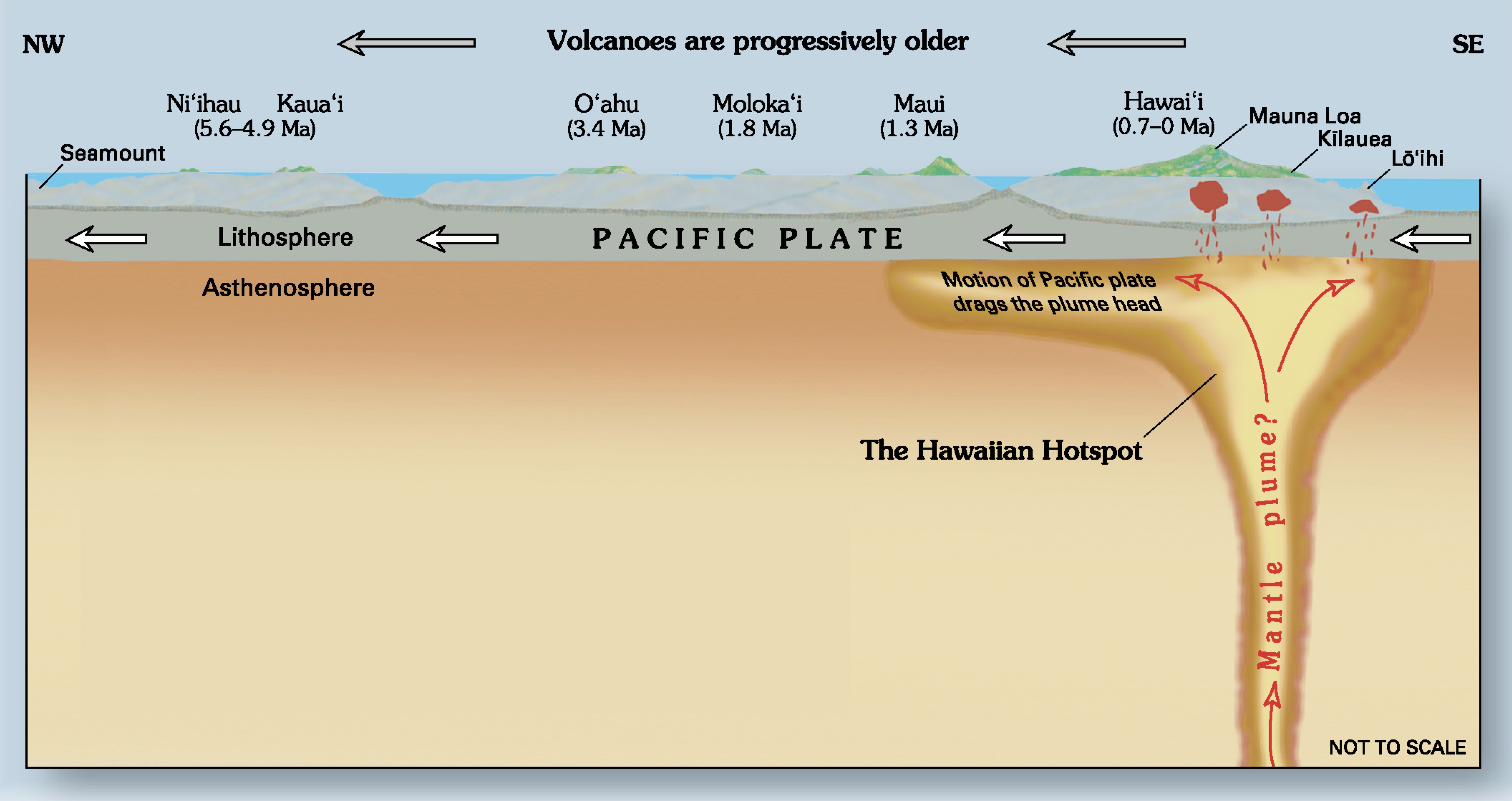
- This is an image from the USGS that shows how, when an oceanic plate moves over a hotspot, the volcanoes formed over the hotspot form a series of volcanoes that increase in age in the direction of plate motion. The presumption is that the hotspot is stable and stays in one location. Torsvik et al. (2017) use various methods to evaluate why this is a false presumption for the Hawaii Hotspot.
- Here is a map from Torsvik et al. (2017) that shows the age of volcanic rocks at different locations along the Hawaii-Emperor Seamount Chain.
- Here is a great tweet that discusses the different parts of a seismogram and how the internal structures of the Earth help control seismic waves as they propagate in the Earth.
A cutaway view along the Hawaiian island chain showing the inferred mantle plume that has fed the Hawaiian hot spot on the overriding Pacific Plate. The geologic ages of the oldest volcano on each island (Ma = millions of years ago) are progressively older to the northwest, consistent with the hot spot model for the origin of the Hawaiian Ridge-Emperor Seamount Chain. (Modified from image of Joel E. Robinson, USGS, in “This Dynamic Planet” map of Simkin and others, 2006.)
Hawaiian-Emperor Chain. White dots are the locations of radiometrically dated seamounts, atolls and islands, based on compilations of Doubrovine et al. and O’Connor et al. Features encircled with larger white circles are discussed in the text and Fig. 2. Marine gravity anomaly map is from Sandwell and Smith.
Today, on #SeismogramSaturday: what are all those strangely-named seismic phases described in seismograms from distant earthquakes? And what do they tell us about Earth’s interior? pic.twitter.com/VJ9pXJFdCy
— Jackie Caplan-Auerbach (@geophysichick) February 23, 2019
- Summary of the 1964 Earthquake
- 2019.03.26 M 5.2 Alaska
- 2018.12.20 M 7.4 Bering Kresla
- 2018.12.20 M 7.3 Bering Kresla UPDATE #1
- 2018.11.30 M 7.0 Alaska
- 2018.08.15 M 6.6 Aleutians
- 2018.08.12 M 6.4 North Alaska
- 2018.08.12 M 6.4 North Alaska UPDATE #1
- 2018.01.23 M 7.9 Gulf of Alaska
- 2018.01.23 M 7.9 Gulf of Alaska UPDATE #1
- 2018.01.23 M 7.9 Gulf of Alaska UPDATE #2
- 2017.07.17 M 7.7 Aleutians
- 2017.07.17 M 7.7 Aleutians UPDATE #1
- 2017.06.02 M 6.8 Aleutians
- 2017.05.08 M 6.2 Aleutians
- 2017.05.01 M 6.3 British Columbia
- 2017.03.29 M 6.6 Kamchatka
- 2017.03.02 M 5.5 Alaska
- 2016.09.05 M 6.3 Bering Kresla (west of Aleutians)
- 2016.04.13 M 5.7 & 6.4 Kamchatka
- 2016.04.02 M 6.2 Alaska Peninsula
- 2016.03.27 M 5.7 Aleutians
- 2016.03.12 M 6.3 Aleutians
- 2016.01.29 M 7.2 Kamchatka
- 2016.01.24 M 7.1 Alaska
- 2015.11.09 M 6.2 Aleutians
- 2015.11.02 M 5.9 Aleutians
- 2015.11.02 M 5.9 Aleutians (update)
- 2015.07.27 M 6.9 Aleutians
- 2015.05.29 M 6.7 Alaska Peninsula
- 2015.05.29 M 6.7 Alaska Peninsula (animations)
- 1964.03.27 M 9.2 Good Friday
Alaska | Kamchatka | Kurile
General Overview
Earthquake Reports
Social Media
Large earthquake strikes near Kobuk National Preserve in remote part of Alaska https://t.co/fHqOrc1nt5
— Jason "Jay" R. Patton (@patton_cascadia) March 27, 2019
- Davis, T.N., 1960. A Field Report on the Alaska Earthquakes of April 7, 1958 in BSSA, v. 50, no. 4, p. 489-510
- Fletcher, H.J. and Christensen, D.H.., 1996. A Determination of Source Properties of Large Intraplate Earthquakes in Alaska in Pageoph, v. 146, no. 1, p. 21-41
- Frisch, W., Meschede, M., Blakey, R., 2011. Plate Tectonics, Springer-Verlag, London, 213 pp.
- Hayes, G., 2018, Slab2 – A Comprehensive Subduction Zone Geometry Model: U.S. Geological Survey data release, https://doi.org/10.5066/F7PV6JNV.
- Meyer, B., Saltus, R., Chulliat, a., 2017. EMAG2: Earth Magnetic Anomaly Grid (2-arc-minute resolution) Version 3. National Centers for Environmental Information, NOAA. Model. doi:10.7289/V5H70CVX
- Meyer, B., Saltus, R., Chulliat, a., 2017. EMAG2: Earth Magnetic Anomaly Grid (2-arc-minute resolution) Version 3. National Centers for Environmental Information, NOAA. Model. https://doi.org/10.7289/V5H70CVX
- Müller, R.D., Sdrolias, M., Gaina, C. and Roest, W.R., 2008, Age spreading rates and spreading asymmetry of the world’s ocean crust in Geochemistry, Geophysics, Geosystems, 9, Q04006, https://doi.org/10.1029/2007GC001743
- Plafker, G., 1969. Tectonics of the March 27, 1964 Alaska earthquake: U.S. Geological Survey Professional Paper 543–I, 74 p., 2 sheets, scales 1:2,000,000 and 1:500,000, http://pubs.usgs.gov/pp/0543i/.
- Stauder. W. and Bollinger, G.A., 1966. The Focal Mechanism of the Alaska Earthquake of March 28, 1964, and of Its Aftershock Sequence in JGR, v. 71, no. 22, p. 5283-5296.
- USGS, 2003. Rupture in South-Central Alaska—The Denali Fault Earthquake of 2002, USGS Fact Sheet 014-03, March, 2003, https://pubs.usgs.gov/fs/2003/fs014-03/
- West, M.E., Haeussler, P.L., Ruppert, N.A., Freymueller, J.T., and the Alaska Seismic Hazards Safety Commission, 2014. Why the 1964 Great Alaska Earthquake Matters 50 Years Later in Seismological Research Letters, v. 85, no. 2, p. 1-7.
References:
Return to the Earthquake Reports page.
