UPDATES Below is a list of all the reports associated with this earthquake sequence.
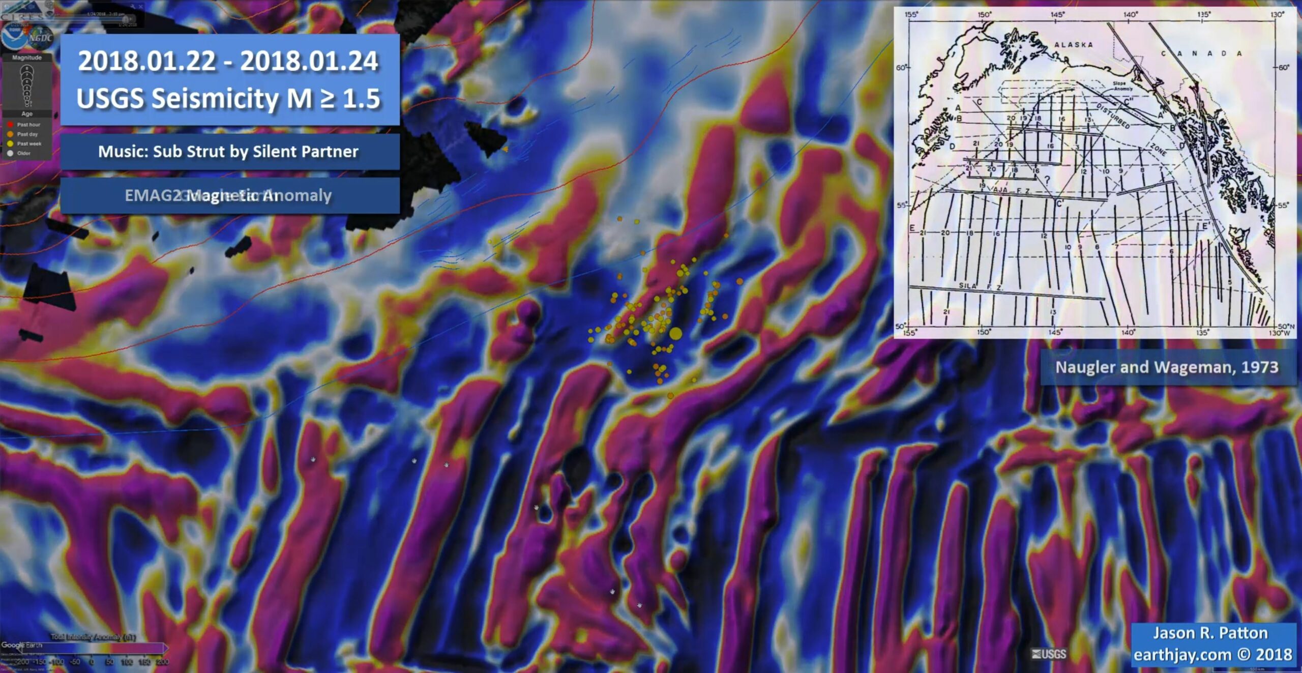
I thought it would be interesting to see the seismicity with time. Perhaps this could help us learn about the fault sources associated with this earthquake sequence.
I am not sure it worked as some issues cannot be dealt with simply with this visualization.
For example, the locations for these earthquakes may not be resolute enough [yet] to figure out the orientation of the faults at work here. The back projection data are perhaps the strongest evidence for an east-west fault. However, we still have the contradictory sense of motion along the fracture zones at the meso scale… (as revealed in the EMAG2 magnetic anomaly data).
As a reminder, if the M 7.9 earthquake fault is E-W oriented, it would be left-lateral. The offset magnetic anomalies show right-lateral offset across these fracture zones. This was perhaps the main reason why I thought that the main fault was not E-W, but N-S. After a day’s worth of aftershocks, the seismicity may reveal some north-south trends. But, as a drama student in 7th grade (1977), my drama teacher (Ms. Naichbor, rest in peace) asked our class to go stand up on stage. We all stood in a line and she mentioned that this is social behavior, that people tend to stand in lines (and to avoid doing this while on stage). Later, when in college, professors often commented about how people tend to seek linear trends in data (lines). I actually see 3-4 N-S trends and ~2 E-W trends in the seismicity data.
So, that being said, here is the animation I put together. I used the USGS query tool to get earthquakes from 1/22 until now, M ≥ 1.5. I include a couple inset maps presented in my interpretive posters. The music is copyright free. The animations run through twice.
Here is a screenshot of the 14 MB video embedded below. I encourage you to view it in full screen mode (or download it).
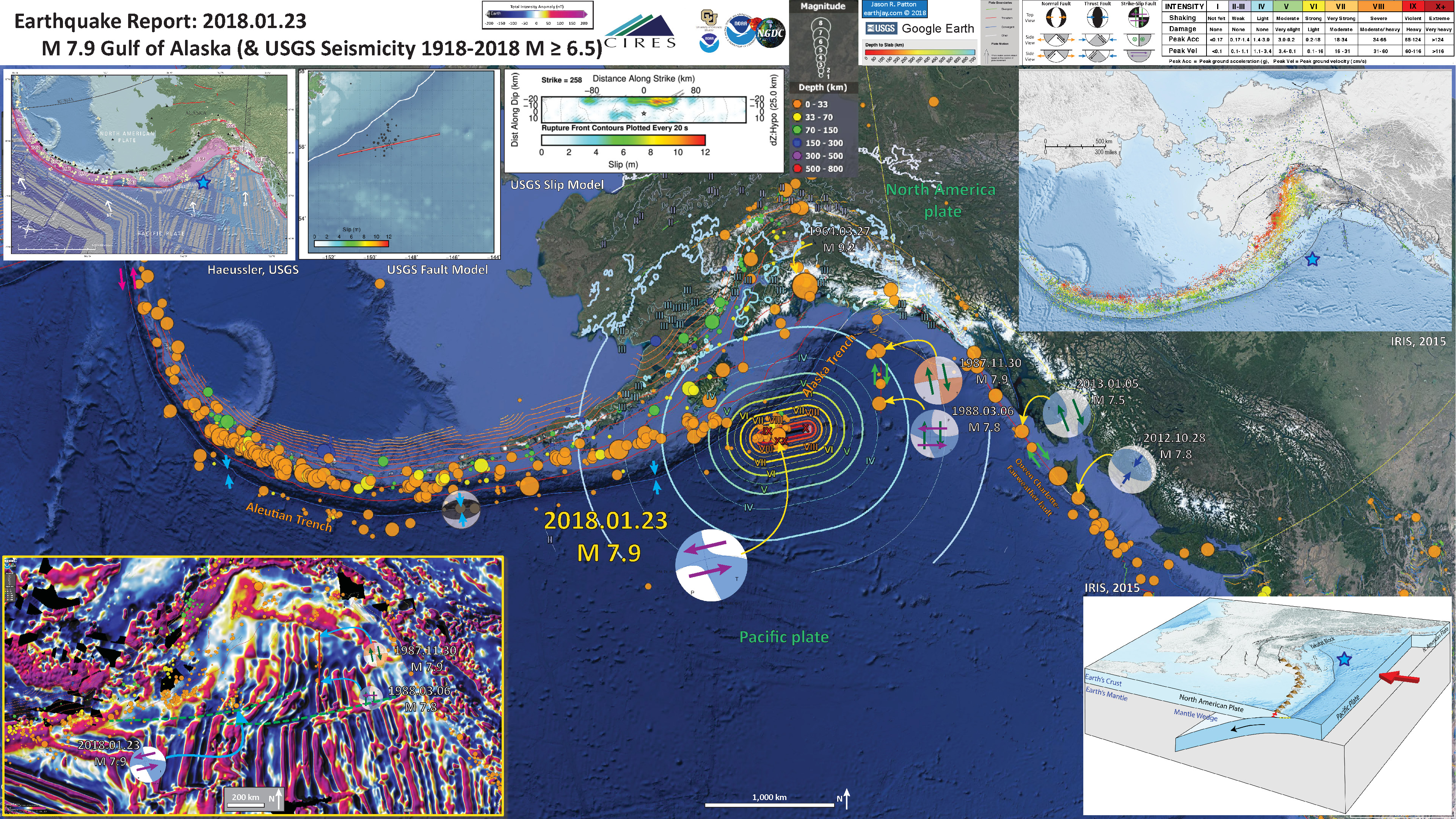
- Here is my original report. Below is the interpretive poster from that report.
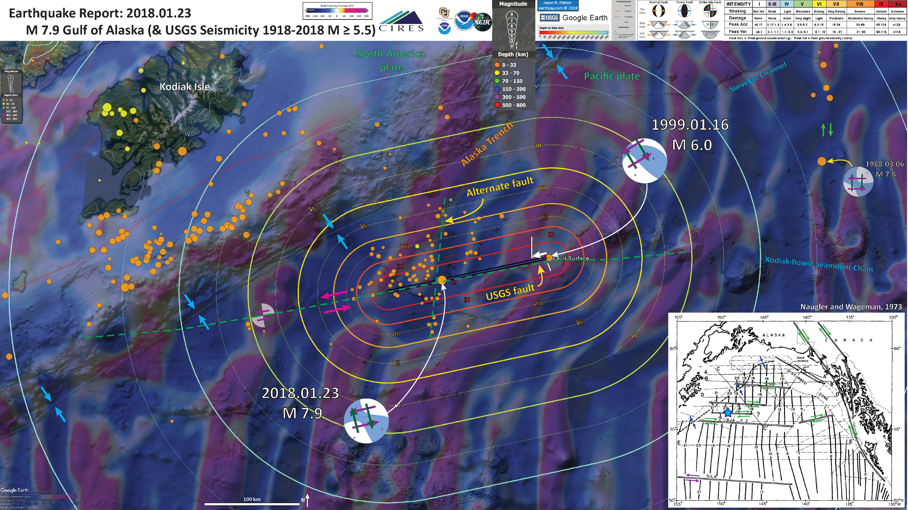
- Here is my UPDATE #1 report. Below is the interpretive poster from that report.
- Here is the seismograph at Humboldt State University, Dept. of Geology. The seismometer is located in the basement of Founders Hall, across from the Geology Dept. office.
Social Media
Magnitude 7.9 earthquake: Midnight shaking and confusion in an Alaskan Cabin | https://t.co/1twVj9WIVY https://t.co/6EwODnWQ0y via @temblor
— temblor (@temblor) January 24, 2018
the Alaska earthquake generated a small tsunami detected by @Ocean_Networks sensors off Canada's westcoast #tsunami pic.twitter.com/MK0K0SLOi8
— Kate Moran (@katemoran) January 23, 2018
Here's a time-magnitude plot of the sequence so far. 17 aftershocks with magnitudes in the 4-5 range. Also a map, but most of these have not been reviewed yet, so locations may be off. Of course there are many smaller aftershocks that we're not getting automatic locations for. pic.twitter.com/jnA9aDSZiQ
— AK Earthquake Center (@AKearthquake) January 23, 2018
Why Did Alaska’s Big Quake Lead to a Tiny Tsunami? #AlaskaEarthquakehttps://t.co/wdA0YoWOhZ
— IRIS Earthquake Sci (@IRIS_EPO) January 25, 2018
Here's an article about the rogue buoy data point: https://t.co/0PZTSVJFoD
— Brian Brettschneider (@Climatologist49) January 25, 2018
Is this a foreshock to the Mw 7.9 Gulf of Alaska quake? 30 October 2017, ~5km south on the apparent (& hypothesized by me) N-S striking sinistral strike-slip fault on which the quake initiated: https://t.co/YdTO2zBaBL Compare seismograms of that quake (left) w/ 24 Jan M4.1 eq pic.twitter.com/gHdfE5NkSc
— J H Gurney (@UKEQ_Bulletin) January 25, 2018
Did Tuesday’s M=7.9 Kodiak #earthquake nudge the Alaskan Megathrust closer to failure? https://t.co/nQqBkjI1Hv | @temblor | #alaskaearthquake pic.twitter.com/CpVAu4RjRT
— IRIS Earthquake Sci (@IRIS_EPO) January 27, 2018
- Summary of the 1964 Earthquake
- 2018.01.23 M 7.9 Gulf of Alaska
- 2018.01.23 M 7.9 Gulf of Alaska UPDATE #1
- 2018.01.23 M 7.9 Gulf of Alaska UPDATE #2
- 2017.07.17 M 7.7 Aleutians
- 2017.07.17 M 7.7 Aleutians UPDATE #1
- 2017.06.02 M 6.8 Aleutians
- 2017.05.08 M 6.2 Aleutians
- 2017.05.01 M 6.3 British Columbia
- 2017.03.29 M 6.6 Kamchatka
- 2017.03.02 M 5.5 Alaska
- 2016.09.05 M 6.3 Bering Kresla (west of Aleutians)
- 2016.04.13 M 5.7 & 6.4 Kamchatka
- 2016.04.02 M 6.2 Alaska Peninsula
- 2016.03.27 M 5.7 Aleutians
- 2016.03.12 M 6.3 Aleutians
- 2016.01.29 M 7.2 Kamchatka
- 2016.01.24 M 7.1 Alaska
- 2015.11.09 M 6.2 Aleutians
- 2015.11.02 M 5.9 Aleutians
- 2015.11.02 M 5.9 Aleutians (update)
- 2015.07.27 M 6.9 Aleutians
- 2015.05.29 M 6.7 Alaska Peninsula
- 2015.05.29 M 6.7 Alaska Peninsula (animations)
- 1964.03.27 M 9.2 Good Friday
Alaska | Kamchatka | Kurile
General Overview
Earthquake Reports
- Atwater, B.F., Yamaguchi, D.K., Bondevik, S., Barnhardt, W.A., Amidon, L.J., Benson, B.E., Skjerdal, G., Shulene, J.A., and Nanalyama ,F., 2001. Rapid resetting of an estuarine recorder of the 1964 Alaska earthquake in Geology, v. 113, no. 9, p. 1193-1204.
- Benz, H.M., Tarr, A.C., Hayes, G.P., Villaseñor, Antonio, Hayes, G.P., Furlong, K.P., Dart, R.L., and Rhea, Susan, 2011. Seismicity of the Earth 1900–2010 Aleutian arc and vicinity: U.S. Geological Survey Open-File Report 2010–1083-B, scale 1:5,000,000.
- Frisch, W., Meschede, M., Blakey, R., 2011. Plate Tectonics, Springer-Verlag, London, 213 pp.
- Hayes, G.P., Wald, D.J., and Johnson, R.L., 2012. Slab1.0: A three-dimensional model of global subduction zone geometries in, J. Geophys. Res., 117, B01302, doi:10.1029/2011JB008524
- Haeussler, P., Leith, W., Wald, D., Filson, J., Wolfe, C., and Applegate, D., 2014. Geophysical Advances Triggered by the 1964 Great Alaska Earthquake in EOS, Transactions, American Geophysical Union, v. 95, no. 17, p. 141-142.
- Koehler, R.D., Farrell, Rebecca-Ellen, Burns, P.A.C., and Combellick, R.A., 2012. Quaternary faults and folds in Alaska: A digital database, in Koehler, R.D., Quaternary Faults and Folds (QFF): Alaska Division of Geological & Geophysical Surveys Miscellaneous Publication 141, 31 p., 1 sheet, scale 1:3,700,000. doi:10.14509/23944
- Meng, L., Ampuero, J.-P., Stock, J., Duputel, Z., Luo, Y., and Tsai, V.C., 2012. Earthquake in a Maze: Compressional Rupture Branching During the 2012 Mw 8.6 Sumatra Earthquake in Science, v. 337, p. 724-726.
- Plafker, G., 1969. Tectonics of the March 27, 1964 Alaska earthquake: U.S. Geological Survey Professional Paper 543–I, 74 p., 2 sheets, scales 1:2,000,000 and 1:500,000, http://pubs.usgs.gov/pp/0543i/.
- Plafker, G., 1972. Alaskan earthquake of 1964 and Chilean earthquake of 1960: Implications for arc tectonics in Journal of Geophysical Research, v. 77, p. 901-925.
- Saltus, R.W., and Barnett, A., 2000. Eastern Aleutian Volcanic Arc Digital Model – Version 1.0: U.S. Geological Survey Open-File Report 00


