
Today we had a good sized earthquake along the S. Solomon trench, however, it was not a subduction zone earthquake, but a strike-slip earthquake in the downgoing plate.
-
Here are the largest earthquakes plotted in the map below.
- 2015.10.20 M 7.1
-
Along the New Hebrides trench
In the map below I plot the epicenters of earthquakes from the past 30 days of magnitude greater than M = 2.5. The epicenters have colors representing depth in km. The USGS plate boundaries are plotted vs color. The USGS modeled estimate for ground shaking is plotted with contours of equal ground shaking using the Modified Mercalli Intensity scale. I show the moment tensor for the M 6.8 earthquake, as well as for the M 7.1 from about a month ago. Here is the kmz file that I use in the map.
I placed a moment tensor / focal mechanism legend in the lower left corner of the map. There is more material from the USGS web sites about moment tensors and focal mechanisms (the beach ball symbols). Both moment tensors and focal mechanisms are solutions to seismologic data that reveal two possible interpretations for fault orientation and sense of motion. One must use other information, like the regional tectonics, to interpret which of the two possibilities is more likely.
Based upon the orientation of the fracture zones (strike-slip fault systems) in the plate formed along the Woodlark Spreading center, I interpret this M 6.8 earthquake to be striking north-south. Based on this, along with the moment tensor, I interpret this to be a right lateral strike-slip earthquake.
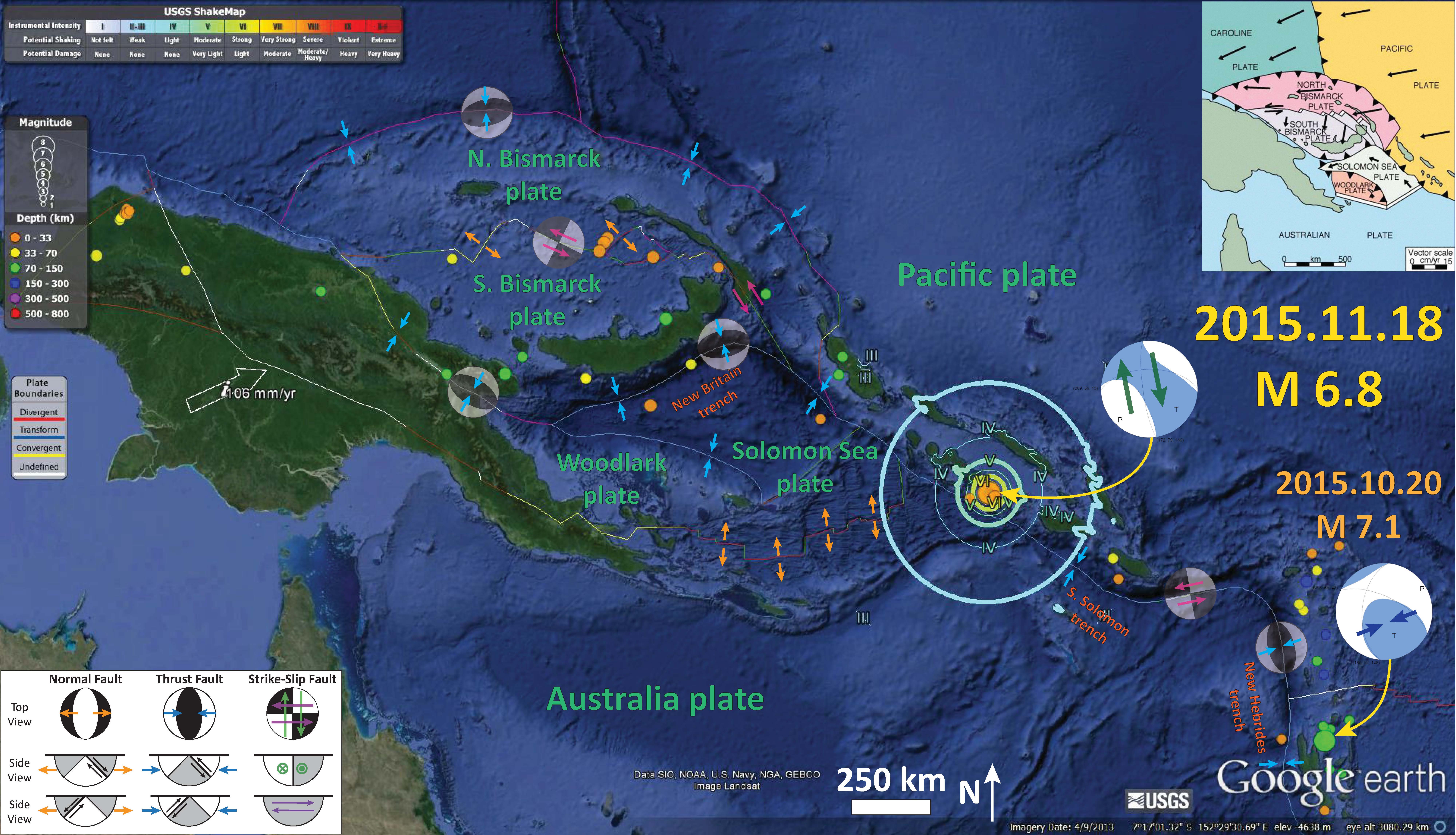
In the above map I also include a map that shows an interpretation of the regional tectonic setting (credit IRIS) modified from Hamilton (1979). The inset map shows plate velocity vectors.
Here is the same map as above, but with the slab contours plotted (Hayes et al., 2012), which are contours that represent the depth to the subduction zone fault. These are mostly based upon seismicity. The depths of the earthquakes have considerable error and do not all occur along the subduction zone faults, so these slab contours are simply the best estimate for the location of the fault. The hypocentral depth plots this close to the location of the fault as mapped by Hayes et al. (2012). So, the earthquake is either in the downgoing slab, or in the upper plate and a result of the seismogenic locked plate transferring the shear strain from a fracture zone in the downgoing plate to the upper plate.

This region has had several earthquakes with similar senses of motion in the last two years. In May of 2015, there was a thrust/reverse fault earthquake to the east of this M 6.6 earthquake. Here is a summary map that I put together with that, along with some other recent earthquakes plotted. This shows how these different plate boundaries have different types of earthquakes. The page for the May earthquake is here.
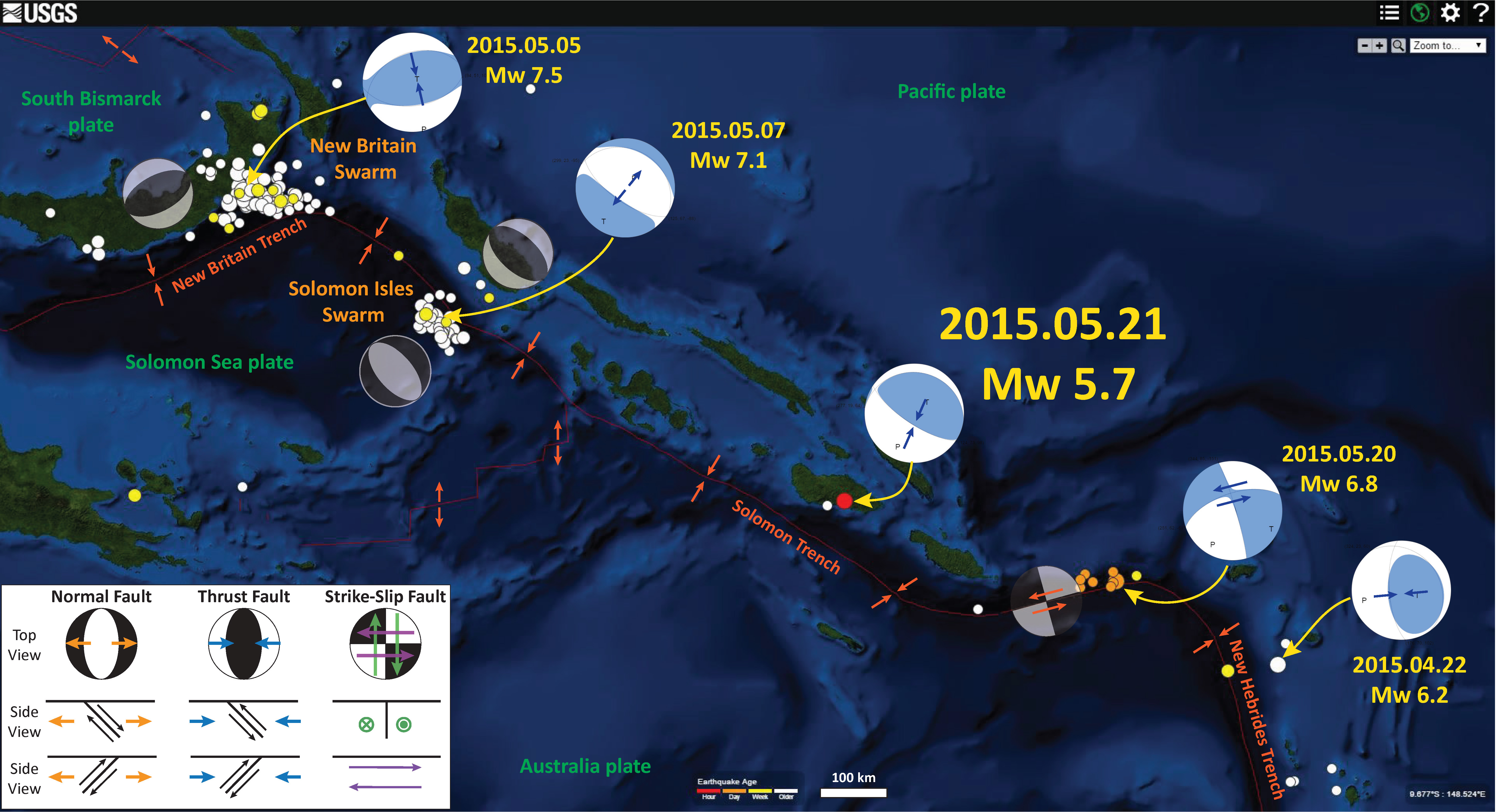
To the north and south of this epicentral region, the S. Solomon trench has had typical subduction zone compressional earthquakes. Also, further to the west, along the New Britain trench, there are also typical compressional earthquakes along the subduction zone there. I put together this map to show how the New Britain and Solomon trenches meet. Earthquakes along the New Britain trench have principal stress aligned perpendicular to the New Britain trench and earthquakes along the Solomon trench have principal stresses aligned perpendicular to the Solomon trench due to strain partitioning in the upper plate. I provide more links and explanations about these earthquakes on this page.

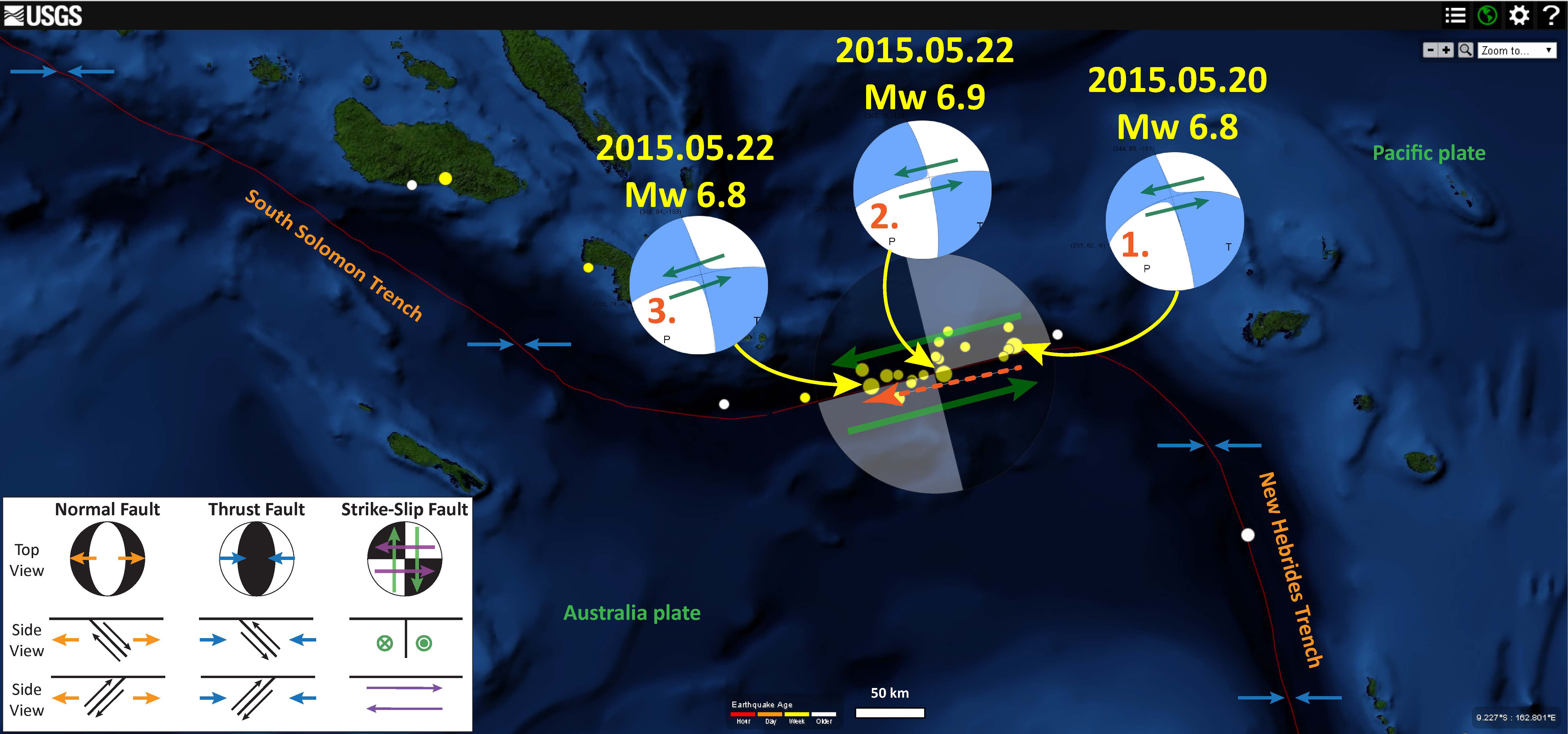
There were also three M = 6.8-6.9 earthquakes further to the south along a transform plate boundary (mapped as a subduction zone by the USGS). Here is a map that shows the location of this May earthquake swarm.
-
Here are my earthquake reports for a series of earthquakes in this region:
- 2014.04.11 M 7.1 subduction zone earthquake S. Solomon trench
- 2014.04.13 M 7.1 triggered earthquake at the southern S. Solomon trench
- 2014.12.06 M 6.8 subduction zone earthquake S. Solomon trench
- 2015.03.29 M 7.5 subduction zone earthquake New Britain trench
- 2015.05.21 M 5.7 subduction zone earthquake S. Solomon trench
- 2015.07.13 M 6.7 n-s strike-slip S. Solomon trench
- 2015.08.10 M 6.6 n-s strike-slip S. Solomon trench
- 2015.11.04 M 5.3 n-s strike-slip S. Bismarck plate
-
References:
- Hamilton, W., 1979, Tectonics of the Indonesian region: U.S. Geological Survey Prof. Paper 1078.
- Hayes, G. P., D. J. Wald, and R. L. Johnson (2012), Slab1.0: A three-dimensional model of global subduction zone geometries, J. Geophys. Res., 117, B01302, doi:10.1029/2011JB008524
1 thought on “Earthquake Report: Solomons!”