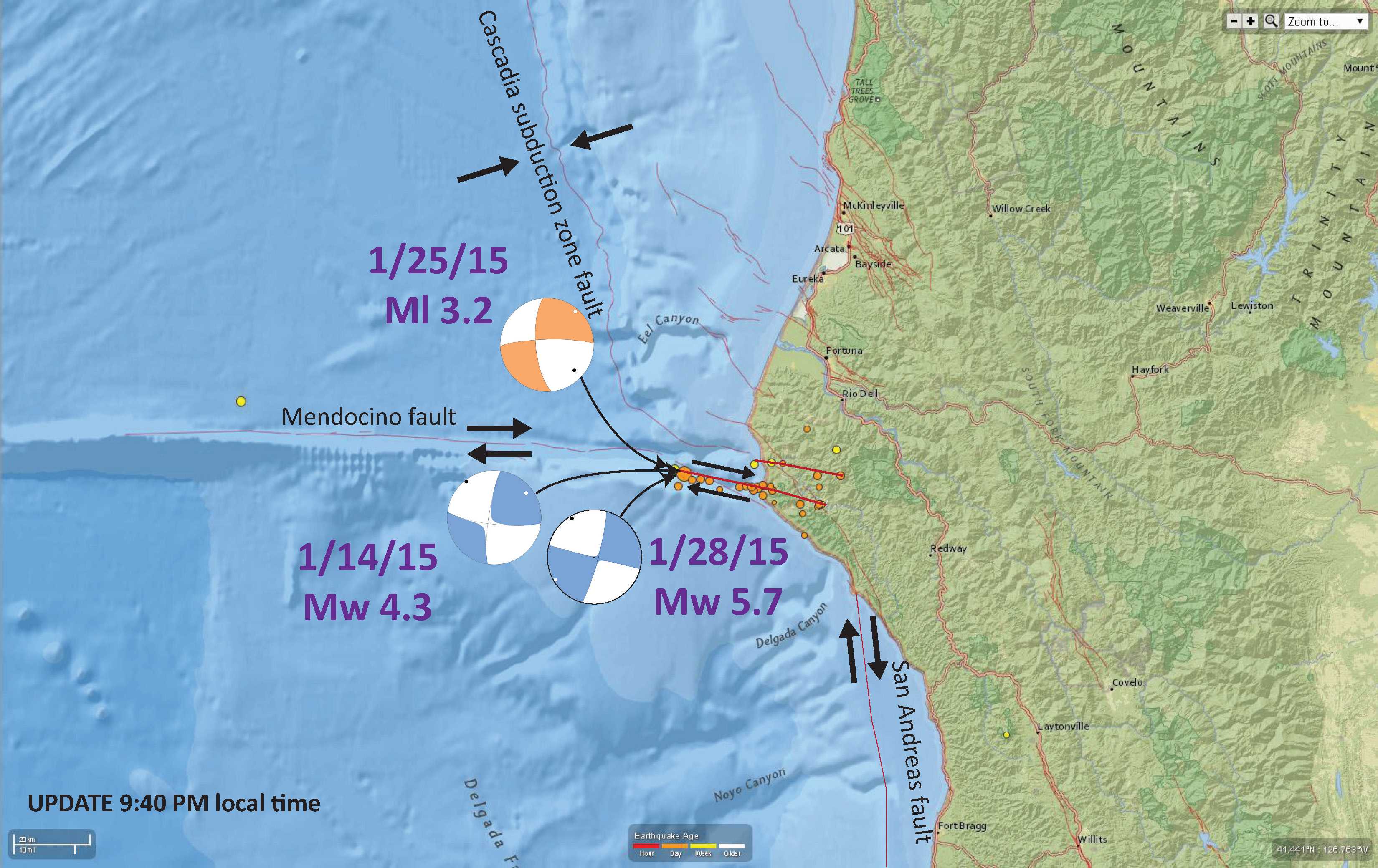
We just had a good sized shaker, probably on the Mendocino fault system. Today’s earthquake occurred on 1/28/2015 at 1:08 local time. The mainshock, an earthquake of magnitude Mw = 5.7, has an epicenter approximately 20 km due west of the mouth of the Mattole River. Please check back here soon as I am updating this page rapidly. I have now plotted one of the foreshocks in my interpretation figure below, a magnitude 3.2 earthquake that plots west of the Mw 5.7 mainshock. The M 3.2 happened on 1/25/15.
We do NOT expect a tsunami from this earthquake. The magnitude is small and the type of earthquake is strike slip.
According to the NCSS, there is a high likelihood of aftershocks. Read their statement here.
Here is a map showing the mainshock (the largest orange dot). The USGS active faults are also shown. There is also a big red dot, but that is plotted incorrectly.

Here is a more localized map, showing the shape of the seafloor as it relates to the deformation of the Mendocino Transform fault plate boundary. The Mendocino fault is a right-lateral strike-slip fault that separates the Gorda plate to the north from the Pacific plate to the south.

Here is a map with some interpretations plotted on it. I have labeled the three plate boundary faults along with their sense of motion. I have also placed the moment tensor of the Mw 5.7 main shock on this map. I have drawn two red lines of possible faults that may be responsible for for the earthquakes that ruptured today.
There are three types of earthquakes, strike-slip, compressional (reverse or thrust, depending upon the dip of the fault), and extensional (normal). Here is are some animations of these three types of earthquake faults. Many of the earthquakes people are familiar with in the Mendocino triple junction region are either compressional or strike slip. The following three animations are from IRIS.
Strike Slip:
Compressional:
Extensional:
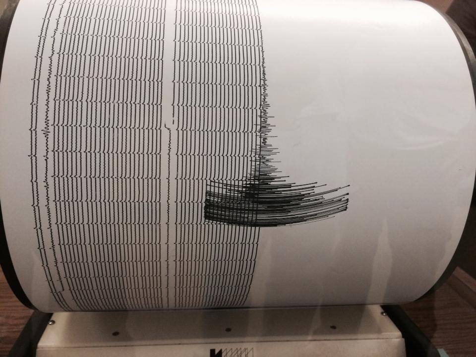
Here is a photo of the HSU Dept of Geology Seismograph.
Here is the regional map with the Did You Feel It shaking intensity data plotted. Please go to the USGS website to register your observations here. Your observations help us learn about the local geology.

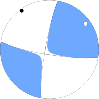
Here is the moment tensor for this earthquake. This is interpreted to be a strike slip earthquake based on this moment tensor.
This is the automated map showing expected Modified Mercalli Shaking Intensities for this earthquake. This is simply based on a model, while the DYFI map is actually based upon people’s observations (like yours!).

This DYFI map shows that people in Chico, California felt this earthquake! The earthquake was also felt in Oregon! Updated at 4:45 local time.

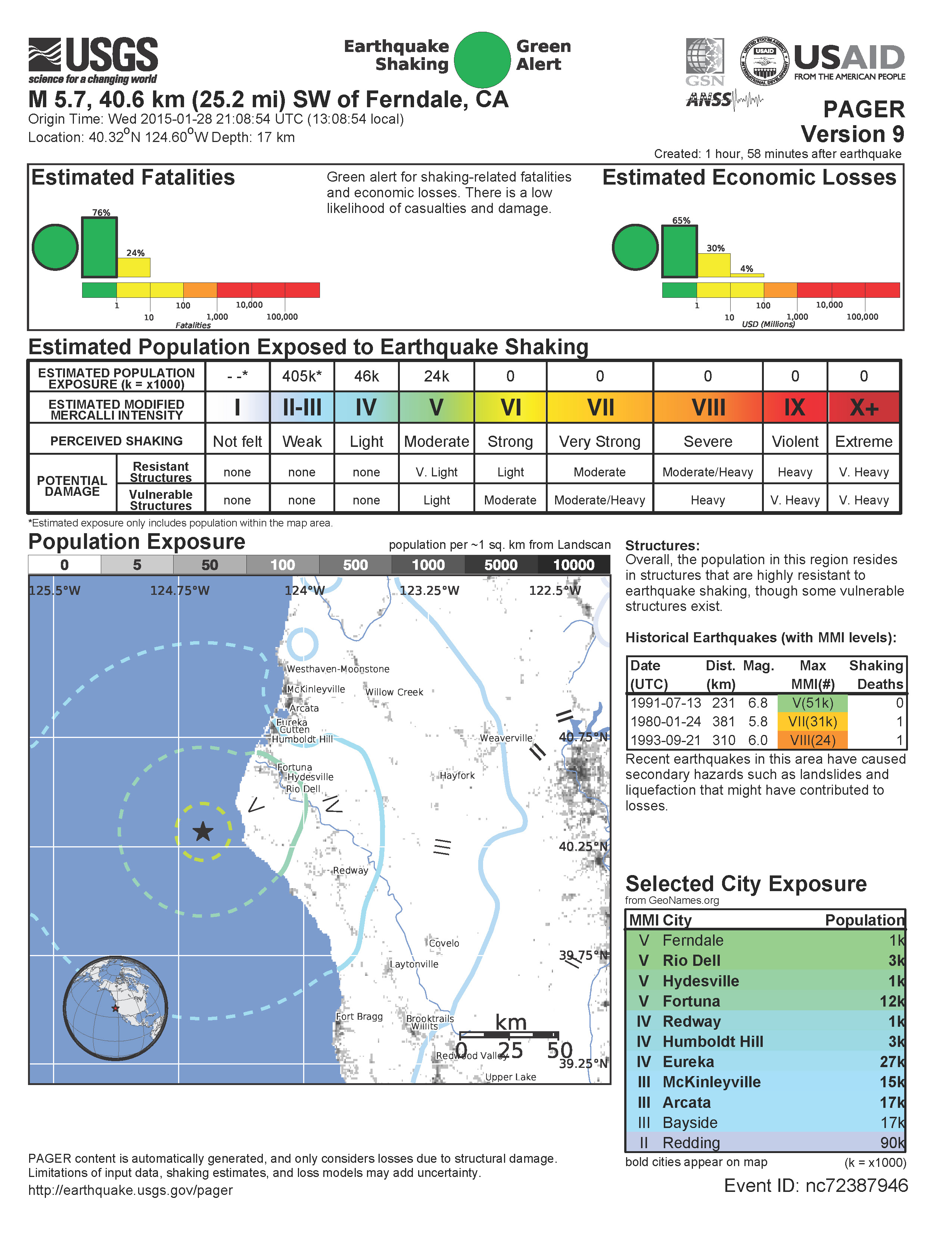
Here is the “PAGER” page that shows a modeled estimate of loss of human lives and their possessions (like buildings). There is actually a 24% likelihood that there may be between 1 and 10 fatalities!
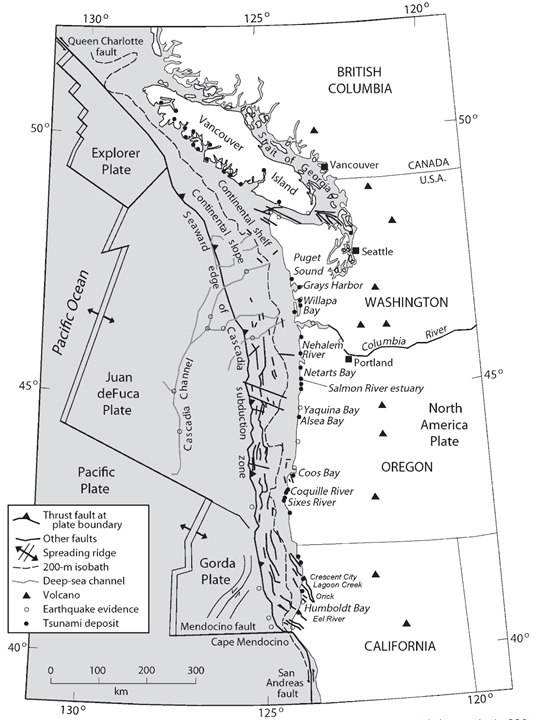
This is a map showing the plate configuration of our region. Today’s earthquake probably occurred along the Mendocino fault system. There is more information about the Cascadia subduction zone here. From Nelson et al., 2006.
Here is a primer that helps people learn how to interpret focal mechanisms and moment tensors. Moment tensors are calculated differently from focal mechanisms, but the interpretation of their graphical solution is similar. This is from the USGS.
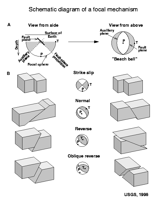
For more on the graphical representation of moment tensors and focal mechnisms, check this IRIS video out:
This figure shows what a transform plate boundary fault is. Looking down from outer space, the crust on either side of the fault moves side-by-side. When one is standing on the ground, on one side of the fault, looking across the fault as it moves… If the crust on the other side of the fault moves to the right, the fault is a “right lateral” strike slip fault. The Mendocino and San Andreas faults are right-lateral (dextral) strike-slip faults.
![]()
Here is an IRIS animation showing a transform plate boundary fault as it relates to spreading ridges.
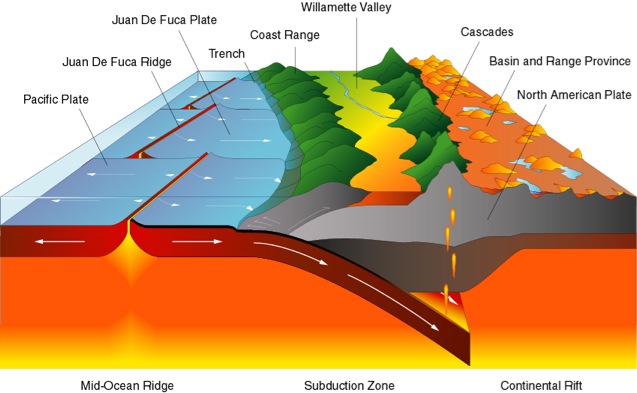
This shows a cross section and map view of the Cascadia subduction zone. There are other transform faults further north (e.g. the Blanco fracture zone), which are similar to the Mendocino fault. This cross section is at the latitude of the southern Willamette Valley.
Here is a map from Rollins and Stein (2010) that shows historic earthquakes in the Mendocino triple junction region. The earthquakes in 1994 and 1983 were also in the Mendocino fault. The 1983 swarm occurred in the same region as today’s Mw 5.7 swarm.

Here is a large scale map of the 1983 earthquake swarm. The mainshock epicenter is a black star and epicenters are denoted as white circles. Note how the aftershocks trend slightly southeast in this region. Today’s swarm does the same (and the moment tensor also shows a slightly southeast strike). Note how the interpreted fault dips slightly to the north, which is the result of north-south compression from the relative northward motion of the Pacific plate.

Here is a large scale map of the 1994 earthquake swarm. The mainshock epicenter is a black star and epicenters are denoted as white circles.

Here is a plot of focal mechanisms from the Dengler et al. (1995) paper in California Geology.

Here is a photo of the Rio Dell Bluffs taken by Mary Lou Willits today. According to her, the cliffs that are colored grey were newly exposed today (compared to the yellowish cliffs to the right).

References:
- Dengler, L.A., Moley, K.M., McPherson, R.C., Pasyanos, M., Dewey, J.W., and Murray, M., 1995. The September 1, 1994 Mendocino Fault Earthquake, California Geology, Marc/April 1995, p. 43-53.
- Rollins, J. C., and Stein, R. S., 2010, Coulomb Stress Interactions Among M ≥ 5.9 Earthquakes in the Gorda Deformation Zone and on the Mendocino Fault Zone, Cascadia Subduction Zone, and Northern San Andreas Fault: Journal of Geophysical Research, v. 115, no. B12306, p. 19 pp.
- Nelson, A.R., Kelsey, H.M., Witter, R.C., 2006. Great earthquakes of variable magnitude at the Cascadia subduction zone. Quaternary Research 65, 354-365.
we felt it off Broadway and Wabash in Eureka. Fun little roller.
I had major swaying and rattling here in Sunny Brae. One thing swayed for 10 minutes.
Thanks for the shoutouts man!
thanks chris, that paper is a gold mine for eye candy….
I had fun near Weott watching the electronic level tilt on a total station survey instrument, swinging for a nearly a minute!