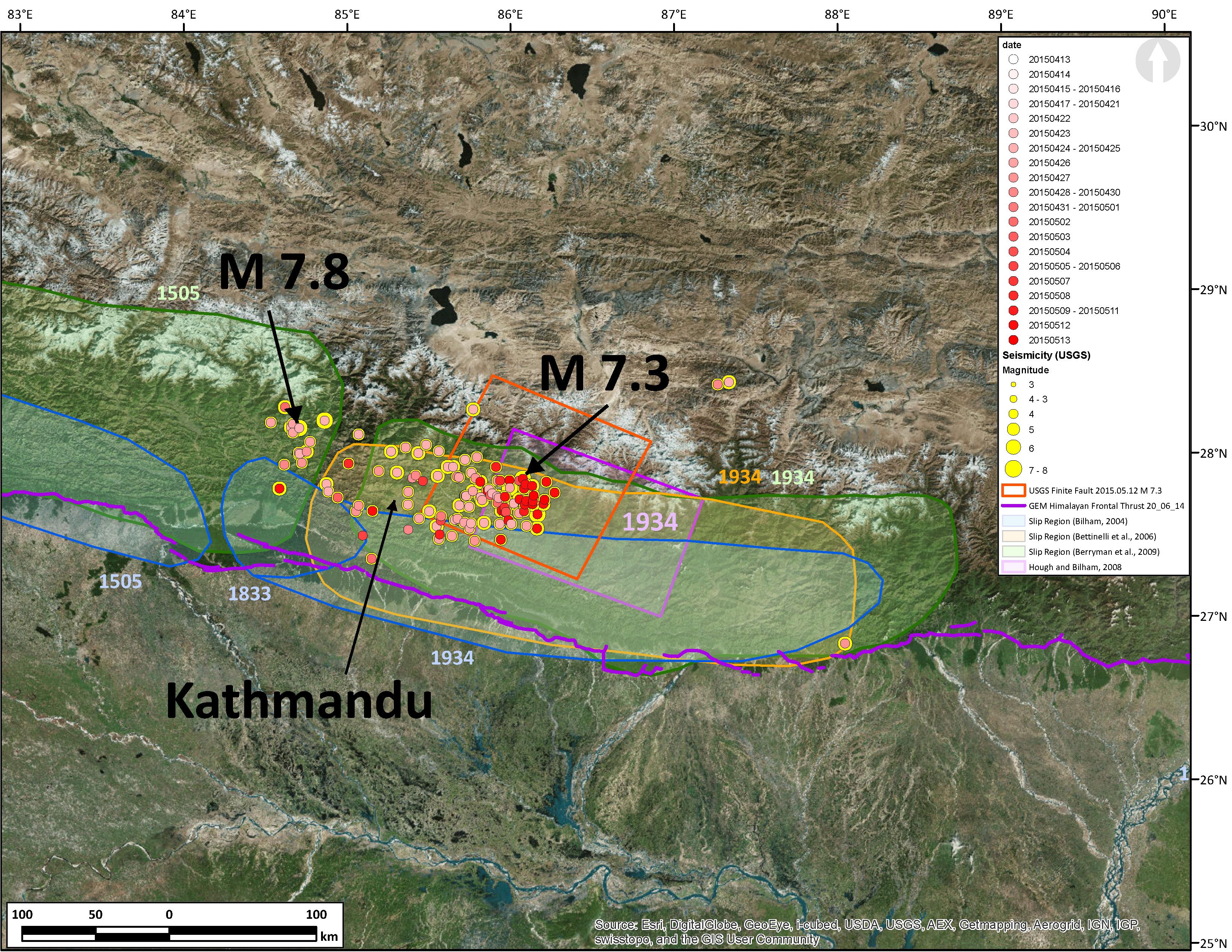
After some debate online, I decided to put this quick map together. Clicking on the epicenters in google earth or on the USGS earthquakes page, one can easily determine that there were aftershocks from the 2015.04.25 Mw 7.8 earthquake in the region of where the Mw 7.3 and associated May aftershocks were located. The May aftershocks extended the region of slip a little further to the east, though much of the fault had already slipped in this region in April.
Here is the map that I put together. I have placed the USGS epicenters with two color schemes. The size of the yellow dots represents earthquake magnitude. The degree of redness designates the time (earlier-April = pink & later-May = red). Note how there are some pink colored epicenters in the region of the M 7.3 earthquake. These pink colored earthquakes all occurred in April. The red ones are from May. These epicenters may not be plotted with the greatest certainty, though any uncertainty is possibly shared between them. So, there relative positions are possibly good.

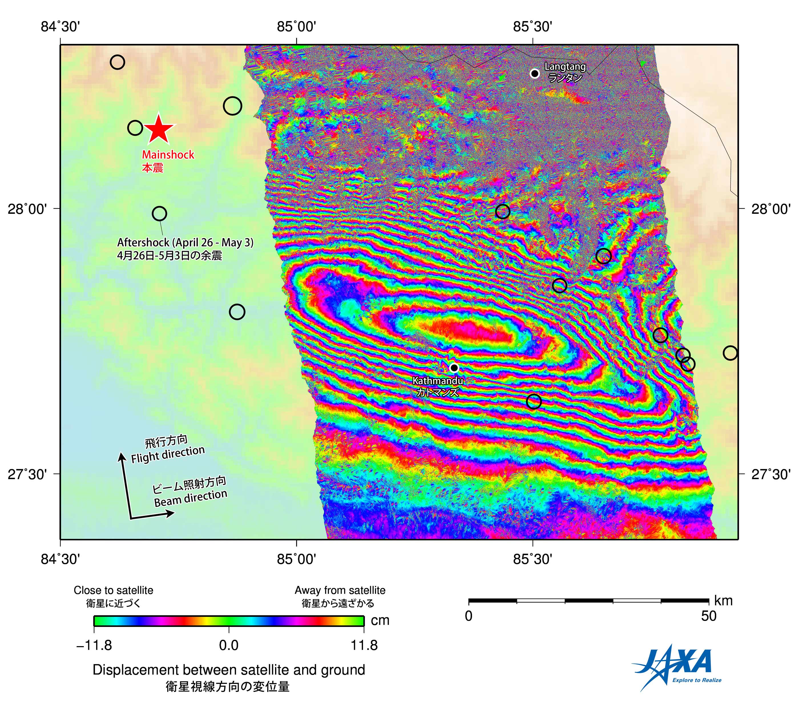
There is a team of Geophysicists at the Institute for Geophysics and Planetary Physics at University of California, San Diego (UCSD), the Earth Observation Research Center at the Japan Aerospace Exploration Agency (JAXA), and the Disaster Prevention Research Institute at Kyoto University who are analyzing the surface deformation from the Mw 7.8 mainshock (Lindsey et al., 2015). They think that the M 7.3 aftershock and associated aftershocks are occurring in a region of the fault that was stressed during the mainshock. This makes sense from a coulomb stress perspective. The small aftershocks that happened in this region east of Katmandu were small in magnitude and probably did not release much stress. See their post here.
Further work with the Advanced Land Observing Satellite (ALOS-2*ALOS), using satellite interferometry, have found that central Kathmandu has risen by about 1 meter. Here is a link to their page.

-
Here are some posts of mine related to this 2015 seismic swarm in Nepal.
- Mw 7.8 Mainshock Initial Post: original post and links to USGS
- Mw 7.8 Mainshock 1st Update: historic earthquakes
- Mw 7.8 Mainshock 2nd Update: ground motions
- Mw 7.8 Mainshock 3rd Update: surface displacement maps
- Mw 7.8 Mainshock 4th Update: updated historic seismicity maps
- Mw 7.8 Mainshock 5th Update: another surface deformation map
- M 7.3 Aftershock original post: epicenter map and PAGER estimate
- M 7.3 Aftershock 1st Update: updated maps with moment tensors
- M 7.3 Aftershock 2nd Update: updated maps with updated estimates of ground motion intensity, PAGER estimates, and USGS fault plane model
update 8:00 PM PST:
video from Ian Pierce from University of Nevada, Reno. They shot this video during the Mw 7.3 aftershock.
Interviews of Ian Pierce and Stephen Angster regarding their experience during the Mw 7.3 aftershock.
-
References:
- Bilham, R., Gaur, V.K., Molnar, P., 2001. Himalayan Seismic Hazard, Science, v. 293, p/ 1,442-1,444.
- Bilham, R., 2004. Earthquakes in India and the Himalaya: tectonics, geodesy and history, Annals of Geophysics, v. 42, no. 2/3, p. 839-858.
- Bettinelli, P., Avouac, J-P., Flouzat, M., Jouanne, F., Bollinger, L., Willis, P., and Chikitrar, G.R., 2006. Plate motion of India and interseismic strain in the Nepal Himalaya from GPS and DORIS measurements, Journal of Geodesy, v. 80, p. 567-589
- Berryman, K., Ries, W., Litchfield, N. (2009) The Himalayan Frontal Thrust: Attributes for seismic hazard Version 1.0, December 2014, GEM Faulted Earth Project, available from http://www.nexus.globalquakemodel.org/.
- Hough, S.E. and Bilham, R., 2008. Site response of the Ganges basin inferred from re-evaluated macroseismic observations from the 1897 Shillong, 1905 Kangra, and 1934 Nepal earthquakes, Journal of Earth System Sciences, v. 117, S2, November 2008, p. 773-782.
- Lindsey, E., R. Natsuaki, X. Xu, M. Shimada, H. Hashimoto, and D. Sandwell, (2015), Gorkha Mw 7.8 Earthquake: Line of Sight Deformation from ALOS-2 Interferometry, Seismological Research Letters, in prep, http://topex.ucsd.edu/nepal
Thanks a bunch for doing these graphics, Jay. They are very helpful to the Nepali. The Nepali instructors that I work with at the Khumbu Climbing Center are leaders in their respective communities, so basic information about the earthquakes, if made accessible to them, gets passed along to other people. I have found that this information not only helps them to understand this whole mess, but it really helps to reduce their fears about what might come next. With no knowledge, they conjure up all types of apocalyptic scenarios that will not happen. That said, no amount of information can minimize the tragedy and disruptions this event has brought to their lives. Thanks again…Rob
wow rob, I am really glad to hear that I am helping people. thanks. it is comments like yours that inspire me to continue to work on this. i am duly humbled.
I am sharing ur post…