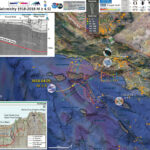
I awakened to be late to attending the GSA meeting today. I had not checked the time. 7am is too early, but i understand the time differences…
As i was logging into Zoom, my coworker emailed our Tsunami Unit group about a M7 in the eastern Mediterranean. So, I shifted gears a bit. But i had my poster to present, so i had to stay somewhat focused on that.
https://earthquake.usgs.gov/earthquakes/eventpage/us7000c7y0/executive
Today, in the wee hours (my time in California), there was a M 7.0 earthquake offshore of western Turkey in the Icarian Sea. The earthquake mechanism (i.e. focal mechanism or moment tensor) was for an extensional type of an earthquake, slip along a normal fault.
I immediately thought about some quakes/deprems that happened there several years ago. This area is an interesting and complicated part of the world, tectonically.
- 2017.07.20 M 6.7 Turkey
- 2017.06.12 M 6.3 Turkey/Greece
To the north is a strike-slip plate boundary localized along the North Anatolia fault system. This is a right lateral fault system, where the plates move side by side, relative to each other. See the introductory information links below to learn more about different types of faults.
To the south is a convergent plate boundary (plates are moving towards each other) related to (1) the Alpide Belt, a convergent plate boundary formed in the Cenozoic that extends from Australia to Morocco. On the southern side of Greece and western Turkey, there are subduction zones where the Africa plate dives northward beneath the Eurasia and Anatolia plates.
The region of today’s earthquake is in a zone of north-south oriented extension. This extension appears to be in part due to gravitational collapse of uplifted metamorphic core complexes.
There are several “massifs” that were emplaced in the past, lifted up, creating gravitational potential. The normal faults may have formed as the upper crust extended. It is complicated here, so i am probably missing some details. But, with the references i provide below, y’all can read more on your own. Feel free to contact me if i wrote something incorrect. I love my peer reviewers (you).
So, this N-S extension creates east-west oriented valleys/basins with E-W striking (trending) faults. There are south dipping faults on the north sides and north dipping faults on the south side of these valleys.
These structures are called rifts. A famous rift is the East Africa Rift.
There are two main rifts in western Turkey, the Büyük Menderes Graben and the Küçük Menderes Graben Systems. If we project these rifts westward, we can see another rift, the rift that forms the Gulf of Corinth in Greece, the Gulf of Corinth Rift. This is one of the most actively spreading rifts in the world.
In addition to the large earthquake, which caused lots of building damage and also caused over a dozen deaths so far (sadly), there was recorded a tsunami on the tide gages in the region. I use the IOC website to obtain tide gage data. This is an excellent service. There are only a few national tide gage online websites that rival this one.
It is also highly likely that there were landslides or that there was liquefaction somewhere in the region. The USGS models i present below show a high likelihood for these earthquake triggered processes.
Below is my interpretive poster for this earthquake
- I plot the seismicity from the past month, with diameter representing magnitude (see legend). I include earthquake epicenters from 1920-2020 with magnitudes M ≥ 7.0 in one version.
- I plot the USGS fault plane solutions (moment tensors in blue and focal mechanisms in orange), possibly in addition to some relevant historic earthquakes.
- A review of the basic base map variations and data that I use for the interpretive posters can be found on the Earthquake Reports page. I have improved these posters over time and some of this background information applies to the older posters.
- Some basic fundamentals of earthquake geology and plate tectonics can be found on the Earthquake Plate Tectonic Fundamentals page.
- On the left is a map from Armijo et al. (1999) that shows the plate boundary faults and tectonic plates in the region. This M 7.0 earthquake, denoted by the blue circle.
- In the upper left corner is a map that shows the tectonic strain in the region. Areas of red are deforming more from tectonic motion than are areas that are blue. Learn more about the Global Strain Rate Map project here.
- To the right of the strain map is a comparison of the shaking intensity modeled by the USGS and the shaking intensity based on peoples’ “boots on the ground” observations. A modeled estimate of intensity is shown by the color overlay and labels MMI 4, 5, 6, 7. The USGS Did You Feel It observations are the colored circles (color = intensity) and labeled dyfi 6.2 for example.
- On the upper right and right center are two maps that show (bottom) liquefaction susceptibility and (top) landslide probability. These are based on empirical models from the USGS that show the chance an area may have experienced these processes that may have happened as a result of the ground shaking from the earthquake. I spend more time explaining these types of models and what they represent in this Earthquake Report for the recent event in Albania.
- Faults shown on these maps come from the DISS fault database from INGV and their collaborators. These data have been incorporated into the Global Earthquake Model. The red lines represent the top of the fault plane and the green shapes represent the fault planes as they dip into the Earth. Note how the North Anatolia fault, which is a vertically dipping strike-slip fault, appears to not have fault planes. Why do you think that is?
- In the lower right corner is a map showing epicenters for earthquakes since 30 July 2020 (from EMSC).
- Along the bottom of the poster are several tsunami plots from the region. The Bodrum tide gage is on a south facing shoreline, so the waves are not directed directly at this gage. The Kos Marina and Hrakleio gages are more directly facing the earthquake. Note which gages have larger waves. Why do you think this is so?
I include some inset figures. Some of the same figures are located in different places on the larger scale map below.
- Here is the map with a month’s seismicity plotted.
- For the century record of M>7 earthquakes I use the USGS National Earthquake Information Center as a source of data.
- However, there is a local network of earthquake records from CSEM EMSC here.
- Here are the main tide gages that have decent tsunami records in the Aegean region. I offset these records vertically a modest amount for the plot, so disregard the absolute elevation values.
- I made a crude measurements for the wave height of these tsunami records (neglecting to take into account changes in tide). The locations are shown in the map.
Other Report Pages
Some Relevant Discussion and Figures
- Here is a lovely plate tectonic overview map, highlighting the plate boundary faults, as well as the crustal faults (Taymaz et a., 2007).
Seismicity of the Eastern Mediterranean region and surroundings reported by USGS–NEIC during 1973–2007 with magnitudes for M . 3 superimposed on a shaded relief map derived from the GTOPO-30 Global Topography Data taken after USGS. Bathymetry data are derived from GEBCO/97–BODC, provided by GEBCO (1997) and Smith & Sandwell (1997a, b).
- Here is the tectonic map from Dilek and Sandvol (2009).
Tectonic map of the Aegean and eastern Mediterranean region showing the main plate boundaries, major suture zones, fault systems and tectonic units. Thick, white arrows depict the direction and magnitude (mm a21) of plate convergence; grey arrows mark the direction of extension (Miocene–Recent). Orange and purple delineate Eurasian and African plate affinities, respectively. Key to lettering: BF, Burdur fault; CACC, Central Anatolian Crystalline Complex; DKF, Datc¸a–Kale fault (part of the SW Anatolian Shear Zone); EAFZ, East Anatolian fault zone; EF, Ecemis fault; EKP, Erzurum–Kars Plateau; IASZ, Izmir–Ankara suture zone; IPS, Intra–Pontide suture zone; ITS, Inner–Tauride suture; KF, Kefalonia fault; KOTJ, Karliova triple junction; MM, Menderes massif; MS, Marmara Sea; MTR, Maras triple junction; NAFZ, North Anatolian fault zone; OF, Ovacik fault; PSF, Pampak–Sevan fault; TF, Tutak fault; TGF, Tuzgo¨lu¨ fault; TIP, Turkish–Iranian plateau (modified from Dilek 2006).
- This is the Wouldloper (2009) tectonic map of the Mediterranean Sea.
- This is a fantastic figure, yet quite complicated. This map shows teh plate boundaries, the GPS motions, and the tectonic strain for the region (Perouse et al., 2012).
- We use GPS sites at specific locations to measure how fast the Earth’s crust moves due to plate tectonics and other reasons. These GPS sites are almost constantly recording their geographic position. If a GPS site is moving, we can take two observations (lets say a year apart), measure their relative distance, and divide the time between the measurements to get the velocity (the speed) that this GPS site is moving. The white vectors (the arrows) show the direction those GPS sites are moving and the length of the vector represents its velocity. The black arrows show what the plate motion rates are at the plate boundaries and these are modeled using lots of different data sources (not just GPS).
- Tectonic strain is a measure of how much the Earth’s crust is deforming over time. The higher the tectonic strain rate (i.e. red), the more tectonic stress is being accumulated in the crust and along faults. Areas of higher strain are places where there are more likely to be larger or more (or both) earthquakes.
Present-day kinematic and tectonic map encompassing the Central and Eastern Mediterranean, summarizing our main results and interpretations. Our kinematic model includes rigid-block motions as well as localized and distributed strain. Central-SW Aegean block (CSW AEG block) and East Anatolian block (East Anat. block) are purely kinematic and directly results from strain modeling (Figure 5). AP-IO Block is our Apulian-Ionian block with tentative tectonic boundaries. Rotation pole of this Apulian-Ionian block relative to Nubia (Nu WAp-Io) and to Eurasia (Eu WAp-Io) are shown with their 95% confidence ellipse.
- This is the Ersoy et al. (2014) map showing their interpretation of the modern deformation in the northern Aegean Sea and western Turkey.
Geological map showing the distribution of the Menderes Extensional Metamorphic Complex (MEMC), Oligocene–Miocene volcanic and sedimentary units and volcanic centers in the Aegean Extensional Province (compiled from geological maps of Greece (IGME) and Turkey (MTA), and adapted from Ersoy and Palmer, 2013). Extensional deformation field with rotation (rotational extension) is shown with gray field, and simplified from Brun and Sokoutis (2012), Kissel et al. (2003) and van Hinsbergen and Schmid (2012). İzmir–Balıkesir Transfer zone (İBTZ) give the outer limit for the rotational extension, and also limit of ellipsoidal structure of the MEMC. MEMC developed in two stages: the first one was accommodated during early Miocene by the Simav Detachment Fault (SDF) in the north; and the second one developed during Middle Miocene along the Gediz (Alaşehir) Detachment Fault (GDF) and Küçük Menderes Detachment Fault (KMDF). Extensional detachments were also accommodated by strike-slip movement along the İBTZ (Ersoy et al., 2011) and Uşak–Muğla Transfer Zone (Çemen et al., 2006; Karaoğlu and Helvacı, 2012). Other main core complexes in the Aegean, the Central Rhodope (CRCC), Southern Rhodope (SRCC), Kesebir–Kardamos Dome (KKD) and Cycladic (CCC) Core Complexes are also shown. The area bordered with dashed green line represents the surface trace of the asthenospheric window between the Aegean and Cyprean subducted slabs (Biryol et al., 2011; de Boorder et al., 1998). See text for detail.
- This is a great figure showing another interpretation to explain the extension in this region (slab rollback and mantle flow) from Brun and Sokoutis (2012).
Mantle flow pattern at Aegean scale powered by slab rollback in rotation around vertical axis located at Scutary-Pec (Albania). A: Map view of fl ow lines above (red) and below (blue) slab. B: Three-dimensional sketch showing how slab tear may accommodate slab rotation. Mantle fl ow above and below slab in red and blue, respectively. Yellow arrows show crustal stretching.
A: Tectonic map of the Aegean and Anatolian region showing the main active structures
(black lines), the main sutures zones (thick violet or blue lines), the main thrusts in the Hellenides where they have not been reworked by later extension (thin blue lines), the North Cycladic Detachment (NCDS, in red) and its extension in the Simav Detachment (SD), the main metamorphic units and their contacts; AlW: Almyropotamos window; BD: Bey Daglari; CB: Cycladic Basement; CBBT: Cycladic Basement basal thrust; CBS: Cycladic Blueschists; CHSZ: Central Hellenic Shear Zone; CR: Corinth Rift; CRMC: Central Rhodope Metamorphic Complex; GT: Gavrovo–Tripolitza Nappe; KD: Kazdag dome; KeD: Kerdylion Detachment; KKD: Kesebir–Kardamos dome; KT: Kephalonia Transform Fault; LN: Lycian Nappes; LNBT: Lycian Nappes Basal Thrust; MCC: Metamorphic Core Complex; MG: Menderes Grabens; NAT: North Aegean Trough; NCDS: North Cycladic Detachment System; NSZ: Nestos Shear Zone; OlW: Olympos Window; OsW: Ossa Window; OSZ: Ören Shear Zone; Pel.: Peloponnese; ÖU: Ören Unit; PQN: Phyllite–Quartzite Nappe; SiD: Simav Detachment; SRCC: South Rhodope Core Complex; StD: Strymon Detachment; WCDS: West Cycladic Detachment System; ZD: Zaroukla Detachment. B: Seismicity. Earthquakes are taken from the USGS-NEIC database. Colour of symbols gives the depth (blue for shallow depths) and size gives the magnitude (from 4.5 to 7.6).
C: GPS velocity field with a fixed Eurasia after Reilinger et al. (2010) D: the domain affected by distributed post-orogenic extension in the Oligocene and the Miocene and the stretching lineations in the exhumed metamorphic complexes.
E: The thick blue lines illustrate the schematized position of the slab at ~150 km according to the tomographic model of Piromallo and Morelli (2003), and show the disruption of the slab at three positions and possible ages of these tears discussed in the text. Velocity anomalies are displayed in percentages with respect to the reference model sp6 (Morelli and Dziewonski, 1993). Coloured symbols represent the volcanic centres between 0 and 3 Ma after Pe-Piper and Piper (2006). F: Seismic anisotropy obtained from SKS waves (blue bars, Paul et al., 2010) and Rayleigh waves (green and orange bars, Endrun et al., 2011). See also Sandvol et al. (2003). Blue lines show the direction of stretching in the asthenosphere, green bars represent the stretching in the lithospheric mantle and orange bars in the lower crust.
G: Focal mechanisms of earthquakes over the Aegean Anatolian region.
- Here is another map showing the GPS plate motion rates from Perouse et al. (2012). Note the scale on the two map panels are different. The rates on the map on the right are much faster than the rates in Africa.
Input GPS velocities of the model. Velocities are in Eurasia fixed reference frame with their respective 95% confidence ellipse. Velocity vectors are color coded relative to the study they have been taken from (see paper for more details). (a) GPS velocities of the entire Nubian plate used to constrain the Nubia–Eurasia relative motion. Nubia–Eurasia rotation pole defined in this and previous studies are shown with their 1s confidence ellipse: circle, Calais et al. [2003]; diamond, Le Pichon and Kreemer [2010]; open square, D’Agostino et al. [2008]; triangle, Argus et al. [2010]; filled square, Reilinger et al. [2006]; red star, present study. Parameters of these rotation poles are summarized in Table 2. (b) Focus on the GPS velocities in the Central and Eastern Mediterranean region.
- Here is a map that shows historic earthquake mechanisms (Perouse et al., 2012).
Input seismic moment tensors of the model. Fault plane solutions are from the Harvard CMT catalog (from 1976 to 2007) and the Regional Centroid Moment Tensor (RCMT) catalog (from 1995 to 2007). Location and hypocenter depth of the events are relocalized according to the Engdahl et al. [1998] catalog.
Those Rifts
- First we can see this map that highlights all the grabens mapped in the region. A graben is basically a block of Earth that has moved relatively down, forming a valley.
- These grabens are bound on at least one side by a normal fault (shown here with stippled lines pointing in the direction that the faults dip into the Earth.
Outline geological map of western Anatolia showing Neogene and Quaternary basins [simplified from Bingo1 (1989).
- Here is a map of the western part of the Buyuk Menderes Graben valley (Bozcurt 2000). The main reason to show this is because it shows the location of the cross-section shown next (in the box labeled “Figure 6b”).
- The island labeled Chios here is also called Samos on other maps.
- Here is the cross section that shows their interpretation of the tectonic faults in the subsurface.
Simplified geological map of the northern margin of the Btiytik Menderes Graben in the area between Germencik and Umurlu.
Geological cross-section of the northern margin of the Bt~yt~k Menderes Graben (see Fig. 6b for location) based on fig. llb of Cohen et al. (1995). This cross-section indicates a total of c. 5 km of extension. Assuming a uniform extension rate, the age of the fault zone is (c. 5 km/1 mm a -1) 5 Ma. More details in the paper.
- Here is a low-angle oblique illustrative view of the Graben forming basin common in the region (Emre and Sozbilir, 2007..
- Let’s now venture offshore into the ocean. This map shows some geologic units, some mapped crustal faults, and some seismic lines (Ocakoglu et al., 2005). These seismic lines are shown as rows of dots.
- Each straight dotted line represents a path that a research vessel took to make observations about the subsurface using seismic waves. The 30 Oct 2020 M 7.0 earthquake was to the north of Samos.
- None of the seismic lines are optimally located to look for the fault that ruptured earlier today, but they may help us learn about what might be possible here.
- Here are some seismic lines (seismic reflection profiles), whose locations are shown on the above map. The upper two panels are relevant (see line 10 on the map). These are consistent with normal faults on the north side of the basin.
- I include this map to show that there are lots of faults in this area. This is their final fault map based on the interpretations of many seismic lines.
Geology map of the study area (simplified from MTA 1: 500,000 scale geology map) and location of the seismic lines. Active faults are marked onland with bold lines.
Time migrated seismic sections, offshore Teke and Karaburun, showing active normal faults marked with white lines and strike-slip faults with black lines (see Fig. 3A for locations). Vertical exaggeration is ~2. Observed vertical displacement on the seafloor and basement surface by normal fault (marked with bold circle on Line-10) looks the same, thus this normal fault is Quaternary age. On line-18, vertical displacement seen on basement units are greater than displacement on Pliocene–Quaternary deposits due to fault marked with a bold circle thus this normal fault can be interpreted as Later Miocene–Pliocene age.
(A) The correlations between offshore and onshore active fault systems in the study region. N–S, NE–SW and NW–SE oriented lines and dashed-lines show interpreted active strike-slip faults and their possible extensions. These faults are annotated with dNT for those at north and dST for those at south. E–W oriented lines and dashed lines show interpreted active normal faults and their possible continuations, with footwalls indicated by the plus symbol. (B) Simplified active fault map of the study area. The bold lines show the master active faults. (C) Pureshear model can explain the development of active structures in the study area.
- Below are a map and a cross section further to the east, in the eastern part of the Büyük Menderes Graben (Kaya, 2015). They were studying geotherm water in the region as it relates to the fault geometry and other factors. and, well, who doesn’t like a little pre-planning at a hot spring?
- Here is the cross-section, showing normal faults bounding the graben.
Geological map of western Turkey showing the Menderes massif and its subdivision into the AG Alasehir graben, the BMG Büyük Menderes graben, the CMM Central Menderes massif, the KMG Küçük Menderes graben, the NMM Northern Menderes massif and the SMM Southern Menderes massif, modified from Sengör and Bozkurt (2013).
(a) A conceptual model of geothermal circulation in the study area, (b) a deep seismic profile with the N–S direction taken from a 30 km west of study area (Nazilli region) (Çifçi et al., 2011). Roman numerals indicate the different sedimentary sequences.
- Let’s look at this yet another way. Below is a map and series of cross sections along the Küçük Menderes Graben (KMG). Rojay et al. (2005) take a look at the Plio-Quaternary history of the KMG. The KMG is the rift to the north of the Buyuk Menderes Graben.
- Here is a series of cross sections along this basin, locaions are shown on the previous map.
- Here is their model of how the regional deformation is driven by the metamorphic core complex process.
Simplified geological map of the KMG showing the positions of geological cross-sections.
Series of geological cross-sections showing various sectors of the KMG depicting horst and graben structures overprinted onto the huge synclinal structure (see Fig. 3 for positions of geological cross-sections).
Schematic tentative cross-sections showing the Miocene to Quaternary evolution of the KMG (modified from Erinç [66]). Note the continuing extension since Miocene.
Regional Cross Sections
- The following three figures are from Dilek and Sandvol, 2006. The locations of the cross sections are shown on the map as orange lines. Cross section G-G’ is located in the region of today’s earthquake.
- Here is the map (Dilek and Sandvol, 2006). I include the figure caption below in blockquote.
- Here are cross sections A-D (Dilek and Sandvol, 2006). I include the figure caption below in blockquote.
- (A) Eastern Alps. The collision of Adria with Europe produced a bidivergent crustal architecture with both NNW- and SSE-directed nappe structures that involved Tertiary molasse deposits, with deep-seated thrust faults that exhumed lower crustal rocks. The Austro-Alpine units north of the Peri-Adriatic lineament represent the allochthonous outliers of the Adriatic upper crust tectonically resting on the underplating European crust. The Penninic ophiolites mark the remnants of the Mesozoic ocean basin (Meliata). The Oligocene granitoids between the Tauern window and the Peri-Adriatic lineament represent the postcollisional intrusions in the eastern Alps. Modified from Castellarin et al. (2006), with additional data from Coward and Dietrich (1989); Lüschen et al. (2006); Ortner et al. (2006).
- (B) Northern Apennines. Following the collision of Adria with the Apenninic platform and Europe in the late Miocene, the westward subduction of the Adriatic lithosphere and the slab roll-back (eastward) produced a broad extensional regime in the west (Apenninic back-arc extension) affecting the Alpine orogenic crust, and also a frontal thrust belt to the east. Lithospheric-scale extension in this broad back-arc environment above the west-dipping Adria lithosphere resulted in the development of a large boudinage structure in the European (Alpine) lithosphere. Modified from Doglioni et al. (1999), with data from Spakman and Wortel (2004); Zeck (1999).
- (C) Western Mediterranean–Southern Apennines–Calabria. The westward subduction of the Ionian seafloor as part of Adria since ca. 23 Ma and the associated slab roll-back have induced eastward-progressing extension and lithospheric necking through time, producing a series of basins. Rifting of Sardinia from continental Europe developed the Gulf of Lion passive margin and the Algero-Provencal basin (ca. 15–10 Ma), then the Vavilov and Marsili sub-basins in the broader Tyrrhenian basin to the east (ca. 5 Ma to present). Eastward-migrating lithospheric-scale extension and
necking and asthenospheric upwelling have produced locally well-developed alkaline volcanism (e.g., Sardinia). Slab tear or detachment in the Calabria segment of Adria, as imaged through seismic tomography (Spakman and Wortel, 2004), is probably responsible for asthenospheric upwelling and alkaline volcanism in southern Calabria and eastern Sicily (e.g., Mount Etna). Modified from Séranne (1999), with additional data from Spakman et al. (1993); Doglioni et al. (1999); Spakman and Wortel (2004); Lentini et al. (this volume). - (D) Southern Apennines–Albanides–Hellenides. Note the break where the Adriatic Sea is located between the western and eastern sections along this traverse. The Adria plate and the remnant Ionian oceanic lithosphere underlie the Apenninic-Maghrebian orogenic belt. The Alpine-Tethyan and Apulian platform units are telescoped along ENE-vergent thrust faults. The Tyrrhenian Sea opened up in the latest Miocene as a back-arc basin behind the Apenninic-Maghrebian mountain belt. The Aeolian volcanoes in the Tyrrhenian Sea represent the volcanic arc system in this subduction-collision zone environment. Modified from Lentini et al. (this volume). The eastern section of this traverse across the Albanides-Hellenides in the northern Balkan Peninsula shows a bidivergent crustal architecture, with the Jurassic Tethyan ophiolites (Mirdita ophiolites in Albania and Western Hellenic ophiolites in Greece) forming the highest tectonic nappe, resting on the Cretaceous and younger flysch deposits of the Adria affinity to the west and the Pelagonia affinity to the east. Following the emplacement of the Mirdita- Hellenic ophiolites onto the Pelagonian ribbon continent in the Early Cretaceous, the Adria plate collided with Pelagonia-Europe obliquely starting around ca. 55 Ma. WSW-directed thrusting, developed as a result of this oblique collision, has been migrating westward into the peri-Adriatic depression. Modified from Dilek et al. (2005).
- (E) Dinarides–Pannonian basin–Carpathians. The Carpathians developed as a result of the diachronous collision of the Alcapa and Tsia lithospheric blocks, respectively, with the southern edge of the East European platform during the early to middle Miocene (Nemcok et al., 1998; Seghedi et al., 2004). The Pannonian basin evolved as a back-arc basin above the eastward retreating European platform slab (Royden, 1988). Lithospheric-scale necking and boudinage development occurred synchronously with this extension and resulted in the isolation of continental fragments (e.g., the Apuseni mountains) within a broadly extensional Pannonian basin separating the Great Hungarian Plain and the Transylvanian subbasin. Steepening and tearing of the west-dipping slab may have caused asthenospheric flow and upwelling, decompressional melting, and alkaline volcanism (with an ocean island basalt–like mantle source) in the Eastern Carpathians. Modified from Royden (1988), with additional data from Linzer (1996); Nemcok et al. (1998); Doglioni et al. (1999); Seghedi et al. (2004).
- (F) Arabia-Eurasia collision zone and the Turkish-Iranian plateau. The collision of Arabia with Eurasia around 13 Ma resulted in (1) development of a thick orogenic crust via intracontinental convergence and shortening and a high plateau and (2) westward escape of a lithospheric block (the Anatolian microplate) away from the collision front. The Arabia plate and the Bitlis-Pütürge ribbon continent were probably amalgamated earlier (ca. the Eocene) via a separate collision event within the Neo-Tethyan realm. BSZ—Bitlis suture zone; EKP—Erzurum-Kars plateau. A slab break-off and the subsequent removal of the lithospheric mantle (lithospheric delamination) beneath the eastern Anatolian accretionary complex caused asthenospheric upwelling and extensive melting, leading to continental volcanism and regional uplift, which has contributed to the high mean elevation of the Turkish-Iranian plateau. The Eastern Turkey Seismic Experiment results have shown that the crustal thickness here is ~ 45–48 km and that the Turkish-Iranian plateau is devoid of mantle lithosphere. The collision-induced convergence has been accommodated by active diffuse north-south shortening and oblique-slip faults dispersing crustal blocks both to the west and the east. The late Miocene through Plio-Quaternary volcanism appears to have become more alkaline toward the south in time. The Pleistocene Karacadag shield volcano in the Arabian foreland represents a local fissure eruption associated with intraplate extension. Data from Pearce et al. (1990); Keskin (2003); Sandvol et al. (2003); S¸engör et al. (2003).
- (G) Africa-Eurasia collision zone and the Aegean extensional province. The African lithosphere is subducting beneath Eurasia at the Hellenic trench. The Mediterranean Ridge represents a lithospheric block between the Africa and Eurasian plate (Hsü, 1995). The Aegean extensional province straddles the Anatolide-Tauride and Sakarya continental blocks, which collided in the Eocene. NAF—North Anatolian fault. South-transported Tethyan ophiolite nappes were derived from the suture zone between these two continental blocks. Postcollisional granitic intrusions (Eocone and Oligo-Miocene, shown in red) occur mainly north of the suture zone and at the southern edge of the Sakarya continent. Postcollisional volcanism during the Eocene–Quaternary appears to have migrated southward and to have changed from calc-alkaline to alkaline in composition through time. Lithospheric-scale necking, reminiscent of the Europe-Apennine-Adria collision system, and associated extension are also important processes beneath the Aegean and have resulted in the exhumation of core complexes, widespread upper crustal attenuation, and alkaline and mid-ocean ridge basalt volcanism. Slab steepening and slab roll-back appear to have been at work resulting in subduction zone magmatism along the Hellenic arc.
Simplified tectonic map of the Mediterranean region showing the plate boundaries, collisional zones, and directions of extension and tectonic transport. Red lines A through G show the approximate profile lines for the geological traverses depicted in Figure 2. MHSZ—mid-Hungarian shear zone; MP—Moesian platform; RM—Rhodope massif; IAESZ— Izmir-Ankara-Erzincan suture zone; IPS—Intra-Pontide suture zone; ITS—inner Tauride suture zone; NAFZ—north Anatolian fault zone; KB—Kirsehir block; EKP—Erzurum-Kars plateau; TIP—Turkish-Iranian plateau.
Simplified tectonic cross-sections across various segments of the broader Alpine orogenic belt.
- Here is another cross section that shows the temporal evolution of the tectonics of this region in the area of cross section G-G’ above (Dilek and Sandvol, 2009).
Late Mesozoic–Cenozoic geodynamic evolution of the western Anatolian orogenic belt as a result of collisional
and extensional processes in the upper plate of north-dipping subduction zone(s) within the Tethyan realm. See text
for discussion.
- 2020.10.30 M 7.0 Turkey
- 2020.05.02 M 6.6 Crete, Greece
- 2020.01.24 M 6.7 Turkey
- 2019.11.26 M 6.4 Albania
- 2018.10.25 M 6.8 Greece
- 2017.07.20 M 6.7 Turkey
- 2017.06.12 M 6.3 Turkey/Greece
- 2016.10.30 M 6.6 Italy
- 2016.10.30 M 6.6 Italy Update #1
- 2016.10.28 M 5.8 Tyrrhenian Sea
- 2016.10.26 M 6.1 Italy
- 2016.10.16 M 5.3 Greece/Albania
- 2016.08.23 M 6.2 Italy
- 2016.01.24 M 6.1 Mediterranean
- 2015.11.17 M 6.5 Greece
- 2015.04.16 M 6.0 Crete
Europe
General Overview
Earthquake Reports
Social Media
#EarthquakeReport for #Earthquake #Deprem and #Tsunami in the eastern #AegeanSea offshore of #Turkey
poster is now updated with aftershocks from @LastQuake
complicated tectonics
also a plot of tide gage data from the regionreport here:https://t.co/vNuRdWw0Gs pic.twitter.com/SnYXwg2n3T
— Jason "Jay" R. Patton (@patton_cascadia) October 31, 2020
#EarthquakeReport #TsunamiReport for M7 offshore of #Turkey
small sized tsunami observed across the #AegeanSea https://t.co/i1lZJ0pkb3
analog event in 2017 and more tectonic background herehttps://t.co/jwwXh0SpXl pic.twitter.com/sk1HVbbCKD
— Jason "Jay" R. Patton (@patton_cascadia) October 30, 2020
Unfortunately, with the source so close to the coast, any Tsunami Early Warning System (#TEWS) has little room to warn the population in advanced to save lives. Prepareness/education is then the key ingredient.
Arrival times as prediceted by #Tsunami–#HySEA#IzmirEarthquake pic.twitter.com/8UEwItsLal— Jorge Macías Sánchez (@JorgeMACSAN) October 30, 2020
İzmir #deprem Alaçatı #tsunami #deliklikoy pic.twitter.com/Fo74diHpBJ
— ulaş tuzak (@ulastuzak) October 30, 2020
M6.9 #earthquake (#deprem) strikes 66 km SW of #İzmir (#Turkey) 21 min ago. Updated map of its effects: pic.twitter.com/Kh3WMz6Hxi
— EMSC (@LastQuake) October 30, 2020
Video forwarded by a friend pic.twitter.com/P5g7H7LInn
— Tiernan Henry (@tiernanhenry) October 30, 2020
I'd be cautious. A similar EQ occurred offshore Bodrum, SW Turkey, in 2017 (Mw 6.6). Many assumed it ruptured the big mapped normal fault, but careful analysis showed it ruptured a smaller conjugate fault that would've been missing from this database. https://t.co/zEKYatNi1O
— Edwin Nissen (@faulty_data) October 30, 2020
#deprem geçmiş olsun İzmir 2020 son hızıyla devam ediyor. pic.twitter.com/cZc3rgWV0e
— jojomiyo (@jojomiyo1) October 30, 2020
Fully automatic processing (beta-version) of the expected permament deformation and #InSAR fringes for the M 7.0 #earthquake in #dodecanese (#Greece), 11:51 (UTC).
Focal mechanism from USGS, both nodal planes used.
With @antandre71 pic.twitter.com/TQiaoDgYf7
— Simone Atzori (@SimoneAtzori73) October 30, 2020
Absolutely terrible scenes coming out of Turkey after the M7.0 earthquake. My thoughts are with all of the people impacted by this event. 💔 https://t.co/gs8Wj8Cj5a
— Dr. Wendy Boo – hon 👻 (@DrWendyRocks) October 30, 2020
The October 30 M7 EQ offshore Samos Island, Greece, occurred as the result of normal faulting at a shallow crustal depth within the Eurasia tectonic plate in the E Aegean Sea. This indicates N-S oriented extension that is common in the Aegean Sea. 🍫 https://t.co/r5i9Ni1S1B pic.twitter.com/C6CyLDOlZ1
— USGS Earthquakes (@USGS_Quakes) October 30, 2020
Η #Σάμος άντεξε στο τρομακτικό μέγεθος των 6,7 ρίχτερ ευτυχώς δεν έχουμε θύματα!! #Σεισμός pic.twitter.com/Sd00bTBOd5
— Θεοδόσης Ζερβουδάκης (@tzervoudakis) October 30, 2020
El terremoto de Turquía de hace un rato llevó a un desastre tremendo. Uno que se da por la falta de preparación ante algo así, sobre todo en la parte ingenieril.
Tendrá magnitud 7, pero a 10 km de profundidad golpea fuerte a las ciudades cercanas, que estaban mal paradas pic.twitter.com/vomUd3Xauu
— Cristian Farías (@cfariasvega) October 30, 2020
30 Ekim 2020 #Seferihisar açıkları (#İzmir)/Sisam (M6.6/6.9) #depremi anaşokundan itibaren 1.0 ile 5.1 arasında değişen toplam 85 deprem oldu. Depremler D-B doğrultulu normal fay boyunca dağılım göstermektedir. pic.twitter.com/65ULhiqEq2
— Dr. Ramazan Demirtaş (@Paleosismolog) October 30, 2020
İzmir'de su seviyesi yükseldi. Tsunami benzeri görüntüler ortaya çıkıyor.#deprem pic.twitter.com/dbxCCgks5C
— Politikaloji🇹🇷 (@politikaloji) October 30, 2020
Location of Samos Mw7 #earthquake on Aegean Sea seismo-tectonic sketch. In yellow, grabens / major extension zones. Today's earthquake happened on a major normal fault bounding one of these grabens. Map from Armijo et al. GJI, 1996 pic.twitter.com/qx46D6peTS
— Robin Lacassin (@RLacassin) October 30, 2020
Seferihisar'da tsunami…
Deniz suyu ilçeyi kapladı…
İzmir Seferihisar'da 6.6 büyüklüğündeki depremin ardından tsunami meydana geldi.#İzmir #deprem #izmirdedeprem #Tsunami pic.twitter.com/kCugei77Zj— FORUM ATMOSFER (@forumatmosfer) October 30, 2020
Watch the waves from the M7.0 #earthquake near Turkey roll across seismic stations in Europe. https://t.co/SoZMmJHvCU (THREAD) pic.twitter.com/8YKQHaj2yf
— IRIS Earthquake Sci (@IRIS_EPO) October 30, 2020
Map of extension responsible for today's Mw 7.0 earthquake in the Aegean (red star). GPS vectors show motion relative to Anatolia plate. NW Turkey moves N, SW Turkey moves S, so western Turkey stretches N-S. Graph shows how W Turkey opens up like spreading the fingers of a hand pic.twitter.com/JpWklc7YZY
— Edwin Nissen (@faulty_data) October 30, 2020
🌊🇬🇷 Vathí es otra localidad al norte de la isla de #Samos que también registró los efectos del tsunami, inundando las zonas más baja de la ciudad. Se observan estragos menores en el registro.
Vídeo: @atta_fareid pic.twitter.com/CnZzN6c48l
— EarthQuakesTime (@EarthQuakesTime) October 30, 2020
More @NERC_COMET LiCSAR results for yesterday's Aegean earthquake, including filtered/unwrapped interferograms and kmz files for viewing in google earth: https://t.co/TY8ijrUoml
Unwrapped data (below) easier to interpret. Main subsidence (red) is offshore N of Samos. pic.twitter.com/eGGCHL6LXx— Tim Wright (@timwright_leeds) October 31, 2020
Helpful map showing tectonic setting of today's M7.0 #IzmirEarthquake (yellow dot). The African Plate is subducting under the South Aegean/Anatolian Plate, which is extending as it overrides. The fault that broke today is a "pull-apart" fault (normal fault). #EarthquakeIzmir pic.twitter.com/31Hw4EFWze
— Brian OLSON (@mrbrianolson) October 30, 2020
30 Ekim 2020 / İzmir pic.twitter.com/OYzy0n9hF5
— Son Dakika TV (@sondakikativi) October 30, 2020
GPS velocity & direction of surface monitoring stations in the area of today's M7.0 #IzmirEarthquake showing SSW-directed extension towards the African Plate. The stations near the epicenter are moving ~0.9 – 1.3 inches per year (relative to stable African P.) Data via @UNAVCO pic.twitter.com/iVJJO93Gtl
— Brian OLSON (@mrbrianolson) October 30, 2020
Today's Mw 7.0 #earthquake near the Greek island of Samos ruptured near the Menderes Graben in Western Turkey, a region with a long history of strike-slip and normal faulting. pic.twitter.com/9FiOreCK2R
— Sylvain Barbot (@quakephysics) October 30, 2020
#EarthquakeReport for #Earthquake #Deprem and #Tsunami in the eastern #AegeanSea offshore of #Turkey
poster is now updated with aftershocks from @LastQuake
complicated tectonics
also a plot of tide gage data from the regionreport here:https://t.co/vNuRdWw0Gs pic.twitter.com/SnYXwg2n3T
— Jason "Jay" R. Patton (@patton_cascadia) October 31, 2020
AGGIORNAMENTO: Terremoto Mw 7.0 a Nord di Samos (Grecia) del 30 ottobre 2020 https://t.co/pnhYLioLb1
— INGVterremoti (@INGVterremoti) October 30, 2020
It is a bit late in the game, but here is a simulation of yesterdays Turkey/Greece tsunami: pic.twitter.com/HrSnsCl2mA
— Amir Salaree (@amirsalaree) October 31, 2020
My thoughts are with the bereaved, injured and homeless after yesterday's earthquake in Turkey. The size of the quake is shown on these responses from @raspishake seismometers across the globe. The plot is made using @obspy. pic.twitter.com/wrD1Xhfcx8
— Mark Vanstone (@wmvanstone) October 31, 2020
Map of ground displacements calculated from @CopernicusData Sentinel-1 radar (InSAR) by NASA-JPL ARIA project. Western Samos island moved up (blue tones), small area of coast moved down (red) due to M7.0 earthquake yesterday. Other areas affected by atmosphere. pic.twitter.com/26rFem82YN
— Eric Fielding (@EricFielding) October 31, 2020
Jason, also the ~1 days @LastQuake aftershocks distribution seems to be in agreement with the positive stress change related to the @usgs preliminary finite fault model pic.twitter.com/7FNr52Aat2
— Jugurtha Kariche (@JkaricheKariche) October 31, 2020
The red curve below represents the intensity (i.e. shaking and damage level) vs epicentral distance for yesterday M7 #Izmir #Samos #earthquake #deprem. The blue dots are individual felt reports shared by eyewitnesses via LastQuake app.
1/n pic.twitter.com/cBn4sew2xx— EMSC (@LastQuake) October 31, 2020
Preliminary teleseismic finite fault model of the 30 Oct Mw 7 Greece #earthquake for both planes. Method= Ji et al. (2002). Here rupture started from the KOERI hypocenter (H=10 km). Rupture moved bilaterally; most of the high slip and its peak located up-dip in the shallow depth. pic.twitter.com/7E4jpwJzvu
— Dimas Sianipar (@SianiparDimas) November 1, 2020
Regional tectonics of the area where the M7.0 Samos #earthquake occurred pic.twitter.com/XaWmKMsrlA
— IRIS Earthquake Sci (@IRIS_EPO) November 2, 2020
A bit of lunchtime #dataviz.
Aftershock sequence of the M7.0 Western Turkey as it stands.
Catalogue: @LastQuake pic.twitter.com/5oUa0fyXpL— Stephen Hicks 🇪🇺 (@seismo_steve) November 2, 2020
Damage Proxy Map from ARIA shows surface changes that may be due to damage measured with radar images. Maps on NASA Disasters Portal: https://t.co/Q4JA2ezU8R
Data also on ARIA-share: https://t.co/CDz2xn2gFo pic.twitter.com/uu5iYqi6WA— Advanced Rapid Imaging & Analysis (ARIA) (@aria_hazards) November 2, 2020
The "GEER-069: 2020 #Samos Island (Aegean Sea) #earthquake Report" by @HAEE_ETAM, @DepremVakfi, #TDMD, @EERI_tweets and #GEER has been published and is available online (https://t.co/7pb7V8kSMx) ! pic.twitter.com/zpNehqIrTg
— EQUIDAS (@equidas) January 3, 2021
- Frisch, W., Meschede, M., Blakey, R., 2011. Plate Tectonics, Springer-Verlag, London, 213 pp.
- Hayes, G., 2018, Slab2 – A Comprehensive Subduction Zone Geometry Model: U.S. Geological Survey data release, https://doi.org/10.5066/F7PV6JNV.
- Holt, W. E., C. Kreemer, A. J. Haines, L. Estey, C. Meertens, G. Blewitt, and D. Lavallee (2005), Project helps constrain continental dynamics and seismic hazards, Eos Trans. AGU, 86(41), 383–387, , https://doi.org/10.1029/2005EO410002. /li>
- Jessee, M.A.N., Hamburger, M. W., Allstadt, K., Wald, D. J., Robeson, S. M., Tanyas, H., et al. (2018). A global empirical model for near-real-time assessment of seismically induced landslides. Journal of Geophysical Research: Earth Surface, 123, 1835–1859. https://doi.org/10.1029/2017JF004494
- Kreemer, C., J. Haines, W. Holt, G. Blewitt, and D. Lavallee (2000), On the determination of a global strain rate model, Geophys. J. Int., 52(10), 765–770.
- Kreemer, C., W. E. Holt, and A. J. Haines (2003), An integrated global model of present-day plate motions and plate boundary deformation, Geophys. J. Int., 154(1), 8–34, , https://doi.org/10.1046/j.1365-246X.2003.01917.x.
- Kreemer, C., G. Blewitt, E.C. Klein, 2014. A geodetic plate motion and Global Strain Rate Model in Geochemistry, Geophysics, Geosystems, v. 15, p. 3849-3889, https://doi.org/10.1002/2014GC005407.
- Meyer, B., Saltus, R., Chulliat, a., 2017. EMAG2: Earth Magnetic Anomaly Grid (2-arc-minute resolution) Version 3. National Centers for Environmental Information, NOAA. Model. https://doi.org/10.7289/V5H70CVX
- Müller, R.D., Sdrolias, M., Gaina, C. and Roest, W.R., 2008, Age spreading rates and spreading asymmetry of the world’s ocean crust in Geochemistry, Geophysics, Geosystems, 9, Q04006, https://doi.org/10.1029/2007GC001743
- Pagani,M. , J. Garcia-Pelaez, R. Gee, K. Johnson, V. Poggi, R. Styron, G. Weatherill, M. Simionato, D. Viganò, L. Danciu, D. Monelli (2018). Global Earthquake Model (GEM) Seismic Hazard Map (version 2018.1 – December 2018), DOI: 10.13117/GEM-GLOBAL-SEISMIC-HAZARD-MAP-2018.1
- Silva, V ., D Amo-Oduro, A Calderon, J Dabbeek, V Despotaki, L Martins, A Rao, M Simionato, D Viganò, C Yepes, A Acevedo, N Horspool, H Crowley, K Jaiswal, M Journeay, M Pittore, 2018. Global Earthquake Model (GEM) Seismic Risk Map (version 2018.1). https://doi.org/10.13117/GEM-GLOBAL-SEISMIC-RISK-MAP-2018.1
- Zhu, J., Baise, L. G., Thompson, E. M., 2017, An Updated Geospatial Liquefaction Model for Global Application, Bulletin of the Seismological Society of America, 107, p 1365-1385, https://doi.org/0.1785/0120160198
- Basili R., G. Valensise, P. Vannoli, P. Burrato, U. Fracassi, S. Mariano, M.M. Tiberti, E. Boschi (2008), The Database of Individual Seismogenic Sources (DISS), version 3: summarizing 20 years of research on Italy’s earthquake geology, Tectonophysics, doi:10.1016/j.tecto.2007.04.014
- Brun, J.-P., Sokoutis, D., 2012. 45 m.y. of Aegean crust and mantle flow driven by trench retreat. Geol. Soc. Am., v. 38, p. 815–818.
- Caputo, R., Chatzipetros, A., Pavlides, S., and Sboras, S., 2012. The Greek Database of Seismogenic Sources (GreDaSS): state-of-the-art for northern Greece in Annals of Geophysics, v. 55, no. 5, doi: 10.4401/ag-5168
- Dilek, Y., 2006. Collision tectonics of the Mediterranean region: Causes and consequences in Dilek, Y., and Pavlides, S., eds., Postcollisional tectonics and magmatism in the Mediterranean region and Asia: Geological Society of America Special Paper 409, p. 1–13
- Dilek, Y. and Sandvol, E., 2006. Collision tectonics of the Mediterranean region: Causes and consequences in Dilek, Y., and Pavlides, S., eds., Postcollisional tectonics and magmatism in the Mediterranean region and Asia: Geological Society of America Special Paper 409, p. 1–13
- DISS Working Group (2015). Database of Individual Seismogenic Sources (DISS), Version 3.2.0: A compilation of potential sources for earthquakes larger than M 5.5 in Italy and surrounding areas. http://diss.rm.ingv.it/diss/, Istituto Nazionale di Geofisica e Vulcanologia; DOI:10.6092/INGV.IT-DISS3.2.0.
- Emre, T. and Sozbilir, H., 2007. Tectonic Evolution of the Kiraz Basin, Küçük Menderes Graben: Evidence for Compression/Uplift-related Basin Formation Overprinted by Extensional Tectonics in West Anatolia in Turkish Journal of Earth Sciences, v. 106, p. 441-470
- Ersoy, E.Y., Cemen, I., Helvaci, C., and Billor, Z., 2014. Tectono-stratigraphy of the Neogene basins in Western Turkey: Implications for tectonic evolution of the Aegean Extended Region in Tectonophysics v. 635, p. 33-58.
- Jolivet, L., et al., 2013. Aegean tectonics: Strain localisation, slab tearing and trench retreat in Tectonophysics, v. 597-598, p. 1-33
- Kaya, A., 2015. The effects of extensional structures on the heat transport mechanism: An example from the Ortakçı geothermal field (Büyük Menderes Graben, SW Turkey) in Journal oF african Easth Sciences, v. 108, p. 74-88, http://dx.doi.org/10.1016/j.jafrearsci.2015.05.002
- Kokkalas, S., et al., 2006. Postcollisional contractional and extensional deformation in the Aegean region in GSA Special Papers, v. 409, p. 97-123.
- Kurt, H., Demirbag, E., and Kuscu, I., 1999. Investigation of the submarine active tectonism in the Gulf of Gokova, southwest Anatolia–southeast Aegean Sea, by multi-channel seismic reflection data in Tectonophysics, v. 305, p. 477-496
- Ocakoglu, N., DEmirbag, E.,. and Kuscu, I., 2005. Neotectonic structures in I˙zmir Gulf and surrounding regions (western Turkey): Evidences of strike-slip faulting with compression in the Aegean extensional regime in Marine Geology, v. 219, p. 155-171, doi:10.1016/j.margeo.2005.06.004
- Papazachos, B.C., Papadimitrious, E.E., Kiratzi, A.A., Papazachos, C.B., and Louvari, E.k., 1998. Fault Plane Solutions in the Aegean Sea and the Surrounding Area and their Tectonic Implication, in Bollettino Di Geofisica Terorica Ed Applicata, v. 39, no. 3, p. 199-218.
- Pérouse, E., N. Chamot-Rooke, A. Rabaute, P. Briole, F. Jouanne, I. Georgiev, and D. Dimitrov, 2012. Bridging onshore and offshore present-day kinematics of central and eastern Mediterranean: Implications for crustal dynamics and mantle flow, Geochem. Geophys. Geosyst., 13, Q09013, doi:10.1029/2012GC004289.
- Rojay, B., Toprak, V., Demirci, C., and Süzen, L., 2005. Plio-Quaternary evolution of the Küçük Menderes Graben Southwestern Anatolia, Turkey in Geodinamica Acta, v. 18, no. 3-4, p. 317-331
- Taymaz, T., Yilmaz, Y., and Dilek, Y., 2007. The geodynamics of the Aegean and Anatolia: introduction in Geological Society Special Publications, v. 291, p. 1-16.
- Wouldloper, 2009. Tectonic map of southern Europe and the Middle East, showing tectonic structures of the western Alpide mountain belt. Only Alpine (tertiary) structures are shown.
References:
Basic & General References
Specific References
Return to the Earthquake Reports page.
- Sorted by Magnitude
- Sorted by Year
- Sorted by Day of the Year
- Sorted By Region
Late last night there was a sequence of earthquakes in southern California. The mainshock is a M 4.5 earthquake.
Generalized topographic map of southern California, showing major faults with Quaternary activity in the San Andreas firnit system. Faults dotted where concealed by water: hachures on contours indicate area of closed low.
Regional neotectonic map for metropolitan southern California showing major active faults. The Sierra Madre fault is a 75-km-long active reverse fault that extends along the northern edge of the metropolitan region. Fault locations are from Ziony and Jones (1989), Vedder et al. (1986), Dolan and Sieh (1992), Sorlien (1994), and Dolan et al. (1997, 2000b). Closed teeth denote reverse fault surface trace; open teeth on dashed lines show upper edge of blind thrust fault ramps. Strike-slip fault surface traces shown by double arrows. Star denotes location of Oak Hill paleoseismologic trench site of Bonilla (1973). CSI, Clamshell-Sawpit fault; ELATB, East Los Angeles blind thrust system; EPT, Elysian park blind thrust fault; Hol Fl, Hollywood fault; PHT, Puente Hills blind thrust fault; RMF, Red Mountain fault; SCII, Santa Cruz Island fault; SSF, Santa Susana fault; SJcF, San Jacinto fault; SJF, San Jose fault; VF, Verdugo fault; A, Altadena study site of Rubin et al. (1998); LA, Los Angeles; LB, Long Beach; LC, La Crescenta; M, Malibu; NB, Newport Beach; Ox, Oxnard; P, Pasadena; PH, Port Hueneme; S, Horsethief Canyon study site in San Dimas; V, Ventura. Dark shading denotes mountains.
Schematic block diagram showing interpreted tectonics in vicinity of LARSE line 1. Active faults are shown in orange, and moderate and large earthquakes are shown with orange stars and attached dates, magnitudes, and names. Gray half-arrows show relative motions on faults. Small white arrows show block motions in vicinities of bright reflective zones A and B (see Fig. 2A). Large white arrows show relative convergence direction of Pacific and North American plates. We interpret a master de´collement ascending from bright reflective zone A at San Andreas fault, above which brittle upper crust is imbricating along thrust and reverse faults and below which lower crust is flowing toward San Andreas fault (brown arrows) and depressing Moho. Fluid injection, indicated by small lenticular blue areas, is envisioned in bright reflective zones A and B.
Three-dimensional schematic block model across the SGM [after Fuis et al., 2001b] superimposed to the digital elevation model, the seismicity (yellow dots), the Moho model (red line), and interpreted active faults summarizing the average interseismic strike-slip (back arrows) and dip-slip (red arrows) rates extracted from the Bayesian exploration. Shallow faults (dashed lines) that formed a complex three-dimensional system at the surface [Plesch et al., 2007] are locked during the interseismic period, while the ramp-décollement system (solid lines) decouples the upper crust from the lower crust and partitioned the observed uniform velocity field (blue vector) at the downdip end of the structures.
(a) Significant earthquakes of M > 4.8 that have occurred in the greater Los Angeles basin area since 1920. Aftershock zones are shaded with cross hatching, including the 1994 Northridge earthquake. Dotted areas indicate surface rupture, including the rupture of the 1857 earthquake along the San Andreas fault. (b) Lower hemisphere focal mechanisms (shaded quadrants are compressional) for significant earthquakes that have occurred since 1933 in the greater Los Angeles area.
Structure contour map of the PHT in relation to other major thrust and strike-slip systems in the northern LA basin. Contour interval is 1 km; depths are subsea. Map coordinates are UTM Zone 11, NAD27 datum.
(a) Tectonics and shortening in the Los Angeles region. Dark blue arrows are shortening-related GPS velocities relative to the San Gabriel Mountains (Argus et al., 2005). Contours are uniaxial strain rate (rate of change of εxx) in the N ~5° E direction estimated from the GPS using the method of Tape et al. (2009). Background shading is the shear modulus at 100-m depth in the CVM*, a heterogeneous elastic model based on the Community Velocity Model (Süss & Shaw, 2003; Shaw et al., 2015) that we create and use in this study (section 4). Black lines are upper edges of faults, dashed for blind faults. Epicenters of the 1971, 1987, and 1994 earthquakes are from Southern California Earthquake Data Center; focal mechanisms are from Heaton (1982) for 1971 and Global CMT Catalog for 1987 and 1994. Profile A-A0 follows LARSE line 1 (Fuis et al., 2001) onshore and line M-M0 of Sorlien et al. (2013) offshore. SGF = San Gabriel Fault; SSF = Santa Susana Fault. VF = Verdugo Fault. SAF = San Andreas Fault. CuF = Cucamonga Fault. A-DF = Anacapa-Dume Fault. SMoF = Santa Monica Fault. HF = Hollywood Fault. RF = Raymond Fault. UEPF = Upper Elysian Park Fault. ChF = Chino Fault. WF = Whittier Fault. N-IF = Newport-Inglewood Fault. PVF = Palos Verdes Fault. (b) GPS velocities on islands. (c) Tectonic setting. Black lines and pairs of half-arrows, respectively, are major faults and their slip senses. Black arrow is Pacific Plate velocity relative to North American plate from Kreemer et al. (2014). GF = Garlock Fault. SJF = San Jacinto Fault. EF = Elsinore Fault. SB = Santa Barbara. LA = Los Angeles. SD = San Diego.
(a) Cross sections of faults, structure, north-south contraction, and seismicity along profile A-A0 . Red lines are fault surfaces as meshed here (Figure 3), dashed where uncertain (Shaw & Suppe, 1996; Shaw & Shearer, 1999; Fuis et al., 2012). Geometries of basin, basement, and mantle are from Shaw et al. (2015); geometry of base of Fernando Formation (boundary between beige and tan units of the basin) is interpolated from Sorlien et al. (2013; offshore), Wright (1991; coastline to Whittier Fault), and Yeats (2004; Whittier Fault to Sierra Madre Fault); topography is from Fuis et al. (2012). (b) Projections of Argus et al. (2005) GPS velocities (relative to San Gabriel Mountains) onto the direction N 5° E and 1σ uncertainties. Note that stations on Palos Verdes are plotted left of the coastline as the offshore section of profile A-A0 passes alongside Palos Verdes (Figure 1a). (c) Seismotectonic features. Distribution of shear modulus is from the CVM*, the heterogeneous elastic model used in this study (section 4). Translucent white circles are relocated 1981–2016 M ≥ 2 earthquakes whose epicenters lie within the mesh area of the three thrust faults and decollement (Hauksson et al., 2012 and updated). PVF = Palos Verdes Fault; N-IF = Newport-Inglewood Fault; WF = Whittier Fault.
geometries of the three main thrust faults beneath the Los Angeles basin (section 4), colored by depth, and 1981–2016 M ≥ 2.5 earthquakes within the mesh area from Hauksson et al. (2012 and updated), scaled by magnitude (white-filled circles). Gray-filled circles are 1981–2016 M ≥ 4.5 earthquakes outside the mesh area. Inferred paleoearthquakes are from Rubin et al. (1998) and Leon et al. (2007, 2009). SAF = San Andreas Fault.
Estimates of moment deficit accumulation rate from combining the four interseismic strain accumulation models. (a) Spatial distribution of moment deficit accumulation rate per area. (Values are on the order of ~108 N m -1 yr -1 as the moment deficit accumulation rate per patch is on the order of 1015 N m -1 yr -1 [Figure S11] and the patches are a few kilometers (a few thousand meters) on a side.) (b) Unified PDF of moment deficit accumulation rate (dark blue object) formed by combining the PDFs from the four strain accumulation models. The PDF would follow the red curve if strain accumulation updip of the tips of the Puente Hills and Compton faults (PHF and CF) were counted.
#EarthquakeReport for M 4.5 #Earthquake near El Monte #California appears related to Puente Hills thrust system, possibly on Lower Elysian Park fault triggered Montebello fault strike-slip earthquakes (?)https://t.co/3imJv5OUZ7 report here https://t.co/TnsLc2U1AF pic.twitter.com/LCsrcN4mAY — Jason "Jay" R. Patton (@patton_cascadia) September 19, 2020 Just before midnight a 4.5 magnitude earthquake occurred in the Los Angeles Area. @MyShakeApp sent an alert to 20,000 phones! Be prepared with the #MyShake mobile app! Designed to send users alerts ASAP so they can drop, cover and hold on. download here: https://t.co/9zF3qAPeTh pic.twitter.com/bmfl8YBQXP — Cal OES (@Cal_OES) September 19, 2020 M4.5 #earthquake S California: Mystery, late surface-wave arrival on seismogram at USC. Particle motion suggests Love wave arriving from northeast or southwest.https://t.co/CAzDqXbva7 pic.twitter.com/PuSS7Jm8oj — Anthony Lomax 😷🇪🇺🌍 (@ALomaxNet) September 19, 2020 Tonight's M4.6 quake was VERY close to the epicenter of the 1987 Whittier earthquake (M5.9), but almost twice as deep as '87. Focal mechanism shows it was on a reverse fault about 11 miles deep. pic.twitter.com/gO8mE713jq — Brian OLSON (@mrbrianolson) September 19, 2020 Over 26,000 Did You Feel It? responses already! Stronger shaking than average (orange curve) for a California M4.5, more like an east coast 4.5 (green curve)https://t.co/f1wXvxZExQ pic.twitter.com/AO0ePXkvvC — Susan Hough 🦖 (@SeismoSue) September 19, 2020 M4.5 #earthquake S California: Upwards bump in felt reports around 100km shows shaking amplification due to waves bouncing off the base of the crust (Moho). Also note usual, mistaken ("internet effect"?) reports at large distance.https://t.co/sc07C0qCXwhttps://t.co/1ffVEDCxLo pic.twitter.com/PQiiTK9xcl — Anthony Lomax 😷🇪🇺🌍 (@ALomaxNet) September 19, 2020 The 1987 M5.9 Whittier earthquake is the reason my house, which was not my house at the time, has a modular chimney rather than its original 1920s brick chimney. https://t.co/qHlhNBymfB — Susan Hough 🦖 (@SeismoSue) September 19, 2020
Well, yesterday I was preparing some updates to the Ridgecrest Earthquake following my field work with my colleagues at the California Geological Survey (where I work) and the U.S. Geological Survey. We spent the week documenting surface ruptures associated with the M 6.4 and M 7.1 Ridgecrest Earthquake Sequence. (it is currently named the Searles Valley Earthquake Sequence, but I am calling it the Ridgecrest Earthquake)
Impact of Earthquake Now I can get back to working on a Ridgecrest update… stay tuned. (the maps are already made) I plot the seismicity from the past month, with color representing depth and diameter representing magnitude (see legend). There are many different ways in which a landslide can be triggered. The first order relations behind slope failure (landslides) is that the “resisting” forces that are preventing slope failure (e.g. the strength of the bedrock or soil) are overcome by the “driving” forces that are pushing this land downwards (e.g. gravity). The ratio of resisting forces to driving forces is called the Factor of Safety (FOS). We can write this ratio like this: FOS = Resisting Force / Driving Force When FOS > 1, the slope is stable and when FOS < 1, the slope fails and we get a landslide. The illustration below shows these relations. Note how the slope angle α can take part in this ratio (the steeper the slope, the greater impact of the mass of the slope can contribute to driving forces). The real world is more complicated than the simplified illustration below.
Nowicki Jessee and others (2018) is the preferred model for earthquake-triggered landslide hazard. Our primary landslide model is the empirical model of Nowicki Jessee and others (2018). The model was developed by relating 23 inventories of landslides triggered by past earthquakes with different combinations of predictor variables using logistic regression. The output resolution is ~250 m. The model inputs are described below. More details about the model can be found in the original publication. We modify the published model by excluding areas with slopes <5° and changing the coefficient for the lithology layer "unconsolidated sediments" from -3.22 to -1.36, the coefficient for "mixed sedimentary rocks" to better reflect that this unit is expected to be weak (more negative coefficient indicates stronger rock).To exclude areas of insignificantly small probabilities in the computation of aggregate statistics for this model, we use a probability threshold of 0.002.
Here is an excellent educational video from IRIS and a variety of organizations. The video helps us learn about how earthquake intensity gets smaller with distance from an earthquake. The concept of liquefaction is reviewed and we learn how different types of bedrock and underlying earth materials can affect the severity of ground shaking in a given location. The intensity map above is based on a model that relates intensity with distance to the earthquake, but does not incorporate changes in material properties as the video below mentions is an important factor that can increase intensity in places.
Zhu and others (2017) is the preferred model for liquefaction hazard. The model was developed by relating 27 inventories of liquefaction triggered by past earthquakes to globally-available geospatial proxies (summarized below) using logistic regression. We have implemented the global version of the model and have added additional modifications proposed by Baise and Rashidian (2017), including a peak ground acceleration (PGA) threshold of 0.1 g and linear interpolation of the input layers. We also exclude areas with slopes >5°. We linearly interpolate the original input layers of ~1 km resolution to 500 m resolution. The model inputs are described below. More details about the model can be found in the original publication.
Here is a map that shows a comparison of modeled shaking intensity for both the M 6.9 Molucca Strait (the left panel) and M 7.3 Halmahera (the right panel) earthquakes. The legend shows the MMI scale, which I discuss above.
Annual probability of experiencing a tsunami with a height at the coast of (a) 0.5m (a tsunami warning) and (b) 3m (a major tsunami warning).
Regional tectonic setting with plate boundaries (MORs/transforms = black, subduction zones = teethed red) from Bird (2003) and ophiolite belts representing sutures modified from Hutchison (1975) and Baldwin et al. (2012). West Sulawesi basalts are from Polvé et al. (1997), fracture zones are from Matthews et al. (2011) and basin outlines are from Hearn et al. (2003).
Along its western margin, the Philippine Sea plate is associated with a zone of oblique convergence with the Sunda plate. This highly active convergent plate boundary extends along both sides the Philippine Islands, from Luzon in the north to Sulawesi in the south. The tectonic setting of the Philippines is unusual in several respects: it is characterized by opposite-facing subduction systems on its east and west sides; the archipelago is cut by a major transform fault, the Philippine Fault; and the arc complex itself is marked by volcanism, faulting, and high seismic activity. Subduction of the Philippine Sea plate occurs at the eastern margin of the archipelago along the Philippine Trench and its northern extension, the East Luzon Trough. The East Luzon Trough is thought to be an unusual example of a subduction zone in the process of formation, as the Philippine Trench system gradually extends northward (Hamburger and others, 1983).
Topographic and tectonic map of the Indonesian archipelago and surrounding region. Labeled, shaded arrows show motion (NUVEL-1A model) of the first-named tectonic plate relative to the second. Solid arrows are velocity vectors derived from GPS surveys from 1991 through 2001, in ITRF2000. For clarity, only a few of the vectors for Sumatra are included. The detailed velocity field for Sumatra is shown in Figure 5. Velocity vector ellipses indicate 2-D 95% confidence levels based on the formal (white noise only) uncertainty estimates. NGT, ew Guinea Trench; NST, North Sulawesi Trench; SF, Sumatran Fault; TAF, Tarera-Aiduna Fault. Bathymetry [Smith and Sandwell, 1997] in this and all subsequent figures contoured at 2 km intervals
3D cartoon of plate boundaries in the Molucca Sea region modified from Hall et al. (1995). Although seismicity identifies a number of plates there are no continuous boundaries, and the Cotobato, North Sulawesi and Philippine Trenches are all intraplate features. The apparent distinction between different crust types, such as Australian continental crust and oceanic crust of the Philippine and Molucca Sea, is partly a boundary inactive since the Early Miocene (east Sulawesi) and partly a younger but now probably inactive boundary of the Sorong Fault. The upper crust of this entire region is deforming in a much more continuous way than suggested by this cartoon.
(A) Location and major tectonic features of the Molucca Sea region. Small, black-fi lled triangles are modern volcanoes. Bathymetric contours are at 200, 2000, 4000, and 6000 m. Large barbed lines are subduction zones, and small barbed lines are thrusts. (B) Cross section across the Halmahera and Sangihe Arcs on section line B. Thrusts on each side of the Molucca Sea are directed outward toward the adjacent arcs, although the subducting Molucca Sea plate dips east beneath Halmahera and west below the Sangihe Arc. (C) Inset is the restored cross section of the Miocene–Pliocene Weda Bay Basin of SW Halmahera on section line C, fl attened to the Pliocene unconformity, showing estimated thickness of the section
Map of the Molucca Sea, eastern Indonesia, showing I~tions of seismic refraction lines (solid straight lines) and gravity traverses (duhed-dotted lines). Thrust faults are shown with teeth on hanging wall. Triangles represent active volcanoes defining the Sangihe and Halmahera magmatic arcs. Isobath interval is 1 km from Mammericks et al. [1976].
Gravity model for the central Molucca Sea. (II) Crustal model with layers designated by their density contrasts and refraction control points by open circles and vertical bars. (b) Mantle structure used in modeling the gravity profiles in the central Molucca Sea. Figure 124 fits into the small box at the apex of the inverted-V-ehaped lithosphere. Slab dimensions are controlled by earthquake foci (dots) from Hlltherton 11M Dickinaon [1969J, and mantle densities are taken from Grow 11M Rowin [1975J. The column at the left shows assumed densities for the range of depths between the tick marks. The small v pattern represents oceanic crust, and island arc crust is designated by a short parallel line pattern. East is to the right of the figure.
Location map and active faults of the Molucca Sea region. Fault colours: blue, convergence; red, transvergence; yellow, divergence; grey, uncertain motion. Fault abbreviations: CF, Catabato Fault; GF, Gorontalo Fault; NST, North Sulawesi Trench; PKF, Palu-Koro Fault; SF, Sorong Fault.
Sketch geological map of Halmahera based on Apandi & Sudana (1980), Silitonga et al. (1981), Supriatna (1980) & Yasin (1980) and modified after our own observations. Note in particular the absence of thrusting in the NE arm and the major NE-SW fault (the Subaim Fault) running parallel to the south side of Kau Bay.
The two beach balls show the stike-slip fault motions for the M6.4 (left) and M6.0 (right) earthquakes. Helena Buurman's primer on reading those symbols is here. pic.twitter.com/aWrrb8I9tj — AK Earthquake Center (@AKearthquake) August 15, 2018
Strike Slip: A cutaway view along the Hawaiian island chain showing the inferred mantle plume that has fed the Hawaiian hot spot on the overriding Pacific Plate. The geologic ages of the oldest volcano on each island (Ma = millions of years ago) are progressively older to the northwest, consistent with the hot spot model for the origin of the Hawaiian Ridge-Emperor Seamount Chain. (Modified from image of Joel E. Robinson, USGS, in “This Dynamic Planet” map of Simkin and others, 2006.)
Hawaiian-Emperor Chain. White dots are the locations of radiometrically dated seamounts, atolls and islands, based on compilations of Doubrovine et al. and O’Connor et al. Features encircled with larger white circles are discussed in the text and Fig. 2. Marine gravity anomaly map is from Sandwell and Smith.
Today, on #SeismogramSaturday: what are all those strangely-named seismic phases described in seismograms from distant earthquakes? And what do they tell us about Earth’s interior? pic.twitter.com/VJ9pXJFdCy — Jackie Caplan-Auerbach (@geophysichick) February 23, 2019
Updated #aftershocks of the yesterday Mw 7.3 Halmahera #earthquake, seems the EQ has low aftershocks productivity. The Mc is quite large (~3.5) in this region due to the lack of local (distance <100 km) seismic station, but the regional coverage is good. #seismology #gempa pic.twitter.com/wEzwn9fJvR — Dimas Sianipar (@SianiparDimas) July 15, 2019 Mw=7.4, HALMAHERA, INDONESIA (Depth: 17 km), 2019/07/14 09:10:50 UTC – Full details here: https://t.co/dNG7xZttM4 pic.twitter.com/BrD8FJ8ofn — Earthquakes (@geoscope_ipgp) July 14, 2019 Explore the complex region where the M7.3 #Indonesia #earthquake occurred using the IRIS Interactive Earthquake Browser. The size of the dot indicates the magnitude & the color indicates the depth. You can even look at eq hypocenter locations in 3D! https://t.co/Gs3ykBEp0y pic.twitter.com/wEK4g6srok — IRIS Earthquake Sci (@IRIS_EPO) July 14, 2019 potential #tsunami after #Halmahera #earthquake. Tsunami impact highly depends on a still very uncertain rupture mechanism. Recorded wave amplitude of 10 cm near #Gebe. — CATnews | Andreas M. Schäfer (@CATnewsDE) July 14, 2019 potentially expected #aftershocks for today's #Halmahera #earthquake, #Indonesia @ShakingEarth pic.twitter.com/R9RUghePs2 — CATnews | Andreas M. Schäfer (@CATnewsDE) July 14, 2019 BMKG: Halmahera Selatan Masuk Wilayah Seismik Aktif dan Kompleks https://t.co/8XcNfJMQEy — Indonesiainside.id (@indoinsidenews) July 15, 2019
Earlier today, there was an intermediate depth beneath eastern Papua New Guinea (PNG). With a magnitude M = 7.2, this is one of the largest earthquake so far in 2019. Here is the USGS website for this earthquake. I plot the seismicity from the past month, with color representing depth and diameter representing magnitude (see legend). I include earthquake epicenters from 1918-2018 with magnitudes M ≥ 3.0 in one version.
Topography, bathymetry and regional tectonic setting of New Guinea and Solomon Islands. Arrows indicate rate and direction of plate motion of the Australian and Pacific plates (MORVEL, DeMets et al., 2010); Mamberamo thrust belt, Indonesia (MTB); North Fiji Basin (NFB)
Tectonic map of New Guinea, adapted from Hamilton (1979), Cooper and Taylor (1987), Dow et al. (1988), and Sapiie et al. (1999). AFTB—Aure fold and thrust belt, FTB—fold-and-thrust belt, IOB—Irian Ophiolite Belt, TFB—thrust-and-fold belt, POB—Papuan Ophiolite Belt, BTFZ—Bewani-Torricelli fault zone, MDZ—Mamberamo deformation zone, YFZ—Yapen fault zone, SFZ—Sorong fault zone, WO—Weyland overthrust. Continental basement exposures are concentrated along the southern fl ank of the Central Range: BD—Baupo Dome, MA—Mapenduma anticline, DM—Digul monocline, IDI—Idenberg Inlier, MUA—Mueller anticline, KA—Kubor anticline, LFTB—Legguru fold-and-thrust belt, RMFZ—Ramu-Markham fault zone, TAFZ—Tarera-Aiduna fault zone. The Tasman line separates continental crust that is Paleozoic and younger to the east from Precambrian to the west.
Lithospheric-scale cross section at 2 Ma. Plate motion is now focused along the Yapen fault zone in the center of the recently extinct arc. This probably occurred because this zone of weakness had a trend that could accommodate the imposed movements as the corner of the Caroline microplate ruptured, forming the Bismarck plate, and the corner of the Australian plate ruptured, forming the Solomon microplate. The collisional delamination-generated magmatic event ends in the highlands as the lower crustal magma chamber solidifies. Upwelled asthenosphere cools and transforms into lithospheric mantle. This drives a slow regional subsidence of the highlands that will continue for tens of millions of years or until other plate-tectonic movements are initiated. Deep erosion is still concentrated on the fl anks of the mountain belt. RMB—Ruffaer Metamorphic Belt, AUS—Australian plate, PAC—Pacific plate.
Seismotectonic interpretation of New Guinea. Tectonic features: PTFB—Papuan thrust-and-fold belt; RMFZ—Ramu-Markham fault zone; BTFZ—Bewani-Torricelli fault zone; MTFB—Mamberamo thrust-and-fold belt; SFZ—Sorong fault zone; YFZ—Yapen fault zone; RFZ—Ransiki fault zone; TAFZ—Tarera-Aiduna fault zone; WT—Waipona Trough. After Sapiie et al. (1999).
Topography, bathymetry and major tectonic elements of the study area. (a) Major tectonic boundaries of Papua New Guinea and the western Solomon Islands; CP, Caroline plate; MB, Manus Basin; NBP, North Bismarck plate; NBT, New Britain trench; NGT, New Guinea trench; NST, North Solomon trench; PFTB, Papuan Fold and Thrust Belt; PT, Pocklington trough; RMF, Ramu-Markham Fault; SBP, South Bismarck plate; SCT, San Cristobal trench; SS, Solomon Sea plate; TT, Trobriand trough; WB,Woodlark Basin; WMT,West Melanesian trench. Study area is indicated by rectangle labelled Figure 1b; the other inset rectangle highlights location for subsequent figures. Present day GPS motions of plates are indicated relative to the Australian plate (from Tregoning et al. 1998, 1999; Tregoning 2002; Wallace et al. 2004). (b) Detailed topography, bathymetry and structural elements significant to the South Bismarck region (terms not in common use are referenced); AFB, Aure Fold Belt (Davies 2012); AT, Adelbert Terrane (e.g. Wallace et al. 2004); BFZ, Bundi Fault Zone (Abbott 1995); BSSL, Bismarck Sea Seismic Lineation; CG, Cape Gloucester; FT, Finisterre Terrane; GF, Gogol Fault (Abbott 1995); GP, Gazelle Peninsula; HP, Huon Peninsula; MB, Manus Basin; NB, New Britain; NI, New Ireland; OSF, Owen Stanley Fault; RMF, Ramu-Markham Fault; SS, Solomon Sea; WMR, Willaumez-Manus Rise (Johnson et al. 1979); WT, Wonga Thrust (Abbott et al. 1994); minor strike-slip faults are shown adjacent to Huon Peninsula (Abers & McCaffrey 1994) and in east New Britain, the Gazelle Peninsula (e.g. Madsen & Lindley 1994). Circles indicate centres of Quaternary volcanism of the Bismarck arc. Filled triangles indicate active thrusting or subduction, empty triangles indicate extinct or negligible thrusting or subduction.
3-D model of the Solomon slab comprising the subducted Solomon Sea plate, and associated crust of the Woodlark Basin and Australian plate subducted at the New Britain and San Cristobal trenches. Depth is in kilometres; the top surface of the slab is contoured at 20 km intervals from the Earth’s surface (black) to termination of slabrelated seismicity at approximately 550 km depth (light brown). Red line indicates the locations of the Ramu-Markham Fault (RMF)–New Britain trench (NBT)–San Cristobal trench (SCT); other major structures are removed for clarity; NB, New Britain; NI, New Ireland; SI, Solomon Islands; SS, Solomon Sea; TLTF, Tabar–Lihir–Tanga–Feni arc. See text for details.
Forward tectonic reconstruction of progressive arc collision and accretion of New Britain to the Papua New Guinea margin. (a) Schematic forward reconstruction of New Britain relative to Papua New Guinea assuming continued northward motion of the Australian plate and clockwise rotation of the South Bismarck plate. (b) Cross-sections illustrate a conceptual interpretation of collision between New Britain and Papua New Guinea.
Tectonic maps of the New Guinea region. (a) Seismicity, volcanoes, and plate motion vectors. Plate motion vectors relative to the Australian plate are surface velocity models based on GPS data, fault slip rates, and earthquake focal mechanisms (UNAVCO, http://jules.unavco.org/Voyager/Earth). Earthquake data are sourced from the International Seismological Center EHB Bulletin (http://www.isc.ac.uk); data represent events from January 1994 through January 2009 with constrained focal depths. Background image is generated from http://www.geomapapp.org. Abbreviations: AB, Arafura Basin; AT, Aure Trough; AyT, Ayu Trough; BA, Banda arc; BSSL, Bismarck Sea seismic lineation; BH, Bird’s Head; BT, Banda Trench; BTFZ, Bewani-Torricelli fault zone; DD, Dayman Dome; DEI, D’Entrecasteaux Islands; FP, Fly Platform; GOP, Gulf of Papua; HP, Huon peninsula; LA, Louisiade Archipelago; LFZ, Lowlands fault zone; MaT, Manus Trench; ML, Mt. Lamington; MT, Mt. Trafalgar; MuT, Mussau Trough; MV, Mt. Victory; MTB, Mamberamo thrust belt; MVF, Managalase Plateau volcanic field; NBT, New Britain Trench; NBA, New Britain arc; NF, Nubara fault; NGT, New Guinea Trench; OJP, Ontong Java Plateau; OSF, Owen Stanley fault zone; PFTB, Papuan fold-and-thrust belt; PP, Papuan peninsula; PRi, Pocklington Rise; PT, Pocklington Trough; RMF, Ramu-Markham fault; SST, South Solomons Trench; SA, Solomon arc; SFZ, Sorong fault zone; ST, Seram Trench; TFZ, Tarera-Aiduna fault zone; TJ, AUS-WDKPAC triple junction; TL, Tasman line; TT, Trobriand Trough;WD, Weber Deep;WB, Woodlark Basin;WFTB, Western (Irian) fold-and-thrust belt; WR,Woodlark Rift; WRi, Woodlark Rise; WTB, Weyland thrust; YFZ, Yapen fault zone.White box indicates the location shown in Figure 3. (b) Map of plates, microplates, and tectonic blocks and elements of the New Guinea region. Tectonic elements modified after Hill & Hall (2003). Abbreviations: ADB, Adelbert block; AOB, April ultramafics; AUS, Australian plate; BHB, Bird’s Head block; CM, Cyclops Mountains; CWB, Cendrawasih block; CAR, Caroline microplate; EMD, Ertsberg Mining District; FA, Finisterre arc; IOB, Irian ophiolite belt; KBB, Kubor & Bena blocks (including Bena Bena terrane); LFTB, Lengguru fold-and-thrust belt; MA, Mapenduma anticline; MB, Mamberamo Basin block; MO, Marum ophiolite belt; MHS, Manus hotspot; NBS, North Bismarck plate; NGH, New Guinea highlands block; NNG, Northern New Guinea block; OKT, Ok Tedi mining district; PAC, Pacific plate; PIC, Porgera intrusive complex; PSP, Philippine Sea plate; PUB, Papuan Ultramafic Belt ophiolite; SB, Sepik Basin block; SDB, Sunda block; SBS, South Bismarck plate; SIB, Solomon Islands block; WP, Wandamen peninsula; WDK, Woodlark microplate; YQ, Yeleme quarries.
Oblique block diagram of New Guinea from the northeast with schematic cross sections showing the present-day plate tectonic setting. Digital elevation model was generated from http://www.geomapapp.org. Oceanic crust in tectonic cross sections is shown by thick black-and-white hatched lines, with arrows indicating active subduction; thick gray-and-white hatched lines indicate uncertain former subduction. Continental crust, transitional continental crust, and arc-related crust are shown without pattern. Representative geologic cross sections across parts of slices C and D are marked with transparent red ovals and within slices B and E are shown by dotted lines. (i ) Cross section of the Papuan peninsula and D’Entrecasteaux Islands modified from Little et al. (2011), showing the obducted ophiolite belt due to collision of the Australian (AUS) plate with an arc in the Paleogene, with later Pliocene extension and exhumation to form the D’Entrecasteaux Islands. (ii ) Cross section of the Papuan peninsula after Davies & Jaques (1984) shows the Papuan ophiolite thrust over metamorphic rocks of AUS margin affinity. (iii ) Across the Papuan mainland, the cross section after Crowhurst et al. (1996) shows the obducted Marum ophiolite and complex folding and thrusting due to collision of the Melanesian arc (the Adelbert, Finisterre, and Huon blocks) in the Late Miocene to recent. (iv) Across the Bird’s Head, the cross section after Bailly et al. (2009) illustrates deformation in the Lengguru fold-and-thrust belt as a result of Late Miocene–Early Pliocene northeast-southwest shortening, followed by Late Pliocene–Quaternary extension. Abbreviations as in Figure 2, in addition to NI, New Ireland; SI, Solomon Islands; SS, Solomon Sea; (U)HP, (ultra)high-pressure.
Radar image of Mount Murray stratovolcano (lat. 6°45’S, long. 144°00’E)—of late Pliocene or Quaternary age—surmounting the prominent strike ridges of folded Miocene Darai Limestone. Deep erosion of the crater has exposed the intrusive core of the volcano. (Scale about 1:250 000.)
Side-looking radar image of the eastern end of the Papuan Fold Belt between Mount Murray and Mount Karimui. The prominent ridges are steeply dipping Darai Limestone which has been repeated by folding and thrust-faulting. The karst surface developed on the limestone is evident despite the very heavy jungle cover. This image was obtained with the radar looking from the south, so the image is oriented with north to the bottom of the page to prevent the viewer seeing inverted topography. (Scale about 1:250 000.)
The two beach balls show the stike-slip fault motions for the M6.4 (left) and M6.0 (right) earthquakes. Helena Buurman's primer on reading those symbols is here. pic.twitter.com/aWrrb8I9tj — AK Earthquake Center (@AKearthquake) August 15, 2018
Strike Slip: A cutaway view along the Hawaiian island chain showing the inferred mantle plume that has fed the Hawaiian hot spot on the overriding Pacific Plate. The geologic ages of the oldest volcano on each island (Ma = millions of years ago) are progressively older to the northwest, consistent with the hot spot model for the origin of the Hawaiian Ridge-Emperor Seamount Chain. (Modified from image of Joel E. Robinson, USGS, in “This Dynamic Planet” map of Simkin and others, 2006.)
Hawaiian-Emperor Chain. White dots are the locations of radiometrically dated seamounts, atolls and islands, based on compilations of Doubrovine et al. and O’Connor et al. Features encircled with larger white circles are discussed in the text and Fig. 2. Marine gravity anomaly map is from Sandwell and Smith.
Today, on #SeismogramSaturday: what are all those strangely-named seismic phases described in seismograms from distant earthquakes? And what do they tell us about Earth’s interior? pic.twitter.com/VJ9pXJFdCy — Jackie Caplan-Auerbach (@geophysichick) February 23, 2019
Here I summarize Earth’s significant seismicity for 2018. I limit this summary to earthquakes with magnitude greater than or equal to M 6.5. I am sure that there is a possibility that your favorite earthquake is not included in this review. Happy New Year. One year of #earthquakes recorded by @INGVterremoti in Italy. About 2500 events with magnitude equal or larger than M2, about seven per day. Data source https://t.co/g1RvR2A989) #Italia #terremoto #Italy #earthquake pic.twitter.com/ft8GAsFjKA — iunio iervolino (@iuniervo) December 31, 2018 Earthquakes of 2018: a quick post summarising global seismic activity last year (i.e., the figures I showed you yesterday). https://t.co/ahdwpf1OFv pic.twitter.com/S438okD8QQ — Chris Rowan (@Allochthonous) January 1, 2019 Global #earthquakes by Magnitude (M5+) by year (2000-18), showing remarkable consistency from geologic forcing. Whereas patterns are understood, they do not permit short-term, local predictions; instead, be informed and be prepared. #geohazards @IRIS_EPO @USGS pic.twitter.com/BmtXhhUvWF — Ben van der Pluijm 🌎 (@vdpluijm) January 2, 2019 The pattern of shallow earthquakes (depth < 33 km) is typical, with much of the country susceptible to regular shallow seismicity, with lower rates in Northland/Auckland and southeast Otago. pic.twitter.com/3jip8Lyje9 — John Ristau 🇨🇦 🇳🇿 (@SinistralSeismo) January 3, 2019
Just a couple hours ago there was an earthquake along the Swan fault, which is the transform plate boundary between the North America and Caribbean plates. The Cayman trough (CT) is a region of oceanic crust, formed at the Mid-Cayman Rise (MCR) oceanic spreading center. To the west of the MCR the CT is bound by the left-lateral strike-slip Swan fault. To the east of the MCR, the CT is bound on the north by the Oriente fault. We had a damaging and (sadly) deadly earthquake in southern Peru in the last 24 hours. This is an earthquake, with magnitude M 7.1, that is associated with the subduction zone forming the Peru-Chile trench (PCT). The Nazca plate (NP) is subducting beneath the South America plate (SAP). There are lots of geologic structures on the Nazca plate that tend to affect how the subduction zone responds during earthquakes (e.g. segmentation). This earthquake appears to be located along a reactivated fracture zone in the GA. There have only been a couple earthquakes in this region in the past century, one an M 6.0 to the east (though this M 6.0 was a thrust earthquake). The Gulf of Alaska shear zone is even further to the east and has a more active historic fault history (a pair of earthquakes in 1987-1988). The magnetic anomalies (formed when the Earth’s magnetic polarity flips) reflect a ~north-south oriented spreading ridge (the anomalies are oriented north-south in the region of today’s earthquake). There is a right-lateral offset of these magnetic anomalies located near the M 7.9 epicenter. Interesting that this right-lateral strike-slip fault (?) is also located at the intersection of the Gulf of Alaska shear zone and the 1988 M 7.8 earthquake (probably just a coincidence?). However, the 1988 M 7.8 earthquake fault plane solution can be interpreted for both fault planes (it is probably on the GA shear zone, but I don’t think that we can really tell). As a reminder, if the M 7.9 earthquake fault is E-W oriented, it would be left-lateral. The offset magnetic anomalies show right-lateral offset across these fracture zones. This was perhaps the main reason why I thought that the main fault was not E-W, but N-S. After a day’s worth of aftershocks, the seismicity may reveal some north-south trends. But, as a drama student in 7th grade (1977), my drama teacher (Ms. Naichbor, rest in peace) asked our class to go stand up on stage. We all stood in a line and she mentioned that this is social behavior, that people tend to stand in lines (and to avoid doing this while on stage). Later, when in college, professors often commented about how people tend to seek linear trends in data (lines). I actually see 3-4 N-S trends and ~2 E-W trends in the seismicity data. There was just now an earthquake in Oaxaca, Mexico between the other large earthquakes from last 2017.09.08 (M 8.1) and 2017.09.08 (M 7.1). There has already been a M 5.8 aftershock.Here is the USGS website for today’s M 7.2 earthquake. This morning (local time in California) there was an earthquake in Papua New Guinea with, unfortunately, a high likelihood of having a good number of casualties. I was working on a project, so could not immediately begin work on this report. We had an M 6.8 earthquake near a transform micro-plate boundary fault system north of New Ireland, Papua New Guinea today. Here is the USGS website for this earthquake. The New Britain region is one of the more active regions in the world. See a list of earthquake reports for this region at the bottom of this page, above the reference list. Well, those earthquakes from earlier, one a foreshock to a later one, were foreshocks to an earthquake today! Here is my report from a couple days ago. The M 6.6 and M 6.3 straddle today’s earthquake and all have similar hypocentral depths. A couple days ago there was a deep focus earthquake in the downgoing Nazca plate deep beneath Bolivia. This earthquake has an hypocentral depth of 562 km (~350 miles). There has been a swarm of earthquakes on the southeastern part of the big island, with USGS volcanologists hypothesizing about magma movement and suggesting that an eruption may be imminent. Here is a great place to find official USGS updates on the volcanism in Hawaii (including maps). This version includes earthquakes M ≥ 3.5 (note the seismicity offshore to the south, this is where the youngest Hawaii volcano is). Below are a series of plots from tide gages installed at several sites in the Hawaii Island Chain. These data are all posted online here and here. Yesterday morning, as I was recovering from working on stage crew for the 34th Reggae on the River (fundraiser for the non profit, the Mateel Community Center), I noticed on social media that there was an M 6.9 earthquake in Lombok, Indonesia. This is sad because of the likelihood for casualties and economic damage in this region. Well, yesterday while I was installing the final window in a reconstruction project, there was an earthquake along the Aleutian Island Arc (a subduction zone) in the region of the Andreanof Islands. Here is the USGS website for the M 6.6 earthquake. This earthquake is close to the depth of the megathrust fault, but maybe not close enough. So, this may be on the subduction zone, but may also be on an upper plate fault (I interpret this due to the compressive earthquake fault mechanism). The earthquake has a hypocentral depth of 20 km and the slab model (see Hayes et al., 2013 below and in the poster) is at 40 km at this location. There is uncertainty in both the slab model and the hypocentral depth. We just had a Great Earthquake in the region of the Fiji Islands, in the central-western Pacific. Great Earthquakes are earthquakes with magnitudes M ≥ 8.0. This ongoing sequence began in late July with a Mw 6.4 earthquake. Followed less than 2 weeks later with a Mw 6.9 earthquake. We just had a M 7.3 earthquake in northern Venezuela. Sadly, this large earthquake has the potential to be quite damaging to people and their belongings (buildings, infrastructure). Well, this earthquake, while having a large magnitude, was quite deep. Because earthquake intensity decreases with distance from the earthquake source, the shaking intensity from this earthquake was so low that nobody submitted a single report to the USGS “Did You Feel It?” website for this earthquake. Following the largest typhoon to strike Japan in a very long time, there was an earthquake on the island of Hokkaido, Japan today. There is lots on social media, including some spectacular views of disastrous and deadly landslides triggered by this earthquake (earthquakes are the number 1 source for triggering of landslides). These landslides may have been precipitated (sorry for the pun) by the saturation of hillslopes from the typhoon. Based upon the USGS PAGER estimate, this earthquake has the potential to cause significant economic damages, but hopefully a small number of casualties. As far as I know, this does not incorporate potential losses from earthquake triggered landslides [yet]. Today, there was a large earthquake associated with the subduction zone that forms the Kermadec Trench. Well, around 3 AM my time (northeastern Pacific, northern CA) there was a sequence of earthquakes including a mainshock with a magnitude M = 7.5. This earthquake happened in a highly populated region of Indonesia. Here is a map that shows the updated USGS model of ground shaking. The USGS prepared an updated earthquake fault slip model that was additionally informed by post-earthquake analysis of ground deformation. The original fault model extended from north of the epicenter to the northernmost extent of Palu City. Soon after the earthquake, Dr. Sotiris Valkaniotis prepared a map that showed large horizontal offsets across the ruptured fault along the entire length of the western margin on Palu Valley. This horizontal offset had an estimated ~8 meters of relative displacement. InSAR analyses confirmed that the coseismic ground deformation extended through Palu Valley and into the mountains to the south of the valley. Synthetic Aperture Radar (SAR) is a remote sensing method that uses Radar to make observations of Earth. These observations include the position of the ground surface, along with other information about the material properties of the Earth’s surface. Landslides during and following the M=7.5 earthquake in central Sulawesi, Indonesia possibly caused the majority of casualties from this catastrophic natural disaster. Volunteers (citizen scientists) have used satellite aerial imagery collected after the earthquake to document the spatial extent and magnitude of damage caused by the earthquake, landslides, and tsunami.
Nowicki Jessee and others (2018) is the preferred model for earthquake-triggered landslide hazard. Our primary landslide model is the empirical model of Nowicki Jessee and others (2018). The model was developed by relating 23 inventories of landslides triggered by past earthquakes with different combinations of predictor variables using logistic regression. The output resolution is ~250 m. The model inputs are described below. More details about the model can be found in the original publication. We modify the published model by excluding areas with slopes <5° and changing the coefficient for the lithology layer "unconsolidated sediments" from -3.22 to -1.36, the coefficient for "mixed sedimentary rocks" to better reflect that this unit is expected to be weak (more negative coefficient indicates stronger rock).To exclude areas of insignificantly small probabilities in the computation of aggregate statistics for this model, we use a probability threshold of 0.002.
Zhu and others (2017) is the preferred model for liquefaction hazard. The model was developed by relating 27 inventories of liquefaction triggered by past earthquakes to globally-available geospatial proxies (summarized below) using logistic regression. We have implemented the global version of the model and have added additional modifications proposed by Baise and Rashidian (2017), including a peak ground acceleration (PGA) threshold of 0.1 g and linear interpolation of the input layers. We also exclude areas with slopes >5°. We linearly interpolate the original input layers of ~1 km resolution to 500 m resolution. The model inputs are described below. More details about the model can be found in the original publication.
In this region of the world, the Solomon Sea plate and the South Bismarck plate converge to form a subduction zone, where the Solomon Sea plate is the oceanic crust diving beneath the S.Bismarck plate. This region of the Pacific-North America plate boundary is at the northern end of the Cascadia subduction zone (CSZ). To the east, the Explorer and Juan de Fuca plates subduct beneath the North America plate to form the megathrust subduction zone fault capable of producing earthquakes in the magnitude M = 9 range. The last CSZ earthquake was in January of 1700, just almost 319 years ago. Before I looked more closely, I thought this sequence might be related to the Kefallonia fault. I prepared some earthquake reports for earthquakes here in the past, in 2015 and in 2016. There was a M = 6.8 earthquake along a transform fault connecting segments of the Mid Atlantic Ridge recently. Today’s earthquake occurred along the convergent plate boundary in southern Alaska. This subduction zone fault is famous for the 1964 March 27 M = 9.2 megathrust earthquake. I describe this earthquake in more detail here. There was a sequence of earthquakes along the subduction zone near New Caledonia and the Loyalty Islands. A large earthquake in the region of the Bering Kresla fracture zone, a strike-slip fault system that coincides with the westernmost portion of the Aleutian trench (which is a subduction zone further to the east). This magnitude M = 7.0 earthquake is related to the subduction zone that forms the Philippine trench (where the Philippine Sea plate subducts beneath the Sunda plate). Here is the USGS website for this earthquake.
The two beach balls show the stike-slip fault motions for the M6.4 (left) and M6.0 (right) earthquakes. Helena Buurman's primer on reading those symbols is here. pic.twitter.com/aWrrb8I9tj — AK Earthquake Center (@AKearthquake) August 15, 2018
Strike Slip: A cutaway view along the Hawaiian island chain showing the inferred mantle plume that has fed the Hawaiian hot spot on the overriding Pacific Plate. The geologic ages of the oldest volcano on each island (Ma = millions of years ago) are progressively older to the northwest, consistent with the hot spot model for the origin of the Hawaiian Ridge-Emperor Seamount Chain. (Modified from image of Joel E. Robinson, USGS, in “This Dynamic Planet” map of Simkin and others, 2006.)
Hawaiian-Emperor Chain. White dots are the locations of radiometrically dated seamounts, atolls and islands, based on compilations of Doubrovine et al. and O’Connor et al. Features encircled with larger white circles are discussed in the text and Fig. 2. Marine gravity anomaly map is from Sandwell and Smith.
This morning (my time) there was a possibly shallow earthquake in western Iran with a magnitude of M = 6.3. This earthquake occurred in the aftershock zone of the 2017.11.12 M 7.3 earthquake. Here is my report for the M 7.3 earthquake. Here are the USGS webpagea for the M 6.3 and M 7.3 earthquakes. I plot the seismicity from the past month, with color representing depth and diameter representing magnitude (see legend). I include earthquake epicenters from 1918-2018 with magnitudes M ≥ 5.0 in one version.
Simpli”ed map of the Arabian Plate, with plate boundaries, approximate plate convergence vectors, and principal geologic features. Note location of Central Arabian Magnetic Anomaly (CAMA).
Tectonic setting of the Arabian Plate. Red and blue coloured symbols indicate divergence and convergence with overall amount and age, respectively. Green arrows show present-day GPS values with respect to fixed Europa from Iran [21] and white arrow from Oman [22]. a – [23]; b – [20]; c – [18]; d – [19]; e – [14]; f – [15]; g – [8]; h – [16]; i – [17]
Tectonic map of the Zagros Fold Belt showing the position and geometry of the Mountain Front Flexure (MFF). Earthquakes of M ≥ 5 are indicated by small black diamonds. Focal mechanisms from Talebian & Jackson (2004) are also shown, in black (Mw ≥ 5.3) and grey (Mw ≥ 5.3). KH, Khavir anticline; SI, Siah Kuh anticline; ZDF, Zagros Deformation Front.
a) Earthquakes with mb > 5.0 (Jackson and McKenzie, 1984) along seismogenic basement thrusts offset by major strike-slip faults. b) Schematic interpretative map of the main structural features in the Zagros basement. The overall north-south motion of Arabia increases along the belt from NW to SE (arrows with numbers). Central Iran acted as a rigid backstop and caused the strike-slip faults with N-S trends in the west to bulge increasingly eastward. Fault blocks in the north (elongated NW-SE) rotate anticlockwise; while fault blocks in the south (elongated NE-SW) rotate clockwise. c) Simple model involving parallel paper sheets illustrating the observed strike-slip faults in the Zagros. Opening between the sheets (i.e. faults) helped salt diapirs to extrude.
Tectonic map of the Zagros showing the location of the previously published cross-sections with the calculated amount of shortening and the extent of major hydrocarbon fields. The balanced cross-section is marked by the thick black line. M – Mand anticline. Dark grey: Naien-Baft ophiolites (Stöklin, 1968).
Structural cross-sections showing the style of folding across the studied regional transect (see location in Fig. 3). (a) The front of the Zagros Fold Belt along the Anaran anticline above the Mountain Front Flexure (MFF in Emami et al. 2010); (b) the Kabir Kuh anticline, which represents a multi-detachment fold (Vergés et al. 2010); (c) folds developed in the Upper Cretaceous basinal stratigraphy showing much tighter and upright anticlines (modified from Casciello et al. 2009).
The Global Seismic Hazard Map. Peak ground acceleration (pga) with a 10% chance of exceedance in 50 years is depicted in m/s2. The site classification is rock everywhere except Canada and the United States, which assume rock/firm soil site classifications. White and green correspond to low seismicity hazard (0%-8%g), yellow and orange correspond to moderate seismic hazard (8%-24%g), pink and dark pink correspond to high seismicity hazard (24%-40%g), and red and brown correspond to very high seismic hazard (greater than 40%g).
(a) Summary sketch of the tectonic pattern in the Zagros. Overall Arabia–Eurasia motions are shown by the big white arrows, as before. In the NW Zagros (Borujerd-Dezful), oblique shortening is partitioned into right-lateral strike-slip on the Main Recent Fault (MRF) and orthogonal shortening (large gray arrows). In the SE Zagros (Bandar Abbas) no strike-slip is necessary, as the shortening is parallel to the overall convergence. The central Zagros (Shiraz) is where the transition between these two regimes occurs, with anticlockwise rotating strike-slip faults allowing an along-strike extension (black arrows) between Bandar Abbas and Dezful. (b) A similar sketch for the Himalaya (after McCaffrey & N´abˇelek 1998). In this case the overall Tibet-India motion is likely to be slightly west of north. (The India-Eurasia motion is about 020◦, but Tibet moves east relative to both India and Eurasia: Wang et al. 2001). Thrust faulting slip vectors are radially outward around the entire arc (gray arrows). This leads to partitioning of the oblique convergence in the west, where right-lateral strike-slip is prominent on the Karakoram Fault, but no strike-slip in the east, where the convergence and shortening are parallel. The region in between extends parallel to the arc, on normal faults in southern Tibet. (c) A similar sketch for the Java–Sumatra arc, based on McCaffrey (1991). Slip partitioning occurs in the NW, with strike-slip faulting through Sumatra, but not in the SE, near Java. This change along the zone requires the Java–Sumatra forearc to extend along strike.
The two beach balls show the stike-slip fault motions for the M6.4 (left) and M6.0 (right) earthquakes. Helena Buurman's primer on reading those symbols is here. pic.twitter.com/aWrrb8I9tj — AK Earthquake Center (@AKearthquake) August 15, 2018
Strike Slip: A cutaway view along the Hawaiian island chain showing the inferred mantle plume that has fed the Hawaiian hot spot on the overriding Pacific Plate. The geologic ages of the oldest volcano on each island (Ma = millions of years ago) are progressively older to the northwest, consistent with the hot spot model for the origin of the Hawaiian Ridge-Emperor Seamount Chain. (Modified from image of Joel E. Robinson, USGS, in “This Dynamic Planet” map of Simkin and others, 2006.)
Hawaiian-Emperor Chain. White dots are the locations of radiometrically dated seamounts, atolls and islands, based on compilations of Doubrovine et al. and O’Connor et al. Features encircled with larger white circles are discussed in the text and Fig. 2. Marine gravity anomaly map is from Sandwell and Smith.
Significant #earthquake in #Iran, likely an aftershock of the M7.3 Ezgeleh earthquake of November 2017. The difference in focal mechanism reveals slip partitionning in the region. 2 other large strike-slip aftershocks were also recorded last summer pic.twitter.com/P2BOzGI625 — Baptiste Gombert (@BaptisteGomb) November 25, 2018 Mw=6.3, IRAN-IRAQ BORDER REGION (Depth: 10 km), 2018/11/25 16:37:31 UTC – Full details here: https://t.co/YoEYOD1agB pic.twitter.com/u54xzgx8ol — Earthquakes (@geoscope_ipgp) November 25, 2018 strong #earthquake along #Iran #Iraq border, felt #Baghdad, #Kirkuk and #Mosul in Iraq and in #Kermanshah, #Hamadan, #Sulaymaniyah in Iran, even even #Kuwait @LastQuake @Quake_Tracker @JuskisErdbeben @UKEQ_Bulletin pic.twitter.com/NpLVsxxunx — CATnews (@CATnewsDE) November 25, 2018 GFZ moment tensor solution of M6.3 earthquake on Iran-Iraq border https://t.co/ri4JlRyY3K #earthquake pic.twitter.com/VXAO5EdvNO — Aram Fathian (@AramFathian) November 25, 2018 Earthquake in Irak Iran border was widely felt more than 500 km away. Local damage close to the epicentre cannot be excluded, but having struck an area of low population, no widespread damage is expected pic.twitter.com/AaxB5X0ZX8 — EMSC (@LastQuake) November 25, 2018 Mwp6.1 #earthquake Iran – Iraq Border Region 2018.11.25-16:37:34UTC https://t.co/kCIw9Vypa6 — Anthony Lomax 🌍🇪🇺 (@ALomaxNet) November 25, 2018 My thoughts and solidarity to the people affected by #IranEarthquake. Deeply proud of our @Iranian_RCS volunteers and staff, who are ready to support their local communities. pic.twitter.com/Axi1dlRFjQ — Francesco Rocca (@Francescorocca) November 25, 2018 An interesting comparison of the latest M6.3 #Iran #Iraq #earthquake aftershocks and the 2013 #Khanaqin earthquake sequence. Epicenters from IRSC & @IRIS_EPO , focal mechanisms from GFZ pic.twitter.com/xTpds1Ke6V — Sotiris Valkaniotis (@SotisValkan) November 26, 2018 Wrapped interferogram (2.8 cm/1 inch color contours) for M6.3 earthquake near Iran-Iraq border from automatic processing of Copernicus Sentinel-1 SAR by NASA Caltech-JPL ARIA and ESA, with USGS epicenter (star). No sign of surface ruptures, so all fault slip was at depth pic.twitter.com/7eMx6LcpbB — Eric Fielding (@EricFielding) November 26, 2018 #Sentinel1 #InSAR descending interferogram for the M6.3 #Iran #Iraq #earthquake. No clear indications for surface ruptures, most of the slip occured at depth. Processed with DIAPASON at @esa_gep using @CopernicusEU #Sentinel1 data. pic.twitter.com/2Aj9y1759o — Sotiris Valkaniotis (@SotisValkan) November 26, 2018 Simulated coseismic ground deformation map of M6.3 earthquake near Iran/Irap border from our "quickdeform" platform: https://t.co/lrLi8Nrbnt. — Wenbin Xu (@WenbXu) November 27, 2018
Return to the Earthquake Reports page. Following the largest typhoon to strike Japan in a very long time, there was an earthquake on the island of Hokkaido, Japan today. There is lots on social media, including some spectacular views of disastrous and deadly landslides triggered by this earthquake (earthquakes are the number 1 source for triggering of landslides). These landslides may have been precipitated (sorry for the pun) by the saturation of hillslopes from the typhoon. Based upon the USGS PAGER estimate, this earthquake has the potential to cause significant economic damages, but hopefully a small number of casualties. As far as I know, this does not incorporate potential losses from earthquake triggered landslides [yet]. I plot the seismicity from the past month, with color representing depth and diameter representing magnitude (see legend). I include earthquake epicenters from 1918-2018 with magnitudes M ≥ 6.5 in one version.
Maps showing tectonic context around the Japanese Islands (a) and geologic belts in Hokkaido (b; after Kato et al., 1990).
Geologic map around the Umaoi anticline redrawn from Geological Survey of Japan (2002). Location of active fault and/or fold scarps (after Ikeda et al., 2002) are also shown. buQ and bdQ attached on fault traces are upthrown and downthrown sides of faults, respectively. Sampling points of surface paleomagnetic data is after Kodama et al. (1993).
Geological map of Central Hokkaido with our seismic refraction/wide-angle reflection profiles and shot points (stars). Seismic reflection lines of the Hokkaido Transect were laid out from shot L-2 to M-5 on the wide-angle line. Reflection lines carried out from 1994 to 1997 in the southernmost part of the HCZ and refraction/wide-angle reflection lines in 1984 and 1992 are also shown. SYB: Sorachi-Yezo Belt; KMB: Kamuikotan Metamorphic Belt; IB: Idon’nappu Belt; HMB: Hidaka Metamorphic Belt; HB: Hidaka Belt; YB: Yubetsu Belt; TB: Tokoro Belt; HMT: Hidaka Main Trust.
Geological interpretation of the seismic model. KMB: Kamuikotan Metamorphic Belt; IB: Idon’nappu Belt; HMB: Hidaka Metamorphic Belt; Yz: Yezo Super Group; Sr: Sorachi Group; HMT: Hidaka Main Thrust.
Tectonic settings of the study region (black box). The solid sawtooth lines and the black dashed line denote the plate boundaries (Bird 2003). The red triangles denote the active volcanoes. The blue dashed lines and the pink lines denote the depth contours to the upper boundary of the subducting Pacific slab and that of the subducting Philippine Sea slab, respectively (Hasegawa et al. 2009; Zhao et al. 2012). The topography data are derived from the GEBCO_08 Grid, version 20100927, http://www.gebco.net. The ages of oceanic plates are from M¨uller et al. (2008).
(c) Distribution of the 4803 earthquakes used in
Tectonic setting of Kyushu within the Japanese island arc. The locations of active faults and volcanoes that have been active in the last 10,000 years are also shown.
Area affected by landslides in earthquakes of different magnitudes. Numbers beside data points are earthquakes listed in Table 1. Dots = onshore earthquakes; x = offshore earthquakes. Horizontal bars indicate range in reported magnitudes. Solid line is approximate upper bound enclosing all data.
Location and 12May 2008Wenchuan earthquake fault surface rupturemap, and focalmechanisms of the main earthquake (12May) and two of the major aftershocks (13 May and 25 May). Also the epicenters of historic earthquakes are indicated. The following faults are indicated: WMF: Wenchuan–Maowen fault; BF: Beichuan–Yingxiu fault; PF: Pengguan fault; JGF: Jiangyou–Guanxian fault; QCF: Qingchuan fault; HYF: Huya fault;MJF:Minjian fault based on the following sources: (Surface rupture: Xu et al., 2009a,b; Epicenter and aftershocks: USGS 2008; Historic earthquakes: Kirby et al., 2000; Li et al., 2008; Xu et al., 2009a,b).
Distribution of landslide dams triggered by the Wenchuan earthquake, China. The high landslide density zone is defined by a landslide area density >0.1 km−2; also shown are epicenters of historical earthquakes (USGS, 2008) and the historical Diexi landslide dams (Dahaizi, Xiaohaizi and Diexi). White polygons are unmapped due to the presence of clouds and shadows in post-earthquake imagery. WMF: Wenchuan–Maowen fault; YBF: Yingxiu–Beichuan fault; PF: Pengguan fault; JGF: Jiangyou–Guanxian fault; QCF: Qingchuan fault; HYF: Huya fault; MJF: Minjiang fault (after X. Xu et al., 2009). MJR: Minjiang River; MYR: Mianyuan River; JJR: Jianjiang River; QR: Qingjiang River.
Comparison of densities of blocking and non-blocking landslides. (a) Landslide density. (b) Landslide dam point density. White dashed lines are 240-km by 25-km swath profiles. (c). Mean normalized landslide and landslide dam densities along the SW–NE profile. Red lines are Yingxiu-Beichuan fault (YBF) and Pengguan fault (PF). Yellow dash lines are the boundary of the P1–P7 watersheds in the Pengguan Massif. YX, WC, HW, BC, and QC are the cities of Yingxiu, Wenchuan, Hanwang, Beichuan and Qingchuan, respectively. MJR, JJR, FJR, and QR represent Minjiang, Jianjiang, Fujiang and Qingjiang rivers, respectively.
The two beach balls show the stike-slip fault motions for the M6.4 (left) and M6.0 (right) earthquakes. Helena Buurman's primer on reading those symbols is here. pic.twitter.com/aWrrb8I9tj — AK Earthquake Center (@AKearthquake) August 15, 2018
Strike Slip: A cutaway view along the Hawaiian island chain showing the inferred mantle plume that has fed the Hawaiian hot spot on the overriding Pacific Plate. The geologic ages of the oldest volcano on each island (Ma = millions of years ago) are progressively older to the northwest, consistent with the hot spot model for the origin of the Hawaiian Ridge-Emperor Seamount Chain. (Modified from image of Joel E. Robinson, USGS, in “This Dynamic Planet” map of Simkin and others, 2006.)
Hawaiian-Emperor Chain. White dots are the locations of radiometrically dated seamounts, atolls and islands, based on compilations of Doubrovine et al. and O’Connor et al. Features encircled with larger white circles are discussed in the text and Fig. 2. Marine gravity anomaly map is from Sandwell and Smith.
If you need information in English, you can call to Hokkaido Disaster Prevention Information (available 24 hours). Please refer to the link.#Japanearthquake#HokkaidoEarthquake Emergency information for foreigners – News – NHK WORLD – English https://t.co/5mXIWbuYzU — へニキ藤山 (@He2ki) September 6, 2018 Nice example of basin effects around Tokyo! https://t.co/r2UHEixJgK — Emily Wolin (@GeoGinger) September 6, 2018 Japan has more measurable #earthquakes than any other country and has over 100 active volcanoes. These both result from Japan being wedged among four major tectonic plates. Learn more – https://t.co/KGI16OduAI #JapanEarthquake pic.twitter.com/ADbi2T8kGv — IRIS Earthquake Sci (@IRIS_EPO) September 5, 2018 Landslides that seemed be happened by the 6th Sept 2018 M6.7 Hokkaido earthquake pic.twitter.com/eZAiculsHX — Deepa Mele Veedu (@deepameleveedu) September 6, 2018 今、NHKでも中継見てるけど、信じられない光景……。https://t.co/6aOXDKqWtq pic.twitter.com/drZBljla0a — よんます (@yonmas) September 6, 2018 NHK News stream – massive landslides, probably assisted by heavy rain in the previous 30 hours. Some houses were in the wrong place. Hopefully there wasn't anybody home, but at 3:08 am there probably was #Earthquake @LastQuake @TTremblingEarth @Ambassador_SR pic.twitter.com/p5fLJyNEfN — Jamie Gurney (@UKEQ_Bulletin) September 5, 2018 #Sapporo #Hokkaido Massive landslide due M6.6 earthquake @davepetley pic.twitter.com/pOsnQAPVaK — Luis Donoso (@Geo_Risk) September 6, 2018 釧路が停電し、街の明かりが消えていく様子#北海道地震 pic.twitter.com/ySa8Rg1kei — saimon98 (@saimon98se) September 5, 2018 It took 11min 18sec for the first seismic waves from today's M6.6 quake in Japan to reach my @raspishake in Turlock, CA. Picking up quakes from 4,860mi away… NBD. pic.twitter.com/g5y5fsD0Qk — Ryan Hollister (@phaneritic) September 6, 2018 Aerial video shows a landslide burying homes in Hokkaido after a strong magnitude 6.6 earthquake struck the northern Japan island 🎥: @nhk_news pic.twitter.com/pEXYLxnQ5m — BuzzFeed Storm (@BuzzFeedStorm) September 5, 2018 Mw=6.6, HOKKAIDO, JAPAN REGION (Depth: 30 km), 2018/09/05 18:07:58 UTC – Full details here: https://t.co/IS1AVC6Enn pic.twitter.com/WngxJgHQkp — Earthquakes (@geoscope_ipgp) September 5, 2018 This shows bedded marine sediments (turbidites) on plane with sliding. Likely explains it. pic.twitter.com/Ayr9Fp9VDy — Patrick Williams (@quake_science) September 6, 2018 Hundreds of landslides reported after 6.6 magnitude Japan quakehttps://t.co/MvqYg5kEez — Carlo Meletti (@CarloMeletti) September 5, 2018 After A strong 6.6 #earthquake #Terremoto #Temblor a Lightning #storm over Hokkaido #Japón #Japan right now ⚡ pic.twitter.com/nGqf8TKb5o — Teacher From PR 🌧️🌀🌩️ (@MaestroDEPR) September 5, 2018 今朝未明の北海道の地震は、当初は最大震度6強と見られましたが、最大震度7に修正されています。 — ウェザーニュース (@wni_jp) September 6, 2018 Helicopter rescues for those who authorities can reach – now the challenge is getting to those trapped inside the mud (currently nearly 20 missing). Currently 100 injured from the #japanearthquake in Hokkaido. Pics via NHK pic.twitter.com/Sp3bC49H4B — Jake Sturmer (@JakeSturmer) September 6, 2018 3 million without power, all flights to New Chitose Airport cancelled today as 6.7 quake hits Hokkaido (Shindo 6+ in some parts) #Japanearthquake pic.twitter.com/w5SssxpyEd — Jake Sturmer (@JakeSturmer) September 5, 2018 Bullet trains suspended too from the #Japanearthquake pic.twitter.com/dbfdTosIvM — Jake Sturmer (@JakeSturmer) September 5, 2018 Tomari nuclear plant using emergency generators – News – NHK WORLD – English https://t.co/GT1FJ4bIvP — patton_cascadia (@patton_cascadia) September 6, 2018 Near the epicenter, landslides wiped out homes in Atsuma. All of the missing are from this town.Helicopter crews are carrying out rescue operations. pic.twitter.com/MLubmtDTO4 — NHK WORLD News (@NHKWORLD_News) September 6, 2018 震度7を観測した北海道厚真町 NHKがドローンで撮影した映像です — NHKニュース (@nhk_news) September 6, 2018 More details are emerging about the landslides triggered by 6th September 2018 Hokkaido earthquake. The high landslide density may reflect recent rainfall from typhoon Jebi:- https://t.co/tbg1zba6Za pic.twitter.com/wYWid5PZDg — Dave Petley (@davepetley) September 6, 2018 Pre- and post-seismic image of 2018 Hokkaido earthquake. Phenomenal landslides. — Jay Tung (@jaytung_earth) September 6, 2018 ALOS-2 InSAR interferogram of #HokkaidoEarthquake . — Sadra Karimzadeh (@Sadra_Krmz) September 6, 2018 Liquefaction probability map after #HokkaidoEarthquake M 6.6 https://t.co/Or2K7xnZIB pic.twitter.com/Qz5uVGYL0m — Sadra Karimzadeh (@Sadra_Krmz) September 6, 2018 — temblor (@temblor) September 7, 2018 Actualización terremoto #Hoakkaido, Japón🇯🇵. Asciende a 20 cifra de decesos; aún reportan personas desaparecidas. Se observa licuefacción: suelos saturados de agua, que suben a superficie, pierden firmeza por la sacudida del sismo desestabilizando el suelo. Créditos: NHK pic.twitter.com/zHOr1HR1tx — SkyAlert (@SkyAlertMx) September 7, 2018 Death toll rises to 30 in the aftermath of Japan's Hokkaido earthquakehttps://t.co/z9b8LdSvhZ — TIME (@TIME) September 8, 2018 NASA JPL-Caltech ARIA preliminary deformation map from Copernicus Sentinel-1 data for 5 September 2018 Hokkaido earthquake. Total motion is approximate due to very high noise level (low coherence), but deformation signal is between 9 and 14 cm of motion up and east. pic.twitter.com/YoL2IvdjSO — Eric Fielding (@EricFielding) September 9, 2018 Comparison view between 2015 (up) and post-earthquake (below) reveals the extent of co-seismic #landslides from the M6.6 #earthquake near Atsuma, Hokkaido, #Japan. Point cloud data for 2015 & 2018 extracted from aerial imagery provided by Japan Geographical Survey Institute. pic.twitter.com/lriXZt10Za — Sotiris Valkaniotis (@SotisValkan) September 10, 2018 Slippery volcanic soils blamed for deadly landslides during #Hokkaido earthquake, reports @guardianeco https://t.co/BhB0sm8kHW pic.twitter.com/sX8BFAXZfJ — EGU (@EuroGeosciences) September 11, 2018 【地殻変動情報】だいち2号のSARデータを使用した解析による、 #平成30年北海道胆振東部地震 に伴う地殻変動分布図を公開しました。 — 国土地理院 (@GSI_chiriin) September 10, 2018 High quality drone footage has been posted on Facebook providing detailed views of the landslides from the 2018 Hokkaido Eastern Iburi earthquake:- https://t.co/pjMXJOAxkK pic.twitter.com/LZJ1zUzwk2 — Dave Petley (@davepetley) September 11, 2018 Potential liquefaction damage map in urban areas based on LiquickMap, slope map, differential InSAR coherence and weighted overlay analysis (WOA). #hokkaidoearthquake pic.twitter.com/rJejYS2D8Y — Sadra Karimzadeh (@Sadra_Krmz) September 12, 2018 GNSS and ALOS-2 InSAR observations, and fault model for Mj6.7 #HokkaidoEarthquake on Sep 6 by GSI. The depth of the upper edge of the fault is ~15km, much shallower than the hypocenter depth (>30km). https://t.co/iQBE4GwPtL pic.twitter.com/0MX9PhWG5h — Yu Morishita (@Yu__Morishita) September 12, 2018 Slippery volcanic soils blamed for deadly landslides during Hokkaido earthquake https://t.co/s3WAAygPOr — temblor (@temblor) September 16, 2018
Return to the Earthquake Reports page. Yesterday morning, as I was recovering from working on stage crew for the 34th Reggae on the River (fundraiser for the non profit, the Mateel Community Center), I noticed on social media that there was an M 6.9 earthquake in Lombok, Indonesia. This is sad because of the likelihood for casualties and economic damage in this region. Based on Eric Fielding and JD Dianala’s interpretation of the InSAR data, the M 6.4 and M 6.9 earthquakes could possibly have a similar hypocentral depth. See Social Media update below. People have been asking me if we might expect another large or larger earthquake in this region. So, here is what I have told them: I plot the seismicity from the past month, with color representing depth and diameter representing magnitude (see legend). I include earthquake epicenters from 1918-2018 with magnitudes M ≥ 6.0 in one version.
Tectonic and geographic map of the eastern Sunda arc and vicinity. Active volcanoes are represented by triangles, and bathymetric contours are in kilometers. Thrust faults are shown with teeth on the upper plate. The dashed box encloses the study area.
Cartoon cross section of Timor today, (cf. Richardson & Blundell 1996, their BIRPS figs 3b, 4b & 7; and their fig. 6 gravity model 2 after Woodside et al. 1989; and Snyder et al. 1996 their fig. 6a). Dimensions of the filled 40 km deep present-day Timor Tectonic Collision Zone are based on BIRPS seismic, earthquake seismicity and gravity data all re-interpreted here from Richardson & Blundell (1996) and from Snyder et al. (1996). NB. The Bobonaro Melange, its broken formation and other facies are not indicated, but they are included with the Gondwana mega-sequence. Note defunct Banda Trench, now the Timor TCZ, filled with Australian continental crust and Asian nappes that occupy all space between Wetar Suture and the 2–3 km deep deformation front north of the axis of the Timor Trough. Note the much younger decollement D5 used exactly the same part of the Jurassic lithology of the Gondwana mega-sequence in the older D1 decollement that produced what appears to be much stronger deformation.
Comparison of hypocentral profiles across the (a) Java subduction zone and (b) Timor collision zone (paleo-Banda trench). Catalog compiled from multiple reporting agencies listed in Table 1. Events of Mw>4.0 are shown for period 1815 to 2015.
Location of SeaMARC II survey (Plate 1 and Figures 2) and geographic features discussed in text. Triangles on upper plates of thrust zones.
Bathymetry, faults, and mud diapirs of the central Flores thrust zone, based on interpretation of SeaMARC II data and seismic reflection profiles. Shown also are locations (circled numbers) of all seismic profiles. Mud diapirs are solid black. Triangles on upper plates of thrust faults.
Illustration of major tectonic elements in triple junction geometry: tectonic features labeled per Figure 1; seismicity from ISC-GEM catalog [Storchak et al., 2013]; faults in Savu basin from Rigg and Hall [2011] and Harris et al. [2009]. Purple line is edge of Australian continental basement and fore arc [Rigg and Hall, 2011]. Abbreviations: AR = Ashmore Reef; SR = Scott Reef; RS = Rowley Shoals; TCZ = Timor Collision Zone; ST = Savu thrust; SB = Savu Basin; TT = Timor thrust; WT =Wetar thrust; WASZ = Western Australia Shear Zone. Open arrows indicate relative direction of motion; solid arrows direction of vergence.
(a) Focal mechanism solutions for the study region. The focal mechanisms are classified based on depth intervals to illustrate the style of faulting within the different structural domains. Note (b) sinistral reverse motion along Timor trough, (c) subduction related pattern along Java trench, and dextral solutions along the western Australia extended margin (Figure 4a) north of 20°S. Centroid moment tensor (CMT) solutions [Dziewonski et al., 1981] are from the CMT project [Ekström et al., 2012; http://www.globalcmt.org/CMTcite.html] for events of Mw>5.0 for the period 1976 onward.
Topographic and tectonic map of the Indonesian archipelago and surrounding region. Labeled, shaded arrows show motion (NUVEL-1A model) of the first-named tectonic plate relative to the second. Solid arrows are velocity vectors derived from GPS surveys from 1991 through 2001, in ITRF2000. For clarity, only a few of the vectors for Sumatra are included. The detailed velocity field for Sumatra is shown in Figure 5. Velocity vector ellipses indicate 2-D 95% confidence levels based on the formal (white noise only) uncertainty estimates. NGT, New Guinea Trench; NST, North Sulawesi Trench; SF, Sumatran Fault; TAF, Tarera-Aiduna Fault. Bathymetry [Smith and Sandwell, 1997] in this and all subsequent figures contoured at 2 km intervals.
GPS velocities of Sunda and Banda arc region. Large black and grey arrow shows motion of Australia relative to Eurasia [DeMets et al., 1994]. Thin black arrows show GPS velocities of Sunda and Banda arc regions relative to Australia [Nugroho et al., 2009]. Seismicity from ISC-GEM catalog [Storchak et al., 2013]. Note reduction of station velocities from west to east indicating progressive coupling of the Banda arc to the Australian plate compared to the area along the Sunda arc.
Seismotectonic setting of the Sunda-Banda arc-continent collision, East Indonesia. Major faults (thick black lines) [Hamilton, 1979]. Topography and bathymetry are from Shuttle Radar Topography Mission (http://topex.ucsd.edu/www_html/srtm30_plus.html). Focal mechanisms are from the Global Centroid Moment Tensor. Blue mechanisms correspond to earthquakes with Mw>7 (brown transparent ellipses are the corresponding rupture areas for Flores 1992 and Alor 2004 earthquakes), while the green focal mechanism shows the highest magnitude recorded in Sumbawa. Red dots indicate the locations of major historical earthquakes [Musson, 2012].
GPS velocities determined in this study with respect to Sunda Block. Uncertainty ellipses represent 95% confidence level. The inset figure corresponds to the area of the dashed rectangle in the map. Light blue arrows show the velocities for East and West Makassar Blocks.
Relative slip vectors across block boundaries, derived from our best fit model. Arrows show motion of the hanging wall (moving block) relative to the footwall (fixed block) with 95% confidence ellipses. The tails of arrows is located within the “moving” block. Black thick lines show well-defined boundaries we use as active faults in our model and dashed lines show less well-defined boundaries (green : free-slipping boundaries and black: fixed locked faults) . Principal axes of the horizontal strain tensor estimated for the SUMB, EMAK, and EJAV are shown in pink. The thick pink arrow shows the relative motion of Australia with respect to Sunda (AUST/SUND). Abbreviations are Sumba Block (SUMB), West Makassar Block (WMAK), East Makassar Block (EMAK), East Java Block (EJAV), and Timor Block (TIMO). The background seismicity is from the International Seismological Centre catalog with magnitudes ≥5.5 and depths <40 km.
Fault slip rate components: (a) fault normal (extension positive) and (b) fault parallel (right-lateral positive).
Deformation of Lombok Island, Indonesia due to 5 August 2018 earthquake shows uplift of northwest corner due to fault slip at depth, measured with #InSAR of Copernicus Sentinel-1 radar images processed by Caltech-JPL ARIA project. Data at https://go.nasa.gov/2OlbxY6
Strike Slip: A cutaway view along the Hawaiian island chain showing the inferred mantle plume that has fed the Hawaiian hot spot on the overriding Pacific Plate. The geologic ages of the oldest volcano on each island (Ma = millions of years ago) are progressively older to the northwest, consistent with the hot spot model for the origin of the Hawaiian Ridge-Emperor Seamount Chain. (Modified from image of Joel E. Robinson, USGS, in “This Dynamic Planet” map of Simkin and others, 2006.)
Hawaiian-Emperor Chain. White dots are the locations of radiometrically dated seamounts, atolls and islands, based on compilations of Doubrovine et al. and O’Connor et al. Features encircled with larger white circles are discussed in the text and Fig. 2. Marine gravity anomaly map is from Sandwell and Smith.
Expert warns of strong aftershocks in Indonesia following Lombok quakehttps://t.co/sEJyziJO1b pic.twitter.com/LtwwKLcsF7 — BBC News (World) (@BBCWorld) August 6, 2018 Mw=6.9, SUMBAWA REGION, INDONESIA (Depth: 18 km), 2018/08/05 11:46:34 UTC – Full details here: https://t.co/jws7oFBoaM pic.twitter.com/AtlFwTFCZa — Earthquakes (@geoscope_ipgp) August 5, 2018 M6.9 #earthquake #Lombok, #Indonesia: High-frequency seismogram (lower; station JAGI on Java ~250km W of epicenter) suggests up to ~50sec of rupture duration. Geoscope and USGS long-period waveform analyses give ~20sec duration.https://t.co/F8EkNdVkfYhttps://t.co/0fVh9lO59J pic.twitter.com/enJn9nYwUF — Anthony Lomax 🌍🇪🇺 (@ALomaxNet) August 7, 2018 Do you believe in seismic gaps ?!! the location of the Mw 6.9 Lombok earthquake 2018 added to fig1 of our GRL 2016 paper pic.twitter.com/VXHWC7Mzop — Achraf (@KoulaliAchraf) August 6, 2018 Great @ESA_EO #Sentinel1 coverage of M6.9 #Loloan quake, Indonesia. Automatic @UAFGI #SARVIEWS InSAR 🛰️ data shows significant deformation. Download free InSAR data products for this event @ https://t.co/OfHXvqNlu6.@InSARinfo @Ak_Satellite @NASAEarthData pic.twitter.com/SkQ17k5gAT — Franz J Meyer (@SARevangelist) August 6, 2018 Watch the waves from the M6.9 #LombokEarthquake roll across the USArray seismic network (https://t.co/RIcNz4bgWq). Red means the ground is going up; blue means down. The waves are too small to be felt but can be detected by these sensitive instruments. https://t.co/SoZMmJHvCU pic.twitter.com/G66CUjeZqE — IRIS Earthquake Sci (@IRIS_EPO) August 6, 2018 2018-08-05 Mw6.9 Indonesia earthquake interferogram#insar #earthquake pic.twitter.com/al2ahJJ4pJ — R P (@rusi_p) August 6, 2018 Here are high-frequency estimates of apparent rupture duration for large earthquakes 1992-2012 compared to Global CMT (Lomax & Michelini, 2012). — Anthony Lomax 🌍🇪🇺 (@ALomaxNet) August 7, 2018 Q: What is the probability that an #earthquake is a foreshock to a larger earthquake? — IRIS Earthquake Sci (@IRIS_EPO) August 7, 2018 Here is a coseismic interferogram of the Mw6.9 earthquake in Lombok island on Aug. 5. Analysis of Sentinel-1A/B images with Gamma(R) pic.twitter.com/tlJJT7Lx6i — 橋本学 (@manabu0131dpri) August 7, 2018 Mechanism & epicenter of today’s M6.9 quake in Lombok, Indonesia, similar to that of M6.4 week earlier (for which map & crosssection of historical seismicity attached), although bit deeper. Event likely did not occur on subduction interface, but on backthrust behind it. pic.twitter.com/2yMPIrwFcX — Jascha Polet (@CPPGeophysics) August 5, 2018 close-up view on #Lombok #earthquake, also covering #Bali, still expecting extensive damage and fatalities. Be prepared for various (strong) aftershocks. pic.twitter.com/1prVkTzNOr — CATnews (@CATnewsDE) August 5, 2018 #RT Several major #earthquakes have struck the Indonesian island of #Lombok in the past week. #Indonesia sits along the “Pacific Ring of Fire” where several #tectonicplates collide but there are other unique conditions around Lombok @ConversationUS ➡️ https://t.co/a4a6cCXnxl pic.twitter.com/Ir1YRFijHX — Raspberry Shake (@raspishake) August 7, 2018 Earthquake: Aug-06 M6.9 Pulau Lombok, Indonesia | depth 31 Km, ~100 people dead. Damage as far away as Bali. Mass evacuation 'chaos' from the Gili "tourist" Islands.#Lombokquake #ahemQUAKEShttps://t.co/b1P3wdq8nd — aHEMagain ❌ (@aHEM_again) August 6, 2018 #Indonesia’s National Disaster Management Agency released video of thousands of tourists trying to get off #Gili Islands after #Lombokquake. pic.twitter.com/ZXOW1aqpuQ — Jon Williams (@WilliamsJon) August 6, 2018 All trapped tourists have been evacuated from #Lombok's nearby Gili Meno Island after deadly earthquake, according to Indonesia's Tourism Ministry #Lombokquake pic.twitter.com/I2AofMLe3v — CGTN (@CGTNOfficial) August 7, 2018 Some of the damage at Teluk Nara bus station #Lombokquake pic.twitter.com/x4EkCLaFxP — David Lipson (@davidlipson) August 6, 2018 #Lombokquake M 7.0 which struck Lombok, Indonesia on 5 August 2018, caused small tsunamis. Death toll: 82 — Bali Promotion Center💅 (@translatorbali) August 6, 2018 The shoes of those trapped under this collapsed mosque #Lombokquake pic.twitter.com/mKNIAWJz9y — David Lipson (@davidlipson) August 7, 2018 #Lombokquake: Thousands evacuated after dozens die on #Indonesia island https://t.co/lIXD7vBENe — Ekanem Etim-Offiong (@akemmapapa) August 6, 2018 Tourists flee Indonesia's Lombok island after earthquake kills 98 #Lombokquake #Indonesia https://t.co/DxFlg7Mch3 — RangerRick ن (@sacreole) August 6, 2018 There's no scale, and actual modeling would show more precisely, but just comparing the number fringes from the InSAR by @rusi_p , it seems that there shouldn't be a very big difference in the depths of both earthquakes? https://t.co/xM1heCiXyg — JD Dianala (@geoloJD) August 7, 2018 USGS closest station JAGI is ~250km from epicenter (need stations at distance of approx true depth to resolve depth well) and residuals at nearer stations are very large (>1sec). So event depth is likely very poorly constrained.https://t.co/gU9lOgE4vp pic.twitter.com/g2gsVsgA1s — Anthony Lomax 🌍🇪🇺 (@ALomaxNet) August 8, 2018 Displacement map for 5 August 2018 M6.9 #Lombok #earthquake from Copernicus Sentinel-1 radar data #InSAR processed by NASA Caltech-JPL ARIA released on @NASAJPL news page https://t.co/YXv2BzVHgu — Eric Fielding (@EricFielding) August 9, 2018 Updated – More details of death and destruction emerge from Lombok after the #IndonesiaEarthQuake . This graphic explains the tragedy https://t.co/MDscEPWc3A — Reuters Graphics (@ReutersGraphics) August 7, 2018 Liquifaksi (luquefaction) yaitu tanah yang kaku berubah menjadi gembur dan muncul lumpur akibat tekanan gempa 7 SR terjadi di Desa Selengen Kecamatan Kayangan Lombok Utara. Liquifaksi banyak menyebabkan bangunan roboh karena bangunan berdiri diatas tanah gembur dan pondasi patah. pic.twitter.com/Wfu1NhSkJW — Sutopo Purwo Nugroho (@Sutopo_PN) August 9, 2018
Earlier today there was a shallow M 6.4 earthquake with an epicenter on the island of Lombok, Indonesia. With a hypocentral depth of about 7.5 km, this size of an earthquake can be quite damaging. The USGS PAGER estimate of impact suggests that there is about a 10% chance that there are more than 10 fatalities. Hopefully there are none. There have been several aftershocks, two M > 5. I plot the seismicity from the past month, with color representing depth and diameter representing magnitude (see legend). I include earthquake epicenters from 1918-2018 with magnitudes M ≥ 6.0.
Tectonic and geographic map of the eastern Sunda arc and vicinity. Active volcanoes are represented by triangles, and bathymetric contours are in kilometers. Thrust faults are shown with teeth on the upper plate. The dashed box encloses the study area.
Cartoon cross section of Timor today, (cf. Richardson & Blundell 1996, their BIRPS figs 3b, 4b & 7; and their fig. 6 gravity model 2 after Woodside et al. 1989; and Snyder et al. 1996 their fig. 6a). Dimensions of the filled 40 km deep present-day Timor Tectonic Collision Zone are based on BIRPS seismic, earthquake seismicity and gravity data all re-interpreted here from Richardson & Blundell (1996) and from Snyder et al. (1996). NB. The Bobonaro Melange, its broken formation and other facies are not indicated, but they are included with the Gondwana mega-sequence. Note defunct Banda Trench, now the Timor TCZ, filled with Australian continental crust and Asian nappes that occupy all space between Wetar Suture and the 2–3 km deep deformation front north of the axis of the Timor Trough. Note the much younger decollement D5 used exactly the same part of the Jurassic lithology of the Gondwana mega-sequence in the older D1 decollement that produced what appears to be much stronger deformation.
Comparison of hypocentral profiles across the (a) Java subduction zone and (b) Timor collision zone (paleo-Banda trench). Catalog compiled from multiple reporting agencies listed in Table 1. Events of Mw>4.0 are shown for period 1815 to 2015.
Location of SeaMARC II survey (Plate 1 and Figures 2) and geographic features discussed in text. Triangles on upper plates of thrust zones.
Bathymetry, faults, and mud diapirs of the central Flores thrust zone, based on interpretation of SeaMARC II data and seismic reflection profiles. Shown also are locations (circled numbers) of all seismic profiles. Mud diapirs are solid black. Triangles on upper plates of thrust faults.
Illustration of major tectonic elements in triple junction geometry: tectonic features labeled per Figure 1; seismicity from ISC-GEM catalog [Storchak et al., 2013]; faults in Savu basin from Rigg and Hall [2011] and Harris et al. [2009]. Purple line is edge of Australian continental basement and fore arc [Rigg and Hall, 2011]. Abbreviations: AR = Ashmore Reef; SR = Scott Reef; RS = Rowley Shoals; TCZ = Timor Collision Zone; ST = Savu thrust; SB = Savu Basin; TT = Timor thrust; WT =Wetar thrust; WASZ = Western Australia Shear Zone. Open arrows indicate relative direction of motion; solid arrows direction of vergence.
(a) Focal mechanism solutions for the study region. The focal mechanisms are classified based on depth intervals to illustrate the style of faulting within the different structural domains. Note (b) sinistral reverse motion along Timor trough, (c) subduction related pattern along Java trench, and dextral solutions along the western Australia extended margin (Figure 4a) north of 20°S. Centroid moment tensor (CMT) solutions [Dziewonski et al., 1981] are from the CMT project [Ekström et al., 2012; http://www.globalcmt.org/CMTcite.html] for events of Mw>5.0 for the period 1976 onward.
Topographic and tectonic map of the Indonesian archipelago and surrounding region. Labeled, shaded arrows show motion (NUVEL-1A model) of the first-named tectonic plate relative to the second. Solid arrows are velocity vectors derived from GPS surveys from 1991 through 2001, in ITRF2000. For clarity, only a few of the vectors for Sumatra are included. The detailed velocity field for Sumatra is shown in Figure 5. Velocity vector ellipses indicate 2-D 95% confidence levels based on the formal (white noise only) uncertainty estimates. NGT, New Guinea Trench; NST, North Sulawesi Trench; SF, Sumatran Fault; TAF, Tarera-Aiduna Fault. Bathymetry [Smith and Sandwell, 1997] in this and all subsequent figures contoured at 2 km intervals.
GPS velocities of Sunda and Banda arc region. Large black and grey arrow shows motion of Australia relative to Eurasia [DeMets et al., 1994]. Thin black arrows show GPS velocities of Sunda and Banda arc regions relative to Australia [Nugroho et al., 2009]. Seismicity from ISC-GEM catalog [Storchak et al., 2013]. Note reduction of station velocities from west to east indicating progressive coupling of the Banda arc to the Australian plate compared to the area along the Sunda arc.
Strike Slip: A cutaway view along the Hawaiian island chain showing the inferred mantle plume that has fed the Hawaiian hot spot on the overriding Pacific Plate. The geologic ages of the oldest volcano on each island (Ma = millions of years ago) are progressively older to the northwest, consistent with the hot spot model for the origin of the Hawaiian Ridge-Emperor Seamount Chain. (Modified from image of Joel E. Robinson, USGS, in “This Dynamic Planet” map of Simkin and others, 2006.)
Hawaiian-Emperor Chain. White dots are the locations of radiometrically dated seamounts, atolls and islands, based on compilations of Doubrovine et al. and O’Connor et al. Features encircled with larger white circles are discussed in the text and Fig. 2. Marine gravity anomaly map is from Sandwell and Smith.
Map and cross-section of historical seismicity of the area around the deadly M6.4 earthquake on Lombok Island, Indonesia, that occurred a few days ago. The Flores Backarc Thrust has been suggested as a possible causative fault. pic.twitter.com/sxxLMT4Kep — Jascha Polet (@CPPGeophysics) July 30, 2018 The latest update about our response in #Lombok earthquake (29/7/2018) #PMISiapBantu pic.twitter.com/apZyv9dSH7 — Indonesian Red Cross (@palangmerah) July 29, 2018 #UPDATE Death toll rises to 13, with hundreds injured, after a powerful M6.4 #earthquake struck popular tourist island of #Lombok in Indonesia early morning — Bali Promotion Center💅 (@translatorbali) July 29, 2018 A 6.4 magnitude earthquake had hit Lombok and Sumbawa Islands today, killing at least 10, including a Malaysian. Here is a footage from Mt Rinjani. Our thoughts and prayers are with them. pic.twitter.com/hZ2zc4tV70 — | outdoorian (@twt_outdoor) July 29, 2018 BBC News – Indonesia earthquake: 10 dead on tourist island Lombok https://t.co/mC1ytJrsfV — Anthony Lomax 🌍🇪🇺 (@ALomaxNet) July 29, 2018 Deadly #earthquake in #Lombok, #Indonesia – Link to our in-depth article – https://t.co/Dex2gm12Wh pic.twitter.com/KgiqYvUHSO — Armand Vervaeck 🎗️ (@ArmandVervaeck) July 29, 2018 Surveying the damage in Lombok after a powerful earthquake hit the popular tourist destination in Indonesiahttps://t.co/WIi1D8YuK5 pic.twitter.com/myRoTCMguy — BBC News (World) (@BBCWorld) July 29, 2018 Mw=6.5, SUMBAWA REGION, INDONESIA (Depth: 14 km), 2018/07/28 22:47:37 UTC – Full details here: https://t.co/3sCPDO5xqv pic.twitter.com/3yeO7KZrnk — Earthquakes (@geoscope_ipgp) July 28, 2018 Korban gempa Sembalun Lombok Timur pic.twitter.com/wdug832T8M — #2019GantiPresiden (@IpungLombok) July 28, 2018 Beberapa kondisi bangunan setelah Gempa di Lombok. Semoga tidak ada korban jiwa 🙏🏻 pic.twitter.com/kz4E9gm98O — baiq tanisya ellya m (@tanisyaEM) July 28, 2018 🇮🇩💢#Indonesia #Earthquake Mw 6.4 depth 10 km Lombok Región. — 🌎 (@Geo__Data) July 28, 2018 Estimated population in the felt area: 3.7 millions inhabitants pic.twitter.com/GcP4108N8u — EMSC (@LastQuake) July 28, 2018 strong #earthquake on #Lombok, #Indonesia, well felt on #Bali, #Sumbawa, damage expected pic.twitter.com/8yft7KEZmN — CATnews (@CATnewsDE) July 28, 2018 Wake up in the morning with the shaking bed ! Got called from farm and so many facility broke down..#agendafreetv #lombok #earthquake pic.twitter.com/GbANUMLpxW — Reyn (@suharja_reynard) July 28, 2018 #Earthquake_alert – The impact of 7/29/18 – 06:47 local time Mag 6.4 SR quake at 28 km NW of East Lombok w/ 10 km hypocenter, some structures & houses are damaged in Sambelia, East Lombok. The BPBD is still collecting the data. Source: @Sutopo_PN #Lombok pic.twitter.com/EewC7iPDQ4 https://t.co/bH7VHxVjFL — Desianto F. Wibisono (@TDesiantoFW) July 29, 2018 #UPDATE Death toll rises to 10, with 40 injured, after a powerful M6.4 #earthquake struck popular tourist island of #Lombok in Indonesia early morning pic.twitter.com/gpojRbC5iI — CGTN (@CGTNOfficial) July 29, 2018 At least 3 killed after powerful 6.4-magnitude earthquake strikes off Indonesian island of #Lombok https://t.co/rgma2EEZe9 pic.twitter.com/3sOESVHmjM — The Straits Times (@STcom) July 29, 2018 Sorry to say that reports of casualties are starting to filter through from the 6.4 magnitude #Lombok #Earthquake this morning, updates to come #LombokEarthquake https://t.co/w93y8aIOvj — Alison Bevege (@AlisonBevege) July 29, 2018 Thinking of many friends in #Lombok … never a dull moment https://t.co/8eaPNQljQr — Krista Slade (@krista_slade) July 29, 2018 #Update Indonesia's disaster response agency spokesman says 10 were dead, 40 injured after a M6.4 earthquake struck popular tourist island of #Lombok in Indonesia early morning. pic.twitter.com/CTjub5UG7A — China Daily (@ChinaDailyUSA) July 29, 2018 Powerful #Earthquake hits #Indonesia's #Lombok, 10 killed, houses damagedhttps://t.co/6ae6C4mNuB — https://t.co/qIz2A1IP5X pic.twitter.com/fwgcXfjeBX — Z9 (@Z9Network) July 29, 2018
Well well. I plot the seismicity from the past month, with color representing depth and diameter representing magnitude (see legend). I include earthquake epicenters from 1918-2018 with magnitudes M ≥ 4.5.
Epicenters from an earthquake swarm in 1984 (Henyey and Teng, 1985) define the active axial surface (A) of the Offshore Oak Ridge trend. Single-event (C and D) and composite (E and F) focal mechanism solutions from the 1984 seismicity have gentle north dipping (C, D, and E) and horizontal (F) nodal planes (Henyey and Teng, 1985) consistent with folding through the active axial surfaces by bedding parallel slip (see Figure 10B). Cross section traces: X-X’ (Fig. 7); X-Y (Fig. 11). SCIF = Santa Cruz Island fault.
A balanced geologic cross section across the eastern Santa Barbara Channel and Santa Cruz Island combines subsurface seismic reflection and well-log data (the section trace is in Figs. 1 and 10A). The Channel Islands thrust ramps beneath the Offshore Oak Ridge trend and approaches the surface south of Santa Cruz Island. The kink-band width (A-A’) of the Offshore Oak Ridge trend represents dip slip on the underlying Channel Islands thrust. The shallow fold and fault geometry along the Offshore Oak Ridge and Blue Bottle trends is depicted in Figure 7. Strike-slip motion out of the section plane may occur on the Santa Cruz Island fault; however, moderate displacements on this fault should not significantly effect our area balance and restoration, because the strike-slip fault trace is perpendicular to the section plane (Fig. 10A). SCIF = Santa Cruz Island fault. Horizontal equals vertical scale.
A simple tectonic model of the evolution of the Pacific-North American plate boundary that includes the Inner and Outer Borderland (IB, OB) and rotation of the western Transverse Ranges (WTR) province (from Nicholson et al, 1994). The model assumes a constant rate and direction of Pacific plate motion and constant rate of western Transverse Ranges rotation. As each partially subducted microplate is captured by the Pacific plate (Monterey, ~19 Ma; Arguello, ~17.5 Ma; Guadalupe and Magdalena, ~12 Ma), this results in a transfer of part of the over-riding North American upper plate to the Pacific plate. The fine gray lines provide a reference grid fixed to North America. ArP-Arguello plate; GP-Guadalupe plate; MtP-Monterey plate; SG-San Gabriel block; JdFP-Juan de Fuca plate; SLB-San Lucia Bank; SMB-Santa Maria basin; SB-southern Borderland;T-AFTosco- Arbreojos fault; MP-Magdalena plate. Red areas are regions of transtension; Purple areas are captured or soon to be captured microplates.
Regional seismic line WC82-108 showing the ~50 km wide Santa Rosa Ridge anticlinorium. Parallel bedding of pre-Pliocene strata indicates that this anticlinal structure formed post Miocene. The Cretaceous-Paleogene sedimentary rocks are eroded by the early Miocene unconformity (green) and truncate against basement (black arrows). Mapped reference horizons and faults are shown in color and in black, respectively.
A map view of 3D fault surfaces surrounding Santa Cruz basin in the northern Borderland. Depths down-dip along fault surfaces are shown as changing colors at even kilometer levels. The ESCB fault system is observed to be a gently east- to northeast-dipping, right stepping, en echelon reactivated reverse or oblique-reverse fault that bends to become more northerly dipping as it approaches Santa Cruz Island.
Preliminary map of geologic structures currently mapped using multichannel sparker, and recently released WesternGeco multichannel seismic-reflection profiles (modified from Chaytor, 2006). SCIF—Santa Cruz Island fault.
Strike Slip: 139. Why the spattering of felt reports at ~100 km? Shaking is amplified by sediments, but also, waves travel down, hit a discontinuity known as the Moho, and bounce back up at distances of 80-100 km #200EQFacts pic.twitter.com/aJEgo859YM — Susan Hough (@SeismoSue) April 7, 2018 140. Not to be outdone by California, Oklahoma dishes up a M4.6 near Perry. But whereas intensities for the M5.3 CA quake are bang on expectations, intensities for the M4.6 are low relative to central US expectations. Induced earthquakes = low stress drop?! #200EQFacts pic.twitter.com/hZKJwXgoCb — Susan Hough (@SeismoSue) April 7, 2018 Watch the #earthquake waves from the M5.3 earthquake in southern California roll across our network of seismic stations! https://t.co/SoZMmJpUek #ChannelIslandsEarthquake pic.twitter.com/W2XefDeIE0 — IRIS Earthquake Sci (@IRIS_EPO) April 6, 2018 137. Tsunamis might not be a major hazard along most of the California coast, but they are possible…as demonstrated by the 21 Dec. 1812 earthquake #200EQFacts pic.twitter.com/D0xa67RXC0 — Susan Hough (@SeismoSue) April 6, 2018 https://t.co/6EvPXYh5VX https://t.co/bxn4MK1HCV — Volkan Sevilgen (@volkansevilgen) April 5, 2018
Earthquake Report: Southern California
https://earthquake.usgs.gov/earthquakes/eventpage/ci38695658/executive
This temblor was widely felt across the southland (including by my mom, who was warned by earthquake early warning). This sequence happened in the same area as the 1987 Whittier Narrows Earthquake Sequence (which I felt as a child, growing up in Long Beach, CA).
https://earthquake.usgs.gov/earthquakes/eventpage/ci731691/executive
The tectonics of southern CA are dominated by the San Andreas fault (SAF) system. The SAF system is a right-lateral strike-slip plate boundary fault marking the boundary between the Pacific and North America plates.
Basically, the Pacific plate is moving northwest relative to the North America plate. Both plates are moving northwest relative to an Earth reference frame, but the Pacific plate is moving faster.
The SAF system goes through a bend in southern CA, which causes things to get complicated. There are sibling faults to the SAF, also right-lateral strike-slip (e.g. the San Jacinto and Elsinore faults).
Also, because of the fault geometry, there is considerable north-south compression that forms the mountain ranges to the north of the Los Angeles Basin. Some of the faults formed by this compression are the Sierra Madre, Hollywood, Compton, and Puente Hills faults.
A recent earthquake (2014) happened along one of these thrust fault systems. On 28 March 2014 (one day after the 50th anniversary of the Good Friday Earthquake in Alaska) there was an oblique thrust fault earthquake beneath La Habra, CA. My cousins felt that sequence and I remember them mentioning how their children kept waking up after every aftershock, some epicenters were located within a half km from their house.
https://earthquake.usgs.gov/earthquakes/eventpage/ci15481673/executive
This La Habra sequence appears to be related to the Puente Hills Thrust fault system (same for the Whittier Narrows Earthquake). Last night’s M 4.5 also appears to have slipped along a thrust fault on this system. Based on the depth, it looks like the earthquake slipped along the Lower Elysian Park ramp (see poster).
There were a few aftershocks. However, two of them I would rather interpret them as triggered earthquakes. The M 1.6 and M 1.9 earthquakes have strike-slip earthquake mechanisms (focal mechanisms = orange). These also have shallower [hypocentral] depths. There is mapped the Montebello fault, a right-lateral strike-slip fault, just to the east of the M 4.5 epicenter. The Montebello fault is a strand of the Whittier fault system.
So, while this may be incorrect, my initial interpretation is that these two M1+ events happened on the Montebello fault system and were triggered by the M 4.5 event.
There was also an historic earthquake on the Sierra Madre fault system. On 28 June 1991, there was a M 5.8 earthquake beneath the San Gabriel Mountains to the north of the LA Basin. This was also an oblique thrust earthquake.
https://earthquake.usgs.gov/earthquakes/eventpage/ci2021449/executive
Something that all these earthquakes share is that they occurred on blind thrust faults. Why are they called blind? Because they don’t reach the ground surface, so we cannot see them at the surface (thus, we are blind to them).Below is my interpretive poster for this earthquake
I include some inset figures. Some of the same figures are located in different places on the larger scale map below.
Other Report Pages
Some Relevant Discussion and Figures
San Andreas plate boundary Earthquake Reports
General Overview
Earthquake Reports
Northern CA
Central CA
Southern CA
Social Media
References:
Basic & General References
Specific References
Return to the Earthquake Reports page.
Earthquake Report: Halmahera, Indonesia
I was just about done with these new maps and getting ready to start writing them up in an updated earthquake report when I noticed that there was an interesting earthquake, with few historic analogues, along the Western Australia Shear Zone offshore of northwestern Australia. I probably won’t get to that earthquake, but I started downloading some material and reviewing my literature for the region. I considered doing both of these tasks on Sunday (today). That was not to be as I awakened to an email about this magnitude M 7.3 earthquake in Halmahera, Indonesia. I have several earthquake reports for the Molucca Strait, west of Halmahera. So, I have some background literature and knowledge about this region already.
There was an earthquake along Molucca Strait that I could not work on due to my field work. So I will briefly mention that quake here. There was also a recent earthquake to the south, in the Banda Sea (here is my earthquake report for that event). The June earthquake had the same magnitude as today’s shaker, M = 7.3. However, the earlier quake was too deep to cause a tsunami (unlike today’s temblor). Earthquakes along the Molucca Strait have generated tsunami with wave heights of over 9 meters (30 feet) according toe Harris and Major, 2016.
https://earthquake.usgs.gov/earthquakes/eventpage/us70004jyv/executive
The Molucca Strait is a north-south oriented seaway formed by opposing subduction zone / thrust faults (convergent plate boundaries). See the “Geologic Fundamentals” section below for an explanation of different fault types. On the west of the Molucca Strait is a thrust fault that dips downwards to the west. On the east, there is a thrust fault that dips down to the east (beneath the island of Halmahera).
There is a major east-west trending (striking) strike-slip fault that comes into the region from the east, called the Sorong fault. There are multiple strands of this system. A splay of this Sorong fault splays northwards through the island of Halmahera. There may be additional details about how this splay relates to the Sorong fault, but I was unable to locate any references (or read the details) today. According to BMKG, the fault that is associated with this earthquake is the Sorong-Bacan fault.
Today’s M 7.3 Halmahera earthquake is a strike-slip earthquake (the plates move side-by-side, like the San Andreas or North Anatolia faults). Often people don’t think of tsunami when a strike-slip earthquake happens because there is often little vertical ground motion. Many people are otherwise familiar with thrust or subduction zone earthquakes, which can produce significant uplift and subsidence (vertical land motion), that can lead to significant tsunami.
However, there is abundant evidence that strike-slip earthquakes do cause tsunami, though often of much smaller size than their thrust/subduction siblings. The main difference is that these strike-slip generated tsunami are much smaller in size.
For example, the 1999 Izmit and 2012 Wharton Basin earthquakes provided empirical evidence of strike-slip earthquake triggered tsunami. More recently, the 28 September 2018 magnitude M 7.5 Dongalla-Palu earthquake caused a tsunami in Palu Bay, Sulawesi, Indonesia that exceeded 10 meters (33 feet) in wave height (wave run up elevation)!!! I just got an email from Dr. Lori Dengler who is an a conference where people claim that the earthquake is possibly singlehandedly responsible for this large wave. Previously people thought that there may have been submarine landslides that contributed to the size.
Here is the tide gage record from a gage near today’s M 7.3 earthquake. The earthquake epicenter appears to be on land, so the tsunami is possibly smaller because of this. Indonesia operates a network of tide gages throughout the region here. The gage data below are from the island of Gebe, about 50 miles to the east of the M 7.3 epicenter.
Here is a quote from the Meteorology, Climatology and Geophysics Agency (BMKG) website:
Based on community reports, it was shown that shocks were felt in Bitung and Manado with the intensity of IV-V MMI (felt by almost all residents, many people built), and in Ternate III-IV MMI (felt by many people in the house). Until now there have been no reports of damage due to a strong earthquake shock in northern Maluku last night. The impact of the North Maluku earthquake only caused a tremendous panic among the people. In the city of Manado, some of the houses of the walls had cracks in the building walls of the building with very light categories.
Below is my interpretive poster for this earthquake
I plot the USGS fault plane solutions (moment tensors in blue and focal mechanisms in orange). Due to the high rate of seismicity in this region, I do not have an historic seismicity poster for this event.
Magnetic Anomalies
I include some inset figures. Some of the same figures are located in different places on the larger scale map below.
Other Report Pages
Shaking Intensity and Potential for Ground Failure
Landslide ground shaking can change the Factor of Safety in several ways that might increase the driving force or decrease the resisting force. Keefer (1984) studied a global data set of earthquake triggered landslides and found that larger earthquakes trigger larger and more numerous landslides across a larger area than do smaller earthquakes. Earthquakes can cause landslides because the seismic waves can cause the driving force to increase (the earthquake motions can “push” the land downwards), leading to a landslide. In addition, ground shaking can change the strength of these earth materials (a form of resisting force) with a process called liquefaction.
Sediment or soil strength is based upon the ability for sediment particles to push against each other without moving. This is a combination of friction and the forces exerted between these particles. This is loosely what we call the “angle of internal friction.” Liquefaction is a process by which pore pressure increases cause water to push out against the sediment particles so that they are no longer touching.
An analogy that some may be familiar with relates to a visit to the beach. When one is walking on the wet sand near the shoreline, the sand may hold the weight of our body generally pretty well. However, if we stop and vibrate our feet back and forth, this causes pore pressure to increase and we sink into the sand as the sand liquefies. Or, at least our feet sink into the sand.
Below is a diagram showing how an increase in pore pressure can push against the sediment particles so that they are not touching any more. This allows the particles to move around and this is why our feet sink in the sand in the analogy above. This is also what changes the strength of earth materials such that a landslide can be triggered.
Below is a diagram based upon a publication designed to educate the public about landslides and the processes that trigger them (USGS, 2004). Additional background information about landslide types can be found in Highland et al. (2008). There was a variety of landslide types that can be observed surrounding the earthquake region. So, this illustration can help people when they observing the landscape response to the earthquake whether they are using aerial imagery, photos in newspaper or website articles, or videos on social media. Will you be able to locate a landslide scarp or the toe of a landslide? This figure shows a rotational landslide, one where the land rotates along a curvilinear failure surface.
Here is a map with landslide probability on it (Jessee et al., 2017). Please head over to that report for more information about the USGS Ground Failure products (landslides and liquefaction). Basically, earthquakes shake the ground and this ground shaking can cause landslides. We can see that there is a low probability for landslides. However, we have already seen photographic evidence for landslides and the lower limit for earthquake triggered landslides is magnitude M 5.5 (from Keefer 1984)
Here is a map showing liquefaction susceptibility (Zhu et al., 2017).
Seismic Hazard and Seismic Risk
Tsunami Hazard
Some Relevant Discussion and Figures
Geologic Fundamentals
Compressional:
Extensional:
Philippines | Western Pacific
Earthquake Reports
Social Media
Run-up of ~1 m possible around epicenter @ShakingEarth pic.twitter.com/uUHBuf3QkY
References:
Return to the Earthquake Reports page.
Earthquake Report: Papua New Guinea
Today’s earthquake was quite deep, about 130 km. There are several ways that people have interpreted the tectonics here (which is more common than not).
PNG and New Britain are a region of convergence, where the Australia plate to the south is moving northwards to the Pacific plate (and lots of smaller plates are moving around too).
To the east is a subduction zone (convergent plate boundary) where the Solomon Sea plate dives north beneath the South Bismarck plate. I have prepared many earthquake reports for earthquakes in this region, most of them thrust (compressional) earthquakes related to subduction.
To the north of PNG is a transform plate boundary (strike-slip) that begins at the eastern boundary of the New Britain trench and extends along the north side of PNG, eventually turning into the Sorong fault, then the Palu Koro system in Sulawesi. On 28 September 2018 was an interesting earthquake and tsunami, along with some mega landslides. Here is my report for that series of events.
In the center of PNG, running east-west, is a collision zone formed by the north-south compression I mentioned above. There is a series of compressional folds and faults called the Papua Fold Belt. There have been several large quakes recently in this fold belt. Here is a report for one of those thrust earthquakes, much shallower than today’s eq.
The convergent plate boundary faults in this region have been long lived and have an interesting history. Some of the subduction zones that show up on the maps we will look at are fossil subduction zones (they are no longer active). However, just because they are not active does not mean that there are no earthquakes there. Often, earthquakes can happen along pre-existing zones of weakness. Today’s earthquake may be such a quake. It is difficult to really know.
There have been about 4 earthquakes in the area of today’s quake, with magnitudes M > 7.0. Today’s earthquake is extensional, but intermediate depth earthquakes can be of all types. The 2 quakes that have USGS mechanisms were strike-slip, but one was oblique (it was extensional and strike-slip).
Today, there was also a thrust earthquake, associated with the San Cristobal Trench (the subduction zone to the east of the New Britain trench). I did not label this subduction zone in the map below, but here is an earthquake sequence where I describe this fault zone in greater detail.
Today’s M 7.2 temblor is a cool mystery!Below is my interpretive poster for this earthquake
I plot the USGS fault plane solutions (moment tensors in blue and focal mechanisms in orange), possibly in addition to some relevant historic earthquakes.
Magnetic Anomalies
I include some inset figures. Some of the same figures are located in different places on the larger scale map below.
Other Report Pages
Some Relevant Discussion and Figures
Geologic Fundamentals
Compressional:
Extensional:
New Britain | Solomon | Bougainville | New Hebrides | Tonga | Kermadec Earthquake Reports
General Overview
Earthquake Reports
Social Media
References:
Return to the Earthquake Reports page.
Earthquake Report: 2018 Summary
However, our historic record is very short, so any thoughts about whether this year (or last, or next) has smaller (or larger) magnitude earthquakes than “normal” are limited by this small data set.
Here is a table of the earthquakes M ≥ 6.5.
Here is a plot showing the cumulative release of seismic energy. This summary is imperfect in several ways, but shows how only the largest earthquakes have a significant impact on the tally of energy release from earthquakes. I only include earthquakes M ≥ 6.5. Note how the M 7.5 Sulawesi earthquake and how little energy was released relative to the two M = 7.9 earthquakes.
Below is my summary poster for this earthquake year
This is a video that shuffles through the earthquake report posters of the year
2018 Earthquake Report Pages
Other Annual Summaries
2018 Earthquake Reports
General Overview of how to interact with these summaries
Background on the Earthquake Report posters
Magnetic Anomalies
2018.01.10 M 7.6 Cayman Trough
Based upon our knowledge of the plate tectonics of this region, I can interpret the fault plane solution for this earthquake. The M 7.6 earthquake was most likely a left-lateral strike-slip earthquake associated with the Swan fault.
2018.01.14 M 7.1 Peru
In the region of this M 7.1 earthquake, two large structures in the NP are the Nazca Ridge and the Nazca fracture zone. The Nazca fracture zone is a (probably inactive) strike-slip fault system. The Nazca Ridge is an over-thickened region of the NP, thickened as the NP moved over a hotspot located near Salas y Gomez in the Pacific Ocean east of Easter Island (Ray et al., 2012).
There are many papers that discuss how the ridge affects the shape of the megathrust fault here. The main take-away is that the NR is bull dozing into South America and the dip of the subduction zone is flat here. There is a figure below that shows the deviation of the subducting slab contours at the NR.
Well, I missed looking further into a key update paper and used figures from an older paper on my interpretive poster yesterday. Thanks to Stéphane Baize for pointing this out! Turns out, after their new analyses, the M 7.1 earthquake was in a region of higher seismogenic coupling, rather than low coupling (as was presented in my first poster).
Also, Dr. Robin Lacassin noticed (as did I) the paucity of aftershocks from yesterday’s M 7.1. This was also the case for the carbon copy 2013 M 7.1 earthquake (there was 1 M 4.6 aftershock in the weeks following the M 7.1 earthquake on 2013.09.25; there were a dozen M 1-2 earthquakes in Nov. and Dec. of 2013, but I am not sure how related they are to the M 7.1 then). I present a poster below with this in mind. I also include below a comparison of the MMI modeled estimates. The 2013 seems to have possibly generated more widespread intensities, even though that was a deeper earthquake.
2018.01.23 M 7.9 Gulf of Alaska
This is strange because the USGS fault plane is oriented east-west, leading us to interpret the fault plane solution (moment tensor or focal mechanism) as a left-lateral strike-slip earthquake. So, maybe this earthquake is a little more complicated than first presumed. The USGS fault model is constrained by seismic waves, so this is probably the correct fault (east-west).
I prepared an Earthquake Report for the 1964 Good Friday Earthquake here.
So, that being said, here is the animation I put together. I used the USGS query tool to get earthquakes from 1/22 until now, M ≥ 1.5. I include a couple inset maps presented in my interpretive posters. The music is copyright free. The animations run through twice.
Here is a screenshot of the 14 MB video embedded below. I encourage you to view it in full screen mode (or download it).
2018.02.16 M 7.2 Oaxaca, Mexico
The SSN has a reported depth of 12 km, further supporting evidence that this earthquake was in the North America plate.
This region of the subduction zone dips at a very shallow angle (flat and almost horizontal).
There was also a sequence of earthquakes offshore of Guatemala in June, which could possibly be related to the M 8.1 earthquake. Here is my earthquake report for the Guatemala earthquake.
The poster also shows the seismicity associated with the M 7.6 earthquake along the Swan fault (southern boundary of the Cayman trough). Here is my earthquake report for the Guatemala earthquake.2018.02.25 M 7.5 Papua New Guinea
This M 7.5 earthquake (USGS website) occurred along the Papua Fold and Thrust Belt (PFTB), a (mostly) south vergent sequence of imbricate thrust faults and associated fold (anticlines). The history of this PFTB appears to be related to the collision of the Australia plate with the Caroline and Pacific plates, the delamination of the downgoing oceanic crust, and then associated magmatic effects (from decompression melting where the overriding slab (crust) was exposed to the mantle following the delamination). More about this can be found in Cloos et al. (2005).
The aftershocks are still coming in! We can use these aftershocks to define where the fault may have slipped during this M 7.5 earthquake. As I mentioned yesterday in the original report, it turns out the fault dimension matches pretty well with empirical relations between fault length and magnitude from Wells and Coppersmith (1994).
The mapped faults in the region, as well as interpreted seismic lines, show an imbricate fold and thrust belt that dominates the geomorphology here (as well as some volcanoes, which are probably related to the slab gap produced by crust delamination; see Cloos et al., 2005 for more on this). I found a fault data set and include this in the aftershock update interpretive poster (from the Coordinating Committee for Geoscience Programmes in East and Southeast Asia, CCOP).
I initially thought that this M 7.5 earthquake was on a fault in the Papuan Fold and Thrust Belt (PFTB). Mark Allen pointed out on twitter that the ~35km hypocentral depth is probably too deep to be on one of these “thin skinned” faults (see Social Media below). Abers and McCaffrey (1988) used focal mechanism data to hypothesize that there are deeper crustal faults that are also capable of generating the earthquakes in this region. So, I now align myself with this hypothesis (that the M 7.5 slipped on a crustal fault, beneath the thin skin deformation associated with the PFTB. (thanks Mark! I had downloaded the Abers paper but had not digested it fully.2018.03.08 M 6.8 New Ireland
The main transform fault (Weitin fault) is ~40 km to the west of the USGS epicenter. There was a very similar earthquake on 1982.08.12 (USGS website).
This earthquake is unrelated to the sequence occurring on the island of New Guinea.
Something that I rediscovered is that there were two M 8 earthquakes in 1971 in this region. This testifies that it is possible to have a Great earthquake (M ≥ 8) close in space and time relative to another Great earthquake. These earthquakes do not have USGS fault plane solutions, but I suspect that these are subduction zone earthquakes (based upon their depth).
This transform system is capable of producing Great earthquakes too, as evidenced by the 2000.11.16 M 8.0 earthquake (USGS website). This is another example of two Great earthquakes (or almost 2 Great earthquakes, as the M 7.8 is not quite a Great earthquake) are related. It appears that the M 8.0 earthquake may have triggered teh M 7.8 earthquake about 3 months later (however at first glance, it seemed to me like the strike-slip earthquake might not increase the static coulomb stress on the subduction zone, but I have not spent more than half a minute thinking about this).Main Interpretive Poster with emag2
Earthquakes M≥ 6.5 with emag2
2018.03.26 M 6.6 New Britain
Today’s M 6.6 earthquake happened close in proximity to a M 6.3 from 2 days ago and a M 5.6 from a couple weeks ago. The M 5.6 may be related (may have triggered these other earthquakes), but this region is so active, it might be difficult to distinguish the effects from different earthquakes. The M 5.6 is much deeper and looks like it was in the downgoing Solomon Sea plate. It is much more likely that the M 6.3 and M 6.6 are related (I interpret that the M 6.3 probably triggered the M 6.6, or that M 6.3 was a foreshock to the M 6.6, given they are close in depth). Both M 6.3 and M 6.6 are at depths close to the depth of the subducting slab (the megathrust fault depth) at this location. So, I interpret these to be subduction zone earthquakes.
2018.03.26 M 6.9 New Britain
2018.04.02 M 6.8 Bolivia
We are still unsure what causes an earthquake at such great a depth. The majority of earthquakes happen at shallower depths, caused largely by the frictional between differently moving plates or crustal blocks (where earth materials like the crust behave with brittle behavior and not elastic behavior). Some of these shallow earthquakes are also due to internal deformation within plates or crustal blocks.
As plates dive into the Earth at subduction zones, they undergo a variety of changes (temperature, pressure, stress). However, because people cannot directly observe what is happening at these depths, we must rely on inferences, laboratory analogs, and other indirect methods to estimate what is going on.
So, we don’t really know what causes earthquakes at the depth of this Bolivia M 6.8 earthquake. Below is a review of possible explanations as provided by Thorne Lay (UC Santa Cruz) in an interview in response to the 2013 M 8.3 Okhotsk Earthquake.
2018.05.04 M 6.9 Hawai’i
Hawaii is an active volcanic island formed by hotspot volcanism. The Hawaii-Emperor Seamount Chain is a series of active and inactive volcanoes formed by this process and are in a line because the Pacific plate has been moving over the hotspot for many millions of years.
Southeast of the main Kilauea vent, the Pu‘u ‘Ö‘ö crater saw an elevation of lava into the crater, leading to overtopping of the crater (on 4/30/2018). Seismicity migrated eastward along the ERZ. This morning, there was a M 5.0 earthquake in the region of the Hilina fault zone (HFZ). I was getting ready to write something up, but I had other work that I needed to complete. Then, this evening, there was a M 6.9 earthquake between the ERZ and the HFZ.
There have been earthquakes this large in this region in the past (e.g. the 1975.1.29 M 7.1 earthquake along the HFZ). This earthquake was also most likely related to magma injection (Ando, 1979). The 1975 M 7.1 earthquake generated a small tsunami (Ando, 1979). These earthquakes are generally compressional in nature (including the earthquakes from today).
Today’s earthquake also generated a tsunami as recorded on tide gages throughout Hawaii. There is probably no chance that a tsunami will travel across the Pacific to have a significant impact elsewhere.Temblor Reports:
2018.05.05 Pele, the Hawai’i Goddess of Fire, Lightning, Wind, and Volcanoes
2018.05.06 Pele, la Diosa Hawaiana del Fuego, los Relámpagos, el Viento y los Volcanes de Hawái
2018.08.05 M 6.9 Lombok, Indonesia
However, it is interesting because the earthquake sequence from last week (with a largest earthquake with a magnitude of M 6.4) were all foreshocks to this M 6.9. Now, technically, these were not really foreshocks. The M 6.4 has an hypocentral (3-D location) depth of ~6 km and the M 6.9 has an hypocentral depth of ~31 km. These earthquakes are not on the same fault, so I would interpret that the M 6.9 was triggered by the sequence from last week due to static coulomb changes in stress on the fault that ruptured. Given the large difference in depths, the uncertainty for these depths is probably not sufficient to state that they may be on the same fault (i.e. these depths are sufficiently different that this difference is larger than the uncertainty of their locations).
I present a more comprehensive analysis of the tectonics of this region in my earthquake report for the M 6.4 earthquake here. I especially address the historic seismicity of the region there. This M 6.9 may have been on the Flores thrust system, while the earthquakes from last week were on the imbricate thrust faults overlying the Flores Thrust. See the map from Silver et al. (1986) below. I include the same maps as in my original report, but after those, I include the figures from Koulani et al. (2016) (the paper is available on researchgate).2018.08.15 M 6.6 Aleutians
The Andreanof Islands is one of the most active parts of the Aleutian Arc. There have been many historic earthquakes here, some of which have been tsunamigenic (in fact, the email that notified me of this earthquake was from the ITIC Tsunami Bulletin Board).
Possibly the most significant earthquake was the 1957 Andreanof Islands M 8.6 Great (M ≥ 8.0) earthquake, though the 1986 M 8.0 Great earthquake is also quite significant. As was the 1996 M 7.9 and 2003 M 7.8 earthquakes. Lest we forget smaller earthquakes, like the 2007 M 7.2. So many earthquakes, so little time.2018.08.18 M 8.2 Fiji
This earthquake is one of the largest earthquakes recorded historically in this region. I include the other Large and Great Earthquakes in the posters below for some comparisons.
Today’s earthquake has a Moment Magnitude of M = 8.2. The depth is over 550 km, so is very very deep. This region has an historic record of having deep earthquakes here. Here is the USGS website for this M 8.2 earthquake. While I was writing this, there was an M 6.8 deep earthquake to the northeast of the M 8.2. The M 6.8 is much shallower (about 420 km deep) and also a compressional earthquake, in contrast to the extensional M 8.2.
This M 8.2 earthquake occurred along the Tonga subduction zone, which is a convergent plate boundary where the Pacific plate on the east subducts to the west, beneath the Australia plate. This subduction zone forms the Tonga trench.2018.08.19 M 6.9 Lombok, Indonesia
Today there was an M 6.3 soon followed by an M 6.9 earthquake (and a couple M 5.X quakes).
These earthquakes have been occurring along a thrust fault system along the northern portion of Lombok, Indonesia, an island in the magamatic arc related to the Sunda subduction zone. The Flores thrust fault is a backthrust to the subduction zone. The tectonics are complicated in this region of the world and there are lots of varying views on the tectonic history. However, there has been several decades of work on the Flores thrust (e.g. Silver et al., 1986). The Flores thrust is an east-west striking (oriented) north vergent (dipping to the south) thrust fault that extends from eastern Java towards the Islands of Flores and Timor. Above the main thrust fault are a series of imbricate (overlapping) thrust faults. These imbricate thrust faults are shallower in depth than the main Flores thrust.
The earthquakes that have been happening appear to be on these shallower thrust faults, but there is a possibility that they are activating the Flores thrust itself. Perhaps further research will illuminate the relations between these shallower faults and the main player, the Flores thrust.
2018.08.21 M 7.3 Venezuela
The northeastern part of Venezuela lies a large strike-slip plate boundary fault, the El Pilar fault. This fault is rather complicated as it strikes through the region. There are thrust faults and normal faults forming ocean basins and mountains along strike.
Many of the earthquakes along this fault system are strike-slip earthquakes (e.g. the 1997.07.09 M 7.0 earthquake which is just to the southwest of today’s temblor. However, today’s earthquake broke my immediate expectations for strike-slip tectonics. There is a south vergent (dipping to the north) thrust fault system that strikes (is oriented) east-west along the Península de Paria, just north of highway 9, east of Carupano, Venezuela. Audenard et al. (2000, 2006) compiled a Quaternary Fault database for Venezuela, which helps us interpret today’s earthquake. I suspect that this earthquake occurred on this thrust fault system. I bet those that work in this area even know the name of this fault. However, looking at the epicenter and the location of the thrust fault, this is probably not on this thrust fault. When I initially wrote this report, the depth was much shallower. Currently, the hypocentral (3-D location) depth is 123 km, so cannot be on that thrust fault.
The best alternative might be the subduction zone associated with the Lesser Antilles.2018.08.24 M 7.1 Peru
While doing my lit review, I found the Okal and Bina (1994) paper where they use various methods to determine focal mechanisms for the some deep earthquakes in northern Peru. More about focal mechanisms below. These authors created focal mechanisms for the 1921 and 1922 deep earthquakes so they could lean more about the 1970 deep earthquake. Their seminal work here forms an important record of deep earthquakes globally. These three earthquakes are all extensional earthquakes, similar to the other deep earthquakes in this region. I label the 1921 and 1922 earthquakes a couplet on the poster.
There was also a pair of earthquakes that happened in November, 2015. These two earthquakes happened about 5 minutes apart. They have many similar characteristics, suggest that they slipped similar faults, if not the same fault. I label these as doublets also.
So, there may be a doublet companion to today’s M 7.1 earthquake. However, there may be not. There are examples of both (single and doublet) and it might not really matter for 99.99% of the people on Earth since the seismic hazard from these deep earthquakes is very low.
Other examples of doublets include the 2006 | 2007 Kuril Doublets (Ammon et al., 2008) and the 2011 Kermadec Doublets (Todd and Lay, 2013).2018.09.05 M 6.6 Hokkaido, Japan
This earthquake is in an interesting location. to the east of Hokkaido, there is a subduction zone trench formed by the subduction of the Pacific plate beneath the Okhotsk plate (on the north) and the Eurasia plate (to the south). This trench is called the Kuril Trench offshore and north of Hokkaido and the Japan Trench offshore of Honshu.
One of the interesting things about this region is that there is a collision zone (a convergent plate boundary where two continental plates are colliding) that exists along the southern part of the island of Hokkaido. The Hidaka collision zone is oriented (strikes) in a northwest orientation as a result of northeast-southwest compression. Some suggest that this collision zone is no longer very active, however, there are an abundance of active crustal faults that are spatially coincident with the collision zone.
Today’s M 6.6 earthquake is a thrust or reverse earthquake that responded to northeast-southwest compression, just like the Hidaka collision zone. However, the hypocentral (3-D) depth was about 33 km. This would place this earthquake deeper than what most of the active crustal faults might reach. The depth is also much shallower than where we think that the subduction zone megathrust fault is located at this location (the fault formed between the Pacific and the Okhotsk or Eurasia plates). Based upon the USGS Slab 1.0 model (Hayes et al., 2012), the slab (roughly the top of the Pacific plate) is between 80 and 100 km. So, the depth is too shallow for this hypothesis (Kuril Trench earthquake) and the orientation seems incorrect. Subduction zone earthquakes along the trench are oriented from northwest-southweast compression, a different orientation than today’s M 6.6.
So today’s M 6.6 earthquake appears to have been on a fault deeper than the crustal faults, possibly along a deep fault associated with the collision zone. Though I am not really certain. This region is complicated (e.g. Kita et al., 2010), but there are some interpretations of the crust at this depth range (Iwasaki et al., 2004) shown in an interpreted cross section below.Temblor Reports:
2018.09.06 Violent shaking triggers massive landslides in Sapporo Japan earthquake
2018.09.09 M 6.9 Kermadec
This earthquake was quite deep, so was not expected to generate a significant tsunami (if one at all).
There are several analogies to today’s earthquake. There was a M 7.4 earthquake in a similar location, but much deeper. These are an interesting comparison because the M 7.4 was compressional and the M 6.9 was extensional. There is some debate about what causes ultra deep earthquakes. The earthquakes that are deeper than about 40-50 km are not along subduction zone faults, but within the downgoing plate. This M 6.9 appears to be in a part of the plate that is bending (based on the Benz et al., 2011 cross section). As plates bend downwards, the upper part of the plate gets extended and the lower part of the plate experiences compression.2018.09.28 M 7.5 Sulawesi
This area of Indonesia is dominated by a left-lateral (sinistral) strike-slip plate boundary fault system. Sulawesi is bisected by the Palu-Kola / Matano fault system. These faults appear to be an extension of the Sorong fault, the sinistral strike-slip fault that cuts across the northern part of New Guinea.
There have been a few earthquakes along the Palu-Kola fault system that help inform us about the sense of motion across this fault, but most have maximum magnitudes mid M 6.
GPS and block modeling data suggest that the fault in this area has a slip rate of about 40 mm/yr (Socquet et al., 2006). However, analysis of offset stream channels provides evidence of a lower slip rate for the Holocene (last 12,000 years), a rate of about 35 mm/yr (Bellier et al., 2001). Given the short time period for GPS observations, the GPS rate may include postseismic motion earlier earthquakes, though these numbers are very close.
Using empirical relations for historic earthquakes compiled by Wells and Coppersmith (1994), Socquet et al. (2016) suggest that the Palu-Koro fault system could produce a magnitude M 7 earthquake once per century. However, studies of prehistoric earthquakes along this fault system suggest that, over the past 2000 years, this fault produces a magnitude M 7-8 earthquake every 700 years (Bellier et al., 2006). So, it appears that this is the characteristic earthquake we might expect along this fault.
Most commonly, we associate tsunamigenic earthquakes with subduction zones and thrust faults because these are the types of earthquakes most likely to deform the seafloor, causing the entire water column to be lifted up. Strike-slip earthquakes can generate tsunami if there is sufficient submarine topography that gets offset during the earthquake. Also, if a strike-slip earthquake triggers a landslide, this could cause a tsunami. We will need to wait until people take a deeper look into this before we can make any conclusions about the tsunami and what may have caused it.
My 2018.10.01 BC Newshour Interview
InSAR Analysis
Interferometric SAR (InSAR) utilizes two separate SAR data sets to determine if the ground surface has changed over time, the time between when these 2 data sets were collected. More about InSAR can be found here and here. Explaining the details about how these data are analyzed is beyond the scope of this report. I rely heavily on the expertise of those who do this type of analysis, for example Dr. Eric Fielding.
M 7.5 Landslide Model vs. Observation Comparison
Until these landslides are analyzed and compared with regions that did not fail in slope failure, we will not be able to reconstruct what happened… why some areas failed and some did not.
There are landslide slope stability and liquefaction susceptibility models based on empirical data from past earthquakes. The USGS has recently incorporated these types of analyses into their earthquake event pages. More about these USGS models can be found on this page.
I prepared some maps that compare the USGS landslide and liquefaction probability maps. Below I present these results along with the MMI contours. I also include the faults mapped by Wilkinson and Hall (2017). Shown are the cities of Donggala and Palu. Also shown are the 2 tide gage locations (Pantoloan Port – PP and Mumuju – M). I also used post-earthquake satellite imagery to outline the largest landslides in Palu Valley, ones that appear to be lateral spreads.
Temblor Reports:
2018.09.28 The Palu-Koro fault ruptures in a M=7.5 quake in Sulawesi, Indonesia, triggering a tsunami and likely more shocks
2018.10.03 Tsunami in Sulawesi, Indonesia, triggered by earthquake, landslide, or both
2018.10.16 Coseismic Landslides in Sulawesi, Indonesia
2018.10.10 M 7.0 New Britain, PNG
The subduction zone forms the New Britain Trench with an axis that trends east-northeast. To the east of New Britain, the subduction zone bends to the southeast to form the San Cristobal and South Solomon trenches. Between these two subduction zones is a series of oceanic spreading ridges sequentially offset by transform (strike slip) faults.
Earthquakes along the megathrust at the New Britain trench are oriented with the maximum compressive stress oriented north-northwest (perpendicular to the trench). Likewise, the subduction zone megathrust earthquakes along the S. Solomon trench compress in a northeasterly direction (perpendicular to that trench).
There is also a great strike slip earthquake that shows that the transform faults are active.
This earthquake was too small and too deep to generate a tsunami.Temblor Reports:
2018.10.10 M 7.5 Earthquake in New Britain, Papua New Guinea
2018.10.22 M 6.8 Explorer plate
The Juan de Fuca plate is created at an oceanic spreading center called the Juan de Fuca Ridge. This spreading ridge is offset by several transform (strike-slip) faults. At the southern terminus of the JDF Ridge is the Blanco fault, a transtensional transform fault connecting the JDF and Gorda ridges.
At the northern terminus of the JDF Ridge is the Sovanco transform fault that strikes to the northwest of the JDF Ridge. There are additional fracture zones parallel and south of the Sovanco fault, called the Heck, Heckle, and Springfield fracture zones.
The first earthquake (M = 6.6) appears to have slipped along the Sovanco fault as a right-lateral strike-slip earthquake. Then the M 6.8 earthquake happened and, given the uncertainty of the location for this event, occurred on a fault sub-parallel to the Sovanco fault. Then the M 6.5 earthquake hit, back on the Sovanco fault.2018.10.25 M 6.8 Greece
Both of those earthquakes were right-lateral strike-slip earthquakes associated with the Kefallonia fault.
However, today’s earthquake sequence was further to the south and east of the strike-slip fault, in a region experiencing compression from the Ionian Trench subduction zone. But there is some overlap of these different plate boundaries, so the M 6.8 mainshock is an oblique earthquake (compressional and strike-slip). Based upon the sequence, I interpret this earthquake to be right-lateral oblique. I could be wrong.
Temblor Reports:
2018.10.26 Greek earthquake in a region of high seismic hazard
2018.11.08 M 6.8 Mid Atlantic Ridge (Jan Mayen fracture zone)
North of Iceland, the MAR is offset by many small and several large transform faults. The largest transform fault north of Iceland is called the Jan Mayen fracture zone, which is the location for the 2018.11.08 M = 6.8 earthquake.
2018.11.30 M 7.0 Alaska
During the 1964 earthquake, the downgoing Pacific plate slipped past the North America plate, including slip on “splay faults” (like the Patton fault, no relation, heheh). There was deformation along the seafloor that caused a transoceanic tsunami.
The Pacific plate has pre-existing zones of weakness related to fracture zones and spreading ridges where the plate formed and are offset. There was an earthquake in January 2016 that may have reactivated one of these fracture zones. This earthquake (M = 7.1) was very deep (~130 km), but still caused widespread damage.
The earthquake appears to have a depth of ~40 km and the USGS model for the megathrust fault (slab 2.0) shows the megathrust to be shallower than this earthquake. There are generally 2 ways that may explain the extensional earthquake: slab tension (the downgoing plate is pulling down on the slab, causing extension) or “bending moment” extension (as the plate bends downward, the top of the plate stretches out.Temblor Reports:
2018.11.30 Exotic M=7.0 earthquake strikes beneath Anchorage, Alaska
2018.12.11 What the Anchorage earthquake means for the Bay Area, Southern California, Seattle, and Salt Lake City
2018.12.05 M 7.5 New Caledonia
This part of the plate boundary is quite active and I have a number of earthquake reports from the past few years (see below, a list of earthquake reports for this region).
But the cool thing from a plate tectonics perspective is that there was a series of different types of earthquakes. At first view, it appears that there was a mainshock with a magnitude of M = 7.5. There was a preceding M 6.0 earthquake which may have been a foreshock.
The M 7.5 earthquake was an extensional earthquake. This may be due to either extension from slab pull or due to extension from bending of the plate. More on this later.
Following the M 7.5, there was an M 6.6 earthquake, however, this was a thrust or reverse (compressional) earthquake. The M 6.6 may have been in the upper plate or along the subduction zone megathrust fault, but we won’t know until the earthquake locations are better determined.
A similar sequence happened in October/November 2017. I prepared two reports for this sequence here and here. Albeit, in 2017, the thrust earthquake was first (2017.10.31 vs. 2017.11.19).
There have been some observations of tsunami. Below is from the Pacific Tsunami Warning Center.
2018.12.20 M 7.4 Bering Kresla
This earthquake happened in an interesting region of the world where there is a junction between two plate boundaries, the Kamchatka subduction zone with the Aleutian subduction zone / Bering-Kresla Shear Zone. The Kamchatka Trench (KT) is formed by the subduction (a convergent plate boundary) beneath the Okhotsk plate (part of North America). The Aleutian Trench (AT) and Bering-Kresla Shear Zone (BKSZ) are formed by the oblique subduction of the Pacific plate beneath the Pacific plate. There is a deflection in the Kamchatka subduction zone north of the BKSZ, where the subduction trench is offset to the west. Some papers suggest the subduction zone to the north is a fossil (inactive) plate boundary fault system. There are also several strike-slip faults subparallel to the BKSZ to the north of the BKSZ.
UPDATE #1
2018.12.29 M 7.0 Philippines
The earthquake was quite deep, which makes it less likely to cause damage to people and their belongings (e.g. houses and roads) and also less likely that the earthquake will trigger a trans-oceanic tsunami.
Here are the tidal data:
Geologic Fundamentals
Compressional:
Extensional:
Return to the Earthquake Reports page.
Earthquake Report: Iran
The M 7.3 earthquake was a reverse/thrust earthquake associated with tectonics of the Zagros fold and thrust belt. This plate boundary fault system is a section of the Alpide belt, a convergent plate boundary that extends from the west of the Straits of Gibraltar, through Europe (causing uplift of the Alps and subduction offshore of Greece), the Middle East, India (causing the uplift forming the Himalayas), then to end in eastern Indonesia (forming the continental collision zone between Australia and Indonesia).
Some of the earthquakes (including this one) are strike-slip earthquakes (see explanation of different earthquake types below in the geologic fundamentals section). So, one might ask why there are strike-slip earthquakes associated with a compressional earthquake?
As pointed out by Baptiste Gombert, these strike-slip earthquakes are are evidence of strain partitioning. Basically, when relative plate motion (the direction that plates are moving relative to each other) is not perpendicular or parallel to a tectonic fault, this oblique motion is partitioned into these perpendicular and parallel directions.
A great example of this type of strain partitioning is the plate boundary offshore of Sumatra where the India-Australia plate subducts beneath the Sunda plate (part of Eurasia). The plate boundary is roughly N45W (oriented to the northwest with an azimuth of 325°) and the relative plate motion direction is oriented closer to a north-south orientation. The relative plate motion perpendicular to the plate boundary is accommodated by earthquakes on the subduction. These earthquakes are oriented showing compression in a northeast direction. Along the axis of Sumatra is a huge strike-slip fault called the Great Sumatra fault. This fault is parallel to the plate boundary and accommodates relative plate motion parallel to the plate boundary. The Great Sumatra fault is a fault called a forearc sliver fault.
There are other examples of this elsewhere, like here in western Iran/eastern Iraq. Relative plate motion between the Arabia and Eurasia plates is oriented north-south, but the plate boundary is oriented northwest-southeast (just like the Sumatra example). So this oblique relative plate motion is partitioned into fault normal compression (the M 7.3 earthquake) and fault parallel shear (today’s M 6.3 earthquake).
There is also a strike-slip fault in the region of today’s M 6.3, the Khanaqin fault. So, given what we know about the tectonics and historic seismicity, I interpret today’s M 6.3 earthquake to have been a strike-slip earthquake associated with the Khanaqin fault, triggered by changes in stress by the M 7.3 earthquake. I could be incorrect and this earthquake could be unrelated to the > 7.3 earthquake.Below is my interpretive poster for this earthquake
I include an inset map showing seismicity from 2016.11.22 through 2018.11.28 showing the aftershocks from the M 7.3 earthquake. Note the cluster of earthquakes to the south of the aftershock zone. This is a swarm with earthquakes in the lower to mid M 5 range. The earthquakes with mechanisms are compressional, oriented the same as the M 7.3.
I plot the USGS fault plane solutions (moment tensors in blue and focal mechanisms in orange), possibly in addition to some relevant historic earthquakes.
I include some inset figures. Some of the same figures are located in different places on the larger scale map below.
Other Report Pages
Some Relevant Discussion and Figures
Geologic Fundamentals
Compressional:
Extensional:
Middle East
General Overview
Earthquake Reports
Social Media
UPDATE: 2018.11.26
This website automatically display coseismic deformation maps of recent M >= 6 earthquakes for rapid hazard evaluations. pic.twitter.com/gDqRceAHK7
References:
Earthquake Report: Hokkaido, Japan
This earthquake is in an interesting location. to the east of Hokkaido, there is a subduction zone trench formed by the subduction of the Pacific plate beneath the Okhotsk plate (on the north) and the Eurasia plate (to the south). This trench is called the Kuril Trench offshore and north of Hokkaido and the Japan Trench offshore of Honshu.
The okhotsk plate is considered part of the North America plate on some maps. The location of the plate boundary of the Okhotsk plate are not well understood (e.g. using GPS plate motion velocities, it is difficult to find the northern boundary with the North America plate).
Many of the earthquakes in this region are related to the subduction zone. Most notably is the 2011 Tohoku-oki M 9.1 tsunamigenic earthquake. More background information about the 2011 earthquake can be found here and information about the tsunami can be found here.
The 2011 earthquake had lots of aftershocks and was quite complicated. One interesting thing that happened is that there was an extensional earthquake in the Pacific plate to the west of the Japan Trench. This M 7.7 earthquake happened along faults formed as the Pacific plate bends near where it meets the trench. Similar subduction zone / outer rise earthquake pairs are known, including some along the New Hebrides Trench in the western equatorial Pacific ocean, as well as further north along the Kuril subduction zone. I spend time discussing the 2006/2007 Kuril earthquake pair in this report.
There was also a subduction zone earthquake in 2003, the Tokachi-oki earthquake, that triggered submarine landslides. These landslides transformed into turbidity currents and these were directly observed with offshore instrumentation.
One of the interesting things about this region is that there is a collision zone (a convergent plate boundary where two continental plates are colliding) that exists along the southern part of the island of Hokkaido. The Hidaka collision zone is oriented (strikes) in a northwest orientation as a result of northeast-southwest compression. Some suggest that this collision zone is no longer very active, however, there are an abundance of active crustal faults that are spatially coincident with the collision zone.
Today’s M 6.6 earthquake is a thrust or reverse earthquake that responded to northeast-southwest compression, just like the Hidaka collision zone. However, the hypocentral (3-D) depth was about 33 km. This would place this earthquake deeper than what most of the active crustal faults might reach. The depth is also much shallower than where we think that the subduction zone megathrust fault is located at this location (the fault formed between the Pacific and the Okhotsk or Eurasia plates). Based upon the USGS Slab 1.0 model (Hayes et al., 2012), the slab (roughly the top of the Pacific plate) is between 80 and 100 km. So, the depth is too shallow for this hypothesis (Kuril Trench earthquake) and the orientation seems incorrect. Subduction zone earthquakes along the trench are oriented from northwest-southweast compression, a different orientation than today’s M 6.6.
So today’s M 6.6 earthquake appears to have been on a fault deeper than the crustal faults, possibly along a deep fault associated with the collision zone. Though I am not really certain. This region is complicated (e.g. Kita et al., 2010), but there are some interpretations of the crust at this depth range (Iwasaki et al., 2004) shown in an interpreted cross section below.
I present more about the basics behind ground shaking, triggered landslides, and possible earthquake triggering on Temblor here:Below is my interpretive poster for this earthquake
I plot the USGS fault plane solutions (moment tensors in blue and focal mechanisms in orange), possibly in addition to some relevant historic earthquakes.
I also include active crustal faults from the Coordinating Committee for Geoscience Programmes in East and Southeast Asia (CCOP). Note the abundance of north-northwest oriented yellow lines to the east of today’s earthquakes. While today’s earthquake was not on those crustal faults, the earthquakes and these faults are responding to similarly oriented tectonic stresses.
Magnetic Anomalies
I include some inset figures. Some of the same figures are located in different places on the larger scale map below.
Some Relevant Discussion and Figures
this study. The black crosses denote 3818 events (Group-1) that occurred under the seismic network. The green dots show 228 events (Group-2) that occurred outside the seismic network, selected from the events relocated by Gamage et al. (2009) using sP depth phases. The red dots denote 757 suboceanic earthquakes (Group-3) that are newly relocated in this work using P-wave, S-wave and sP depth-phase data. (d) East–west and (e) north–south vertical cross-sections of the earthquakes shown in (c).
Earthquake Triggered Landslides
Geologic Fundamentals
Compressional:
Extensional:
Japan | Izu-Bonin | Mariana
Earthquake Reports
Social Media
震度7を観測した厚真町では土砂崩れが相次ぎ、新千歳空港は閉鎖、札幌市内で液状化現象、全道で停電など広範囲で影響が出ています。
今後も大きな余震に警戒が必要です。https://t.co/Tfi8PeI3gr pic.twitter.com/ZeVKpjduA5
#nhk_news #ドローン #地震 #震度7 #厚真町
#土砂崩れ pic.twitter.com/jaSVW78yupUPDATE 2018.09.06
Credit: https://t.co/Cu6UjVmIpQ pic.twitter.com/sZd7E4MTDT
Source: https://t.co/7K2hfGwqM0
master and slave: 2018/08/23 & 2018/09/06 pic.twitter.com/zuLUM8nlbs
UPDATE 2018.09.07
UPDATE 2018.09.08
UPDATE 2018.09.09
UPDATE 2018.09.10
UPDATE 2018.09.11
今後も地殻変動の監視を続けていきます。
詳細はこちら→https://t.co/vDFA0hYtOd pic.twitter.com/ivFreV1bFL
UPDATE 2018.09.12
UPDATE 2018.09.16
References:
°
≥
ñEarthquake Report: Lombok, Indonesia: Update #1
However, it is interesting because the earthquake sequence from last week (with a largest earthquake with a magnitude of M 6.4) were all foreshocks to this M 6.9. Now, technically, these were not really foreshocks. The M 6.4 has an hypocentral (3-D location) depth of ~6 km and the M 6.9 has an hypocentral depth of ~31 km. These earthquakes are not on the same fault, so I would interpret that the M 6.9 was triggered by the sequence from last week due to static coulomb changes in stress on the fault that ruptured. Given the large difference in depths, the uncertainty for these depths is probably not sufficient to state that they may be on the same fault (i.e. these depths are sufficiently different that this difference is larger than the uncertainty of their locations).
I present a more comprehensive analysis of the tectonics of this region in my earthquake report for the M 6.4 earthquake here. I especially address the historic seismicity of the region there. This M 6.9 may have been on the Flores thrust system, while the earthquakes from last week were on the imbricate thrust faults overlying the Flores Thrust. See the map from Silver et al. (1986) below. I include the same maps as in my original report, but after those, I include the figures from Koulani et al. (2016) (the paper is available on researchgate).UPDATE 2018.08.08
Find out more about InSAR (Interferometric Synthetic Aperture Radar) here.
In addition, as Dr. Anthony Lomax pointed out, the USGS depth uncertainty is large enough for these earthquakes that they may be along the same fault.
Dr. Fielding uses the InSAR data (see update below) to interpret the fault geometry.UPDATE 2018.08.12
UPDATE 2018.08.19
Below is my interpretive poster for this earthquake
I plot the USGS fault plane solutions (moment tensors in blue and focal mechanisms in orange), possibly in addition to some relevant historic earthquakes.
Magnetic Anomalies
I include some inset figures.
Other Report Pages
Some Relevant Discussion and Figures
UPDATE 2018.08.08
NASA InSAR
Black contours are 5 cm (2 inches). Copernicus Sentinel-1 data acquired on 30 July and 5 August 2018. White areas where measurement not possible, largely due to dense forests.
Measurements with #InSAR are in direction towards satellite, so not purely vertical or horizontal. Mostly vertical in this case.
My preliminary interpretation is that uplift is due to a north-dipping blind thrust fault that would project to the surface near the “zero” level of the interferogram, but a south-dipping thrust fault is also possible with down-dip end of rupture beneath the “zero” line
Rusi P InSAR
Geologic Fundamentals
Compressional:
Extensional:
Indonesia | Sumatra Earthquake Reports
General Overview
Earthquake Reports
Social Media
Much scatter due to different earthquake types, but 50sec is on the high end for M7.https://t.co/po5va0kmlXhttps://t.co/y2FptSd3YU pic.twitter.com/fgg6EGeOPk
A: "Worldwide the probability that an earthquake will be followed within 3 days by a large earthquake nearby is somewhere just over 6%." – @USGS https://t.co/pgaXc03xsT
The earthquake was the main shock following its foreshocks, a nearby M 6.4 earthquake on the morning of 29 July 2018. 91 people confirmed killed ,over 100 confirmed injured. pic.twitter.com/2wFW8FrAgq
UPDATE 2018.08.08
NASA Disasters data portal https://t.co/v7V1sNFqq4
UPDATE 2018.08.09
References:
Earthquake Report: Lombok, Indonesia
This earthquake is probably along a thrust fault associated with the Flores thrust fault, a north vergent (dipping into the earth in a southerly direction) back thrust fault to the Sunda subduction zone fault. The Flores thrust possibly extends from east of Timor on the east to the northern shore of Java (McCaffrey and Nabelek, 1987). Others suggest that the Flores thrust ends at a cross fault just east of Lombok (Hengresh and Whitney, 2016). However, the seismic profiles from Silver et al. (1986) are convincing that there are east-west compressional structures extending between the northern shore of Java to where the Flores thrust is mapped.
Detailed mapping of the seafloor to the east of Lombok, north of the island of Sumbawa, reveals that there are imbricate (overlapping) thrust faults (Silver et al., 1986). I think that it is reasonable to presume that there are similar structures on the northern flank of Lombok.
Lombok is also a volcano complex as part of the Sunda magmatic arc. There may be fault systems associated with the volcanic activity. I include tectonic faults that are included in the global scale fault data set from the Coordinating Committee for Geoscience Programme in East and Southeast Asia. The most active volcano on Lombok is the Rinjani volcano. Here is a great place to learn about this volcano (the Volcano Discovery website).
If the M 6.4 earthquake was on the Flores fault, it would need to dip at about 10°. The Flores thrust fault proposed by Hengesh and Whitney (2016) has a much steeper dip. So this sequence is probably in the upper plate somewhere.
There was a M 6.0 earthquake to the east of the M 6.4, but it was much deeper (almost 600 km), so is unlikely to be genetically related to the M 6.4 sequence.Magnetic Anomalies
Historic Seismicity
Below is my interpretive poster for this earthquake
I plot the USGS fault plane solutions (moment tensors in blue and focal mechanisms in orange), possibly in addition to some relevant historic earthquakes.
I include some inset figures.
USGS Earthquake Pages
These are from this current sequence
These are from earlier
Other Report Pages
Some Relevant Discussion and Figures
Geologic Fundamentals
Compressional:
Extensional:
Indonesia | Sumatra Earthquake Reports
General Overview
Earthquake Reports
Social Media
pic.twitter.com/drvvxcZAis
-El Sismo ha destruido viviendas como era probable , especialmente las de Construcción no asísmica. #PrayforIndonesia 🙏 pic.twitter.com/jWDzUSAUiB
References:
Earthquake Report: Channel Islands Update #1
There was lots of interest in this M 5.3 earthquake offshore of Ventura/Los Angeles, justifiably so. Southern California is earthquake country.
Here is an update. There was lots of information that I was trying to incorporate and I needed an additional report to cover some of this material. That being said, there is still some mystery about this earthquake. My favored interpretation is that this EQ was a left-lateral strike-slip earthquake. There is still room to interpret this as a right-lateral strike-slip (llss) earthquake however.
Below I have prepared some figures that provide additional information that helps us learn about the faulting and basin development in the CA Borderlands here. There is lots of work that has been done here and this is far from a comprehensive analysis.
As I mentioned before (here is my initial Earthquake Report for this EQ), due to the big bend in the San Andreas fault (SAF) in southern CA, there is evidence for compression in the form of thrust faults and uplifted mountains (e.g. Sierra Madre fault and the San Gabriel Mtns). One of these thrust faults (which may also have some strike-slip motion) is the Hollywood fault (recently highlighted by the recent work by the CA Geological Survey).
Also part of the development of the SAF involved the clockwise rotation of a crustal block where the Transverse Ranges are (the mtns to the north of Ventura/Santa Barbara). Along the southern boundary of the Transverse Ranges formed left-lateral strike slip faults. The Santa Cruz Island fault just happens to be a left-lateral strike-slip fault.
The CA Borderlands is a complex region of faulting, inheriting structures from the Tertiary, overprinted by modern tectonics and everything in between. The Hollywood fault trends towards (and turns into?) the Malibu Coast fault, which may turn into the Santa Cruz Island fault (SCIF), a vertical left-lateral strike-slip fault (but may have some vertical motion on it, based upon offsets in vertical uplift rates from marine terrace profiles).
Schindler used seismic reflection profiles in the Santa Cruz Basin area to interpret the tectonic history here. I placed the faults interpreted by them as orange lines in the interpretive poster (labeled as the Ferrelo fault and the East Santa Cruz (ECS) Basin fault system). The ESCBFS is a thrust fault system, with possible oblique motion (strike-slip). My initial interpretation was that this M 5.3 was a llss earthquake associated with this fault. There are some interesting problems that arise considering this fault. To the south, the fault is oriented similar to the San Clemente fault (which may have had a M 5.5 right-lateral strike-slip (rlss) earthquake on 1981.09.04). Due to this, the simple interpretation is that the ESCBFS is right lateral oblique at the southern part of the Santa Cruz Basin. However, along the northern boundary of this basin, the ESCBFS rotates to an east-west strike (orientation). The simple interpretation would be that this part of the fault system would be llss, similar to the SCIF. So, clearly, things are not so simple here. See the Chaytor et al. (2008) figure below.
That being said, if this M 5.3 earthquake was on an east-west fault, it would be llss. There is no evidence for a north-south oriented fault on the western boundary of the Santa Cruz Basin (see Schindler (2007) seismic profile below), supporting the left-lateral interpretation.Below is my interpretive poster for this earthquake
I plot the USGS fault plane solutions (moment tensors in blue and focal mechanisms in orange) for the M 5.3 earthquake, in addition to some relevant historic earthquakes (including the 1971 Sylmar and 1994 Northridge earthquakes, as evidence for the compression in the region).
I include some inset figures.
USGS Earthquake Pages
These are from this current sequence
Some Relevant Discussion and Figures
Geologic Fundamentals
Compressional:
Extensional:
Social Media
San Andreas fault
General Overview
Earthquake Reports
Northern CA
Central CA
Southern CA
Eastern CA
Southern CA
Earthquake Reports
References: