Well, after about 4 hours sleep, my business partner woke me up to talk about the fire alarms we were installing in a rental (#safetyfirst). Now that I have had some breakfast, I here provide some additional observations that people have made since I prepared my initial report.
Below I present some figures about the Tehuantepec Seismic Gap (as before, but with additional figures). The impetus for this is two fold: (1) it is interesting for earthquake geologists as they consider earthquake recurrence patterns, globally and (2) that the M 8.1 earthquake was not a subduction zone earthquake and may have loaded the megathrust.
- The topic of seismic gaps is a long conversation that I don’t currently have the time to delve into (need to grout some tile, paint some trim, edit a conference paper, etc.). But I will revisit this later. If one wants to read the latest science about seismic gaps, check out the papers regardign the Shumagin Gap. There are now papers that suggest the gap exists and that the gap does not exist. More on that some other time.
- The M 8.1 earthquake was an extensional earthquake in the downgoing Cocos plate. While a formal analysis needs to occur, I hypothesize that the megathrust fault probably has an increased coulomb stress following the M 8.1 earthquake. I present a figure below from Lay et al. (2011) that is an imperfect analogy. Others will need to do the modeling. Either way, the region will hopefully be continued to be prepared for a subduction zone earthquake in this region. It is possible that this region may not have Great subduction zone earthquakes (M > 8), but as always, hope for the best and plan for the worst.
- Science
- UC Berkeley Seismo Blog
- earthquake report dot com
- Callan Bentley’s AGU blog, “Mountain Beltway“
- IPGP Geoscope
- Temblor dot com
- UNAVCO
- IRIS
- News Reports
Here are some additional reports found elsewhere on the internets (President G. W. Bush used to call the internet, “the internets”. heheh).
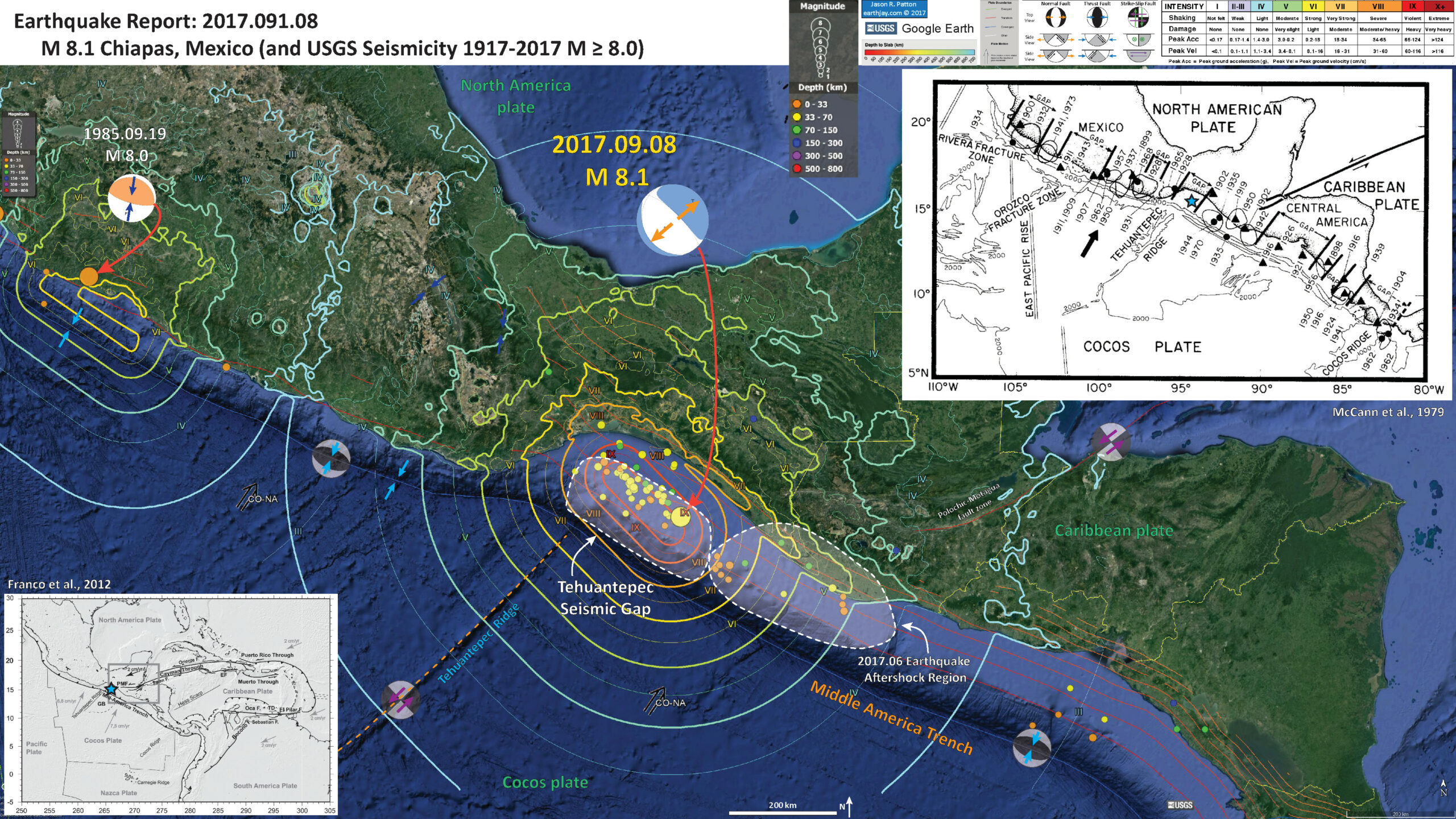
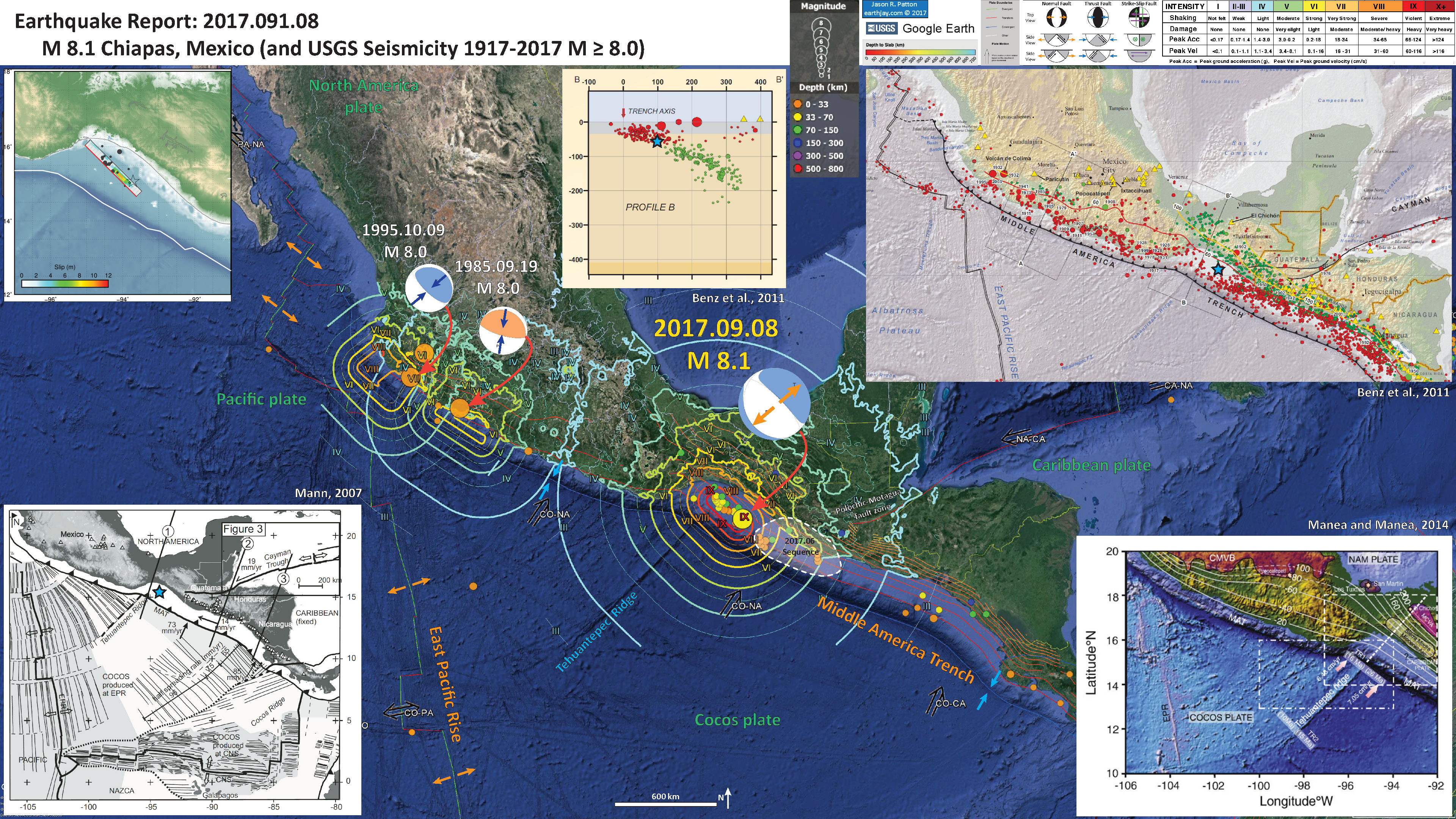
Below is my interpretive poster for this earthquake
I plot the seismicity from the past month, with color representing depth and diameter representing magnitude (see legend). I also include USGS epicenters from 1917-2017 for magnitudes M ≥ 8.0. I include fault plane solutions for the 1985 earthquake (along with the MMI contours for that earthquake, see below for a discussion of MMI contours).
I outline the region of seismicity from June 2017. I include posters and links to the reports from that sequence below.
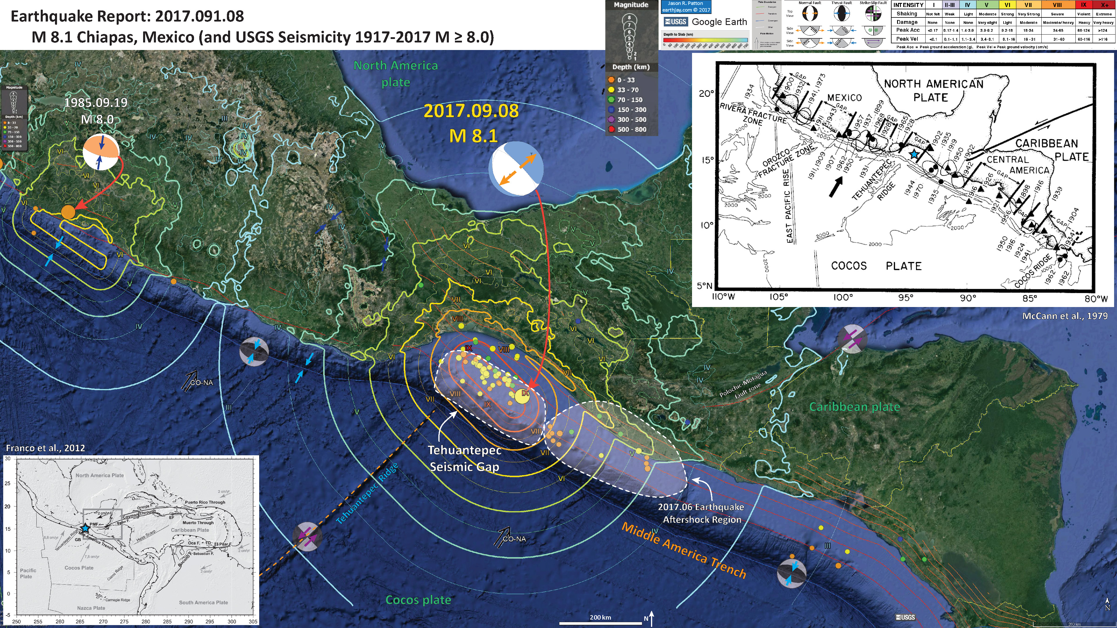
I also outline the region of the megathrust where the Tehuantepec Seismic Gap is located, generally in the region of the M 7.8 1902 megathrust earthquake. The Tehuantepec Ridge is a player in the regional tectonics as I discussed on my report earlier today.
- I placed a moment tensor / focal mechanism legend on the poster. There is more material from the USGS web sites about moment tensors and focal mechanisms (the beach ball symbols). Both moment tensors and focal mechanisms are solutions to seismologic data that reveal two possible interpretations for fault orientation and sense of motion. One must use other information, like the regional tectonics, to interpret which of the two possibilities is more likely.
- I also include the shaking intensity contours on the map. These use the Modified Mercalli Intensity Scale (MMI; see the legend on the map). This is based upon a computer model estimate of ground motions, different from the “Did You Feel It?” estimate of ground motions that is actually based on real observations. The MMI is a qualitative measure of shaking intensity. More on the MMI scale can be found here and here. This is based upon a computer model estimate of ground motions, different from the “Did You Feel It?” estimate of ground motions that is actually based on real observations. Note how much larger the MMI intensity is for this earthquake, compared to the 1985 and 1995 earthquakes.
- I include the slab contours plotted (Hayes et al., 2012), which are contours that represent the depth to the subduction zone fault. These are mostly based upon seismicity. The depths of the earthquakes have considerable error and do not all occur along the subduction zone faults, so these slab contours are simply the best estimate for the location of the fault.
- In the lower left corner is a figure from Franco et al. (2012) that shows the tectonic plate boundaries in this region. I place a blue star in the general location of this M 8.1 earthquake (as below).
- In the upper right corner is a figure from McCann et al. (1979) showing the major subduction zone earthquakes associated with the subduction zone that forms the Middle America Trench. This is the first (?) acknowledgement for the potential of a seismic gap in the region of today’s M 8.1 earthquake.
I include some inset figures in the poster.
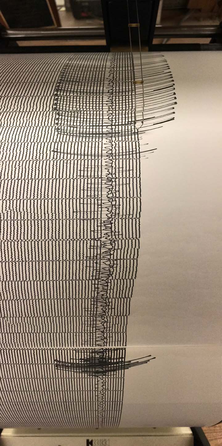
- Here are two views of the earthquake as recorded on Humboldt State University Department of Geology’s Baby Benioff seismometer. The photos are from Dr. Lori Dengler and were taken in the hallway in Van Matre Hall. Click on the image for a high res version (2 and 5 MB files).
- Here is the Franco et al. (2012) tectonic map.
Tectonic setting of the Caribbean Plate. Grey rectangle shows study area of Fig. 2. Faults are mostly from Feuillet et al. (2002). PMF, Polochic–Motagua faults; EF, Enriquillo Fault; TD, Trinidad Fault; GB, Guatemala Basin. Topography and bathymetry are from Shuttle Radar Topography Mission (Farr&Kobrick 2000) and Smith & Sandwell (1997), respectively. Plate velocities relative to Caribbean Plate are from Nuvel1 (DeMets et al. 1990) for Cocos Plate, DeMets et al. (2000) for North America Plate and Weber et al. (2001) for South America Plate.
- This is an update of the tide gage record at Salina Cruz in Oahaca, Mexico. It has been 15 hours and the tsunami waves are still significant (not as large amplitude as the initial few waves, but still potentially dangerous).
- Here is the McCann et al. (1979) summary figure.
Rupture zones (ellipses) and epicenters (triangles and circles) of large shallow earthquakes (after KELLEHER et al., 1973) and bathymetry (CHASE et al., 1970) along the Middle America arc. Note that six gaps which have earthquake histories have not ruptured for 40 years or more. In contrast, the gap near the intersection of the Tehuantepec ridge has no known history of large shocks. Contours are in fathoms.
- This is a more updated figure from Franco et al. (2005) showing the seismic gap.
- In 1902, there was an M 7.8 earthquake in the same region as tonight’s M 8.1. Here is a map from Franco et al. (2015) that shows the rupture patches for historic earthquakes in this region.
The study area encompasses Guerrero and Oaxaca states of Mexico. Shaded ellipse-like areas annotated with the years are rupture areas of the most recent major thrust earthquakes (M≥6.5) in the Mexican subduction zone. Triangles show locations of permanent GPS stations. Small hexagons indicate campaign GPS sites. Arrows are the Cocos-North America convergence vectors from NUVEL-1A model (DeMets et al., 1994). Double head arrow shows the extent of the Guerrero seismic gap. Solid and dashed curves annotated with negative numbers show the depth in km down to the surface of subducting Cocos plate (modified from Pardo and Su´arez, 1995, using the plate interface configuration model for the Central Oaxaca from this study, the model for Guerrero from Kostoglodov et al. (1996), and the last seismological estimates in Chiapas by Bravo et al. (2004). MAT, Middle America trench.
- Here is a cross section showing focal mechanisms for this region, prepared by Dr. Mike Brudzinski.
- Below are a map and cross section showing focal mechanisms for this region from Dr. Jascha Polet.
- Late breaking update from Jascha. Dr. Polet plotted the aftershocks to find that there is a clear NW rupture trend. Dr. Polet also points out that the aftershocks are in a narrow band, suggesting a steeply dipping fault. Also, they suggest that this is a short rupture (length ~200km) for a M 8.1 earthquake.
- Here is a great audio video representation of the seismic record from Hurricane Irma and this M 8.1 earthquake from Zhigang Peng.
- Here is a seismic record from Dr. Anthony Lomax.
- Here are a couple visualizations of the seismic waves as they propagate through the seismic network. These animations are produced by IRIS here.
- Here is a figure from Lay et al, (2011) that shows how stresses change on various types of faults given slip on the megathrust. A very simplistic way of applying this to today’s scenario would be that instead of an increasted stress on normal faults imparted by the megathrust earthquake (as in Japan), that there may be an increased coulomb stress on the megathrust imparted by the normal fault earthquake (as in Mexico). This is pure arm waving (as one would expect from a geologist), but I hope that someone does the analysis soon. I suspect that Tremblor.com will have something on this very soon.
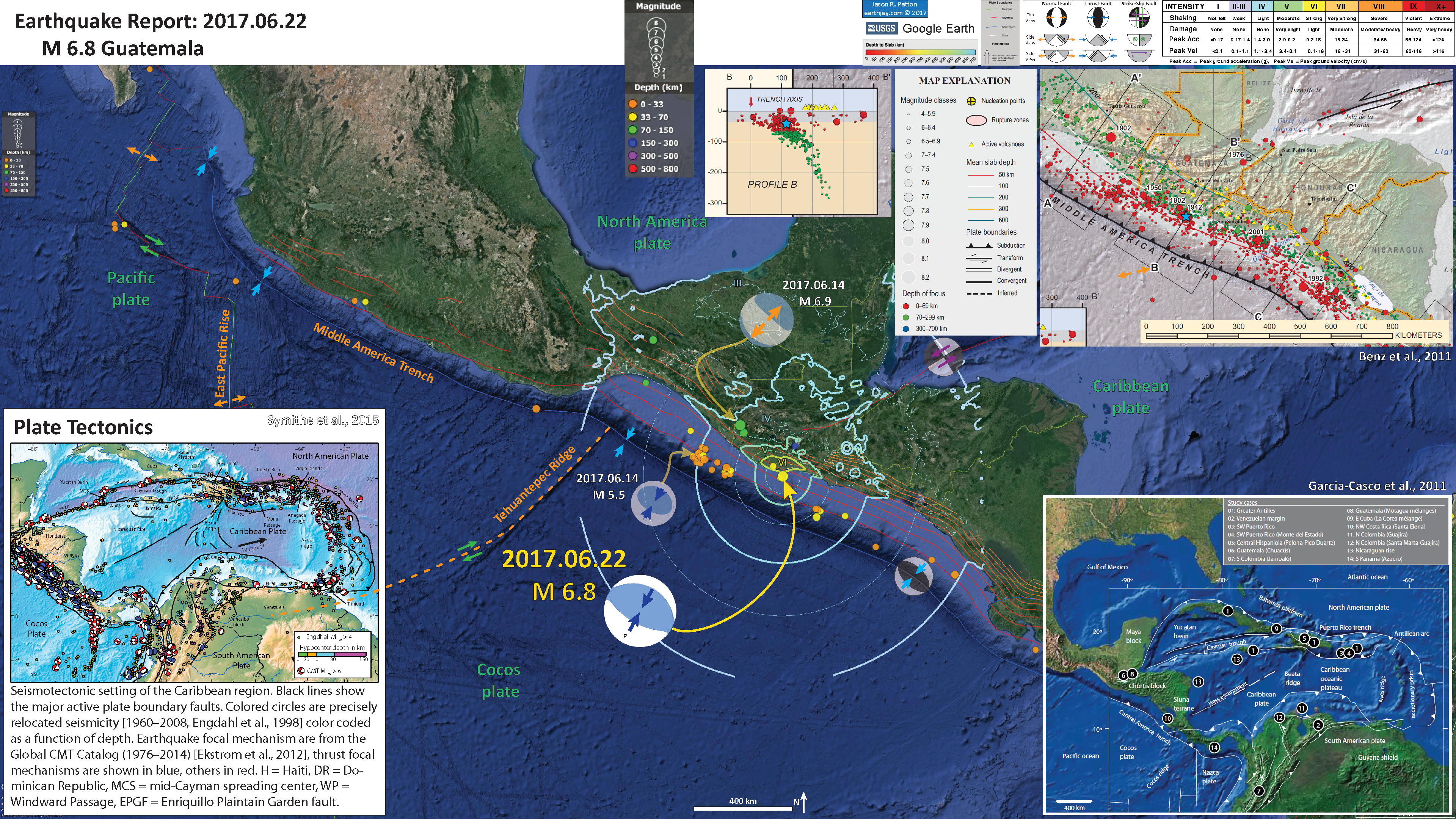
- Here is the interpretive poster from the recent earthquakes in Guatemala. This is my report for this earthquake.
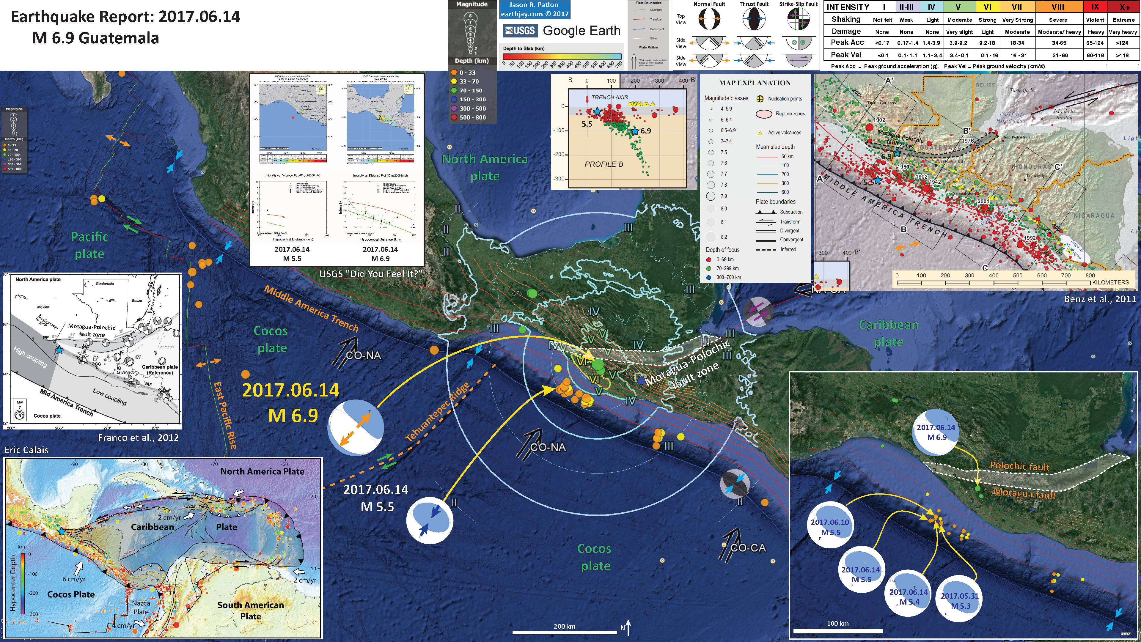
- This is also from this sequence, but includes some other inset figures. From this report.
- 2017.09.08 M 8.1 Chiapas, Mexico
- 2017.09.08 M 8.1 Chiapas, Mexico Update #1
- 2017.06.22 M 6.8 Guatemala
- 2017.06.14 M 6.9 Guatemala
- 2017.05.12 M 6.2 El Salvador
- 2017.03.29 M 5.7 Gulf of California
- 2016.11.24 M 7.0 El Salvador
- 2016.04.29 M 6.6 East Pacific Rise / MAT
- 2016.01.21 M 6.6 Mexico
- 2015.09.13 M 6.6 Gulf California
- 2015.09.13 M 6.6 Gulf California Update #1
- 2014.10.14 M 7.3 El Salvador
- 2013.10.20 M 6.4 Gulf California
Seismicity: Mexico | Central America
General Overview
Earthquake Reports
References:
- Benz, H.M., Dart, R.L., Villaseñor, Antonio, Hayes, G.P., Tarr, A.C., Furlong, K.P., and Rhea, Susan, 2011 a. Seismicity of the Earth 1900–2010 Mexico and vicinity: U.S. Geological Survey Open-File Report 2010–1083-F, scale 1:8,000,000.
- Benz, H.M., Tarr, A.C., Hayes, G.P., Villaseñor, Antonio, Furlong, K.P., Dart, R.L., and Rhea, Susan, 2011 b. Seismicity of the Earth 1900–2010 Caribbean plate and vicinity: U.S. Geological Survey Open-File Report 2010–1083-A, scale 1:8,000,000.
- Franco, A., C. Lasserre H. Lyon-Caen V. Kostoglodov E. Molina M. Guzman-Speziale D. Monterosso V. Robles C. Figueroa W. Amaya E. Barrier L. Chiquin S. Moran O. Flores J. Romero J. A. Santiago M. Manea V. C. Manea, 2012. Fault kinematics in northern Central America and coupling along the subduction interface of the Cocos Plate, from GPS data in Chiapas (Mexico), Guatemala and El Salvador in Geophysical Journal International., v. 189, no. 3, p. 1223-1236. DOI: https://doi.org/10.1111/j.1365-246X.2012.05390.x
- Franco, S.I., Kostoglodov, V., Larson, K.M., Manea, V.C>, Manea, M., and Santiago, J.A., 2005. Propagation of the 2001–2002 silent earthquake and interplate coupling in the Oaxaca subduction zone, Mexico in Earth Planets Space, v. 57., p. 973-985.
- Garcia-Casco, A., Projenza, J.A., Iturralde-Vinent, M.A., 2011. Subduction Zones of the Caribbean: the sedimentary, magmatic, metamorphic and ore-deposit records UNESCO/iugs igcp Project 546 Subduction Zones of the Caribbean in Geologica Acta, v. 9, no., 3-4, p. 217-224
- Hayes, G. P., D. J. Wald, and R. L. Johnson, 2012. Slab1.0: A three-dimensional model of global subduction zone geometries, J. Geophys. Res., 117, B01302, doi:10.1029/2011JB008524.
- Lay et al., 2011. Outer trench-slope faulting and the 2011 Mw 9.0 off the Pacific coast of Tohoku Earthquake in Earth Planets Space, v. 63, p. 713-718.
- Manea, M., and Manea, V.C., 2014. On the origin of El Chichón volcano and subduction of Tehuantepec Ridge: A geodynamical perspective in JGVR, v. 175, p. 459-471.
- Mann, P., 2007, Overview of the tectonic history of northern Central America, in Mann, P., ed., Geologic and tectonic development of the Caribbean plate boundary in northern Central America: Geological Society of America Special Paper 428, p. 1–19, doi: 10.1130/2007.2428(01). For
- McCann, W.R., Nishenko S.P., Sykes, L.R., and Krause, J., 1979. Seismic Gaps and Plate Tectonics” Seismic Potential for Major Boundaries in Pageoph, v. 117
- Symithe, S., E. Calais, J. B. de Chabalier, R. Robertson, and M. Higgins, 2015. Current block motions and strain accumulation on active faults in the Caribbean in J. Geophys. Res. Solid Earth, v. 120, p. 3748–3774, doi:10.1002/2014JB011779.



NOTICE ALL THE EPICENTERS ….CENTER,,,,…….THE ORIGIN OF THE QUAKE…….THE EXACT PLACE WHERE IT SHOOK THE EARTH….
WAS ON THE COAST LINE.
ON TH E COAST LINE.
QUESTION: DID NORTH KOREA DETONATE A NUKE UNDERWATER
TO PUNISH MEXICO FOR STOPPING TO SEND FUEL AND SUPPLIES?
DID YOU CONFIRM THAT IS WAS NATURE?
OR WAS IT AN UNDER WATER ATTACK?
The earthquake was natural.
Sept 18, 2017
Do we need to be concerned with the recent activity in Idaho, Yellowstone?
What about the activity on the west coast, California, Oregon, Washington?
I live in Utah in Eagle Mountain.
Where can I find the fault lines where I live?
Thank you so much for your research and maps and everything you have posted! It is amazing!
ps.what do you think about Russia’s earthquakes?
Please forgive the delay. We do not need to be concerned about the earthquakes in Mexico as they do not affect the chance for an earthquake in the USA.
You live near the Wasatch fault system, which is at the base of the Wasatch range to your east. More can be found here:
https://geology.utah.gov/hazards/earthquakes-faults/utah-faults/
I encourage you to get involved in the Utah Shakeout! More on this is here: https://www.shakeout.org/utah/scenarios/