
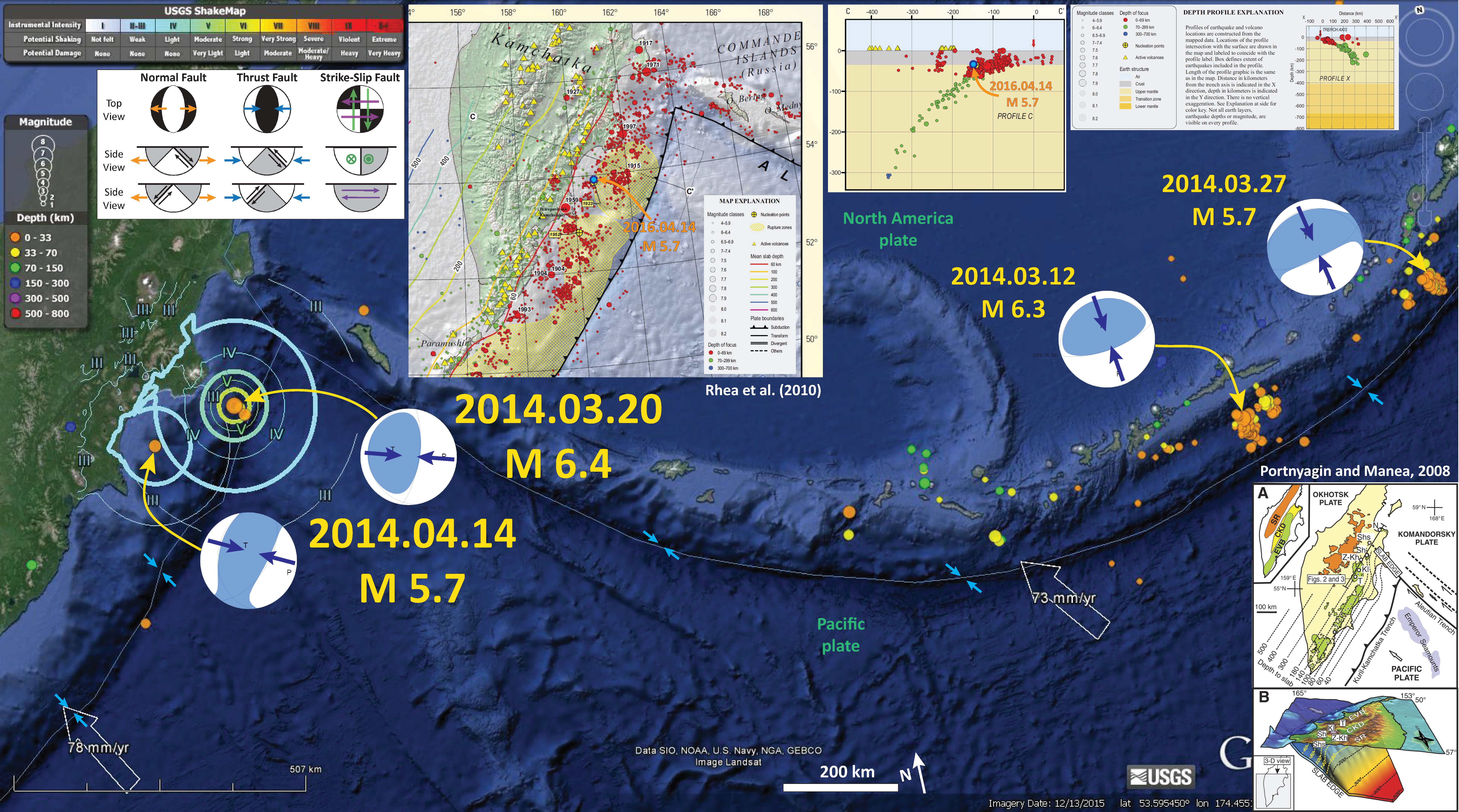
A couple weeks ago, there was an earthquake with a magnitude of M 6.4 and today there was an earthquake with a magnitude of M 5.7. I had not put together a report for the M 6.4, so this report serves both earthquakes.
Below is a the earthquake poster. I include seismicity from the last month, moment tensors from the Kamchatka earthquakes listed above, moment tensors for two representative earthquakes along the Aleutian trench, and some other figures.
I also plot the Modified Mercalli Intensity contours for the Kamchatka earthquakes. The MMI scale is a qualitative scale of the ground motions. There is more about the MMI here.
I placed a moment tensor / focal mechanism legend on the poster. There is more material from the USGS web sites about moment tensors and focal mechanisms (the beach ball symbols). Both moment tensors and focal mechanisms are solutions to seismologic data that reveal two possible interpretations for fault orientation and sense of motion. One must use other information, like the regional tectonics, to interpret which of the two possibilities is more likely.
-
I have included a few inset maps.
- Along the top of the poster I include a map and cross section from the USGS Open File report (Rhea et al., 2010) that explains the historic seismicity for this region. I also plot the epicenter (blue dot) on the map and the hypocenter (blue dot) on the cross section. These are approximate locations and show that this M 5.78 earthquake plot very close to the location of the 1923.02.03 M 8.4 earthquake.
- In the lower right corner, I include a figure from Portnyagin and Manea (2008 ) that shows a low angle oblique view of the downgoing Pacific plate slab. I post this figure and their figure caption below.
-
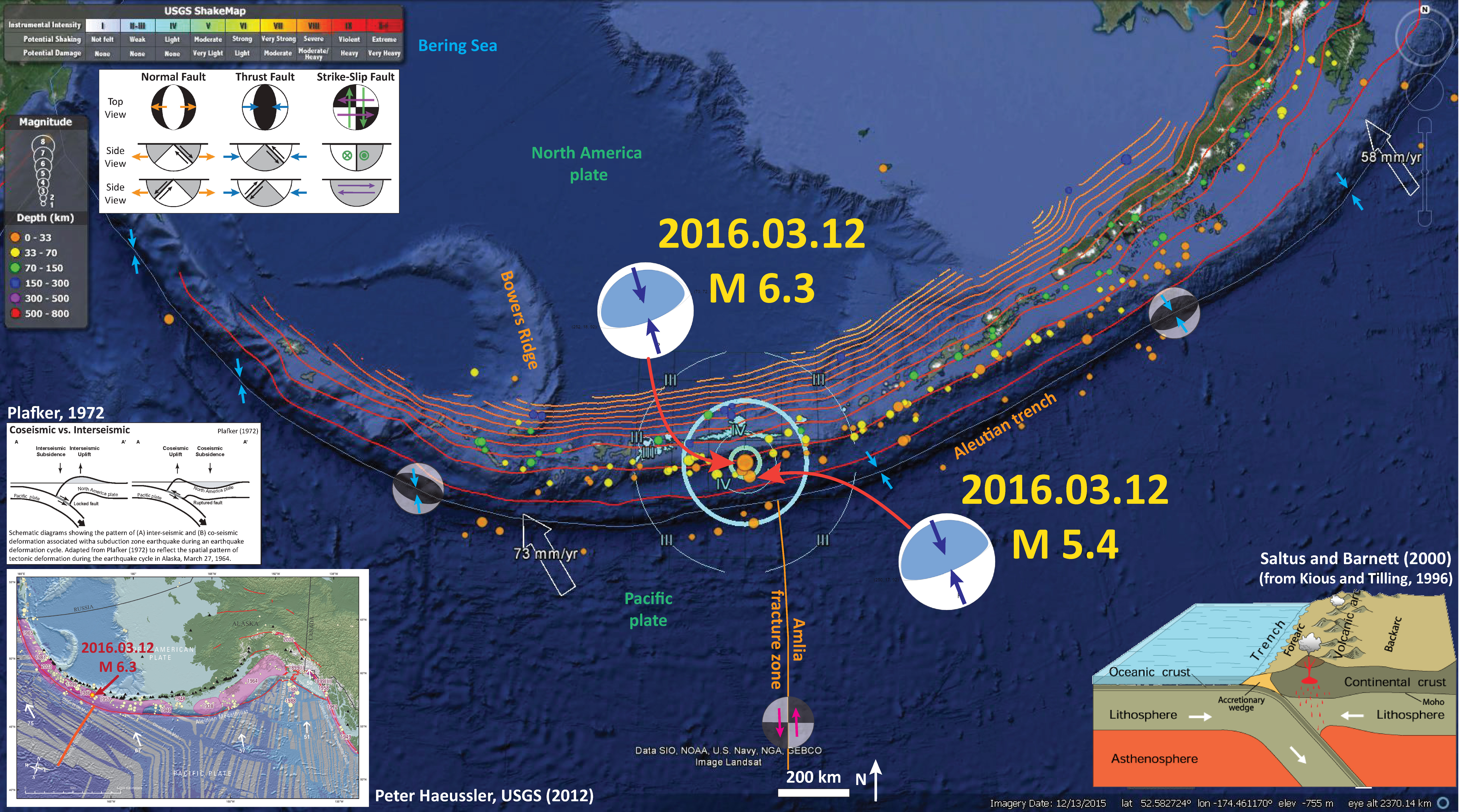
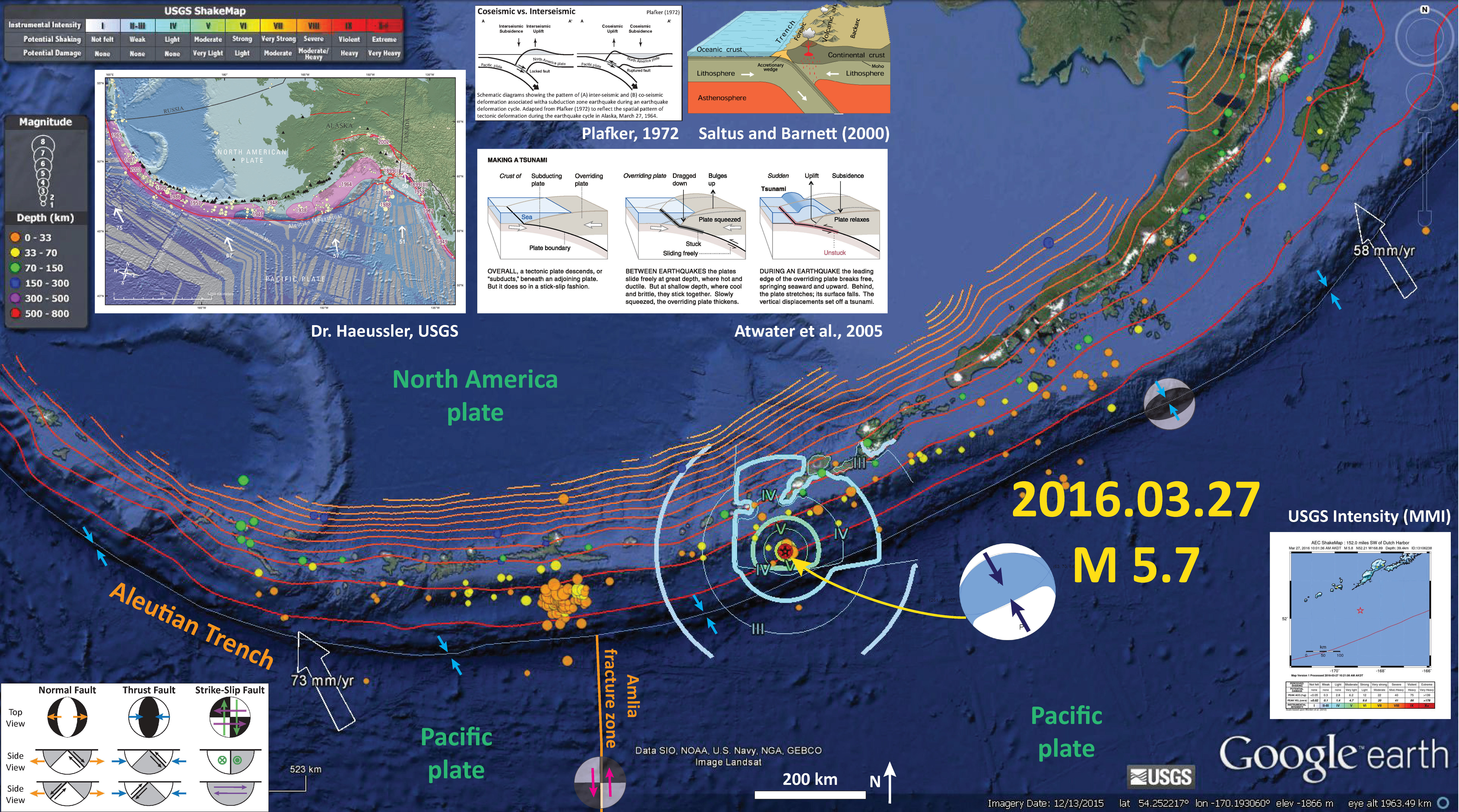
Here are my Earthquake Reports for the Aleutian trench earthquakes in March, 2016.
- 2014.03.12 M 6.3 first report
- 2014.03.19 M 6.3 second report
- 2014.03.27 M 5.7 first report
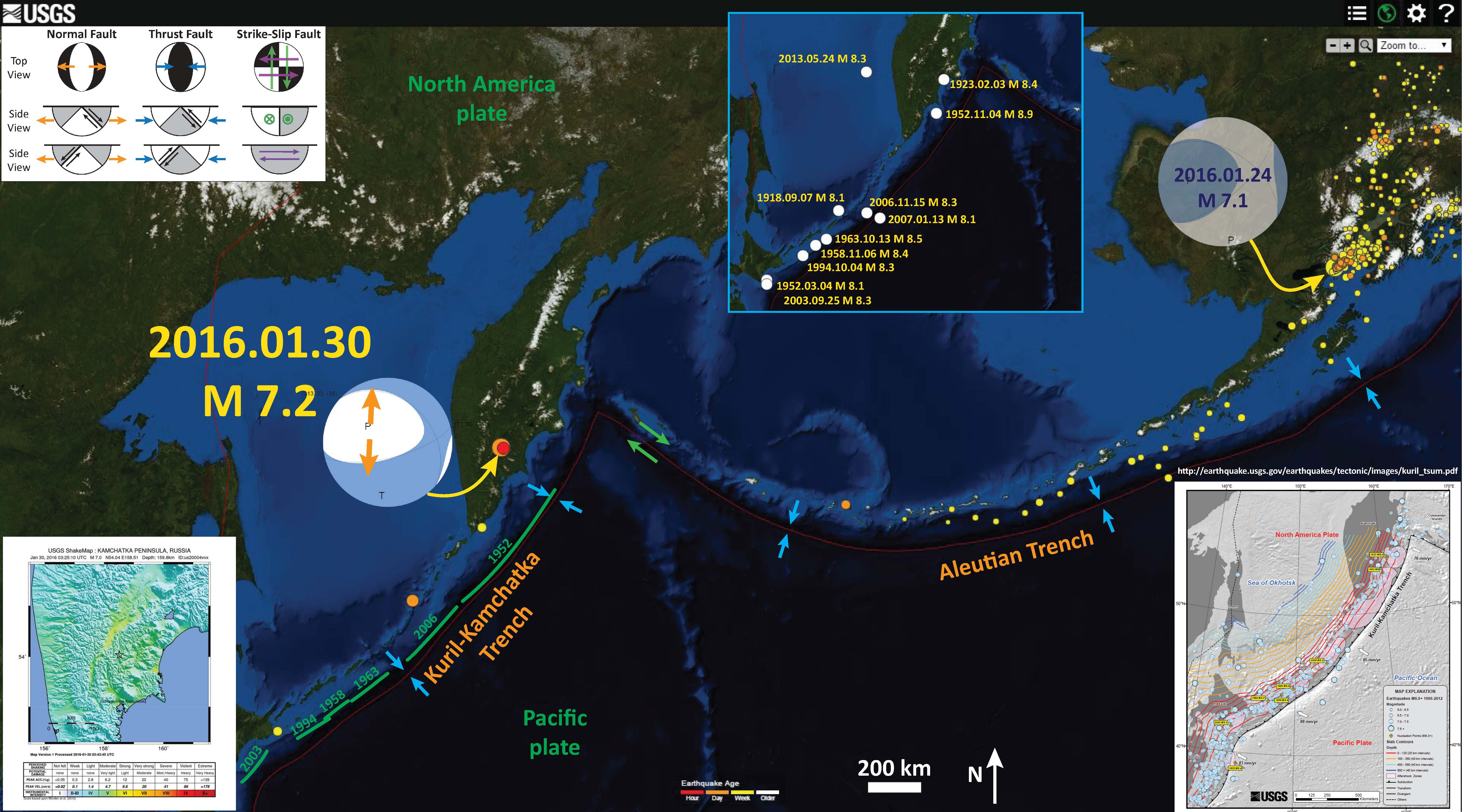
- 2016.01.30 M 7.2
Here is my Earthquake Report for an earthquake with a magnitude of M 7.2 in Kamchatka on 2016.01.30. The earthquakes plotted above may be related to this M 7.2 earthquake.
This is the Earthquake Report Poster from the 2016.01.30 M 7.2 Kamchatka earthquake.
This is the Earthquake Report Poster from the 2016.03.12 M 6.3 Aleutian trench earthquake.
This is the Earthquake Report Poster from the 2016.03.27 M 5.7 Aleutian trench earthquake.
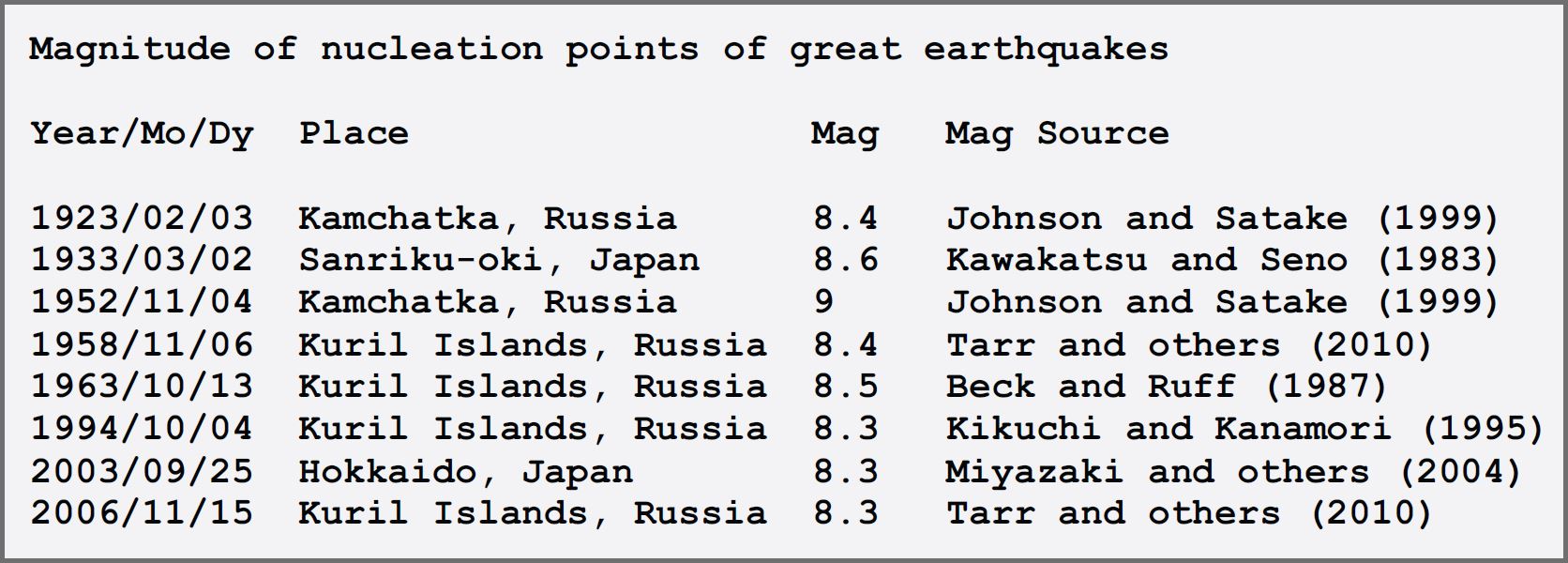
Here is a list of earthquakes plotted on the USGS OFR poster (Rhea et al., 2010). Note the 1923 earthquake.
Here is the low-angle oblique map from Portnyagin and Manea (2008). I include the figure caption as a blockquote below.
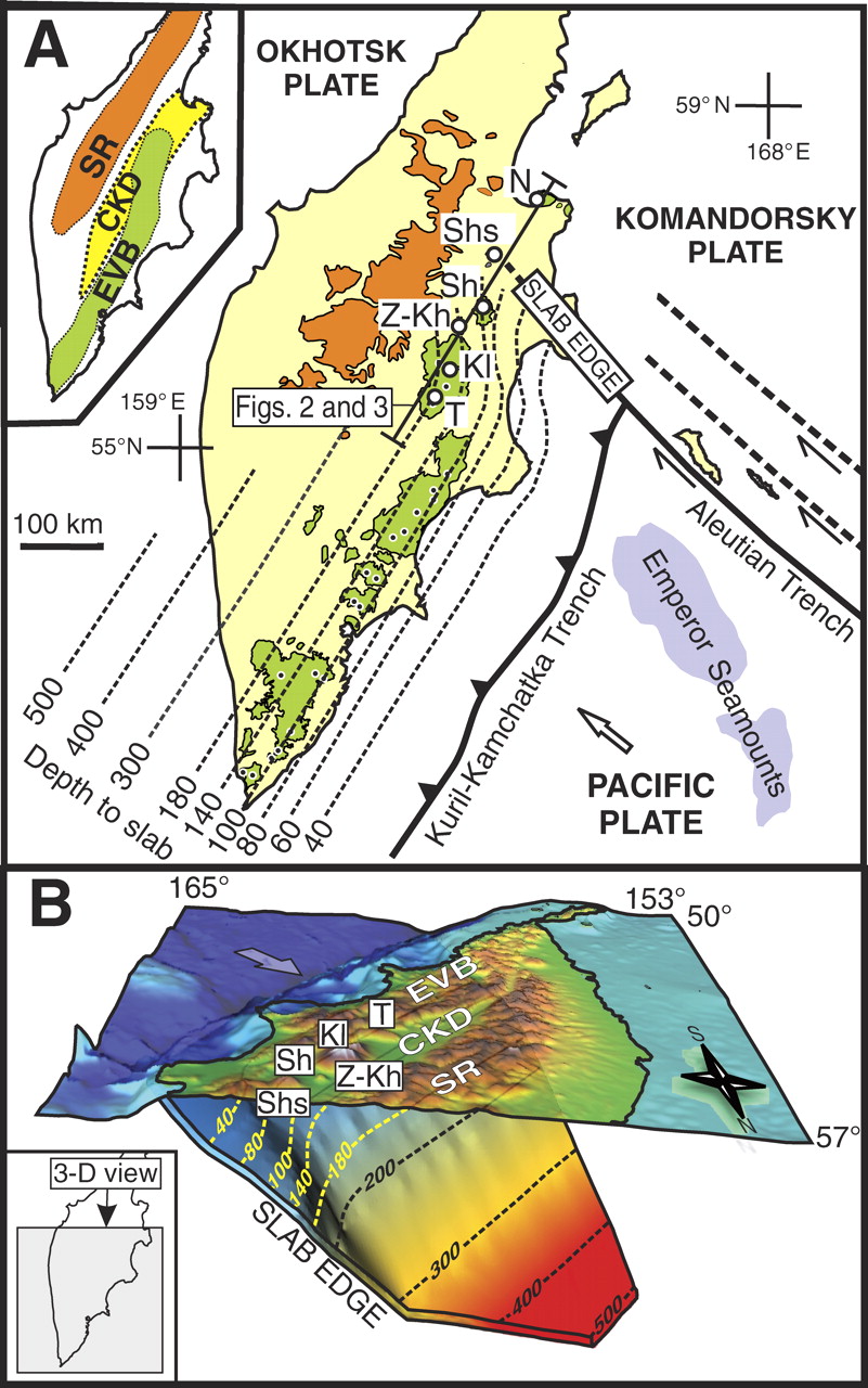
Kamchatka subduction zone. A: Major geologic structures at the Kamchatka–Aleutian Arc junction. Thin dashed lines show isodepths to subducting Pacific plate (Gorbatov et al., 1997). Inset illustrates major volcanic zones in Kamchatka: EVB—Eastern Volcanic Belt; CKD—Central Kamchatka Depression (rift-like tectonic structure, which accommodates the northern end of EVB); SR—Sredinny Range. Distribution of Quater nary volcanic rocks in EVB and SR is shown in orange and green, respectively. Small dots are active vol canoes. Large circles denote CKD volcanoes: T—Tolbachik; K l — K l y u c h e v s k o y ; Z—Zarechny; Kh—Kharchinsky; Sh—Shiveluch; Shs—Shisheisky Complex; N—Nachikinsky. Location of profiles shown in Figures 2 and 3 is indicated. B: Three dimensional visualization of the Kamchatka subduction zone from the north. Surface relief is shown as semi-transparent layer. Labeled dashed lines and color (blue to red) gradation of subducting plate denote depths to the plate from the earth surface (in km). Bold arrow shows direction of Pacific Plate movement.
-
References:
- Portnyagin, M. and Manea, V.C., 2008. Mantle temperature control on composition of arc magmas along the Central Kamchatka Depression in Geology, v. 36, no. 7, p. 519-522.
- Rhea, Susan, Tarr, A.C., Hayes, Gavin, Villaseñor, Antonio, Furlong, K.P., and Benz, H.M., 2010, Seismicity of the earth 1900–2007, Kuril-Kamchatka arc and vicinity: U.S. Geological Survey Open-File Report 2010–1083-C, scale 1:5,000,000.
1 thought on “Earthquake Report: Kamchatka!”