
A couple days ago, I was on the road and did not yet have my laptop. Therefore I am reporting about this earthquake a few days afterwards…
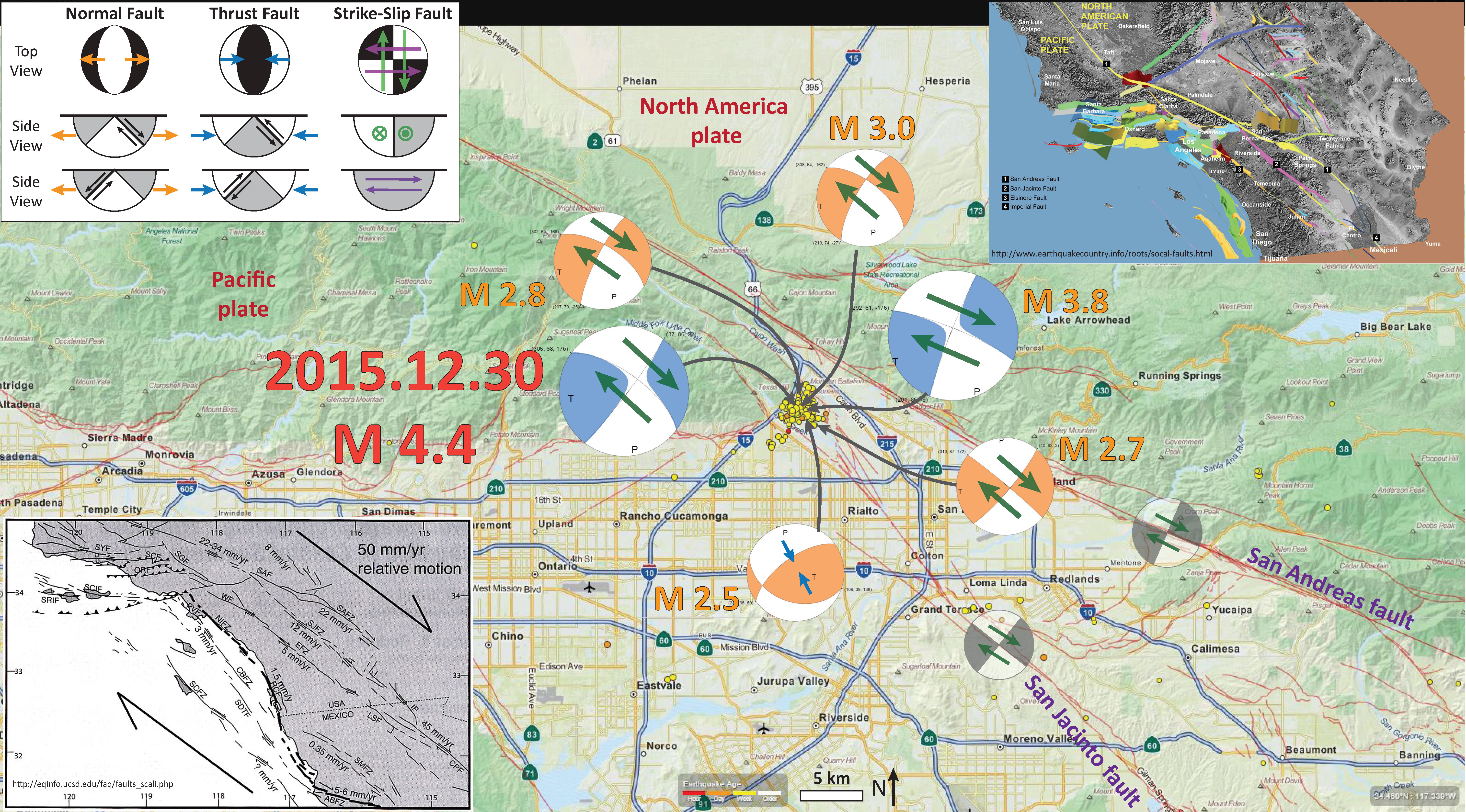
There has been a swarm of seismic activity in the San Bernardino area. I actually drove along Lone Pine Canyon Road on my way to visit my family for the holidays. The San Andreas fault rips through (forms) the canyon through which this road traverses. Once on the 15, I drove within a few hundred meters of the epicenter of the largest magnitude earthquake from this series, a M 4.4 earthquake. Below I list the USGS web sites for the earthquakes of largest magnitude.
- 2015.12.30 M 4.4
- 2015.12.30 M 3.8
- 2015.12.30 M 3.0
- 2015.12.30 M 2.8
- 2015.12.30 M 2.7
- 2015.12.30 M 2.5
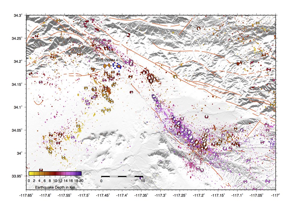
Below is a map that shows the epicenters for earthquakes from the past week. I also place moment tensors (in blue) and focal mechanisms (orange) for the largest earthquakes (listed above). I also include a few inset maps. The lower left map is from Grant and Rockwell (2002) and shows how the Pacific-North America relative plate motion of 50 mm/yr is distributed across various fault systems. The San Andreas fault accommodates ~22 mm/yr and the San Jacinto fault accommodates ~12 mm/yr. The map in the upper right corner is from the Southern California Earthquake Center and shows the geometrical relations between the various major crustal faults in southern California.
I placed a moment tensor / focal mechanism legend in the upper left corner of the map. There is more material from the USGS web sites about moment tensors and focal mechanisms (the beach ball symbols). Both moment tensors and focal mechanisms are solutions to seismologic data that reveal two possible interpretations for fault orientation and sense of motion. One must use other information, like the regional tectonics, to interpret which of the two possibilities is more likely.
Presuming that these earthquakes are occurring on a fault synthetic to the San Jacinto fault, I interpret these earthquakes to have NW striking right-lateral strike-slip fault plane solutions. There is one earthquake that shows a compressional solution.
In March 2014 there was a M 5.1 earthquake to the southwest of this swarm, near La Habra. I posted earthquake reports on 2014.03.28 and 2014.03.29.
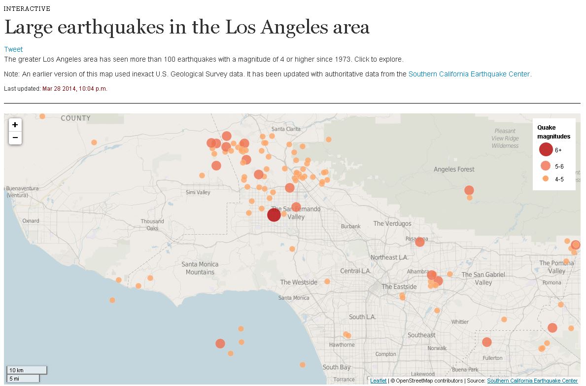
Here is an interactive map from the LA Times that shows the historic earthquakes in LA.
Here is the Grant and Rockwell (2002) map alone. I include the caption below as a blockquote.
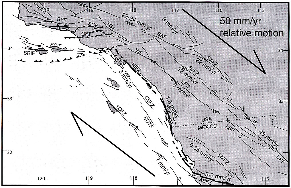
Faults are annotated with geologically measured slip rates where available. Major faults include the San Andreas Fault and zone (SAF and SAFZ), San Jacinto Fault zone (SJFZ), Elsinore Fault zone (EFZ), Whittier Fault (WF), Palos Verdes Fault (PVF), Newport-Inglewood Fault Zone (NIFZ), Rose Canyon Fault (RCF), Agua Blanca Fault zone (ABFZ), San Miguel Fault zone (SMFZ), Imperial Fault (IF), Cerro Prieto (CPF), and Laguna Salada Fault (LSF). Offshore faults include the Coronado Bank Fault zone (CBFZ), San Diego Trough Fault (SDTF), San Clemente Fault zone (SCFZ), Santa Cruz Island Fault (SCIF), and Santa Rosa Island Fault (SRIF). The San Gabriel Fault (SGF), San Cayetano Fault (SCF), Oak Ridge Fault (ORF), and Santa Ynez Fault (SYF) are located in the Transverse Ranges.
Here is that SCEC map alone. I include the caption below as a blockquote.
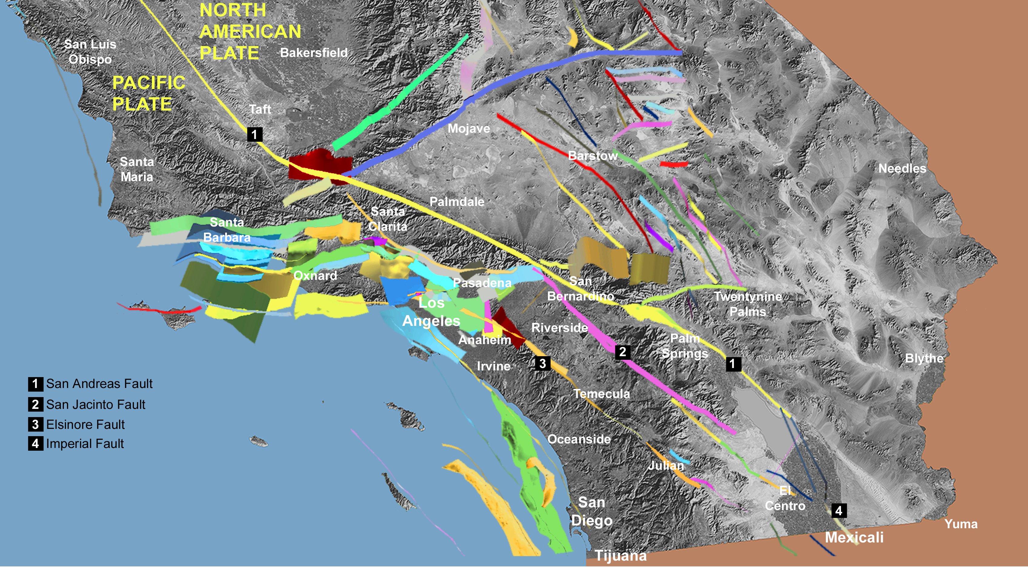
SCEC Community Fault Model. This map shows the 3-dimensional structure of major faults beneath Southern California. Vertical faults such as the San Andreas (yellow band from top left to bottom right) are shown as a thin strip. Faults that are at an angle to the surface are shown as wider ribbons of color. The nearest fault to you might be a few miles beneath your home. Areas that seem to have few faults can still experience strong shaking from earthquakes on unmapped faults or from large earthquakes on distant faults.
Here is an animation from the Southern California Earthquake Center that shows earthquake hypocenters in relation the SCEC fault model. Here is a link to the embedded video below (24 MB mp4).
Here is a map from Jacha Polet, Professor of Geophysics at Cal Poly Pomona.
-
References:
- Grant, L. B. and Rockwell, T. K., 2002. A Northward-propagting Earthquake Sequence in Coastal Southern California? Seismological Research Letters, Volume 73, Number 4, pp. 461 – 469.