Here are a couple of videos that document the arrival of tsunami waves in the “mouth of Genio river at Wafer Bay, Cocos Island, Costa Rica.
Cocos Island is a National Park located between Galapagos Islands and the continental coast of Costa Rica, at a distance of about 500km of the later.” (quote from Dr. Silvia Chacón-Barrantes Coordinator RONMAC Program (Costa Rica Sea Level Observation Network); Coordinator SINAMOT (National Tsunami Monitoring System); National University (UNA); Heredia, Costa Rica; silviachaconb at gmail.com )
-
Here are my original posts about the earthquake:
- 2015.09.16 M 8.3 first post
- 2015.09.16 M 8.3 first update
Here is the video link to youtube of the embedded video below.
Here is an mp4 file to download.
Here is an example of the 2011 tsunami in the same location. The youtube link of the embedded video below.
Here are some observations of the tsunami on the west coast of the USA. These are from NOAA.
Crescent City:
(updated 2015.09.17 20:20 PST)

The North Spit (Humboldt Bay):

Ventura, California:

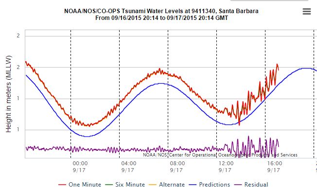
Santa Barbara, California:
(updated 2015.09.17 20:20 PST)


Here are some observations as reported by NOAA.

And, here are some hourly GPS observations of this earthquake, processed at the Nevada Geodetic Laboratory. This was posted by Dr. John Vidale of the Pacific Northwest Seismic Network. Here is John’s quote of Geoff,
“From Geoff Blewitt, UNR, realtime GPS of the Chile earthquake:
“a figure showing our 5-minute GPS solutions for station SANT, Santiago, Chile. The earthquake displaced the station over approximately 10 mm northward, and 15 mm westward. It will be interesting to see retrospectively how real time GPS performed.”
Slightly non-realtime – automatically updated every hour, but I don’t think that matters.”

6 thoughts on “Chile M 8.3 Earthquake: Tsunami Observations!”