Well, I am a little late preparing this report. I actually put it together over the weekend, but am only now uploading this.
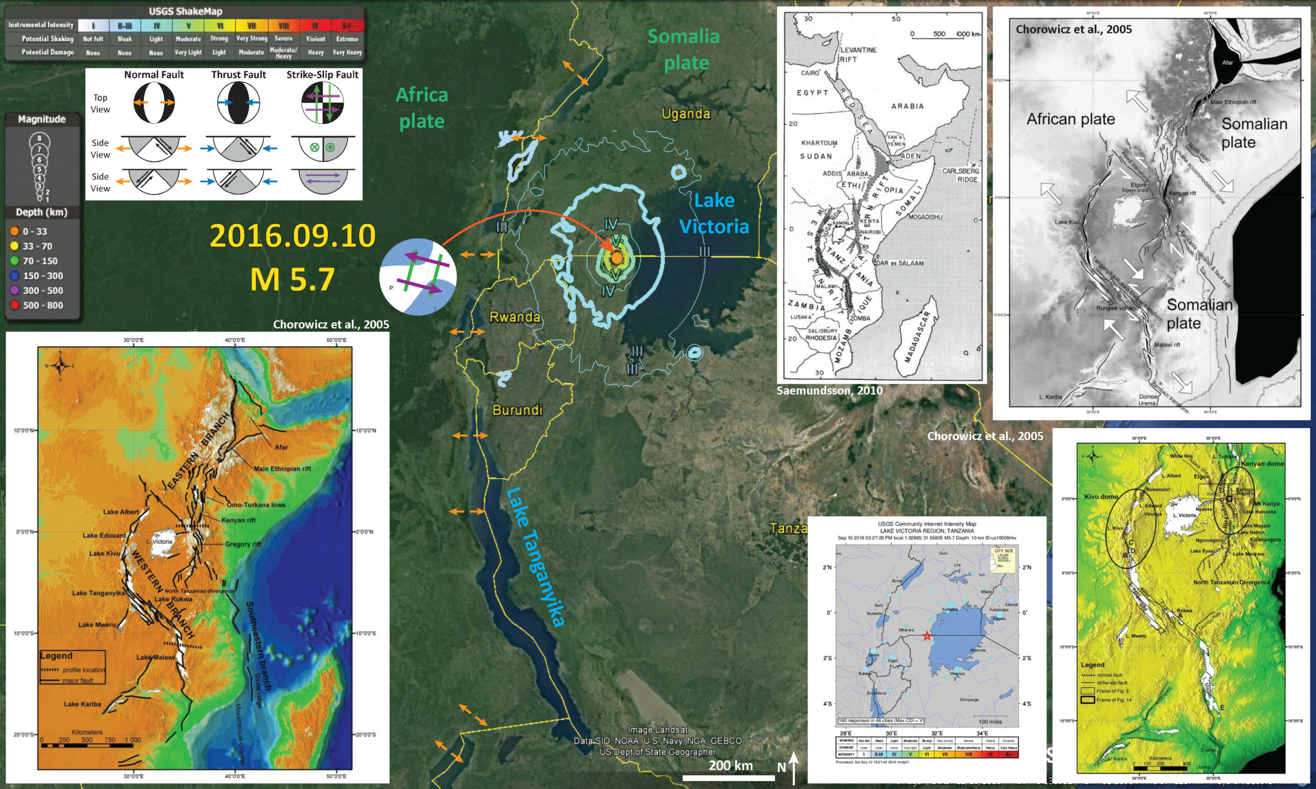
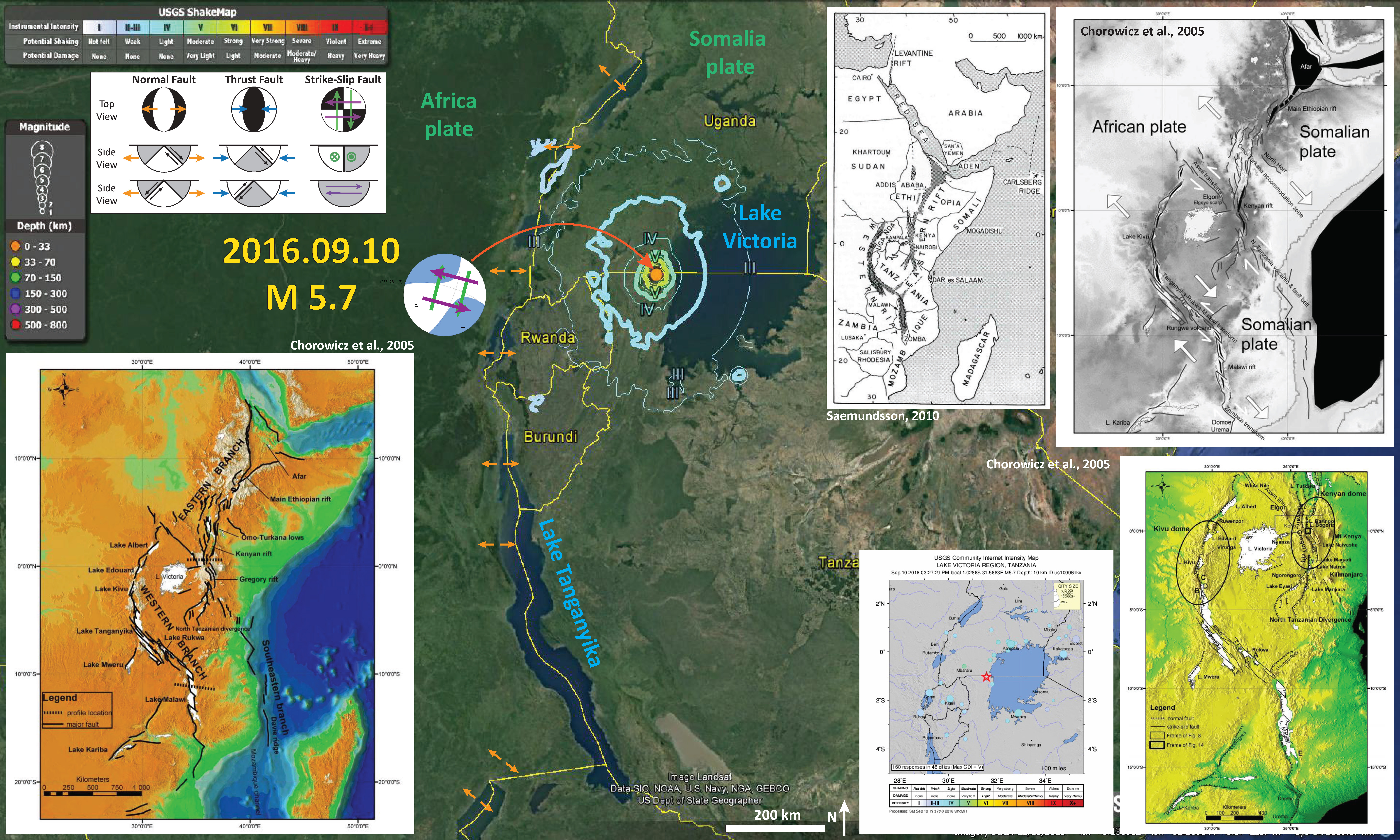
There was an interesting earthquake along the southwestern edge of Lake Victoria, in the East-Africa Rift (EAR) system. The EAR is one of the few continental rift systems on Earth. We think that continental rift systems are early in the development of an oceanic spreading ridge system. This may be what the Mid Atlantic Ridge system looked like long ago. There are no mapped faults in this region (at least in the papers that I found on the subject). On 2016.09.10, there was a M 5.9 earthquake and here is the USGS website for this earthquake. My poster below shows it as a M 5.7, but the magnitude has been adjusted to M 5.9.
Below is my interpretive map that shows the epicenter, along with the shaking intensity contours. These contours use the Modified Mercalli Intensity (MMI) scale. The MMI is a qualitative measure of shaking intensity. More on the MMI scale can be found here and here. This is based upon a computer model estimate of ground motions, different from the “Did You Feel It?” estimate of ground motions that is actually based on real observations.
I placed a moment tensor / focal mechanism legend on the poster. There is more material from the USGS web sites about moment tensors and focal mechanisms (the beach ball symbols). Both moment tensors and focal mechanisms are solutions to seismologic data that reveal two possible interpretations for fault orientation and sense of motion. One must use other information, like the regional tectonics, to interpret which of the two possibilities is more likely. Because there are no mapped faults to give me a clue as to which slip plane this earthquake may have occurred on, it is equivocal. However, the faults to the west, which are mapped as normal (extensional) faults, may have some strike-slip faults associated with them. If this earthquake is related in that way, the right-lateral shear across the plate boundary here would suggest that this M 5.9 earthquake was along a north-south striking fault, with a right-lateral sense of motion.
-
I include some inset figures.
- In the lower left corner I include a map that shows the general location of the major fault segments in the EAR. These are named as per Chorowicz (2005).
- In the upper right corner, I include another figure from Chorowicz (2005). This shows how the faults are accommodating the regional tectonic strain.
- To the left of that figure is a regional tectonic figure showing the areas of the EAR that are dominated by extension (Saemundsson, 2010). These are separated into the western and eastern rifts.
- In the lower right corner, I include a fault map of the region from Chorowicz (2005). The symbology shows the fault types in the region (hatchured lines are normal or extensional faults; other faults are strike-slip faults).
- To the left of this map, is a map showing “Did You Feel It?” (DYFI) responses for this earthquake. Note how broadly the earthquake was felt.
-
Here are some of the figures on their own. I include the original figure captions below them as blockquotes.
- Regions of extension (Saemundsson, 2010).
- Fault segments along the EAR, Chorowicz (2005).
- Faults characterized vs. their major sense of motion, Chorowicz (2005).
- Regional tectonic strain, Chorowicz (2005).
- This is an illustration showing how the extension in this region may be accommodated by dextral (right-lateral) strike-slip faults, Chorowicz (2005).
The Afro-Arabian rift system (continental graben and depressions are shaded) (From: Baker et al., 1972)
Hypsographic DEM of the East African rift system. Black lines: main faults; E–W dotted lines: locations of cross-sections of Fig. 3; white surfaces: lakes; grey levels from dark (low elevations) to light (high elevations). The East African rift system is a series of several thousand kilometers long aligned successions of adjacent individual tectonic basins (rift valleys), separated from each other by relative shoals and generally bordered by uplifted shoulders. It can be regarded as an intra-continental ridge system comprising an axial rift.
Western branch and part of eastern branch of the East African rift system, on shadowed DEM.
On-going individualization of the Somalian plate in Eastern Africa. Asthenospheric intrusions (black polygons) show already open lithosphere. White arrows show direction of relative divergent movement.
Fault and fold zone of the Tanganyika–Rukwa–Malawi segment of the EARS. Folds are developed in stripes between left-stepping en echelon dextral strike-slip faults. This pattern of folds explains why some segment border areas of the Tanganyika rift form low plains instead of the usual high shoulders.
-
References
- Baker, B.H., Mohr P.A., and Williams, L.A.J., 1972: Geology of the Eastern Rift System of Africa in The Geol. Soc. of America. Special Paper, 136, 67 pp.
- Chorowicz, J., 2005. The East African rift system in Journal of African Earth Sciences, v. 43., p. 379-410.
- Saemundsson, K., 2010. East African Rift System – an Overview presented at Short Course V on Exploration for Geothermal Resources, organized by UNU-GTP, GDC and KenGen, at Lake Bogoria and Lake Naivasha, Kenya, Oct. 29 – Nov. 19, 2010, 10 pp.


We have developed a structural “Fault Block” model for Botswana and Zimbabwe for the purpose of mapping the Permo-Carboniferous Karoo coal measures. We have used all the geophysical, geological and tectonic information available for Botswana including a borehole data base of almost 1 500 exploration boreholes. Our model clearly shows that the Moijabana Earthquake in April 2017, is not related to the East African Rift System, but rather normal movement on a “Splay Fault” developed off the approximatey east-west trending Zoetfontein. This fault is clearly visible on the regional aeromagnetic survey map.