Good Morning!
A very coolio M 5.4 earthquake in the northern Indian Ocean between the Ninetyeast Ridge and Sri Lanka.
Here is the USGS webpage for this earthquake.
This is interesting because it is northwest of a swarm of earthquakes from 2012. In 2012, the two largest magnitude strike-slip earthquakes ever recorded occurred in the deep lithosphere west of the 2004/2005 Sumatra-Andaman subduction zone earthquakes. While the structural grain in the crust (as evidenced by fracture zone generated seafloor topography and offsets in magnetic anomalies and gravity anomalies) in this part of the India plate, these earthquakes ruptured west-northwest striking faults.
Here is my first page on the Sumatra outer rise earthquakes. Here is a follow up page, after there were some aftershocks.
Here is the M 5.4, all by its lonesome, in the northern Indian Ocean (the westernmost orange dot). Ignore the magenta line, it is plotting the wharton ridge in the incorrect location, which is not really a plate boundary anyways. Some day the USGS will update this kml file. We can see the recent Andaman Sea Swarm in the upper right corner of this map. The Andaman Sea is a region in the back arc, where there is extension related to spreading ridges.

Here is the same map, but with historic earthquakes plotted in grey circles. I have labeled the largest magnitude earthquakes with some names and magnitudes. I have outlined the epicenters of these larger magnitude earthquakes also.

Here I have placed a red line where some place the location of the faults that ruptured in April 2012.

I am here placing a map that is merely based on wild speculation. The M 5.4 earthquake aligns with the southern fault that ruptured in 2012. There are not many historic earthquakes in this region. Strain accumulated in the India plate in this region has been estimated based on offsets of earthquake faults… but this 5.4 probably did not generate surface rupture. Currently it is listed at 13 km. This is an automatic depth (i think), and may change over time (if someone does more time to estimate the depth).

Finally, here is the “scientific” page for this earthquake. I place this here because one never knows if it will become unavailable online. The earthquake pages for the Mw 8.6 and 8.2 earthquakes no longer exist in the form they were in when those earthquakes occurred.

Not quite finally above…
Here is figure 1 from Dupatel et al., 2012 (The 2012 Sumatra great earthquake sequence), Earth and Planetary Letters v. 351-352, p 247-257. They plot some moment tensors from the two mainshocks some of the larger aftershocks.

Here Duputel et al. (2012), in figure 4, they plot aftershocks in profile to show how the aftershocks are related to the two different main shocks.

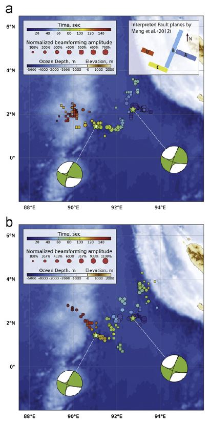
This is their coolest figure, where Duputel et al (2012), in figure 9, plot the epicenters with color representing time. They also plot the orientations of the faults that ruptured in this sequence. Note the interesting orientation of the west-northwest striking faults. There are some northeast striking faults, but the mainshocks were probably on the nw striking faults. Here is the Duputel paper.