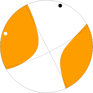
Here is a good sized earthquake swarm in the Andaman Sea. I am a little late posting this, I was otherwise detained.
Here is the USGS webpage for the Mw 6.5 earthquake.
The Andaman Sea is a region of back-arc spreading. The subduction zone is plotted in blue, to the west of these Nicobar Islands. The Nicobar Islands are probably formed by a combination of back thrust and/or strike slip faults. There are spreading ridges (like the Mid-Atlantic Ridge) connected with transform (strike slip) plate boundary faults. The green lines in the map below are the transform faults and the yellow lines are the spreading centers (generally, the USGS kml file is not completely correctly attributed). There are frequent eruptions in the arc volcanoes in this region also.
The largest magnitude earthquake in this swarm is a Mw 6.5 strike slip earthquake. Here is the Mww moment tensor for this earthquake.

Here is the same map with historic earthquakes plotted in grey.
This map that shows the Modified Mercalli Shaking Intensity in the region of the Mw 6.5 earthquake.