Scientists at the National Research Institute for Earth Science and Disaster Prevention have collected and processed seismic data from the High Sensitivity Seismograph Network Japan (Hi-net). They created movies of these data, in map view. Here is the page where they posted these movies. I have translated the text below to make it easier to read, but this is completely their work. I include links to the videos. The first movie shows long period seismic data and the second movie shows short period seismic data.
Here is a link to the USGS web page for this M 7.8 earthquake.
-
Here is a link to my earlier posts about this seismic activity:
- 2015.05.30 First Post: map and cross section
- 2015.05.31 Second Post: triggered and aftershock earthquakes
- 2015.05.31 Third Post: animations of historic seismicity
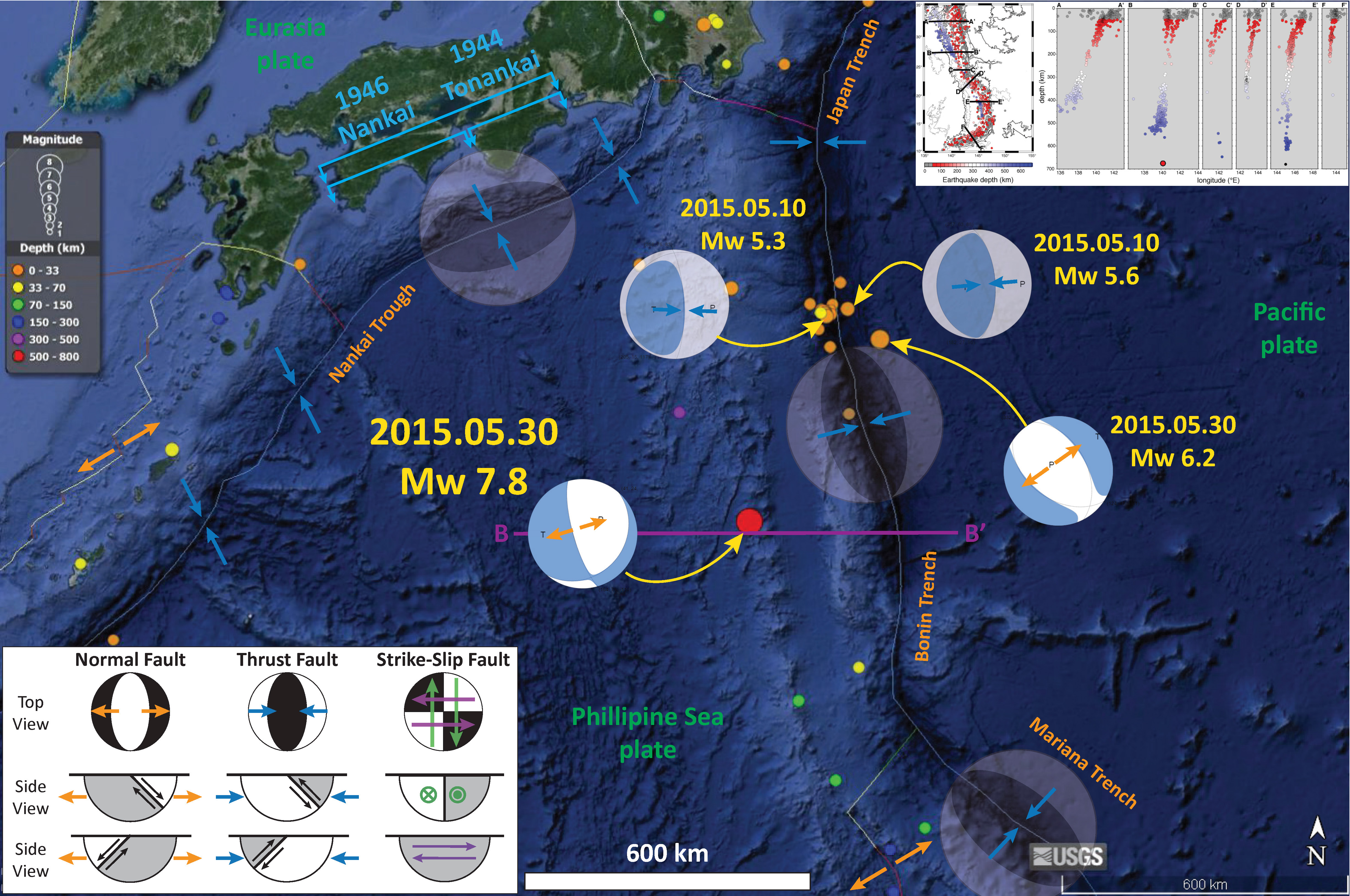
Here is a map that I put together that shows the mainshock, some aftershocks, and some triggered earthquakes.
I place the translated text in block quotes. The original text all comes from here.
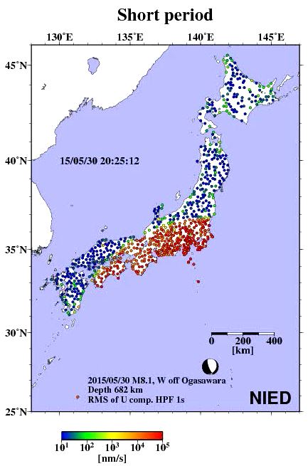
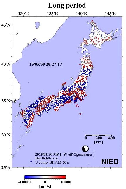
Around 24 pm on May 30, 2015, 20:24, an earthquake of M 8.1 (by the Japan Meteorological Agency) has occurred in the Ogasawara Islands off the west coast. The earthquake, which occurred at a very deep place of about 680km, because scale is large, with observing the strong shaking of magnitude 5 [V] in Tokyo and Ogasawara Village and Kanagawa Prefecture Ninomiya Town, seismic intensity of one or more sway in all prefectures me was observed. In addition, long-period ground motion “around the Kanto region was also observed. Whether by this earthquake Japan archipelago is how the shaking, it was visualized using the observation data of NIED of high sensitivity seismograph network (Hi-net). Try compared the differences transmitted the way of waves of long period (wobbling and then shook) and short period waves (shaking was rattled).
Here is the link of the mp4 file (7 MB).
The Hi-net using seismic appropriate to be observed oscillation of period shorter than one second, but by correcting the characteristics of the seismometer and data acquisition system, of the wave that vibrates with a period several tens of seconds general features it is possible to also be considered . Here, by applying a band-pass (band-pass) filter to the waveform after the characteristic correction, we visualized how the transmitted seismic waves 25 to 50 seconds range. From around 20:25, you can confirm that wave that has spread from the epicenter to the longitudinal Japan to north-northwest. Initially, it is striped red and blue will continue to spread in concentric circles around the epicenter, from around 20:27, the shift has begun to occur in a stripe pattern at the center of the Japanese archipelago. From around 20:28, reflected by the underground, also joined the wave, which is thought to have through the refraction, etc., wave field shows the complex aspects.

Here is the link of the mp4 file (7 MB).
Through the Izu Islands from around 20:25 Kanto, amplitude is increased from the Tokai region coast, you can see that P wave (initial) has arrived. This wave, over a period of about 1 minute half, will continue to longitudinal the Japanese archipelago to Hokkaido northern tip. Over time and towards the West is seen how the amplitude ahead to decay than the East , but this is considered to reflect the region of the attenuation structure of the underground ( * )
-
References:
- Carcole and Sato, 2010. Spatial distribution of scattering loss and intrinsic absorption of short-period S waves in the lithosphere of Japan on the basis of the Multiple Lapse Time Window Analysis of Hi-net data, Geophys. J. Int., v. 180, p. 268-290/li>
1 thought on “Movies: Seismic Record of a Deep Izu-Bonin Earthquake”