We are still having a series of earthquakes in southeastern Idaho. This earthquake appears related to the Bear Valley fault (BVF) system, which is a normal fault system related to extension in the Basin and Range geomorphic province. Here is the USGS web page for this M 5.3 earthquake.
This part of Idaho has a geologic basement that was folded and faulted during the Sevier Orogeny, a period of compressional tectonics between approximately 140 million years (Ma) ago and 50 Ma. Basin and Range extension occurred at a much later time, in the Late Cenozoic (e.g. in northwestern Nevada, it has been demonstrated that the extension is post 15-17 Ma (Colgan et al., 2004, 2006).
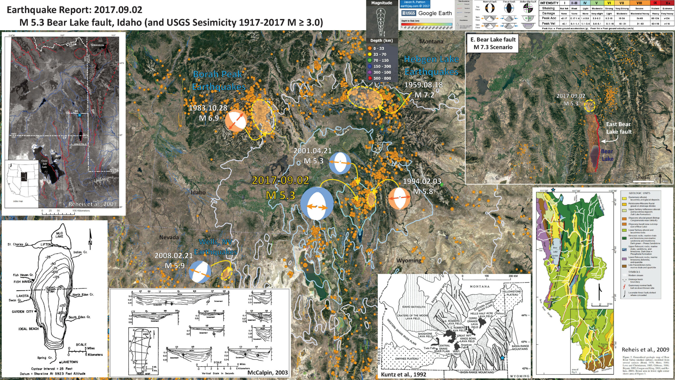
Below is my interpretive poster for this earthquake.
I plot the seismicity from the past month, with color representing depth and diameter representing magnitude (see legend). I also include USGS epicenters from 1917-2017 for magnitudes M ≥ 3.0.
I also include the USGS moment tensor for today’s earthquake. While it is possible that either nodal plane is correct, read below to see how I interpret today’s earthquake given the publications I include in this report (see discussion about inset figures).
Based upon the existing fault geometry, and the seismicity, the BVF may extend further to the north. I include a large scale map below showing this.
I include some moment tensors from some other significant earthquakes in the region. The Hebgen Lake earthquakes happened in 1959. There is a great earthquake museum at Earthquake Lake, which has some good interpretive displays (and a great view of the lake and some ghost forests). The M 6.9 Borah Peak earthquakes happened in 1983. There was a swarm of earthquakes in the Wells, NV area in 2008. I also have placed a moment tensor and a focal mechanism from some of the normal faulting earthquakes nearby (1994 and 2001).
- I placed a moment tensor / focal mechanism legend on the poster. There is more material from the USGS web sites about moment tensors and focal mechanisms (the beach ball symbols). Both moment tensors and focal mechanisms are solutions to seismologic data that reveal two possible interpretations for fault orientation and sense of motion. One must use other information, like the regional tectonics, to interpret which of the two possibilities is more likely. Based upon the series of earthquakes and the mapped faults, I interpret this M 5.1 earthquake as an east dipping normal fault (a northern unmapped extension of the west Bear Valley fault). The depths are currently not of high enough certainty to really tell if this is incorrect (but it may be).
- I also include the shaking intensity contours on the map. These use the Modified Mercalli Intensity Scale (MMI; see the legend on the map). This is based upon a computer model estimate of ground motions, different from the “Did You Feel It?” estimate of ground motions that is actually based on real observations. The MMI is a qualitative measure of shaking intensity. More on the MMI scale can be found here and here. This is based upon a computer model estimate of ground motions, different from the “Did You Feel It?” estimate of ground motions that is actually based on real observations.
- In the upper left corner is a map from Reheis et al., 2009 that shows the major active faults in the region, along with state lines, and an inset locator map. I placed a blue star in the general location of today’s earthquake (similarly in other figures). Below the blue star is Bear Lake, which can be found in other maps and figures as well. Bear Lake is located in a basin being formed by the downdropping of the crust due to slip along normal faults on the eastern and western boundaries of this basin. Based upon today’s earthquakes, it appears that the western BVF extends beneath the eastern BVF (at least in this region, since the earthquakes are beneath the mountain formed to the east of an unmapped segment of the eastern BVF).
- In the lower right corner is another map from Reheis et al., 2009, which shows the regional bedrock and faulting, along with Bear Lake. Note that the M 5.3 earthquake is to the north of this map.
- To the left of this geologic map is a general tectonic mpa for Idaho (Kuntz et al., 1992). This shows the geomorphic provinces that include the Snake River Plain to the northwest of these basin and range faults.
- In the lower left corner is a map showing the bathymetry of Bear Lake (McCalpin, 2003 and references therein). To the right are some line drawings of seismic reflection profiles across the lake. There have been some more modern studies since then, which show similar findings (and additional faulting).
- In the upper right corner I include a larger scale map that shows the distribution of earthquakes (as I type this report, they are still happening), outlined in dashed yellow. I include a delineation of a USGS earthquake scenario for the east Bear Valley fault, which is estimated to be a M 7.3 earthquake. Note how the earthquakes today are to the north of this scenario fault. The USGS page for this M 7.3 Scenario Earthquake is here.
I include some inset figures in the poster.

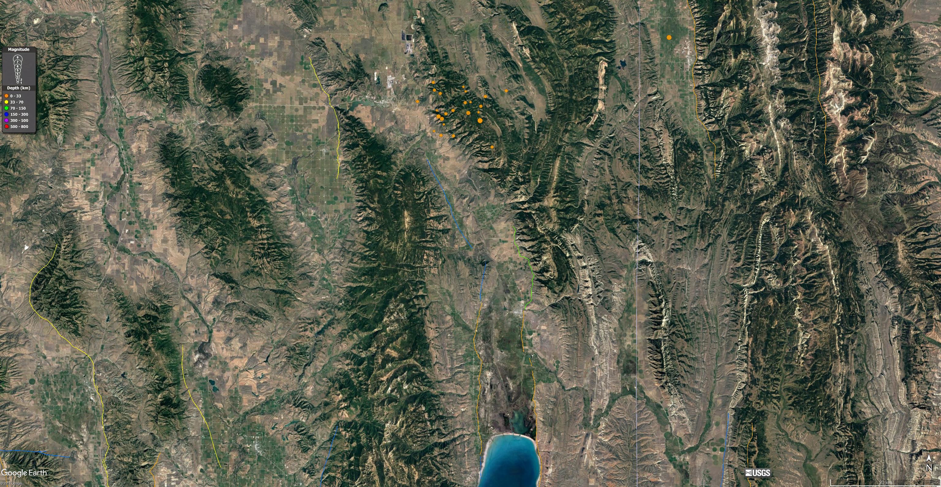
- Here is a large scale map showing today’s earthquakes along with the USGS Active Fault and Fold Database. Note the northern terminus of the East BVF (green line south of the earthquakes and north of Bear Valley Lake). Note the northern terminus of the Eastern BVF (blue line to the west of the green line). Today’s earthquakes are convincing evidence that the West BVF may extend further north than is mapped (and that it may dip beneath the East BVF). It could also be more complicated and not associated with the BVF at all.
- Here is the medium scale tectonic map from Reheis et al. (2009).

Location index map (inset) and regional setting, including drainages (blue) and principal Quaternary faults (red; modified from U.S. Geological Survey, 2004). Red hachured lines are boundaries of Quaternary calderas. Red dashed line is axis of high elevations within tectonic “parabola” of Pierce and Morgan (1992). CV—Cache Valley; GV—Gem Valley; GVF—Grand Valley fault; SS—Soda Springs; SVF—Star Valley fault. Box shows area of Figure 4.
- Here is the larger scale map from Reheis et al. (2009).

Generalized geologic map of Bear River Valley (dashed outline), modified from several sources (Bond, 1978; Hintz, 1980; Love and Christiansen, 1985; Gibbons, 1986; Bryant, 1992; Coogan and King, 2001; and Reheis, 2005).
- Here is the seismic reflection data summarized by McCalpin (2003).
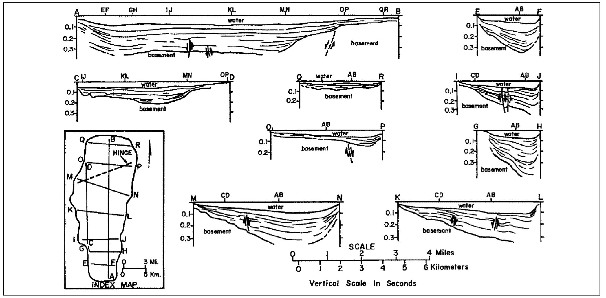
Seismic-reflection profiles from Bear Lake. From Skeen (1976).
- Here is a more modern seismic reflection data set (boomer seismic). This profile shows that the eastern BVF has a higher slip rate (or is more recently more active). These authors found evidence for additional mid-basin faults as well.
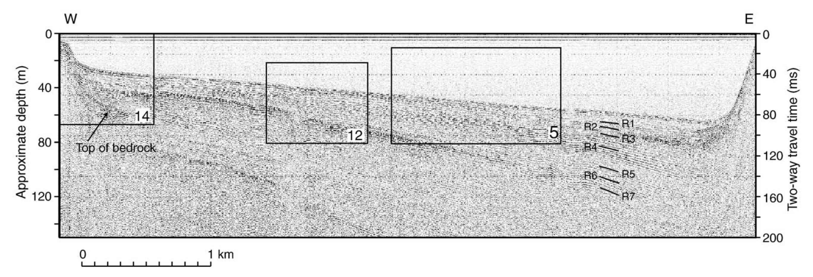
Seismic profile (boomer system) along the entire length of line 28. Location shown in Fig. 1. Boxes labeled in their lower right corners indicate the location of data shown in correspondingly numbered figures. Top of bedrock is shown on the western margin of the profile and reflectors R1–R7 are shown in the deep part of the basin.
- Given my background, I enjoyed viewing this figure from Coleman, 2006. This figure shows how they correlated teh seismic data to the stratigraphy observed in a sediment core collected by C. Heil.

Correlation among the lithology of BL00-1E, magnetic susceptibility (C. Heil, written commun., 2001) and the acoustic-reflection data (boomer system) at the site.
- Here is a map that shows the details of the secondary (mid basin) faults that this author observed (Colemen, 2006). Faults like this accommodate slip on earthquakes that is not accounted for when only looking at the primary faults, the range forming faults at the edge of the basin. These faults can be easily imaged when the basin is filled with water. So, where basins are not filled with water, secondary faults like these may not be well documented (which affects our ability to evaluate seismic hazards).

Map showing the distribution of secondary faults observed on acoustic-reflection profiles.
- There was an earthquake in 1884 that may be an analogue to today’s earthquake (roughly). The M 6.3 earthquake happened on an east dipping fault, antithetic to the east BVF. Below are two maps from Evans et al., 2003.

Geologic map of the study area; data are from Oriel and Platt (1980), Dover (1995), and Janecke and Evans (1999). Normal faults bound basins that are superimposed on Sevier folds and thrusts. The inset map shows the location of the study area in the Intermontain Seismic Belt.

Digital elevation model of the area north of the Bear Lake, with the surface trace of faults interpreted by Robertson (1978) and J. P. McCalpin. Both the West and East Bear Lake faults have produced surface ruptures in the past 10,000 years due to slip from M ≥ 7 earthquakes (McCalpin, 1993). Scarps up to 8 m high are reported for the West Bear Lake fault (Robertson, 1978; Mccalpin, 2003) indicate that these faults have the potential for ground-rupturing earthquakes.
- Coleman, S.M., 2006. Acoustic stratigraphy of Bear Lake, Utah–Idaho—Late Quaternary sedimentation patterns in a simple half-graben in Sedimentary Geology, v. 185, p/ 113-125
- Colgan, J.P., Dumitru, T.A., and Miller, E.L., 2004. Diachroneity of Basin and Range extension and Yellowstone hotspot volcanism in northwestern Nevada in Geology, v. 32, no. 2., p. 121-124 DOI 10.1130/G20037.1
- Colgan, J.P., Dumitru, T.A., McWilliams, M., and Miller, E., 2006. Timing of Cenozoic volcanism and Basin and Range extension in northwestern Nevada: New constraints from the northern Pine Forest Range in GSA Bulletin, v. 118, no. 1/2, p. 126-139, doi: 10.1130/B25681.1
- Kuntz, M.A., Covington, H. R., and Schorr, L. J., 1992, An overview of basaltic volcanism of the eastern Snake River Plain, Idaho, in Link, P. K., Kuntz, M. A., and Platt, L. P., eds., Regional geology of eastern Idaho and western Wyoming: Geological Society of America Memoir 179, p. 227-267.
- McCalpin, J.P., 2003. Neotectonics of Bear Lake Valley, Utah and Idaho; A Preliminary Assessment in Miscellaneous Publication 03-4, Utah Geological Survey, ISBN 1-55791-694-2, 50 pp.
- Reheis, M.C., Laabs, B.J.C., and Kaufman, D.S., 2009, Geology and geomorphology of Bear Lake Valley and upper Bear River, Utah and Idaho, in Rosenbaum, J.G., and Kaufman D.S., eds., Paleoenvironments of Bear Lake, Utah and Idaho, and its catchment: Geological Society of America Special Paper 450, p. 15–48, doi: 10.1130/2009.2450(02)
Hi, I live in Bear Lake Idaho And I was wondering do you think that the earthquakes in Soda Springs will trigger a big earthquake in Bear lake I know earthquakes are not easy in knowing what they will do but if you were guessing and looking at other earthquakes in the past what would you think ? Thanks , Leanne
Hi Jay
any thoughts on the latest seismograph of 09-20-17
HVU SHZ UU 01
time UTC 20:23 ……..
thanks
Pete Santina
pete@smiwater.com