Here is the first update on the 2016.11.13 (UTC) Mw 7.8 Kaikoura Earthquake and associated fault ruptures, ground shaking, and other geologic effects. I will be preparing several more posts on this subject.
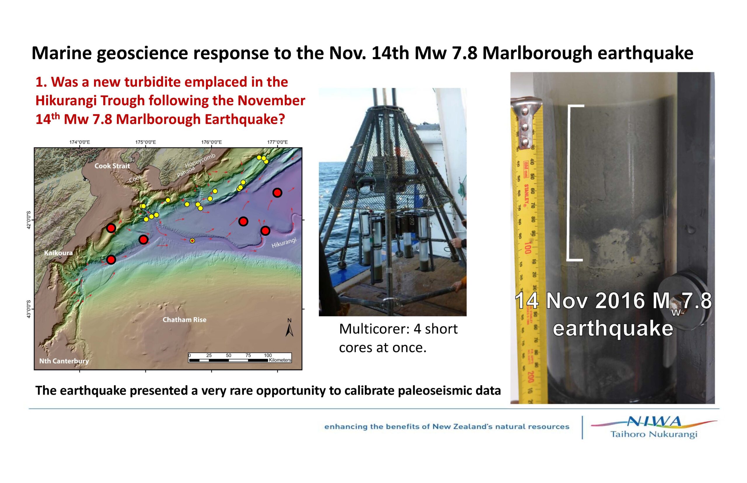
I was invited to participate on a research cruise offshore of new Zealand. Our goal was to collect sediment cores in the deep sea so that we might test the hypothesis that strong ground shaking from earthquakes along the Hikurangi subduction zone generate submarine landslides that can be used to establish an earthquake chronology. This is a new method being used globally. I have applied this method in the northeastern Indian Ocean (offshore of Sumatra: the Andaman-Sumatra subduction zone), the northeastern Pacific (offshore of the Pacific northwest coasts of Washington, Oregon, and California: the Cascadia subduction zone and northern San Andreas fault), and in the western equatorial Atlantic Ocean (offshore of Guadeloupe: the subduction zone along the Lesser Antilles).
The chief scientists for this southwestern Pacific turbidite paleoseismology investigation are Drs. Philip Barnes (NIWA) and Jamie Howarth (GNS).
While we were at sea aboard the R/V Tangaroa, this M 7.8 and associated complicated earthquakes occurred. We initiated planning to modify our goals to include data collection in response to this earthquake series. This included (1) additional sediment coring and (2) seismic reflection and multibeam bathymetric mapping. The coring is important because this earthquake is a small earthquake for turbidite paleoseismology, so the results will be an important contribution to the global studies of trigger magnitude-distance relations. The seismic reflection data are important to determine the extent of surface rupture of the faults offshore. The multibeam mapping also helps extend our observations of surface rupture offshore. These observations will help constrain fault slip models. Some of the results from our cruise are presented below. We prepared this presentation for a press conference immediately following our cruise.
We are currently preparing samples to submit to a lab in New Zealand to test for the presence of short lived radionuclides (7Be and 234Th). We are also conducting biostratigraphic tests on the most recent sedimentary deposit. These tests are an important tool to justify our interpretations that we cored the M 7.8 turbidite using lithostratigraphic constraints.
Related Posts
- My initial Earthquake Report is posted here. I discuss and present observations made following the earthquake.
- My report for prior to the cruise here. I present some background information about New Zealand tectonics. I have learned much more and will post more about this in future reports.
- I presented some updates on our cruise via my blog here. I list some of these posts below (dates are local time).
- 2016.11.09 Getting ready for the cruise!
- 2016.11.10 Planned First Core Site
- 2016.11.13 A few days in
- 2016.11.15 Long Day and Sunset
- 2016.11.15 Caught Up and Planning Ahead
- 2016.11.18 Wrapping up Cruise and Earthquake Response
- 2016.11.18 Earthquake Response Cores/li>
- 2016.11.21 Last Night on the R/V Tangaroa/li>
Information Sources
-
There is an abundance of information and observations coming in from the field. Here is a short list of some sources of photos, maps, etc. Some are official sources and others are social media sources (which generally are also from official sources since it is mostly professionals who are collecting observations right now).
- Geonet is a collaboration between the Earthquake Commission and GNS Science. Here is the main Geonet page and here is an M 7.8 page set up for the sole purpose of announcing observations and preliminary model results.
- National Institute of Water and Atmospheric Research (NIWA) supplied the vessel for the recent turbidite paleoseismology cruise that I participated on. Here is their page on our cruise and our earthquake response activities.
- Here is the GNS page for this M 7.8 earthquake. Institute of Geological and Nuclear Sciences Limited (GNS Science) is comparable to the USGS in the United States.
- Here is the Earthquake Commission page for this M 7.8 earthquake.
- Philip Barnes
- Mark Hemphill-Haley
- Chris Madugo
- Jamie Howarth
- Geoffroy Lamarche
- Alan Orpin
- Jason R. Patton
- Here is Geonet’s twitter page.
- Here is NIWA’s twitter page.
- Here is the GNS Science twitter page.
- Here is the GNS Science Geodesy twitter page.
- Here is the Centre for Observation and Modelling of Earthquakes, Volcanoes, and Tectonics (COMET)’s twitter page.
- Dr. Mark Hemphill-Haley’s facebook page. Dr. Hemphill-Haley (the Humboldt State University, Department of Geology Chair) leads the surface rupture observation team for GEER.
- Dr. Kate Clark’s (GNS Science) twitter page.
- Danielle Madugo’s twitter page. Her husband, Dr. Chris Madugo, is on the GEER surface rupture observation team.
- Dr. Jason R. Patton’s (Humboldt State University, Department of Geology) twitter page. (my page, heheh)
- Dr. Yu Morichita’s (GSI in Japan) twitter page. Morichita San works on Interferometric Synthetic Aperture Radar (InSAR) to measure surface deformation from earthquakes.
- Dr. Eric Fielding’s (NASA JPL) twitter page. Dr. Fielding also works with InSAR data.
- 2016.11.22 RNZ Eadio
- Compilation: Radio New Zealand
Official Sources
Researchgate Sources
Social Media
Organizations
Persons
News Stories
There are more and I will add them as I find time…
Press Conference
- We arrived at port about 8 AM and the press conference was at 2 PM. No rest for the wicked. The fearless leaders of our R/V Tangaroa research cruise were Drs. Philip Barnes from NIWA and Jamie Howarth from GNS Science.
- Here is the digital press release as displayed blow: (pdf)
Here are the slides that we put together for our press conference.


Some Cruise Videos
Observations Made Prior to Earthquake
In 2000, several Humboldt State University, Department of Geology students joined a faculty member (Dr. Raymond “Bud” Burke, a soils geomorphologist) in a trip to New Zealand. They traveled to work with Russ Van Dissen from GNS, an HSU graduate (he also went to Oregon State University and worked with Dr. Bob Yeats). Their efforts were to investigate faulting along the Kekerungu fault. They established that the Kekrungu fault is the main plate boundary fault in this region. Here is the accepted abstract currently being presented at a geological conference in New Zealand. These scientists had established that this fault system was capable of doing what it just did. I remember helping to prepare some field maps for this trip, but the GIS data available at the time was scarce and my maps were of little utility to the team.
-
The students included
- Steve N. Bacon
- Ronna Bowers
- Harland L. Goldstein
- Joanna R. Redwine
- Diane G. Sutherland
- Stephen F. Tilinghast
Here is the abstract:

- Here is an interview from Russ Van Dissen as posted on the radio New Zealand website here. More from RNZ on this subject can be found here and a compilation of stories here.
- Here is a link to the embedded video below (70 MB mp4)