We just had an earthquake near the Santa Cruz Islands in the western Pacific Ocean. Here is the USGS web page for this earthquake. Here is a map that I quickly put together with the moment tensor from the M…
Earthquake in the Solomons!
While I was away from the office, we had a M 6.7 earthquake near the Solomon Islands. Here is a link to the USGS website for the M = 6.7 and M = 6.0 earthquakes. While the epicenter plots near…
Blanco Fracture Zone: 2000 – 2015 Seismicity Animation
I put together an animation that includes the seismicity from 1/1/2000 until 6/1/2015 for the region near the Blanco fracture zone, with earthquake magnitudes greater than or equal to M = 5.0. The map here shows all these epicenters, with…
Earthquake in Izu-Bonin!
Early this morning (luckily I was not awake at the time) we had a really deep (~677km) M = 7.8 extensional earthquake along the Bonin Trench in the western Pacific. Here is the USGS page for this earthquake. Here is…
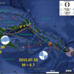
Santa Cruz Islands Earthquake!
We just had an earthquake in the Santa Cruz Islands region. Earliest reports has the magnitude at M = 6.9, with a depth of 19.9 km. This earthquake appears to align with a transform boundary that connects the New Hebrides…
New Britain Strikes Again!
In the past week, there has been a series of earthquakes in the New Britain trench. The largest quakes are M = 6.7 & 6.8. Now we might call those foreshocks to today’s M = 7.5 earthquake de Cinco de…
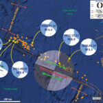
Earthquake Pair in New Britain
Good Morning New Britain. Today we had a second M = 6.8 earthquake in as many days. Here are the USGS web pages for the 2015.04.30 and 2015.05.01 earthquakes. Here is my quick post from yesterday’s earthquake. Here is a…
Earthquake in New Britain
Well, we just had a Mw 6.7 earthquake along the coast of New Britain. This region has been active lately… Here is the USGS web page for this earthquake. Here is a map showing the epicenter with Modified Mercalli Intensity…
Earthquake near Taiwan
Well, we just had a swarm of earthquakes with magnitudes near Taiwan. The USGS web pages for these earthquakes are here: M = 6.0, 6.1, and 6.4. This is a complicated tectonic region and there are many different and differing…
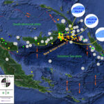
New Britain and Bougainville: tectonic domains?
I was taking a looksie at the different moment tensors for the years of 2000, 2010, 2014, and March 2015. I noticed that the transform plate boundary on the eastern side of the South Bismarck plate may separate segments of…