There was a M 3.6 earthquake near Concord, CA. This earthquake was felt widely across the S.F. Bay area. The two earthquakes plotted in the map below are both just southeast of the 2014 August Napa earthquake. The Napa earthquake,…
Mendocino fault earthquake
We had a small magnitude earthquake “today” along the Mendocino fault system approximately 150 km west of Cape Mendocino. Here is the USGS web page for the Mw 4.8 earthquake. Based upon the tectonic setting, the hypocentral depth, and the…
Lake Almanor: Indian Valley fault activity
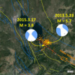
There was an earthquake swarm in this region in 2013. The largest magnitude earthquake had a magnitude of M = 5.7. Here is the USGS page for that earthquake. “Today” we got a M = 3.8 earthquake in this same…
Stress Changes from Strike Slip Faults
One may ask what are the relations between the Mendocino fault (MF) and the Cascadia subduction zone (CSZ). Earthquakes on both fault systems are responding to the same plate motions. As the Gorda plate moves to the east, relative to…
Mendocino fault earthquake 1/28/15 1:08 PM local time
We just had a good sized shaker, probably on the Mendocino fault system. Today’s earthquake occurred on 1/28/2015 at 1:08 local time. The mainshock, an earthquake of magnitude Mw = 5.7, has an epicenter approximately 20 km due west of…
Lassen Earthquake Swarm
There is currently an ongoing earthquake swarm in the region immediately south of Mt. Lassen. The largest magnitude is a M 3.9 (USGS). The California Volcano Observatory (CalVO) is monitoring these earthquakes. The earthquakes do not appear to be related…
Napa Earthquake Update
There have been a swarm of geologists running around Napa taking photos and documenting evidence from the earthquake swarm on Sunday. Here is my first post about this earthquake swarm, with the M 6.0 earthquake being the largest magnitude earthquake.…
Napa Earthquake!
Social media was abuzz today about the M 6.0 earthquake in Napa. Here is the USGS webpage for the M 6.1 earthquake. This earthquake, and the aftershocks, have epicenters that lie between the Rogers Creek and Green Valley fault systems.…
SCEC Animation of earthquakes in Southern CA 1983-2003
Here is an animation from the Southern California Earthquake Center that shows earthquake hypocenters in relation the SCEC fault model. By clicking on the map below, you will download a 24 mb avi file. Some browsers may open the video.
SCSN animation of the seismic waves from the Puente Hills Thrust fault
The Southern California Seismic Network published this animation. Robert Graves, with the URS corporation, created the simulation. The San Diego Super Computer Center also helped. They are all given proper credit in the animation. The animation shows the simulated seismic…
