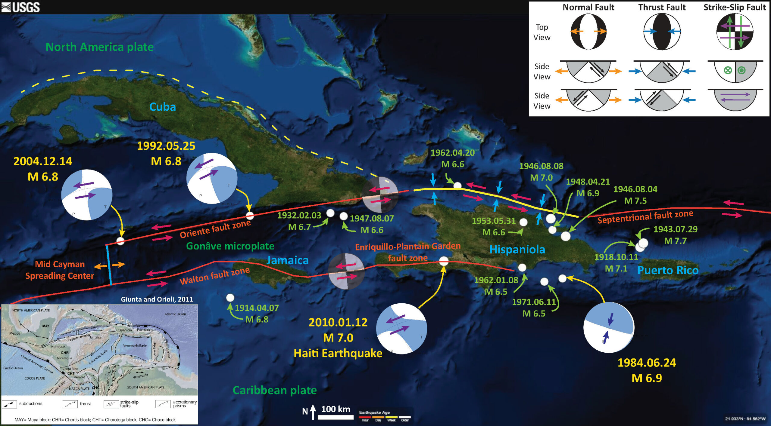
Following yesterdays earthquakes in Cuba, I put together an earthquake summary poster for this region for the period from 1900 through Jan 17, 2016. Here is the USGS query that I used to get the data.
Here is my Earthquake Report for the three earthquakes south of Cuba from yesterday. These earthquakes appear to have occurred along a left-lateral strike-slip fault system. I include some embedded animations about the different types of earthquake faults below.
-
Here are the USGS web pages for the earthquakes plotted on the map below.
- 1918.10.11 M 7.1 Puerto Rico
- 1932.02.03 M 6.7 Cuba
- 1941.04.07 M 6.8 Jamaica
- 1943.07.29 M 7.7 Puerto Rico
- 1946.08.04 M 7.5 Dominican Republic
- 1946.08.08 M 7.0 Dominican Republic
- 1947.08.07 M 6.6 Cuba
- 1948.04.21 M 6.9 Dominican Republic
- 1953.05.31 M 6.6 Dominican Republic
- 1962.01.08 M 6.5 Dominican Republic
- 1962.04.20 M 6.6 Haiti
- 1971.06.11 M 6.5 Dominican Republic
- 1984.06.24 M 6.9 Dominican Republic
- 1992.05.25 M 6.8 Cuba
- 2004.12.14 M 6.8 Cayman Islands
- 2010.01.12 M 7.0 Haiti
Here is the map. I show the USGS epicenters and have plotted the USGS moment tensors for the earthquakes that have them calculated. The earlier earthquakes do not have these data. Like the map from yesterday, I include an inset from Guinta and Orioli (2011) that shows more details about the tectonics from this region. More can be found in their paper here.
There is a legend that shows how moment tensors can be interpreted. Moment tensors are graphical solutions of seismic data that show two possible fault plane solutions. One must use local tectonics, along with other data, to be able to interpret which of the two possible solutions is correct. The legend shows how these two solutions are oriented for each example (Normal/Extensional, Thrust/Compressional, and Strike-Slip/Shear). There is more about moment tensors and focal mechanisms at the USGS.

Here is another map showing the complicated faulting in the region (that is not reflected in my earthquake history map above!). This is from Prindell et al. (2005). I include their caption as a blockquote below. Prindell et al. (2011) present their comprehensive interpretation of the tectonic history of the region.
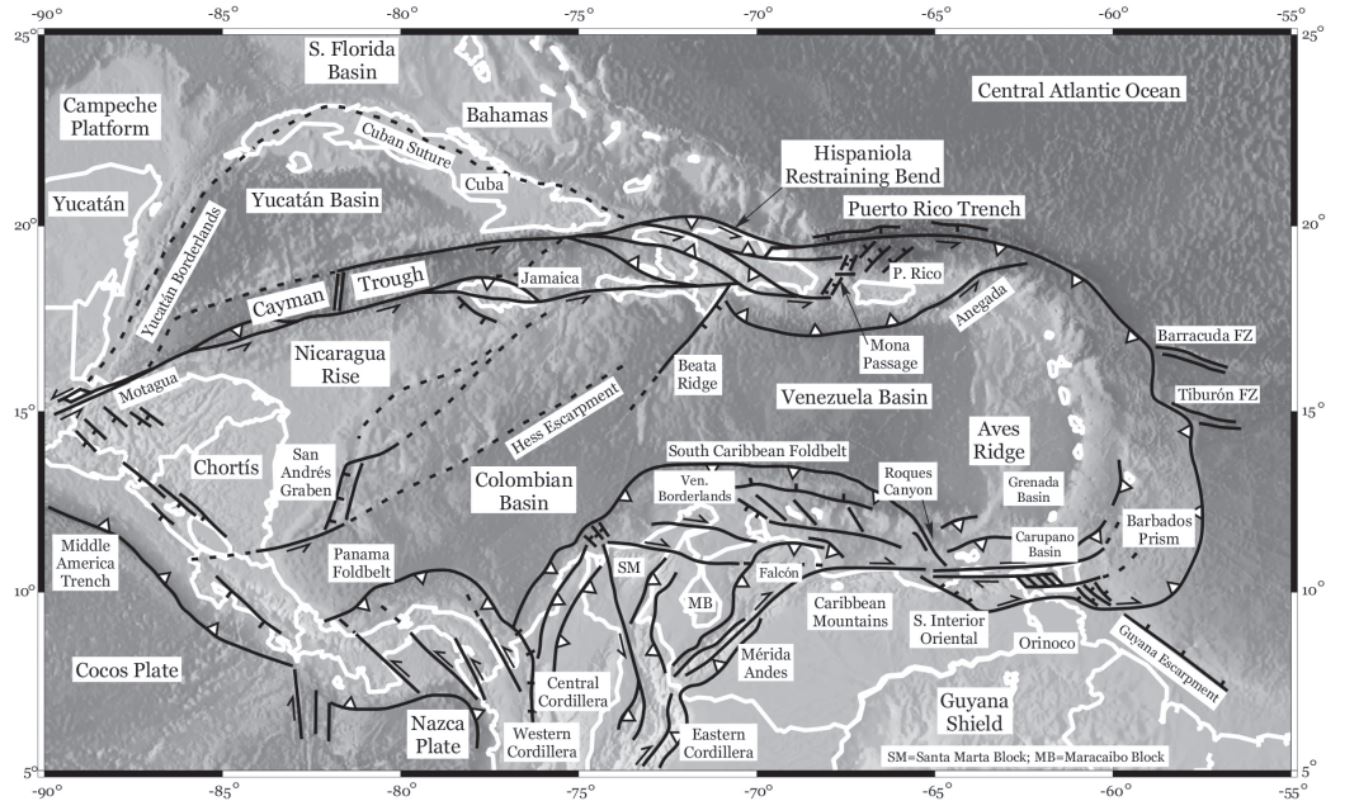
Plate-boundary map and bathymetry of the circum-Caribbean region, showing key tectonic features and geological provinces discussed in the text. Leading and trailing boundaries of the Caribbean plate are subduction zones associated with active volcanic arcs (Lesser Antilles and Panama–Costa Rica arcs, respectively). The southern plate boundary with Colombia, Venezuela, and Trinidad is wide, diffuse, and complex; strain is partitioned between thrust faulting and strike-slip faulting associated with development of pull-apart basins. Similarly, prior to the Eocene collision of Cuba with the Bahamas Bank, the northern plate boundary was also wide and complexly partitioned. Post-collision, the plate boundary was reorganized, with motion now concentrated on the relatively simple Cayman Trough in the west, whereas complexly partitioned thrust and strike-slip faulting continues in the Puerto Rico segment.
For more on the graphical representation of moment tensors and focal mechnisms, check this IRIS video out:
There are three types of earthquakes, strike-slip, compressional (reverse or thrust, depending upon the dip of the fault), and extensional (normal). Here is are some animations of these three types of earthquake faults. Many of the earthquakes people are familiar with in the Mendocino triple junction region are either compressional or strike slip. The following three animations are from IRIS.
Strike Slip:
Compressional:
Extensional:
This figure shows what a transform plate boundary fault is. Looking down from outer space, the crust on either side of the fault moves side-by-side. When one is standing on the ground, on one side of the fault, looking across the fault as it moves… If the crust on the other side of the fault moves to the right, the fault is a “right lateral” strike slip fault. The Mendocino and San Andreas faults are right-lateral (dextral) strike-slip faults.
![]()
Here is an IRIS animation showing a transform plate boundary fault as it relates to spreading ridges.
-
References:
- Guinta, G. and Orioli, S., 2011. The Caribbean Plate Evolution: Trying to Resolve a Very Complicated Tectonic Puzzle in Sharkov, E.B., ed., New Frontiers in Tectonic Research – General Problems, Sedimentary Basins and Island Arcs, DOI: 10.5772/18723
- Pindell, J., Kennan, L., Maresch, W.V., Stanek, K.-P., Draper, G., and Higgs, R., 2005. Plate-kinematics and crustal dynamics of circum-Caribbean arc-continentinteractions: Tectonic controls on basin development in Proto-Caribbean margins, in Avé Lallemant, H.G., and Sisson, V.B. eds., Caribbean–South American
plate interactions, Venezuela: Geological Society of America Special Paper 394,p. 7–52, doi: 10.1130/2005.2394(01).