Shively Fault Paleoseismic Investigation
A paleoseismic investigation of the Shively fault zone, Collaborative Research with the California Geological Survey, Cal Poly Humboldt, and the U.S. Geological Survey.
Abstract
Seismic hazards in coastal northern California are controlled by two overlapping plate boundary systems, the Cascadia subduction zone (CSZ) and the San Andreas fault system (SAF), which meet in the Mendocino triple junction (MTJ) region. This proposed project lies at the crossroads of these two regimes. Crustal faults in the MTJ region pose a risk to the communities of Eureka, Arcata, Fortuna, and dozens of underserved communities. In addition, there is existing infrastructure at risk (highways, utilities, etc.) and the forthcoming wind-energy transmission line infrastructure (a new 500 kV substation and two 500 kV lines, which will feed electricity to the larger California Independent System Operator electric grid) that will also be at risk. Currently, these faults are far less well understood compared to the CSZ and SAF fault systems.
We propose to investigate the Shively fault, one of these crustal faults in the MTJ. For the Shively fault there remains considerable uncertainty about its slip rate, sense of motion, slip per event information, and earthquake recurrence information. For this pilot study, we propose to collect sedimentary stratigraphic and fault trench excavation observations to establish a basic framework for these types of data. This is the first of many future studies that will be required before we have a comprehensive understanding of the seismic hazards for this region.
Cutting across latest Quaternary fluvial terraces along the Eel River near Shively, California, are exposed topographic escarpments. The scarps are south facing and have increasing heights associated with older and higher terrace treads (scarp size scales with age, evidence of growth over time). We hypothesize that these scarps are formed by coseismic slip along a fault that is a part of the Shively fault zone.
We propose to use two primary field methods to approach this problem.
- Sediment coring
- Fault trenching
The objectives of this project are the following:
- Establish prehistoric history of faulting
- Develop slip-per event data
- Establish a late-Quaternary dip-slip rate for this fault
We anticipate the results will provide constraints to characterize the Shively fault for incorporation into the USGS Quaternary Active Fault and Fold database and the USGS National Seismic Hazard Model. These results will also allow us to compare slip rates at different time scales, including a decadal scale geodetically derived slip rate.
If the results support our hypotheses, the implications are that we will improve the estimate of the size, recurrence interval, and effects of past, late Quaternary crustal earthquakes in the MTJ region. This information can be used to test the hypothesis that the Shively fault is a source of seismic hazard.
Significance of the Project
Seismic Hazard in the Mendocino Triple Junction – Is the Shively Fault an Active Fault Source?
The two largest contributors to seismic hazards in California are the Cascadia subduction zone (CSZ) and the San Andreas fault (SAF) systems (Figure 1). These sources overlap in the region of the Mendocino triple junction (MTJ) and may interact in ways we are only beginning to understand as evidenced by the 2016 M7.8 Kaikōura earthquake in New Zealand (Clark et al., 2017; Quigley et al., 2017; Xu et al., 2017; Litchfield et al., 2018), which occurred along a similar subduction/transform boundary, and included co-seismic rupture of more than 20 faults.
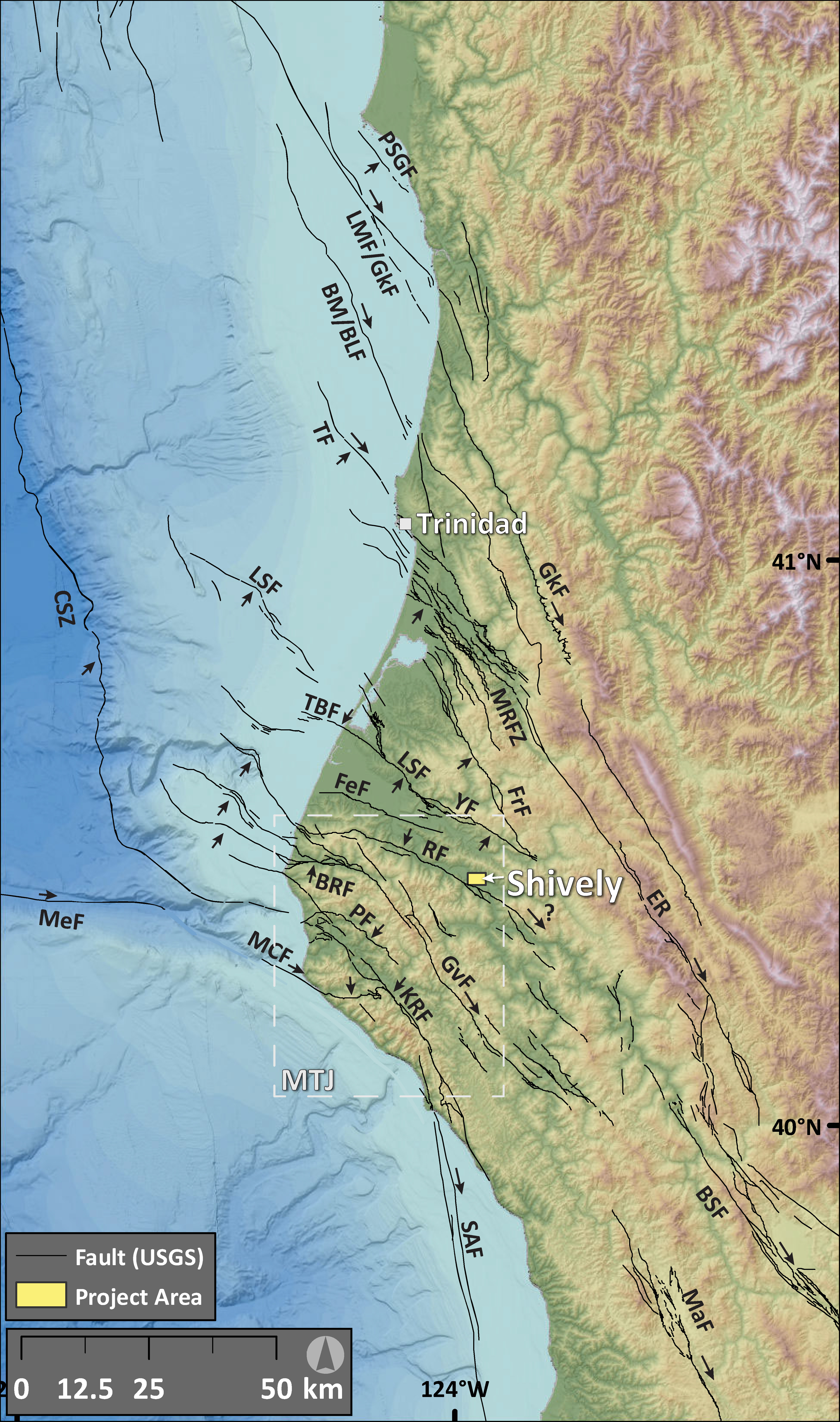
Figure 1. Mendocino triple junction map relative to project area and Shively, California. Fault data from USGS Quaternary Active Fault and Fold Database (2019). Arrows designate direction of fault motion and are placed on the footwall for reverse faults. The Mendocino triple junction (MTJ) region is outlined. Faults: BRF, Bear River; BSF, Bartlett Springs; BM/BLF, Bald Mountain/Big Lagoon; CSZ, Cascadia subduction zone; ER, Eaton Roughs; FeF, Ferndale; FrF, Freshwater; GkF Garlock; GvF, Garberville; KRF, King Range; LM/GF, Lost Man/Garlock; LSF, Little Salmon; MCF, Mendocino Canyon; MaF Maacama; MeF Mendocino; MRFZ, Mad River; PF, Petrolia; PSGF, Point St. George, RF, Russ in red; TBF, Table Bluff; TF, Trinidad; YF, Yager.
The northward migration of the MTJ is evidenced by deformation along the leading western edge of the Sierra Nevada block in the form of rapid uplift of the King Range (Merritts and Bull, 1989; McKenzie and Furlong, 2021), termination of the San Andreas fault system which may step eastward to the Eaton Roughs and Grogan fault zones (Beeson et al., 2017; Kelsey and Carver, 1988) or terminate as uplift along north and northeastern vergent King Range Thrust and Russ faults (McLaughlin et al., 2000, 2012), east-west trending south-southwest vergent faults and folds in the Humboldt Bay region (e.g. Table Bluff, Eel River syncline; Ogle, 1953), and overlap of strike-slip tectonics with Cascadia subduction thrust tectonics (Kelsey & Carver, 1988; Gulick and Meltzer, 2002; Williams et al., 2002; McKenzie and Furlong, 2021) (Figure 2). There exists about 8- to 9-mm/yr north-south contraction between Trinidadand the MTJ (Figure 1), which is most likely accommodated by contraction across these east-west striking structures and unrelated to Cascadia related tectonics (Williams et al., 2002).
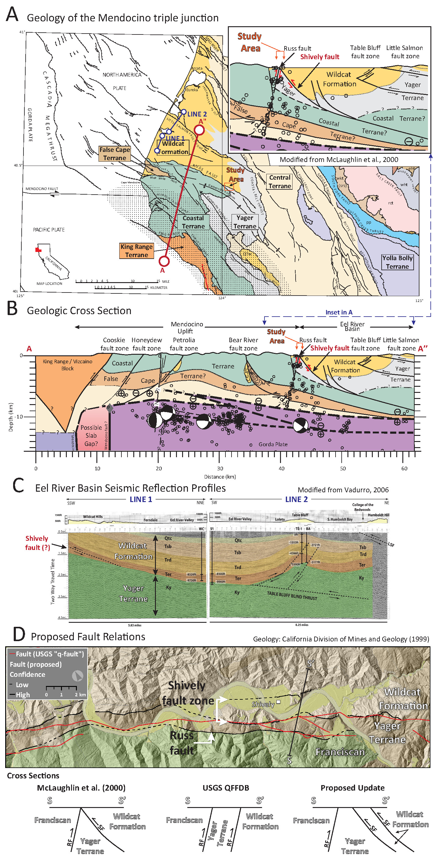
Figure 2. Geology of the Mendocino triple junction. A. Geology map (McLaughlin et al., 2000) showing major basement rocks in the region and cross section locations. B. Cross section A-A’’ shows the structures in the subsurface. Note the Russ and Shively faults. C. Eel River seismic reflection profiles Line 1 & 2 show updated stratigraphic-structural relations of the Eel River Basin (Vadurro et al., 2006) and the Shively fault. E. Updated fault mapping proposed for this proposal. On the map, the USGS QFFDB Russ fault is shown in red and updated RF and SF mapping in black. Schematic cross-sections S-S’ show the MacLaughlin, QFFDB, NSHM, and proposed structural relations between these faults with opposing vergence in the Shively area.
Lidar data acquisitions (Dietrich, 2014; USGS, 2019) have revealed previously unknown recent active faults within the MTJ region. We propose to conduct paleoseismic and slip rate investigations to determine how they contribute to the seismic hazards of the region. We have identified an east-west striking topographic escarpment that shows evidence for vertical displacement of late Quaternary fluvial terrace treads. This scarp is most likely formed by earthquakes along a south vergent fault suggested to exist by McLaughlin et al. (2000) and Vadurro et al. (2006), named the Shively fault (SF) in this proposal (Figure 2). This Shively fault is an apparent active seismic source given its morphology and location.
Significance of Project
Results from this proposed research will improve estimates of size, recurrence interval, and effects of past, late Quaternary crustal earthquakes in the MTJ region. This information may be used to contribute a new source of seismic hazard, capable of magnitude M7 earthquakes, into the California Geological Survey (CGS) active fault database, the USGS Quaternary Fault and Fold Database (QFFDB), the SCEC/CRESCENT Community Fault Models (CFMs), and possibly the National Seismic Hazard Model (NSHM).
Summary of Past Work
The Russ fault was mapped by Ogle (1953) as a north vergent reverse fault dipping at about 85° to the south that serves as a terrane bounding fault, separating the False Cape (FC) and Coastal terranes of the Franciscan Complex and the Yager terrane from the Neogene Wildcat Formation (Figure 2 A). While Ogle maps the RF as a geologic bedrock fault boundary, McLaughlin et al. (2000) mapped the RF to the north of this geologic boundary in places and this mapping has been incorporated into the USGS FFDB and NSHM. None of these three sources (Ogle, McLaughlin, USGS) place the fault in the same location. This has caused confusion with interpreting the south vergent fault scarp in Shively, which daylights along where the RF has been mapped.
In their cross section (Figure 2 B) McLaughlin et al. (2000) shows a south vergent reverse fault that displaces Miocene to Quaternary Wildcat Formation rocks (which comprise the Eel River Basin) over Paleocene to Eocene Yager Terrane rocks. This fault daylights north of the RF as shown in the cross section but not on their map and we hypothesize that this is the south vergent Shively fault. Vadurro et al. (2006) use seismic reflection data to show a south vergent reverse fault along the southern boundary of the Eel River Basin (Figure 2 C) and we posit this is the Shively fault. We updated the fault mapping in the eastern portion of the region where the RF is currently mapped (red lines in Figure 2 D) to be consistent with our existing knowledge of the structural relations mapped by Ogle and McLaughlin. We place the RF at the boundary of the Franciscan Coastal and Yager Terranes. We place the Shively fault strands at the geologic contact between the Yager and Wildcat rocks (and within the Wildcat Formation) and along the base of south facing topographic scarps generally north of the geologic contact (there are two strands of the Shively fault in places). We posit that in some places these south vergent faults have been incorrectly mapped as faults within the Russ fault zone.
NSF and USGS lidar topographic data (Dietrich, 2014; USGS, 2019) and geodetic data (Patton et al., 2023) both form the basis for our discovery of a topographic escarpment that crosses several fluvial terraces southeast of Scotia, California (Figure 3). This south facing scarp crosses multiple terraces near Shively with increasing scarp heights on progressively older terraces (Figure 4). The highest and oldest terrace stratigraphy is founded upon a strath cut into northwest-dipping Wildcat Formation rocks, overlain by gravel to silty sand deposits with a thickness of approximately 15m (Figure 5). A strath terrace is an erosional unconformity formed by fluvial erosion, which has overlying river and hillslope sediments. We mapped geomorphic and geologic units in the Shively area to better understand the stratigraphy, to correlate terraces with numerical age constraints with those in Shively, to assess how faulting controls topography, and to locate potential future field investigations. We have since extended this terrace mapping throughout the entire Eel River watershed (and we have identified additional targets for future USGS EHP research proposals). Our USGS collaborators are funding OSL & cosmogenic age analysis for terrace T-2 which we sampled in June 2023.
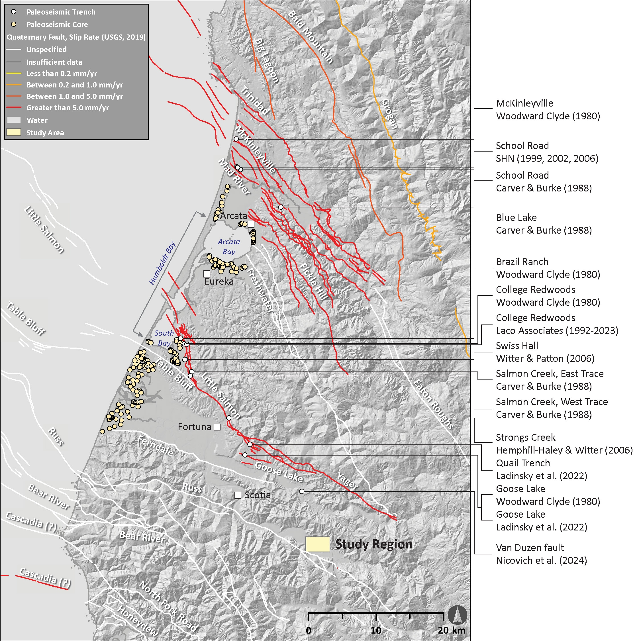
Figure 3. Paleoseismic investigations in the Mendocino triple junction. Trench locations are displayed as white circles. Paleoseismic cores are shown as orange circles. USGS QFFDB faults are displayed relative to their assigned slip rates in mm per year.
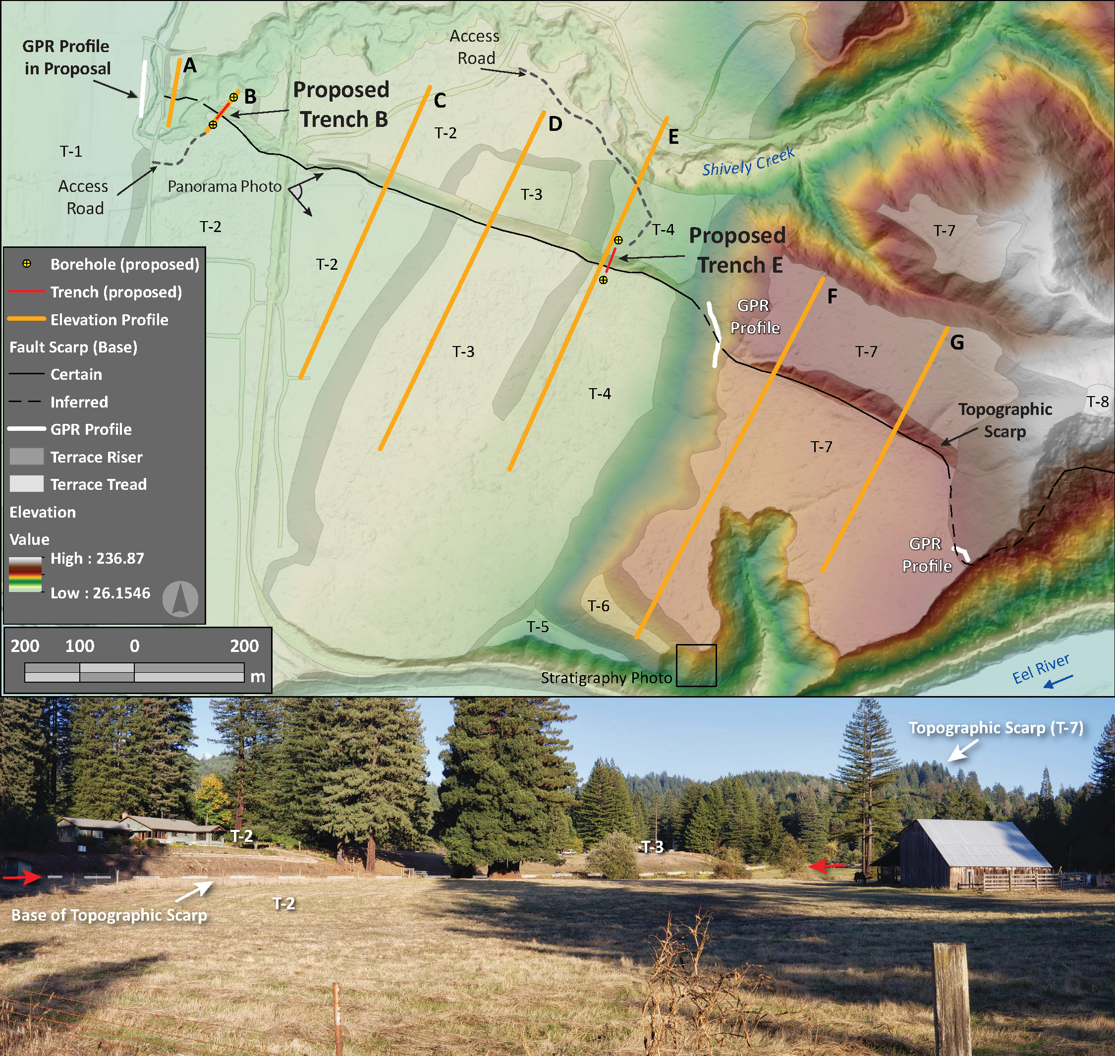
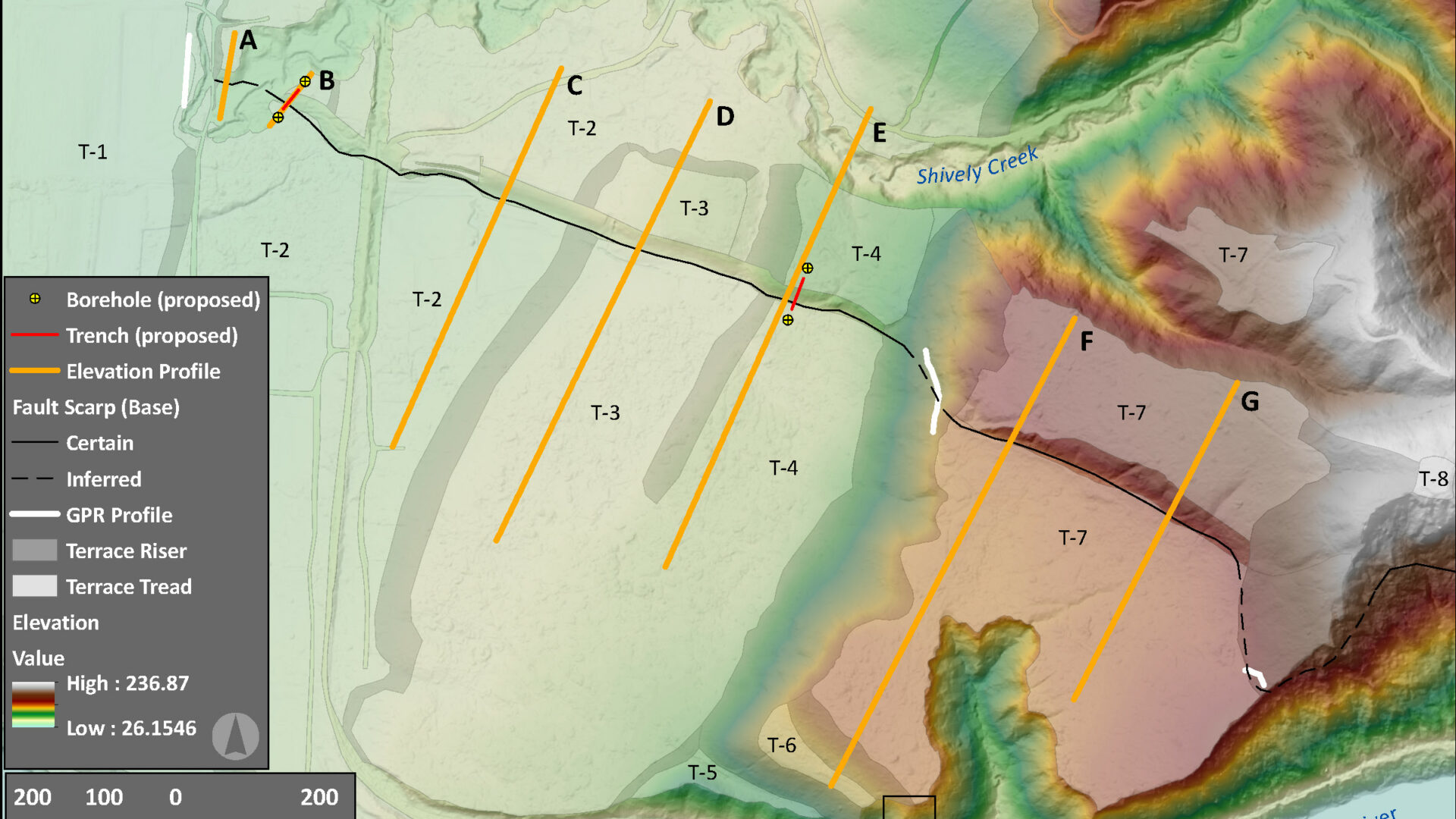
Figure 4. Terraces at Shively, California. USGS lidar topography as a base map with topographic profiles (used in slip rate estimates) in orange, access roads in dashed gray, and proposed trench and borehole sites designated. Terrace treads numbers and GPR profile locations are labeled. Lower: eastward looking panorama photo of topographic scarp.
Table 1.
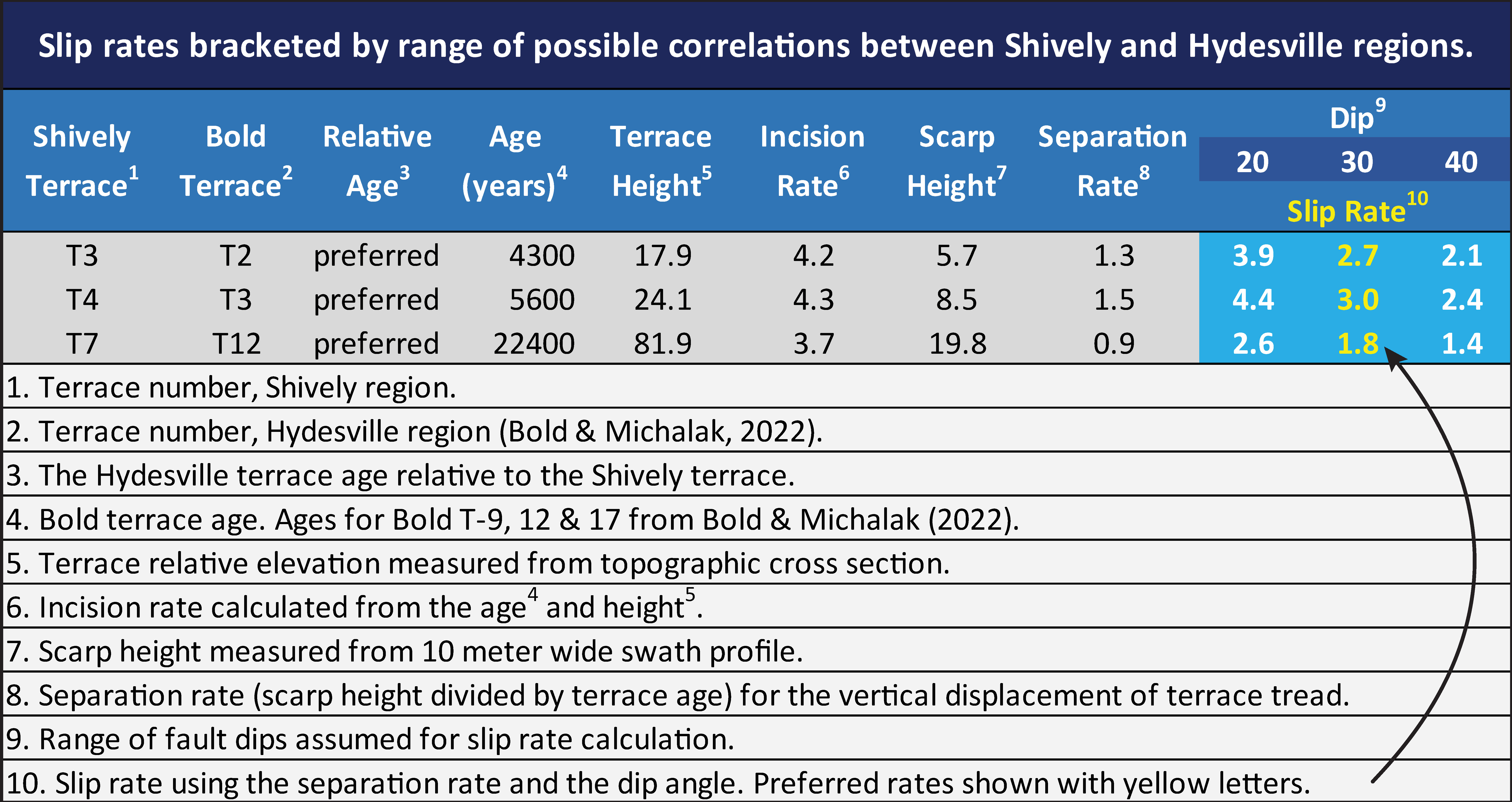
Table 2.
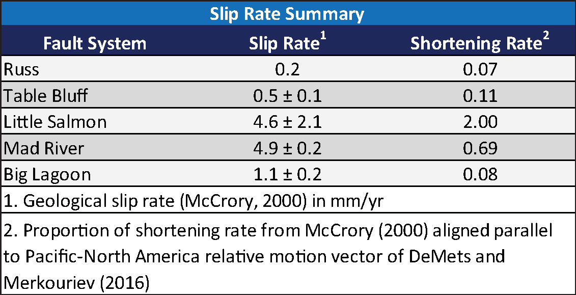
Table 3.
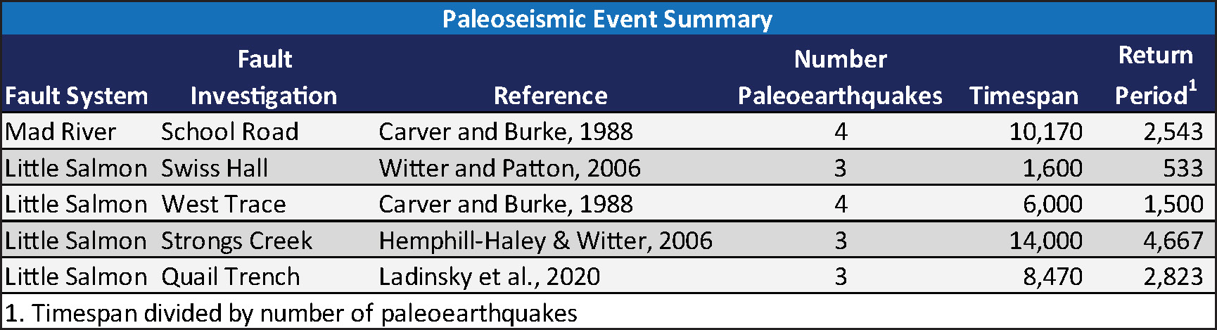
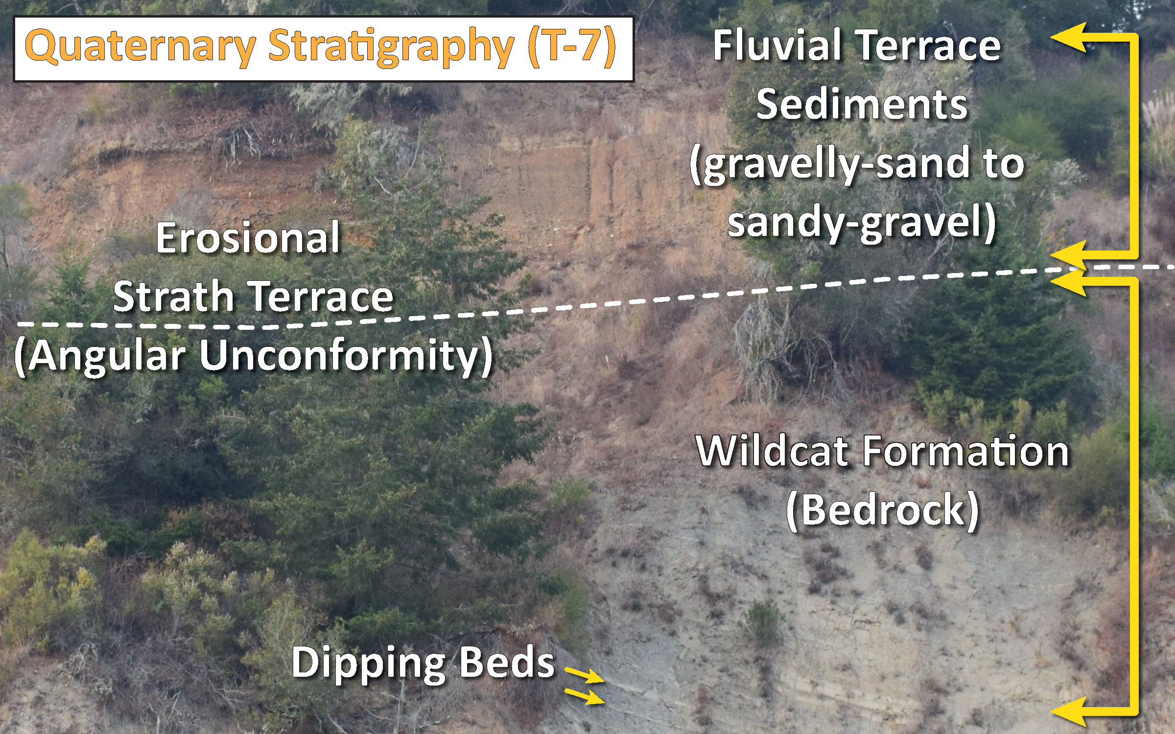
Figure 5. Terrace stratigraphy. Quaternary terrace sediments are shown unconformably overlying NE dipping Wildcat Formation.
The surface trace of the fault we have identified is mapped as 3 km long and, based on fault length magnitude scaling relations, could result in a ca. MW 5.6 earthquake (Wells and Coppersmith, 1994). If the 2m high scarp on the lower terrace represents a single event scarp, the magnitude could be MW 6.7 (Wells and Coppersmith, 1994). If our proposed updated fault mapping is correct, the fault has a potential for a MW 7 to MW 7.2 earthquake (Wells and Coppersmith, 1994). Coseismic ground shaking could potentially cause damage in the cities of Rio Dell and Fortuna, as well as other outlying communities.
In 2019 we conducted multiple Ground Penetrating RADAR (GPR) surveys in collaboration with Dr. Ashley Streig and her graduate student Ryan Levinson from Portland State University. Preliminary data from profiles on T-1, T-7, and along a road that traverses T-4 and T-7 (Figure 4), suggest a fault that dips between 20° and 30° to the north (Figure 6, Patton et al., 2022 A).
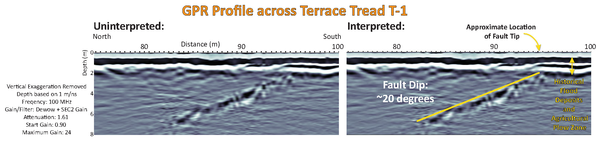 Figure 6. Ground Penetrating radar profile across terrace tread T-1. Lower: interpretation of fault dipping to the north at about 20°. Other GPR profiles support 30° fault dip interpretation.
We use regionally derived incision rates and fluvial terrace correlations (Stallman and Kelsey, 2006; Bold, 2022) as a proxy for terrace age. We then use topographic swath profiles (Figure 4) to measure scarp heights along with the GPR based fault dip approximations to estimate a preferred late Pleistocene slip rate for the apparent fault of 1.8 to 3.0 mm/yr (Table 1, further explained in Patton et al., 2022 A).
Figure 3 shows the limited paleoseismic data for most Quaternary active faults in the region and we present a geologic slip rate summary from McCrory (2000) in Table 2. These paleoseismic investigations are compiled in Hemphill-Haley et al. (2006) and Patton et al. (2022 B). We list the results from these paleoseismic investigations in Table 3 (these return periods do not account for time since the most recent event, MRE, which is poorly dated in most cases). Note that some paleoseismic investigations displayed in Figure 3 lacked direct evidence for paleoearthquakes, or lacked sufficient data to document paleoearthquakes (e.g., no offsets of geologic units or lack of numerical age control). This proposed effort will begin to fill these knowledge gaps and begin to provide records for calibration and comparison.
We consider the north-south contraction across structures in the region as a constraint for the 8- to 9-mm/yr San Andreas-parallel shortening near the study site (Table 2). There remains approximately 5- to 6-mm/yr of contraction currently unaccounted for. Alternatively, Materna et al. (2023) use viscoelastic modeling to estimate this San Andreas-parallel oriented contraction (via slip deficit on crustal faults) to be about 4- to 5-mm/yr, leaving about 1- to 2-mm/yr of unaccounted contraction. The Shively fault likely accounts for some of this contraction.
Hypotheses and Research Questions
Does the Shively fault have a Holocene record of earthquakes?
Hypothesis: There is stratigraphic-structural evidence of discrete offsets of geologic units that can provide a temporal record for prehistoric earthquakes.
Test: We propose to excavate fault-perpendicular trenches to expose late Pleistocene to Holocene stratigraphy. If the fault experiences coseismic slip, the stratigraphy will have discrete offsets that we will apply advanced (Bayesian) radiocarbon geochronologic methods, complimented with OSL age data, to constrain the timing for these coseismic offsets. If there are no offset geologic features, we will develop alternative explanations for the formation of this topographic scarp.
What is the late-Pleistocene to Holocene slip rate for the Shively fault?
Hypothesis: Late Pleistocene and Holocene fluvial deposits are offset and deformed by slip on the Shively fault; radiometric ages can provide temporal constraints for the earthquakes responsible for these offsets, and measurements of these offsets can provide slip rate and slip per event information.
Test: We will calculate slip rates at three time scales: (1) paleoseismic trench scale, (2) terrace surface abandonment scale, (3) strath terrace formation scale. Using sediment stratigraphic exploration boreholes and exploratory fault trench excavations, we will measure offsets of geologic units and use minimum and maximum limiting radiocarbon and OSL ages to calculate dip-slip rates for the time span represented by the trench stratigraphy. If there are multiple prehistoric fault offsets, we may be able to obtain dip slip per event data as well.
We will use the following field and lab methods: (1) conduct level surveys and use structure-from-motion derived high resolution topography to measure the vertical separation of terrace tread surfaces and radiocarbon and OSL ages that represent the time of terrace abandonment to calculate a dip-slip rate for that time span; (2) create boreholes to determine the elevation of strath terraces, or stratigraphic piercing points, on either side of the fault; (3) interpret radiocarbon ages from the boreholes and OSL ages collected from sediment stratigraphy directly overlying the straths as a basis for the strath terrace based dip-slip rates.
Is the Shively fault an independent seismic source or does it rupture with the CSZ or SAF?
Hypothesis: The Shively fault represents the southernmost expression of the south vergent faults within or possibly bounding the Eel River Tectonic Basin and may rupture in coincidence with CSZ or Little Salmon fault earthquakes.
Test: We will compare prehistoric earthquake timing at this project location with the results from CSZ and crustal fault paleoseismic investigations (Witter et al., 2001; Kelson et al., 2006; Hemphill-Haley and Witter, 2007; Goldfinger et al., 2012; Ladinsky et al., 2020). This may allow us to determine the likelihood that earthquakes at different sites are temporally related to earthquakes at this location. Based on radiocarbon uncertainties, this test will be successful if event ages are significantly different from CSZ or SAF ages (so it will be easier to know if the Shively fault ruptures independently, rather than if the Shively fault ruptures in coincidence with the CSZ or the SAF). This is a fundamental goal, for understanding how these faults interact, that requires substantial future research efforts and this proposed effort is the next step of the process towards that goal.
Approach and Work Plan
Site Planning
Proposed trench site B is located on a parcel near the mouth of Shively Creek (Figure 4). We have received permission to collect boreholes to 30’ depth. This location is on the lowest fluvial terrace displaced by this fault and has been selected because the terrace surface is an excellent datum for slip rate calculations. OSL age sampling and analysis of the uppermost sediments already took place with our USGS collaborators (DeLong and Vermeer).
Proposed trench site E is located further to the east (Figure 4). This location is on an intermediate aged terrace, with a larger sized scarp, and has been selected because of the opportunity to observe a longer multi-event paleoseismic history and longer spanned slip rate.
Boreholes
We propose to collect borehole samples at four locations (Figure 4) on terrace T-2 (trench site B) and terrace T-4 (trench site E). There will be four holes, two each on the suspected hanging wall and foot wall. We will collect Standard Penetration Test (SPT) data to help with correlation of stratigraphy between each pair of holes. We will utilize a 3.5” Hollow Stem Auger mounted to a Geoprobe 6600. Utilizing a CAL-mod split spoon sampler, we will be able to collect continuous sampling of the stratigraphy at each location. The boring data will constrain the thickness of sediments overlying the strath and the depth to the strath. We will be able to describe sediment stratigraphy from these cores, which will help with identifying stratigraphic units during the trenching phase. This sampling will take 1 day. During the field investigation, sediment cores will be sampled and stored at CPH Department of Geology.
Trench Excavation
We will use established fault trenching and geologic methods to construct a prehistoric earthquake record for the Shively fault at these locations. We propose to excavate one trench on terrace T-2 (trench B) and one trench on terrace T-4 (trench E). If funded, trench B will be a slot trench across a 2.5-m high scarp, excavated using a 3’ wide bucket to a depth of up to 2 meters deep and trench E will be a similar sized slot trench across an 8-m high scarp to 4.5 meters deep (Figure 7). The PIs are “competent persons” and have safety training for fault trenching. We will use the trench excavations to potentially reveal offsets of forest and wetland soils, hillslope colluvium, fluvial stratigraphy, or other strata characteristic of this study site. The trench sites are in areas where, today, there is ample organic matter available for radiocarbon age determinations. We will use radiocarbon ages to constrain prehistoric earthquake timing while measurements of offsets will provide dip-slip per event data. If organic material is lacking in the trench walls, we will utilize OSL age estimates to constrain the ages of sedimentary units offset during faulting events. We currently plan to conduct the boring and the trench excavation in August-September 2025. The trenches will be open for approximately four weeks. Some trench shores will be provided by Cal Poly Humboldt and some will be supplied by the USGS (see letter of collaboration, “Attachment B”).
Field Work
The following people have been working on this project:
- Jason “Jay” R. Patton – California Geological Survey
- Mark Hemphill-Haley – Cal Poly Humboldt, Department of Geology
- Jessie Vermeer – U.S. Geological Survey
- Stephen Delong – U.S. Geological Survey
- Cadence Ramirez – Cal Poly Humboldt, Department of Geology (student)
- Sophia Garcia – Cal Poly Humboldt, Department of Geology (student)
- Jason Buck – TrenchScan (trench log orthoimagery); volunteer
- Gary Simpson – SHN Engineers (ret.); volunteer
Generous Access:
We are thankful to the generosity of our community who have provided access to our field sites!
- Trench and Core Sites: Humboldt Redwoods Company
- Core Sites: the Welches
Coring
I will get some photos from our coring shortly.
We cored on either side of the fault in two locations:
- The Welches property on terrace T-2
- Humboldt Redwoods Company property on terrace T-4
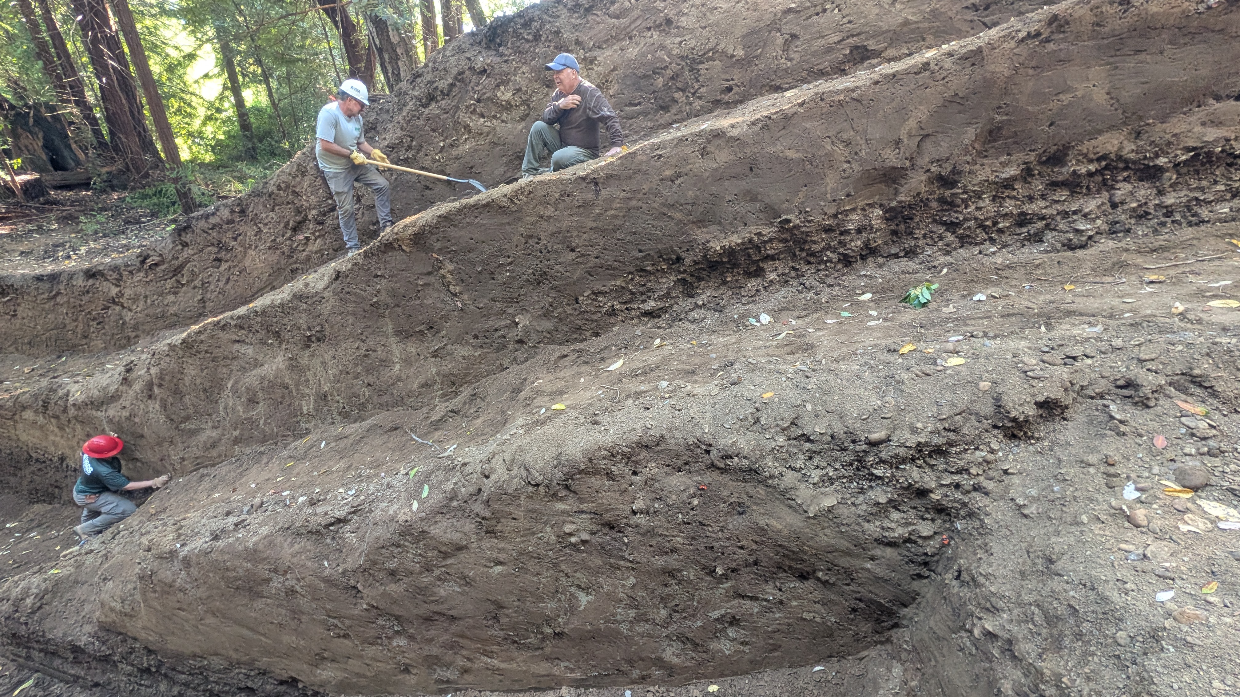
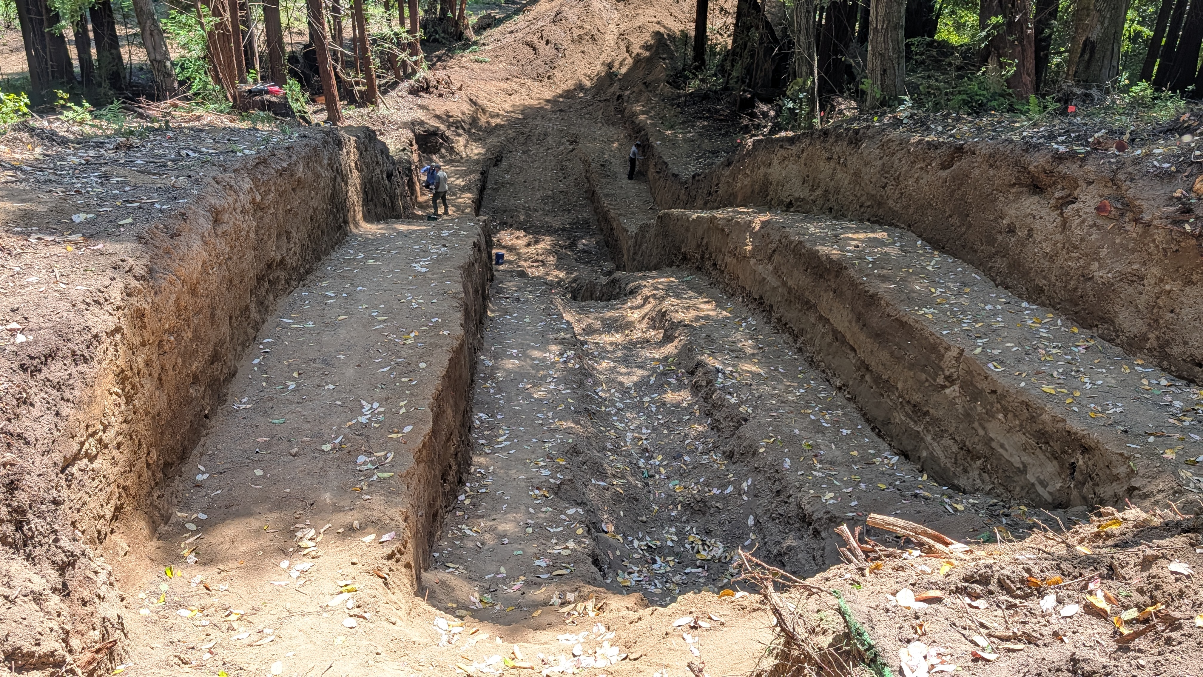
Trenching
Here are some initial photos from our trenching efforts, plus a video.
Here is the trench wall imagery.
We mapped the stratigraphic-structural features atop clear acetate overlain upon imagery plotted at 1:10 scale.
East Wall
West Wall
Trench Review
The Summer Bridge is in!
Most people with four wheel drive can make it the main way in, from exit 671 along the 101 south of Scotia. The directions below first show that path, then show the alternate path (that takes a little longer).
Primary Access
This primary access road has several sections of loose gravel and loose sand. If you are concerned about getting stuck, use the secondary access (see below).
From either north- or south-bound Highway 101, take exit 671 and turn to the East (towards the river).
At the stop sign, turn left towards Pepperwood.
Drive to Pin 1, Shively Flat Road. Turn right after the “Shively” sign.
Follow the gravel road to the left, down the hill, and turn right at the bridge.
Follow the gravel road to the right, southwards, until the road verges to the left to rise up to the first terrace.
Follow the paved road through Shively and park at Pin 02 – Parking Area.
Walk east through the gate and along the gravel road until you reach Pin 03 – Porta Potty.
Turn right down along an unmapped access road and the trench is about 75 meters to the south.
Secondary Access
From the north:
Drive on the 101 about 3 miles south of Scotia and turn left on Pin 04 – Shively Road.
From the south:
Drive on the 101 about 1/2 mile north of Stafford and turn right on Pin 04 – Shively Road.
Follow Shively Road about ten miles and park at Pin 02 – Parking Area.
Walk east through the gate and along the gravel road until you reach Pin 03 – Porta Potty.
Turn right down along an unmapped access road and the trench is about 75 meters to the south.
References
Beeson, J. W., Johnson, S. Y., and Goldfinger, C., 2017, The transtensional offshore portion of the northern San Andreas fault: Fault zone geometry, late Pleistocene to Holocene sediment deposition, shallow deformation patterns, and asymmetric basin growth: Geosphere, v. 13, no. 4
Bold, S. E., 2022, New Mapping of The Goose Lake Fault and Fluvial Terraces at The Yager Creek–Van Duzen River Confluence, Northern California: MS Thesis, Cal Poly Humboldt, 80 pp.
in Patton et al., 2022, The Triangle of Doom V 2.0: Archeology, Stratigraphy, Tectonics, Geomorphology, and Geophysics in the Region of the Mendocino Triple Junction, Friends of Pleistocene, Pacific Cell, Field Trip Guidebook, 235 pp.
Brooks, E., Pennaz, A., and Jurjonas, M., 2023, U.S. Geological Survey risk research community of practice 2021 workshop report—Workshop on considering equitable engagement in research design: U.S. Geological Survey Open-File Report 2023–1072, 25 p., https://doi.org/10.3133/ ofr20231072.
Carver, G. A., Burke, R. M., and Kelsey, H., 1986, Quaternary deformation in the region of the Mendocino triple junction: U.S. Geological Survey.
Carver, G.A., and Burke, R. M., 1988, Trenching Investigations of Northwestern California Faults Humboldt Bay Region: National Earthquake Hazard Reduction Program Final Report: U.S. Geological Survey, 1-53 pp.
Clark, K. J., Nissen, E. K., Howarth, J. D., Hamling, I. J., Mountjoy, J. J., Ries, W. F., Jones, K., Holdstein, S., Cochran, U. A., Villamore, P., Hreinsdottir, S., Litchfield, N. J., Mueller, C., Berryman, K. R., and Strong, D. T., 2017, Highly variable coastal deformation in the 2016 MW7.8 Kaikōura earthquake reflects rupture complexity along a transpressional plate boundary: Earth and Planetary Science Letters, v. 474, p. 334-344.
DeMets, C. and Merkouriev, S., 2016, High-resolution reconstructions of Pacific–North America plate motion: 20 Ma to present in GJI, v. 207, p. 741-773, https://doi.org/10.1093/gji/ggw305
Dietrich, W., 2014, Critical Zone Observatory: Eel River LiDAR Data Collection and Processing, National Center for Airborne Laser Mapping.
Goldfinger, C., Grijalva, K., Burgmann, R., Morey, A. E., Johnson, J. E., Nelson, C. H., Gutierrez-Pastor, J., Ericsson, A., Karabanov, E., Chaytor, J. D., Patton, J., and Gràcia, E., 2008, Late Holocene Rupture of the Northern San Andreas Fault and Possible Stress Linkage to the Cascadia Subduction Zone: Bulletin of the Seismological Society of America, v. 98, no. 2, p. 861-889.
Goldfinger, C., Nelson, C. H., and Johnson, J. E., 2003, Holocene Earthquake Records from the Cascadia Subduction Zone and Northern San Andreas Fault Based on Precise Dating of Offshore Turbidites: Annual Reviews of Earth and Planetary Sciences, v. 31, p. 555-577.
Goldfinger, C., Nelson, C. H., Morey, A., Johnson, J. E., Gutierrez-Pastor, J., Eriksson, A. T., Karabanov, E., Patton, J., Gràcia, E., Enkin, R., Dallimore, A., Dunhill, G., and Vallier, T., 2012, Turbidite Event History: Methods and Implications for Holocene Paleoseismicity of the Cascadia Subduction Zone: U.S. Geological Survey.
Gulick, S. P. S., and Meltzer, A. S., 2002, Effect of the northward-migrating Mendocino triple junction on the Eel River forearc basin, California: Structural evolution: GSA Bulletin, v. 114, no. 12, p. 1505-1519.
Hemphill-Haley, M.A., and Witter, R.C., 2007. Latest Pleistocene paleoseismology of the southern Little Salmon Fault, Strong’s Creek, Fortuna, California, Final Technical Report, U. S. Geological Survey, 19 pp.
Kelsey, H., and Carver, G. A., 1988, Late Neogene and Quaternary Tectonics Associated with Northward Growth of the San Andreas Transform Fault, Northern California: Journal of Geophysical Research, v. 93, no. B5, p. 4797-4819
Ladinsky, T., et al., 2020. In Southern Cascadia, Do Upper Plate Faults Rupture in Concert with Subduction Zone Earthquakes: A Paleoseismic Investigation of the Little Salmon Fault Zone, Final Technical Report, U.S. Geological Survey, National Earthquake Hazard Reduction Program Final Technical Report, 39 p., NEHRP G19AP00045 & G19AP00046
Litchfield, N. J., Villamoor, P., Van Dissen, et al., 2018, Surface Rupture of Multiple Crustal Faults in the 2016 Mw 7.8 Kaikoura, New Zealand, Earthquake: BSSA, v. 108, no. 3B, p. 1496-1520
Ludwig, K.A., Ramsey, D.W., Wood, N.J., Pennaz, A.B., Godt, J.W., Plant, N.G., Luco, N., Koenig, T.A., Hudnut, K.W., Davis, D.K., and Bright, P.R., 2018, Science for a risky world—A U.S. Geological Survey plan for risk research and applications: U.S. Geological Survey Circular 1444, 57 p., https://doi.org/10.3133/cir1444.
McKenzie, K.A. and Furlong, K.P., 2021. Isolating non-subduction-driven tectonic processes in Cascadia. Geoscience Letters, 8(1), pp.1-12.
McCrory, P. A., 1996, Evaluation of fault hazards, northern coastal California: USGS Open-File Report 96-656.
-, 2000, Upper plate contraction north of the migrating Mendocino triple junction, northern California: Implications for partitioning of strain: Tectonics, v. 19, no. 6, p. 1144-1160.
McLaughlin, R. J., Ellen, S. D., Blake, M. C., Jayko, A. S., Irwin, W. P., Aalto, K. R., Carver, G. A., and S.H., C. J., 2000, Geology of the Cape Mendocino, Eureka, Garberville, and Southwestern Part of the Hayfork 30 x 60 Minute Quadrangles and Adjacent Offshore Area, Northern California: USGS, Miscellaneous Field Studies Map MF-2336.
McLaughlin, R. J., Sarna-Wojcicki, A. M., Wagner, D. L., Fleck, R. J., Langenheim, V. E., Jachens, R. C., Clahan, K., and Allen, J. R., 2012, Evolution of the Rodgers Creek-Maacama right-lateral fault system and associated basins east of the northward-migrating Mendocino Triple Junction, northern California: Geosphere, v. 8, p. 342-373.
Merritts, D., and Bull, W. B., 1989, Interpreting Quaternary uplift rates at the Mendocino triple junction, northern California, from uplifted marine terraces: Geology, v. 17, p. 1020-1024.
Millard, A.R., 20114, Conventions for reporting Radiocarbon Determinations, in Radiocarbon, v. 56, no. 2., p. 555-559, https://doi.org/10.2458/56.17455
Ogle, B. A., 1953, Geologic map of the Eel River Valley area, California, California Division of Mines and Geology, Bulletin 164, p. 128.
Padgett, J.S., Kelsey, H.M., and Lamphear, D., 2019, Upper-plate deformation of Late Pleistocene marine terraces in the Trinidad, California, coastal area, southern Cascadia subduction zone: Geosphere, v. 15, no. 4, p. 1323–1341, https://doi.org/10.1130/GES02032.1
Patton, J.R., Hemphill-Haley, M.A., and Streig, A., 2022 A, Tectonic Offset of Latest Pleistocene Fluvial Terrace Treads in Shively, Humboldt County, California in Patton et al., 2022, The Triangle of Doom V 2.0: Archeology, Stratigraphy, Tectonics, Geomorphology, and Geophysics in the Region of the Mendocino Triple Junction, Friends of Pleistocene, Pacific Cell, Field Trip Guidebook, 235 pp.
Patton, J.R., Hemphill-Haley, M., McPherson, R.C., Michalak, M.J., and Nicovich, S., 2022 B, The Triangle of Doom V 2.0: Archeology, Stratigraphy, Tectonics, Geomorphology, and Geophysics in the Region of the Mendocino Triple Junction, Friends of Pleistocene, Pacific Cell, Field Trip Guidebook, 235 pp., http://www.fop.cascadiageo.org/pacific_cell/2022/2022_PAC_CEL_FOP_GUIDEBOOK.pdf
Petersen, M. D., Moschetti, M. P., Powers, P. M., Mueller, C. S., Haller, K. M., Frankel, A. D., Zeng, Y., Rezaeian, S., Harmsen, S. C., Boyd, O. S., Field, N., Chen, R., Rukstales, K. S., Luco, N., Wheeler, R. L., Williams, R. A., and Olsen, A. H., 2014, Documentation for the 2014 update of the United States national seismic hazard maps: U.S. Geological Survey.
Stallman, J. D., and Kelsey, H. M., 2006, Transient geomorphic response to late Pleistocene base level change and climate forcing in the southern Cascadia thrust-and-fold belt, north coastal California in Hemphill-Haley, M., McPherson, R., Patton, J. R., Stallman, J., Leroy, T. H., Sutherland, D., and Williams, T. B., eds., 2006 Pacific Cell Friends of the Pleistocene Field Trip Guidebook, The Triangle of Doom: Signatures of Quaternary Crustal Deformation in the Mendocino Deformation Zone (MDZ) Arcata, CA.
Streig, A. R., Weldon II, R. J., Biasi, G. P., Dawson, T. E., Gavin, D. G., and Guilderson, T. P., 2020, New Insights into Paleoseismic Age Models on the Northern San Andreas Fault: Charcoal Inbuilt Ages and Updated Earthquake Correlations in BSSA, v. 110, no. 3, p. 1077-1089, https://doi.org/10.1785/0120190307
USGS, 2019, Northern California 3DEP QL1 QL2 LiDAR Acquisition USGS The National Map.
Wells, D. L., and Coppersmith, K. J., 1994, New empirical relationships among magnitude, rupture length, rupture width, rupture area, and surface displacement: Bulletin of the Seismological Society of America, v. v. 84, p. P. 974-1002.
Williams, T. B., Kelsey, H. M., and Freymueller, J. T., 2006, GPS-derived strain in northwestern California: Termination of the San Andreas fault system and convergence of the Sierra Nevada–Great Valley block contribute to southern Cascadia forearc contraction: Tectonophysics, v. 413, no. 3-4, p. 171-184, https://doi.org/10.1016/j.tecto.2005.10.047
Witter, R.C., Patton, J.R., Carver, G.C., Kelsey, H.M., Garrison-Laney, C., Koehler, R.D., and Hemphill-Haley, E., 2001, Upper-Plate Earthquakes on the Western Little Salmon Fault and Contemporaneous Subsidence of Southern Humboldt Bay Over the Past 3,600 Years, Northwestern California. U.S. Geological Survey, National Earthquake Hazard Reduction Program Final Technical Report, 44 p., NEHRP 01-HQ-GR-0125
Witter, R.C. and Patton, J.R., 2006. Upper-Plate Earthquakes on the Western Little Salmon Fault and Contemporaneous Subsidence of Southern Humboldt Bay Over the Past 3,600 Years in Hemphill-Haley, M., McPherson, R., Patton, J. R., Stallman, J., Leroy, T. H., Sutherland, D., and Williams, T. B., eds., 2006 Pacific Cell Friends of the Pleistocene Field Trip Guidebook, The Triangle of Doom: Signatures of Quaternary Crustal Deformation in the Mendocino Deformation Zone (MDZ) Arcata, CA.
Woodward-Clyde Consultants, 1980, Evaluation of the potential for resolving the geologic and seismic issues at the Humboldt Bay Power Plant Unit no. 3, Appendices, Woodward-Clyde Consultants, Walnut Creek, California
Xu, W., Feng, G., Meng, L., Zhang, A., Ampuero, J. P., Burgmann, R., and Fang, L., 2018, Transpressional Rupture Cascade of the 2016 Mw 7.8 Kaikoura Earthquake, New Zealand: Journal of Geophysical Research: Solid Earth, v. 123, no. 3, p. 2396-2409, https://doi.org/10.1002/2017JB015168