ALERT
This page is in the process of being rebuilt following the migration to a new web service.
Below is an online version of the PDF here.
ABSTRACT
I investigate evidence of coseismic subsidence in southern Humboldt Bay and the relation of this subsidence to Cascadia subduction zone earthquakes and to earthquakes on the Little Salmon fault, an active upper plate thrust fault that borders Humboldt Bay. Coseismic subsidence at Hookton Slough is correlated with paleo earthquakes at Swiss Hall, ca. 1 kilometer to the east. I identified five buried marsh soils over a 1-kilometer long transect along Hookton Slough, a tidal channel tributary in Humboldt Bay. Using the lateral extent of burial, the abrupt upper contacts to the soils, and the diatom biostratigraphy, soils subsided coseismically and those soil burials were accompanied by abrupt rises in relative sea level. I also infer that tsunami-transported sand, observed in the stratigraphy from Hookton Slough, was deposited directly on two soils at the time of subsidence. Buried soils at Hookton Slough are best explained by coseismic subsidence during Cascadia subduction zone earthquakes. Radiocarbon age estimates constrain timing of subsidence and allow me to estimate a recurrence interval of Cascadia subduction zone earthquakes in the Humboldt Bay region. A recurrence interval for these large earthquakes ranges from 650 to 720 years for the last 2,400 years. Three of the buried soils correlate to similar buried soils found at other sites around Humboldt Bay, and timing of subduction zone earthquakes at Hookton Slough overlaps with timing of earthquakes on the Little Salmon fault.
INTRODUCTION
The principal objective of this study is to identify buried tidal marsh soils in sediments near Hookton Slough and assess whether each soil was buried due to abrupt tectonic subsidence. Timing of the abrupt change is constrained with radiocarbon age determinations. I also investigate whether land level changes are concurrent with tsunamis in the Hookton Slough region. Finally, I attempt to correlate the Hookton Slough earthquake chronology to the regional earthquake history.
Evidence of abrupt land level changes caused by large magnitude earthquakes on the Cascadia subduction zone (Figure 1) can be identified from sediment cores extracted along the margin of Humboldt Bay. This coring study at Hookton Slough provides data to estimate the recurrence of abrupt land level changes and tsunami incursion within South Bay, which is in the southern part of Humboldt Bay (Figure 2), and compares these results with those results of previous studies (Carver and Burke, 1988; Vick, 1988; Clarke and Carver, 1992; Valentine, 1992; Carver and others, 1998; Witter and others, 2002). I provide data on timing and extent of tsunami incursion into the South Bay. Additionally, I correlate Little Salmon fault scarp stratigraphy at the Swiss Hall site to similar stratigraphy further west on the bay margin at Hookton Slough site.


Figure 2. Humboldt Bay – Geologic map of Humboldt Bay region shows upper plate faults and folds. Geology is from McLaughlin etal. (2000). Paleoseismic investigations are summarized here (Shapiro, 1980, Carver and Burke, 1988, Vick, 1988, Carver, 1992, Clarke and Carver, 1992, Li, 1992, Valentine, 1992, Carver, etal., 1996, Leroy, 1999, Vaduro, 2001, Witter, etal., 2000, 2001). Terraces mapped by Carver and Burke are shown for Table Bluff anticline. Faults were mapped by Carver and Burke (1987) and McLaughlin etal. (2000). Locations for sections shown in figure 9 are labeled A, B, and C. Location of figure 4 is indicated by red rectangle labeled Hookton Slough. Fault slip rate table is from Carver and Burke (1992).
The Cascadia subduction zone is an approximately 1,200-kilometer convergent plate boundary that extends from northern California to Vancouver Island, Canada (Figure 1). The Juan de Fuca and Gorda plates are subducting eastwardly below the North American plate. Seismicity, crustal deformation, and geodesy provide evidence that the Cascadia subduction zone is locked and is capable of producing a great (magnitude greater than or equal to 8.5) earthquake (Heaton and Kanamori, 1984; McPherson, 1989; Clarke and Carver, 1992; Hyndman and Wang, 1995; Flück and others, 1997).
Globally, great earthquakes along subduction zones have caused damaging ground shaking, ground rupture by upper-plate crustal faults, liquefaction, turbidites, uplifted marine terraces, and tsunamis (Plafker, 1972; Adams, 1990; Clarke and Carver, 1992; Merritts, 1989; Clague and Bobrowsky, 1994; Satake and others, 1996). Based on buried soil stratigraphy correlated with radiocarbon age data using tree ring wiggle matching and with the inference of a single orphan tsunami in Japan being caused by a single great earthquake, the entire length of the Cascadia subduction zone from Canada to California ruptured in January, 1700 A.D. (Satake and others, 1996; Jacoby and others, 1997; Yamaguchi and others, 1997).
There has been no historic Cascadia subduction zone earthquake along its entire length, but paleoseismic evidence indicates multiple earthquake cycles have occurred along the Cascadia margin over the last 8,000 years (Atwater, 1987; Hemphill-Haley, 1995; Garrison-Laney, 1998; Abramson, 1998; Kelsey and others, 2002; Witter and others, 2003; Figure 1). Evidence for Cascadia subduction zone earthquakes also has been found in Humboldt Bay Holocene stratigraphy in the form of buried soils (Carver and Burke, 1988; Vick, 1988; Clarke and Carver, 1992; Manhart, 1992; Li, 1992; Valentine, 1992; Carver and others, 1998; Leroy, 1999; Witter and others, 2002).
Quaternary deformation around Humboldt Bay has been dominated by contractile deformation due to Gorda – North America plate convergence and from northward Mendocino triple junction migration transpression (Ogle, 1953; McPherson, 1989; Carver and others, 1992b; Smith and others, 1993, and Burger and others, 2002; Williams, 2003). The deformation front of the Cascadia subduction zone lies approximately 75 kilometers offshore of Humboldt Bay (Clarke and Carver, 1992). East of the offshore deformation front is an 85- to 100-kilometer wide fold-and-thrust belt in the accretionary prism, which comes onshore in the Humboldt Bay region (Carver and Burke 1988; Clarke and Carver, 1992; inset Figure 1). Splays of the onshore fold and thrust belt include the Little Salmon fault and the Mad River fault zones (Fig 2). Transpression from Mendocino triple junction migration extends northward to at least the Table Bluff anticline (Burger and others, 2002).
Evidence for Holocene onshore tectonic activity includes (1) earthquakes on upper-plate faults of the Little Salmon fault in Salmon Creek valley and the Mad River fault zone in McKinleyville and Blue Lake (Carver and Burke, 1988), (2) sudden uplift of sections of the coast at Clam Beach (Figure 2) and Cape Mendocino (Figure 1; Clarke and Carver, 1992; Merritts, 1989, Stein and others, 1993, Carver and McCalpin, 1996), and (3) sudden subsidence along margins of Humboldt Bay and Eel River valley (Vick, 1988; Clarke and Carver, 1992; Li, 1992; Manhart, 1992; Valentine, 1992).
This study was conducted in estuarine deposits along the north flank of Table Bluff anticline, south of Hookton Slough. The Table Bluff anticline is the result of growth of an east-west striking north dipping blind reverse fault (Figure 2). Fault propagation folding is evident from onshore deep-penetration seismic profiles (Carver, 1992). However, evidence of right-lateral strike-slip offsets of about 2-kilometers along a near vertical fault associated with the Table Bluff anticline is found in 1996 seismic profiles (Burger and others, 2002). The N70-90W Table Bluff anticline is composed of Plio-Pleistocene Wildcat Group sediments draped by a flight of marine terraces of Quaternary Hookton Formation consisting of fluvial to near-shore and beach sediments (Carver and Burke, 1992; Figure 2). Each abrasion platform is associated with a stable relative sea level high during an interglacial period. Since 332 ka anticlinal growth intersected with sea level highs and abrasion platforms were cut into the fold (Burger and others, 2002). Terraces mapped by Carver and Burke (1992) have younger terraces cut into the margins of Table Bluff; these younger terraces are directly south of Hookton Slough. Modern tidal flats may be overlying still younger abrasion platform(s). Hookton Slough, a tidal channel, cuts into these tidal flats and was probably formed from discharge of the largest tributary of southern Humboldt Bay, Salmon Creek.
Hookton Slough core sites are in a low-lying brackish marsh that mostly exists below mean

Figure 3. Hookton Slough core location map. – Core locations are displayed as blue dots. White circles highlight vibra core locations. West, Center, and East transects are separated by historic tidal channels in green. 1912 high tide line in blue shows that all core locations were tidally inundated pre-levee construction (Coast and Geodetic Survey, chart 18622, 1912). Tide gates permit partial saline influence to study area. Imagery is USGS false color infrared Digital Orthophoto Quarter Quadrangle, Fields Landing, 1989, with one meter pixels. Figure 7 photo point is shown along boat ramp.
higher high water (Figure 3). Levees constructed up to the late 1920s (Shapiro and others, 1980) now prevent tidal inundation to core sites. However, portions of the study area are perennially submerged because levees restrict drainage of ground and surface water. At times the study site becomes flooded

Figure 4. Panorama of HS site – View is from the north end of the boat ramp road, at the apex of the levee. Photo point location is on figure 2. The above view is the site during summer and the below view is the site during high flows in Salmon Creek.
with as much as two meters of standing water (Figure 4), and flooding contributes to the preservation of subsurface stratigraphy. In contrast, Valentine (1992) found that interpretation of Humboldt Bay stratigraphy in most areas immediately behind levees was impeded by oxidation in the upper 1 to 1.5 meters.
METHODS
Paleoseismic investigations provide data on earthquake history. Atwater (1987) first suggested evidence of coseismic deformation of late Holocene estuarine deposits along the coast of Washington. Atwater (1987); Clarke and Carver (1992); Clague and Bobrowsky (1994); Nelson and others (1996a, 1996b, 1998); Hemphill-Haley (1995); Atwater and Hemphill-Haley, (1997); Kelsey, and others (2002); and Witter and others (2003) interpret mid- to late-Holocene buried tidal marsh soils to be caused by vertical land-level changes related to Cascadia subduction zone earthquakes. Since buried soils are not exposed in cut banks in southern Humboldt Bay, research on buried soils requires coring in tidal marshes.
Subsurface stratigraphy was determined with a core transect located parallel to Hookton Road (Figure 3). This allowed me to contour the pre-historic margin of southern Humboldt Bay just east of the Hookton Road boat ramp (Figure 4). All locations were surveyed with a total station to determine precise core positions (Appendix A). USGS (PID LV0658) and California Department of Transportation (PID K1087) benchmarks were used as horizontal datums. A NOAA (PID K1087) tidal benchmark was incorporated in the survey, allowing tie-in of elevations to the local tidal datum (NOAA, 2000).
Closely spaced borings are required to correlate stratigraphy among cores. Fifty-three, 3-centimeter diameter gouge cores were hand driven to sample subsurface stratigraphy along the one kilometer transect: West, Center, and East Sections (Figure 3). The cores were driven down to 6 meters depth or until resistance by coarse sediment (pebbles up to 3-centimeter diameter) prevented further penetration. The core transect is sub-parallel to the break in slope, along the historic high tide line. Three main sub-transects, West, Center, and East sections, are separated by historic channels (blue lines; Figure 3). There are three slope-perpendicular profiles, one in each sub-transect, labeled Profiles A-A’, B-B’, & C-C’ (Figure 3). Core stratigraphy of slope-perpendicular transects shows that the buried deposits lap onto upland stratigraphy to the south.
Stratigraphy within each core was recorded by color, texture, structure, roots, and nature of contact. Distinct horizons were correlated among cores based on lithostratigraphy and depth.
In addition to gouge cores, vibra cores (7.5-centimeter diameter aluminum tubes) were taken at sites where gouge cores had the most complete stratigraphic section. Vibra cores are driven into the ground by vibrating the tubing with a gasoline engine and are removed from the ground with a ratcheting winch. In contrast to gouge cores, vibra cores provide larger quantities of sample for paleoenvironmental and radiocarbon analysis. Also, variation in the nature of the contacts between strata is clearer with the larger cross sectional area of the vibra cores.
Fossil diatoms sampled from specific strata in vibra cores are used to infer changes in paleoenvironment relative to mean tidal level. Paleoenvironmental interpretation is based on the observation that Humboldt Bay organisms live in tidal range-restricted habitats based on salinity (Li, 1992; Manhart, 1992; Carver and others, 1998). Hemphill-Haley (1995) developed techniques to estimate paleoenvironment based on diatom assemblages in Willapa Bay, Washington using the Brackish Intertidal Diatom Index (BIDI). The BIDI is a ratio of the counts of groups of diatoms based on their modern tidal range and provides a qualitative estimate of paleoenvironment. BIDI values range from zero, inferring a sub-tidal environment, to one, inferring a more freshwater, high-marsh environment.
Diatom samples were chosen immediately above and below the top of the buried soil to test the abruptness of environmental change. Samples were also chosen several centimeters above and below the contact to test that the samples represent the paleoenvironment of the sampled unit. A sample is chosen more distant up section from the contact to test the permanence of the environmental change.
If buried soils are to be considered evidence for coseismic subsidence, there are five criteria that could be satisfied (Nelson, 1996b). They include (1) suddenness of submergence, (2) submergence greater than or equal to 0.5 meters, (3) lateral extent of submergence over hundreds of meters, (4) coincidence of submergence with tsunami sands, and (5) synchronous submergence of correlative buried soils. In addition, Hemphill-Haley (1995) suggests three additional criteria: a significant change in diatom assemblage across stratigraphic contact inferring a sudden change in land elevation, submergence indicated by the persistence of environmental change, and the presence of sand flat diatom species in the sand capping the mud. In this study not all five criteria were satisfied in order to demonstrate coseismic subsidence.
Age control for deposits is constrained using accelerator mass spectrometry 14C age estimates (Jacoby and others, 1995; Nelson and others, 1996b; Atwater and Hemphill-Haley, 1997). Only identifiable plant material was used for age control. While detrital material provides a maximum limiting age, in situ material provides a minimum limiting age. Samples that likely persist through time (large chunks of wood, charcoal) were not chosen because they are more likely to be reworked, thus overestimating the age of the deposit. Radiocarbon samples were first wet-sieved with a #100 (0.5 millimeter) screen, then identified, and then dried and sent to Geochron Laboratories for accelerator mass spectrometry 14C analyses. Finally, radiocarbon age determinations were converted from lab reported radiocarbon years to calendar years to constrain the timing of inferred earthquakes and tsunamis.
RESULTS
The Hookton Slough cores show evidence of soils recurrently buried suddenly by mud to muddy peat. Sandy deposits abruptly overlie three buried soils. Abrupt and persistent paleoenvironment change as inferred from diatom analysis accompanies the abrupt and persistent lithostratigraphic change. Accelerator mass spectrometry 14C age estimates constrain the timing of these changes.
Lithostratigraphy
Hookton Slough cores show cycles of peat that are commonly first overlain by sandy


deposits and then overlain by muds (Table 1). Correlation of units among closely spaced cores is based on stratigraphy (Figs. 5a, b, c, and 6).
Five buried muddy-peat to peat horizons are found (buried soils 1-5, Table 1). Soil 1 is the most recent buried soil and soil 5 is the

Figure 5. Gouge Core Stratigraphic Sections – Stratigraphy for fifty-three gouge cores is shown in these three figures. Relative core location map with scale bar is on top. Texture is plotted as width of stratigraphic column, as shown in explanation. Laboratory reported 14C ages are designated with an inverse triangle. Peat numbers are in enclosed circles. Tsunami deposits are labeled with a circled “t.” Ranges of buried peat upper contacts are shown by colored rectangles on the right. Slope perpendicular transect cores are labeled by A-A’, B-B’, and C-C ’.
oldest buried soil. The soils are abruptly buried by either muds (soils 5 and 2) or by sands (soils 1, 3, and 4). The soils contain up to 100% fibrous peat.

The mud found between the buried soils has an abrupt (< 2 cm) lower contact (Figure 7)

and a gradual (5 to 15 cm) upper contact. The abrupt lower contact indicates a rapid stratigraphic change and the gradual upper contact indicates a slower stratigraphic change. The mud consists of silty clay to silt loam (Table 1). Thickness of mud between soils 3 and 4 is greater and more variable than the thickness of the mud between soils 2 (or 1) and 3 (Figs. 5a, b, and c). Rhyzoconcretions (stiffer mud surrounding root pores, commonly reddish brown in color, possibly due to iron oxidation) were found between soils 2 and 3. Underlying rhyzoconcretions were millimeter scale black laminations.
The sand overlying soils 3 and 4 commonly consists of multiple normally graded beds of sand to sandy loam. The sand’s lower contact is abrupt, often with a wavy 1- to 4-centimeter relief. Commonly incorporated within the sand are 0.5- to 3-centimeter diameter rip-up clasts consisting of pieces of mud and pieces of fibrous peat (possibly from the underlying soil; Figure 7).

Figure 6. Vibra-core stratigraphic sections – Hookton Slough vibra-core stratigraphy for nine vibra-cores is displayed in a photographic mosaic. On map circles indicate Core locations. Triangles mark location of age control samples. BIDI value labels fossil diatom sample locations. Photo mosaic for each column is composed of six to fifteen overlapped photos. Peats are labeled with encircled numbers. Tsunami deposits are shown with encircled “t.” Elevation is related to MLLW for NOAA tidal benchmark K1087.

Figure 7. Close-up of core 26 – Close-up of view of srata in vibra-core 26 interval 147-174 cm. Fibrous peat is overlain by coarse sand to pebble deposit with up to 1cm diameter fibrous peat and silt loam rip up clasts along an abrupt wavy contact. Sand is gradually overlain by silt loam.
Coarse gravelly sand to sandy loam defines the depth of core refusal, which ranges from 1.5 to 6.1 meters depth (Figs. 5a, b, c, and 6). These sediments are blue gray at the top and change downward to orange tan. I interpret these deposits to be colluvium from the Pleistocene Hookton Formation, found in outcrop directly upslope to the south of the coring transect. In cores proximal to the upland, soil 4 is commonly developed in the top of this unit (Figure 8).

Figure 8. Lithostratigraphy and Biostratigraphy figure – Brackish Intertidal Diatom Index (BIDI), developed by Hemphill-Haley (1995), data for samples from Hookton Slough stratigraphy are shown in relation to depth. In conjunction with angular unconformities above peats three and four, an abrupt change in inferred paleoenvironment occurs. Secondly, the environmental change is persistent. Orange line depicts an environmental change that is not persistent.
Soil 5, found deeper in a core further north (away from the upland) is developed in mud also overlying this unit.
Biostratigraphy
Based on plants (Triglochin) and diatom assemblages, soils found at Hookton Slough were likely developed in high marsh to upland environments and muds were deposited in low marsh environments (Figure 9).

Figure 9. Broadness and Other Factors – Circles designate core locations of cores that satisfy broadness criteria for earthquake mechanisms. 1912 (C&GS, 1912) tidal channel is shown for unit “tsunami 4” to relate topographic position to unit preservation. Figure 8b cores 18 and 30 are located near 1912 tidal channels. Tsunami deposits are preserved in cores distant to tidal channels.
Environmental change inferred from fossil diatoms in cores 5A and 49 (analysis by Eileen Hemphill-Haley, Appendices B and C) reflects a high marsh to upland paleoenvironment abruptly changing to a tidal flat paleoenvironment for burial of soil four and a low marsh paleoenvironment to tidal flat paleoenvironment for burial of soil three (Appendices C and D; Figure 9). The abrupt change in inferred environment correlates with abrupt lithostratigraphic change. A freshwater paleoenvironment of the coarse gravelly sand to sandy loam below the buried soils is based on diatoms and the presence of phytoliths.
Radiocarbon Age Determinations
Hookton Slough buried soils 1, 3, and 4 contained materials suitable for radiocarbon age determinations (Table 2).

Age control is poor to non-existent for soils 1 and 2. A radiocarbon age for soil 1, using a sample of more than forty seeds, is 100 ± 40 14C yr BP (BP = before A.D. 1950). This radiocarbon age (Figure 10) is consistent with the inference that the soil subsided during the A.D. 1700 Cascadia subduction zone earthquake; but the calibrated age range (A.D. 1950 to A.D. 1677) is broad. Soil 2 did not contain material suitable for age determination. The ten radiocarbon age determinations for soil 3 include three which are based on seeds, one based on a twig with bark, and six based on triglochin leaf bases (Table 2; Figure 10). The seven soil 4 radiocarbon ages include two of which are from seeds, one from a conifer leaf, one from a twig with bark, two from vascular plant leaves,

Figure 10. 14C Results with PDF plots for Hookton Slough – All 14C results for Hookton Slough are displayed with probability density functions as determined with OxCal calibration software (1999?). X-axis is time, Y-axis is sample probability function of each sample, sorted by age with color, and labeled by sample number. Sample number syntax for ‘48 215.5 1990±40BP’ is (48) core number; (215.5) depth to top of sample interval; (1990) laboratory reported age; (±40) laboratory error; (BP) designates the year (1953) from which the lab reported age is measured from. Interpreted age ranges for coseismic burial of peats one, three, four, and five, are delineated by gray rectangles by aligning overlapping two sigma ranges for selected age estimates. Distance to contact is the minimum and maximum distance between the sample intervals upper and lower contact and the contact between the upper or lower unit. An ‘up’ arrow depicts a sample from below a contact. A ‘down’ arrow depicts a sample from above a contact. Atmospheric data from Stuiver et al. (1998); OxCal v3.5 Bronk Ramsey (2000).
and one based on an in situ triglochin rhizome (Table 2; Figure 10). The two soil 5 age determinations are from detrital material from the same horizon in the same core and provide the same ages (Table 2; Figure 10).
DISCUSSION
Subsidence Mechanism
Criteria used to infer coseismic subsidence of the five soils identified from cores in Hookton Slough include: 1) suddenness of change in depositional environment, 2) amount of subsidence, 3) lateral extent, 4) presence of sand capping peat, and 5) synchroneity of buried soils (Nelson, 1996b; Hemphill-Haley, 1995). These criteria are satisfied robustly for three of the five soils.
Buried soil 1 is laterally extensive, it was found in 44 cores (83% of all cores; Figure 11;

Figure 11. PDF plots of sequence analysis – OxCal procedures for X2 test is called “combine.” Results are plotted with an average PDF. Bayseian statistics assume stratigraphic superposition. OxCal uses Sequence analysis for this procedure.
Table 3).
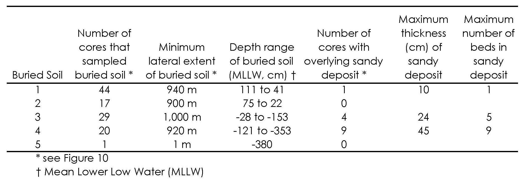
The upper contact of soil 1 is abrupt, wavy, and overlain by sand and mud commonly with rip up clasts of mud, peat, and peaty mud. The upper contact of buried soil 1 is similar in abruptness and relief to upper contacts for soil 3 and soil 4. I infer that soil 1 was buried coseismically based on the abruptness of the upper soil contact, the laterally extensive preservation of the soil, the presence of an overlying sandy deposit, and the synchroneity of this burial.
Soil 2 is preserved in only 17 cores (40% of all cores) and is laterally extensive along 900 meters of the Hookton Slough core transect (Figure 11, Table 3). The upper contact to soil 2 is abrupt in all cores. Diatom samples were not collected, so paleoenvironmental change based on diatom paleoecology was not inferred for burial of this soil, therefore neither the change in environment nor the degree of subsidence can be evaluated. Soil 2 possibly was coseismically buried based on criteria 1, 3, and 5.
Buried soil 3 satisfies all criteria for burial by coseismic subsidence. Soil 3 has an abrupt upper contact in all cores that contain soil 3 (55% of all cores). Fossil diatom data show an abrupt change in paleoenvironment in conjunction with an abrupt lithostratigraphic contact (Figure 9). Buried soil 3 is laterally extensive along 1,000 meters of the core transect and sand caps the soil in 14% of cores that contain soil 3 (Table 3). I interpret this soil to represent a marsh that was buried coseismically and immediately inundated by a tsunami based on the sand directly overlying the buried soil.
Buried soil 4 also satisfies all criteria for burial by coseismic subsidence. The upper contact is abrupt in all of cores that contain soil 4 (38% of all cores). Diatom counts infer an abrupt change in paleoenvironment in conjunction with the abrupt upper contact (Figure 8). Buried soil 4 is laterally extensive along 920 meters of the core transect and sand caps the soil in 45% of cores that contain soil 4 (Figure 11; Table 3). I interpret that soil 4 was buried coseismically and soil burial coincided with a tsunami.
Soil 5 has the least criteria for satisfying burial by earthquake-induced subsidence. This soil was found in only one core, where the upper contact was abrupt and overlain by mud. Based solely on criteria 1, this soil may have been coseismically buried.
Possible alternative explanations for all soil burials include cut-and-fill by tidal streams, sediment deposition by storms or floods, fluctuations in sea level, or intermittent closure of the mouth to Humboldt Bay. None of these alternative explanations is supported by field data.
For example, extensive lateral continuity of the buried soils’ upper contacts eliminates tidal stream cut-and-fill as a mechanism for stratigraphy found at Hookton Slough. Cut-and-fill by tidal streams would produce stratal contacts with a relief equal to the depth of stream scour. The upper contact of buried soil 3 has a low relief (0.5 meter). The thickness of soil 4 is also consistent throughout the relief of the upper contact. This suggests that the disconformity is unlikely to have been caused by localized erosion across the contact due to tidal streams.
It is unlikely that storms or floods were the cause of soil burial at Hookton Slough because sediment deposition during storms or floods would increase the ground elevation. To the contrary, fossil diatoms observed in stratigraphy at Hookton Slough show a lowering in elevation across the peat-mud contact. However, due to a lack of paleontological evidence, there is greater uncertainty about whether soil 1 or soil 2 were buried by storm or flood deposits.
Fossil diatom changes are consistent with an abrupt long-lasting rise in relative sea level and not with sea level fluctuations occurring over periods of months to decades for burial of soils three and four. Furthermore, upper contacts of the buried soils at Hookton Slough are abrupt, and therefore are unlikely to be a response to gradual sea-level fluctuation.
Bay-mouth barrier formation and breaching may explain mud overlying soils, but all maps since 1852 show the mouth in the current location. In the last 150 years the mouth has always stayed open (up to twenty meters depth in 1894, United States Coast and Geodetic Survey). Even though this amount of time is short when compared to the stratigraphic record found at Hookton Slough, this evidence shows that in historic times the mouth is in equilibrium with the relations between freshwater discharge into the bay, tidal exchange of sea-water, and sediment budget for the littoral cell of Humboldt Bay.
Fluvial discharge from tributaries into Humboldt Bay is probably sufficient to maintain the bay mouth. In Willapa Bay, Washington, Atwater and Hemphill-Haley (1997) suggest there may be too much freshwater discharge into the bay to allow deposition of a sand barrier across the bay mouth. Elk River, Freshwater Creek, Jacoby Creek, Jolly Giant Creek, Salmon Creek, and other tributaries into Humboldt Bay generate sufficient discharge to maintain the mouth. If the bay mouth were closed for a sufficient time, freshwater diatoms would be found in the mud capping the soils, whereas Hookton Slough fossil diatoms are consistent with a continuous tidal environment for the last 2,400 years.
In summary, abrupt and persistent lithostratigraphic and biostratigraphic changes coincide in sufficient frequency and over a sufficiently broad area (at least 48,000 m2) to verify the inference that several tidal marsh soils at Hookton Slough were buried by coseismic subsidence accompanying Cascadia subduction zone earthquakes. I conclude that coseismic subsidence occurred five times in the Hookton Slough region in the last 3,700 years.
Subsidence Magnitude
Estimates of subsidence magnitude may be made using two methods: the paleoelevation estimate and the pre-burial ground surface relief estimate. Paleoenvironment based on fossil diatoms is used to estimate paleoelevation range (Kelsey and others, 2002; Witter and others, 2003; Table 4; Figure 12).
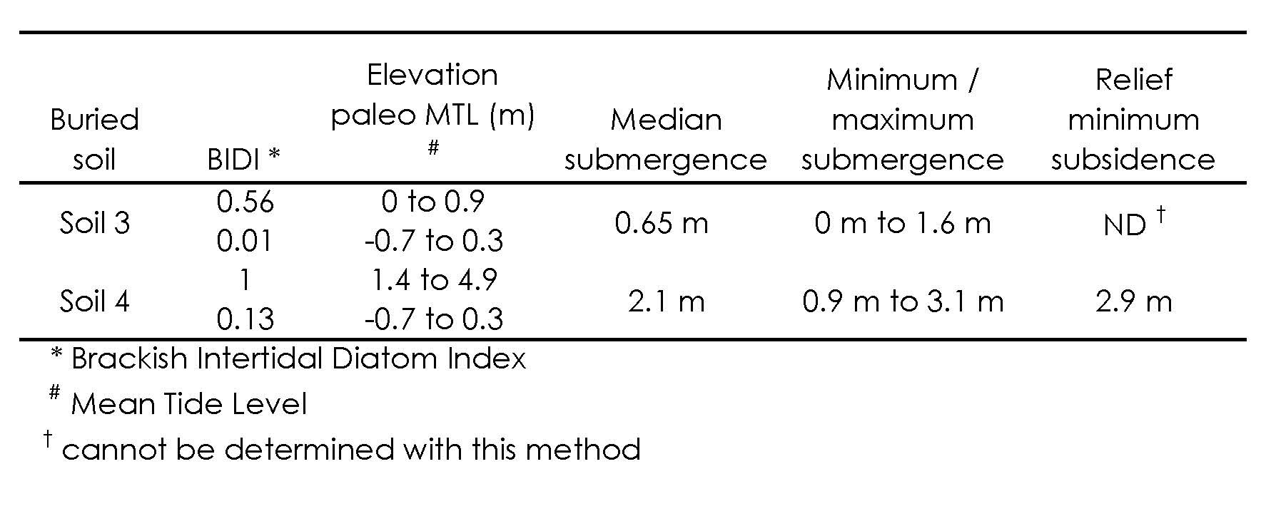
Paleoenvironment is based on elevation relations between modern vascular plants and modern diatom zonation in southern Oregon (Nelson and Kashima, 1993). Changes of paleoelevation are determined by subtracting paleoelevation ranges of the buried soil from the overlying mud (Table 4; Figure 12-A).

Figure 12. Time-Space Diagram for CSz – Age ranges for index studies (Atwater and Hemphill-Haley, 1997, Nelson, 199?, and this study) are plotted along a north south axis. Data plotted are referenced here and can be found in tabular form in Appendix A. Dashed lines are my interpreted tie lines between studies. Horizontal gray bands show age ranges for interpreted segments of the Csz.
Minimum and maximum paleoelevation estimates of submergence for soil 4 are 0.9 and 3.1 meters, respectively. Minimum and maximum paleoelevation estimates of submergence for soil 3 are 0.0 and 1.6 meters, respectively. Because the upland and mudflat elevation ranges are limited to 1 meter by truncating the unbounded upper and lower ends respectively (Figure 12), this method does not measure maximum submergence greater than 3.1 meters. Therefore, the maximum submergence estimate can be larger and is thus a lower limiting maximum.
For estimates using relief measurements, minimum submergence is larger than the paleoelevation method (Table 4). Assuming the relief of buried soil 4’s upper contact represents pre-existing topography, all of soil 4 was in an upland setting, and mud overlying buried soil 4 was deposited in a tidal flat setting (Figure 12). In order to test that all of soil 4 was in an upland setting, diatom paleoenvironment estimates must be made in cores that have soil 4 in the lowest and the highest position. Pre-subsidence elevation of soil 4 is constrained by paleoelevation estimate for sediment sampled from core 5A (Figure 12-B, a). Post subsidence elevation control is based on the highest position for soil 4 being at the highest elevation in the mudflat ecological range (Figure 12-B, c). Minimum submergence estimates are made by subtracting the lowest possible elevation of the topographically highest position of soil 4 in core 5A (pre-subsidence elevation minimum = 3.2-meters MLLW; Figure 12-B, b) from the highest possible elevation of the same highest topographic position of soil 4 in core 5A (post-subsidence elevation maximum = 0.3-meters MLLW; Figure 12-B, c). Modern tidal range is almost as large as the relief of soil 4. Only soil 4 upper contacts are sufficiently large with respect to tidal range to reliably use the relief method for a submergence estimate. The paleoelevation minimum subsidence estimate cannot measure submergence larger than 0.9 meters. Given the uncertainty in paleoelevation estimates for the range of elevations of soil 4, topographically above soil 4 in core 5A, the relief derived minimum submergence estimate for soil 4 is 2.9 meters.
Maximum submergence cannot be completely measured with either method, because upper bounds of upland environments and lower bounds of mudflat environments cannot be constrained. Maximum submergence estimate methods need to be improved to better estimate subsidence maxima. Because the paleoelevation method cannot measure minimum submergence greater than 0.9 meters, the soil relief method is necessary in future studies to make better estimates of submergence in cases where subsidence may be greater than 0.9 meters.
Coarse Sediment Deposition
There are several stratigraphic and paleontologic attributes of the Hookton Slough sandy sediment (“sand”) that lead me to interpret that it is of tsunamigenic origin. These include: 1) the association of sand with an abrupt relative sea level rise, 2) an abrupt erosive lower contact of the sand overlying the buried soils, 3) rip-up clasts of mud and peat are within the sand, 4) the presence of unbroken sand flat diatom species, and 5) the multiple upward fining beds in the sand layers. I interpret that a sand-laden tsunami inundated Hookton Slough following at least two coseismic subsidence events. Rip-up clasts and sand intrusions into the underlying soil imply the tsunami had high flow velocities sufficient to erode the buried soil substrate. Multiple fining-upward sandy beds imply that the tsunami for each earthquake consisted of multiple waves. The coincidence of the tsunami deposits and the soil burial, taken together, support the conclusion that Cascadia subduction zone earthquakes caused the subsidence at Hookton Slough.
In addition to tsunami deposits associated with buried soils 3 and 4 at Hookton Slough, Carver and others (1998) identified tsunami deposits in southwestern Humboldt Bay, six kilometers west of the Hookton Slough site (green dots; Figs. 2 and 13). These deposits thin landward to a few centimeters, and Carver and others (1998) concluded that the tsunami that mobilized these sandy deposits overtopped the sand spit due west of their core sites. It is unlikely that the same tsunami waves carried sediment eastward to Hookton Slough because the Hookton Slough tsunami deposits are thicker, up to 45 centimeters (Table 3). An alternative explanation is that the same tsunami locally overtopped the South Spit, depositing thin sand sheets at the southwest corner of the bay, and simultaneously flowed through the bay mouth and up South Bay tidal channels, depositing thicker tsunami deposits at Hookton Slough (Figure 13).

Tsunamis that concentrate in tidal channels are well documented near Port Alberni, British Columbia (Clague and others, 2000; Figure1).
Ages of Coseismic Subsidence Events
Hookton Slough stratigraphy records at least five coseismic events within the last 3,700 years. Radiocarbon age estimates are made on four of the inferred events (Figure 10). I infer soil 1 was buried during the A.D. 1700 earthquake because the one radiocarbon age includes A.D. 1700 within the range and because trees in northern Humboldt Bay were coseismically drowned in ca. A.D. 1700 (Jacoby and others, 1995).
The ten radiocarbon ages of soil 3 are challenging to interpret because the detrital seed ages, which should provide lower limiting ages, are on average younger than the six triglochin leaf base ages, which should provide upper limiting soil ages because leaf bases grew into the soil. Seed ages could be older (providing a lower limiting age) than rooted herbs ages (providing an upper limiting age) because the herbs may be still alive when the seeds are deposited. Following the 1964 Alaska earthquake induced subsidence, aggradation recovered most of the elevation lost during the earthquake (Atwater and others, 2001). Given similar rapid sedimentation following Hookton Slough earthquakes, seeds found in soil 3 did not translocate downward through the approximately 1 meter thick stiff tidal mud. The seeds would have grown on plants rooted in a similar-aged soil to that which the triglochin was rooted. Therefore, all soil 3 radiocarbon material is probably from the same age population, but the systematics of radiocarbon uptake may be different for dissimilar wetland plant species. Similarly, in a radiocarbon age study for the A.D. 1700 Cascadia earthquake, Nelson and others (1995) found rooted herb ages to be consistently older than ages determined from rooted wood samples. Since there is no way to test which ages are more representative of the age of buried 3 three at Hookton Slough, I choose an age estimate that spans the reported 14C ages after eliminating the one anomalously old age (Figs. 10 and 14). This discarded age is not consistent with the other ages since it is hundreds of years older that the remaining ages.
Although there is no radiocarbon age for soil 2, soil 2 age is likely between 250 and 1,200 years BP because this age is older than A.D. 1700 but younger than soil 3 age (Figure 10).

After eliminating two radiocarbon ages for soil 4 because they are too old, the remaining five radiocarbon ages are averaged to determine a calibrated age range for soil 4 (using OxCal; Bronk Ramsey, 1995, 2001; compare Figs. 10 & 14). These two discarded ages are also inconsistent with the span of the remaining ages. Similarly, the two soil 5 radiocarbon ages are combined to determine one calibrated age range (Bronk Ramsey, 1995, 2001; Figure 14).
In summary (Table 5), I infer five subduction zone earthquakes in the last ca. 3,500 years in southern Humboldt Bay. The most recent was the A.D. 1700 earthquake and the other three age constrained buried soils (3, 4, and 5) record earthquakes in the age windows of 1,350 to 2,150 yrs BP, 2,200 to 2,400 yrs BP, and 3,450 to 3,650 yrs BP respectively (Table 5).

Recurrence Interval for Subduction Zone Earthquakes
A recurrence interval estimate for subduction zone earthquakes causing coseismic subsidence near Hookton Slough is 650 to 720 years. This estimate assumes buried soils 1, 2, 3, and 4 each record a subduction zone earthquake. Three interseismic intervals that span these four soils have a cumulative age span of 1,950 to 2,150 years assuming soil 1 subsided in 250 years BP and soil 4 subsided 2,200 to 2,400 years BP. Three intervals in a 2,200 to 2,400 year period yield a 650 to 720 year recurrence interval.
In comparison to other recurrence interval estimates for Cascadia subduction zone earthquakes from sites that have more that 2,500 years of earthquake record, Hookton Slough recurrence interval estimates are large. Using stratigraphy from sites along much of the entire Humboldt Bay margin, Valentine (1992) estimates a recurrence interval of 220 to 420 years over the last 4,300 years. Kelsey and others (2002) compute a 480 to 585 year recurrence interval at Sixes River estuary, Oregon, using 5,600 years of record, Witter and others (2003) compute a 570 to 590 year recurrence interval at the Coquille River estuary using 6,720 years of record, and Atwater and Hemphill-Haley (1997) compute a 500 to 540 year recurrence interval at Willapa Bay, Washington estuary over the last 3,500 years.
The Hookton Slough recurrence interval estimate of 650 to 720 years may be large compared to sites to the north for several reasons. Hookton Slough stratigraphy may be missing an earthquake in the 250 to 2,000 year period. This ghost earthquake may not be recorded because it did not cause subsidence to be preserved in the strata. Alternatively, earthquakes on the Cascadia subduction zone could have occurred more frequently in the 1,000 to 2,000 year period prior to 2,400 years BP, a time period not recorded at Hookton Slough but recorded in the strata in southern Oregon and southern Washington. Another possibility is that an earthquake may be preserved in the strata but I did not recognize it.
A small sample size may be a limiting factor as well. Perhaps four to eight earthquakes is insufficient to capture the full range of variance for the recurrence of Cascadia subduction zone earthquakes. Future research is necessary to confirm or refute the presence of a ghost earthquake.
Correlation of Hookton Slough Earthquake Record to other Humboldt Bay Paleoseismic Sites and Tectonic Role of Little Salmon Fault
Using radiocarbon ages and stratigraphic relations, I correlate earthquake records at Hookton Slough to other Humboldt Bay paleoseismic sites at Salmon Creek valley (Carver and Burke, 1988; Clarke and Carver, 1992), Swiss Hall (Witter and others, 2002), and Mad River Slough (Vick, 1988; Jacoby and others, 1995)(Figure 15, Appendix E).

I did not use Valentine (1992) radiocarbon ages for correlation in Humboldt Bay because all 14C ages are from bulk peat samples and ages are not systematically older with depth in cores for southern Humboldt Bay (Appendix E).
I consider radiocarbon ages for buried soils at Mad River slough (Vick 1988; Jacoby and others, 1995; Appendix E). Up to four subsidence events are found by Vick (1988). One Mad River Slough earthquake (Mad River Slough event Y, Figure15) correlates with an earthquake at Hookton Slough (Hookton Slough event 1, Figure 15). There are diatom paleoecologic data for the two upper most Mad River slough buried soils (Chad Pritchard, personal communication, 2004) and there are Foraminiferid paleoecologic data for the A.D. 1700 Mad River slough buried soil (Manhart, 1992). Due to lack of paleoecologic data, other buried soils at Mad River slough may not have been caused by an earthquake (Chad Pritchard, personal communication, 2004).
Inferred earthquakes near Swiss Hall (located two to three kilometers east of Hookton Slough) are correlated with inferred coseismic subsidence events at Hookton Slough (Figure 15). At the Swiss Hall site there is evidence for three, and possibly four earthquakes in sediment cores and trenches that crossed the western trace of the Little Salmon fault at the bay margin (events 1, 2, 3, and 4, Figure 15). Based on stratigraphic relations and fossil diatom evidence, Witter and others (2002) conclude that the study site coseismically subsided three times, over an estimated area of at least 5,500 m2 (events 2, 3, and 4, Figure 15). Witter and others (2002) also conclude that the study site also folded the buried soils during at least one event on the Little Salmon fault (event 1, Figure 15). Within radiocarbon error, three buried soils (Hookton Slough events 2, 3, and 4, Figure 15) at Hookton Slough appear to correlate with three buried soils at Swiss Hall (Swiss Hall events 2, 3, and 4, Figure 15). Within radiocarbon error Hookton Slough buried soil 1 correlates to the Swiss Hall folding event 1(Figure 15). At Hookton Slough three of the correlative buried soils (soils 1, 3, and 4) are capped by sand sheets that include multiple graded beds and mud or peat or peaty mud rip-up clasts.
Salmon Creek valley fault trench studies conclude three earthquakes occurred in the last 2,000 years (Figure 15, Appendix E). Within large radiocarbon age determination error, three earthquakes at Hookton Slough (Hookton Slough events 1, 2, and 3, Figure 15.) correlate with three earthquakes at Salmon Creek Valley (Salmon Creek valley events 1, 2, and 3, Figure 15). Salmon Creek valley fault relations record Little Salmon fault history. Hookton Slough strata record Cascadia subduction zone earthquake induced subsidence. If these three earthquakes are correlative, then both Little Salmon fault and Cascadia subduction zone earthquakes coincide. If Hookton Slough is sensitive to both Cascadia subduction zone and Little Salmon fault earthquakes, and Little Salmon fault earthquakes are independent and chronologically distinct, then we would expect more earthquakes in the stratigraphic record at Hookton Slough (which we don’t). Therefore, either 1) Cascadia subduction zone and Little Salmon fault earthquakes are coincident and Hookton Slough is sensitive to both earthquakes’ deformation, 2) Cascadia subduction zone and Little Salmon fault earthquakes are not coincident and Hookton Slough is not sensitive to Little Salmon fault earthquake deformation, but sensitive only to Cascadia subduction zone deformation, or 3) Cascadia subduction zone and Little Salmon fault earthquakes are coincident and Hookton Slough is not sensitive to Little Salmon fault earthquake deformation, but sensitive to Cascadia subduction zone deformation. Swiss Hall is probably sensitive to both Cascadia subduction zone earthquakes and Little Salmon fault earthquakes. Witter and others (2002) conclude that subsidence at Swiss Hall may be due to either the Cascadia subduction zone or the Little Salmon fault. However, for the earthquake that buried soils ca. 540 – 1,230 years BP, subsidence occurred in both the footwall and the hanging wall (Witter and others, 2002). Therefore, the Cascadia subduction zone is probably responsible for the subsidence during this earthquake.
Together the Hookton Slough and Swiss Hall studies demonstrate that, at least for some earthquakes, coseismic subsidence caused by earthquakes on the Cascadia subduction zone extends thousands of meters in the southern Humboldt Bay region and was coincident with generation of large tsunamis and may be coincident with earthquakes on the Little Salmon fault.

CONCLUSION
Southern Humboldt Bay has experienced at least four and possibly five Cascadia subduction zone earthquakes that caused subsidence and burial of tidal marsh soils in the past 3,700 years. Tsunami incursion in southern Humboldt Bay coincided with at least two earthquakes in the last 2,450 years. Preservation of tsunami deposits is highly localized.
Earthquakes at Hookton Slough occurred between 3,650 and 3,450, between 2,400 and 2,200, between 2,150 and 1,350, probably between 1,350 and 250, and finally around 250 years before A.D. 1950.
Four of these soils are correlated with earthquakes at the Swiss Hall site and they may correlate to the last three earthquakes at the Salmon Creek Valley trench site. A recurrence interval estimate for subduction zone earthquakes causing coseismic subsidence near Hookton Slough is 650 to 720 years.
Coincidence of tsunami deposits with abrupt subsidence provides evidence that Cascadia subduction zone earthquakes caused the subsidence observed at Hookton Slough and Swiss Hall. Within radiocarbon age determination error, upper-plate Little Salmon fault earthquakes are coincident with Cascadia subduction zone earthquakes and thus the Little Salmon fault may not be a source of coseismic subsidence independent of the subduction zone.
Results from this study could lead city, county, and state planners to incorporate tsunami mitigation in both current infrastructure as well as future planning in coastal northern California. Similar detailed paleoseismic stratigraphic studies need to be taken across upper plate structures to discriminate the effect of these structures from the Cascadia subduction zone.
REFERENCES
Abramson, H., 1998. Evidence for Tsunamis and Earthquakes During the Last 3500 Years from Lagoon Creek, a Coastal Freshwater Marsh, Northern California: M. S. thesis, Arcata, California, Humboldt State University, 76 p.
Adams, J., 1990, Paleoseismicity of the Cascadia Subduction Zone: Evidence from Turbidites off the Oregon-Washington Margin, Tectonics, vol. 9: 569-583.
Atwater, B. F., 1987. Evidence for Great Holocene Earthquakes Along the Outer Coast of Washington State, Science, vol. 236: 942-944.
Atwater, B. F., 1997. Coastal Evidence For Great Earthquakes In Western Washington, United States Geological Survey Professional Paper 1560. United States Government Printing Office, Washington, 90 p.
Atwater, B. F., Nelson, A. R., Clague, J. L., Carver, G. A., Yamaguchi, D. K., Bobrowsky, P. T., Bourgeois, J., Darienzo, M. E., Grant, W. C., Hemphill-Haley, E., Kelsey, H. M., Jacoby, G, Nishenko, S., Palmer, S., Peterson, C. D., and Reinhart, M-A., 1995, Summary of Coastal Geologic Evidence for Past Great Earthquakes at the Cascadia Subduction Zone, Earthquake Spectra, vol. 11: 1-18.
Atwater, B., and Hemphill-Haley, E., 1997. Recurrence Intervals for Great Earthquakes of the Past 3,500 Years at Northeastern Willapa Bay, Washington, States Geological Survey Professional Paper 1576. United States Government Printing Office, Washington, 108 p.
Atwater, B. F., Yamaguchi, D. K., Bondevik, S., Barnhart, W. A., Amidon, L. J., Benson, B. E., Skjerdal, G., Shulene, J. A., and Nanayama, F., 2001, Rapid resetting of an estuarine recorder of the 1964 Alaska earthquake, Geological Society of America Bulletin, vol. 113: 1193-1204.
Bronk Ramsey C., 1995, Radiocarbon Calibration and Analysis of Stratigraphy: The OxCal Program, Radiocarbon, vol. 37: 425-430.
Bronk Ramsey C., 2001, Development of the Radiocarbon Program OxCal, Radiocarbon, vol. 43: 355-363.
Burger R. L., Fulthorpe, C. S., Austin Jr., J. A., and Gulick, S. P. S., 2002, Lower Pleistocene to present structural deformation and sequence stratigraphy of the northern continental shelf, offshore Eel River Basin, northern California, Marine Geology, vol. 185: 249-281.
Carver, G.A., 1992, Late Cenozoic Tectonics of Coastal Northern California, in Field Guide to the Late Cenozoic Subduction Tectonics and Sedimentation of Northern Coastal California, American Association of Petroleum Geologists, Pacific Section, Bakersfield, CA, GB-71 (199205), Accession No. 1996030791, 74 p.
Carver, G.A ., Burke, R. M., 1988, Final Report Trenching Investigations of Northwestern California Faults Humboldt Bay Region, United States Geological Survey Grant 14-08-0001-G1082, 53 p.
Carver, G. A., Burke, R. M., 1992, Late Cenozoic Deformation on the Cascadia Subduction Zone in the Region of the Mendocino Triple Junction, in Carver, G. A., Burke. R. M. [eds.] Friends of the Pleistocene Field Guidebook, Humboldt State University, Department of Geology, Arcata, CA, 265 p.
Carver, G. A., and McCalpin, J. P., 1996. Paleoseisomology of Compressional Tectonic Environments, in McCalpin, J. P. [ed.] Paleoseisomology, Academic Press, San Diego, CA: 183-270.
Carver, G.A., Abramson, H.A., Garrison-Laney, C.E., and Leroy, T., 1998, Paleotsunami evidence of subduction earthquakes for northern California: Final Report for Pacific Gas and Electric Co., 164 p., plus appendices.
Clague, J. J., Bobrowsky, P. T., 1994, Tsunami deposits beneath tidal marshes on Vancouver Island, British Columbia, in Geological Society of America Bulletin, vol. 106: 1293-1303.
Clague, J. J., Bobrowsky, P. T., Hutchinson, I., 2000. A review of geological records of large tsunamis at Vancouver Island, British Columbia, and implications for hazard, Quaternary Science Reviews, vol. 19: 849-863.
Clarke, S. H., and Carver, G. C., 1992. Late Holocene Tectonics and Paleoseismicity, Southern Cascadia Subduction Zone, Science, vol. 255: 188-192.
Flück, P., Hyndman, R. D., Rogers, G. C., and Wang, K., 1997. Three-Dimensional Dislocation Model for Great Earthquakes of the Cascadia Subduction Zone, Journal of Geophysical Research, vol. 102: 20,539-20,550.
Garrison-Laney, C. G., 1998. Diatom Evidence for Tsunami Inundation from Lagoon Creek, a Coastal Freshwater Pond, Del Norte County, California: M. S. thesis, Arcata, California, Humboldt State University, 56 p.
Haugerud, R. A., 1999. Digital elevation model (DEM) of Cascadia, latitude 39N – 53N, longitude 116W – 133W, United States Geological Survey Open-File Report 99-369.
Heaton, f f., Kanamori, F. F., 1984. Seismic Potential Associated with Subduction in the Northwest United States, Bulletin of the Seismological Society of America, vol. 74: 933-941.
Hemphill-Haley, E., 1995. Diatom evidence for earthquake-induced subsidence and tsunami 300 yr ago in southern coastal Washington, Geological Society of America Bulletin, vol. 107: 367-378.
Hyndman, R. D., and Wang, K., 1995. The rupture zone of Cascadia great earthquakes from current deformation and the thermal regime, Journal of Geophysical Research, vol. 100: 22,133-22,154.
Jacoby, G. C., 1994. Tree-ring Dating of Coseismic Coastal Subsidence in the Pacific Northwest Region, United States Geological Survey, award number 1434-94-G-2451: 1-11.
Jacoby, G., Carver, G., Wagner, W., 1995. Trees and herbs killed by an earthquake ~300 yr ago at Humboldt Bay, California, Geology, vol. 23: 77-80.
Jacoby, G., Bunker, D. E., and Benson, B. E., 1997. Tree-ring evidence for an A. D. 1700 Cascadia earthquake in Washington and northern Oregon, Geology, vol. 25: 999-1002.
Kelsey, H. M., Witter, R. C., and Hemphill-Haley, E., 2002. Plate-boundary earthquakes and tsunamis of the past 5,500 yr, Sixes River estuary, southern Oregon, Geological Society of America Bulletin, vol. 114: 298-314.
Leroy, Thomas H., 1999, Sand Dune Stratigraphy and Paleoseismicity of the North and South Spits of Humboldt Bay, Northern California: M.S. thesis, Arcata, California, Humboldt State University, Department of Geology, 37 p.
Li, Wen-Hao, 1992, Evidence for the late Holocene coseismic subsidence in the lower Eel River Valley, Humboldt County, northern California: an application of foraminiferal zonation to indicate tectonic submergence: M.S. thesis, Arcata, California, Humboldt State University, Department of Geology, 87 p.
Manhart, C. S., 1992, High-Resolution Foraminiferid Stratigraphy as Evidence for Rapid, Coseismic Subsidence: Preliminary results, in Carver, G. A., Burke. R. M. [eds.] Friends of the Pleistocene Field Guidebook, Humboldt State University, Department of Geology, Arcata, CA, 265 p.
McCalpin, J. P., 1996. Application of Paleoseismic Data to Seismic Hazard Assessment and Neotectonic Research, in McCalpin, J. P. [ed.] Paleoseisomology, Academic Press, San Diego, CA, 439-494.
McCormac, F. G., Reimer, P. J., Hogg, A. G., Higham, T. F. G., Baillie, M. G. L. Palmer, J., Stuiver, M., 2002. Radiocarbon, vol. 44: 641-651.
McLaughlin, R. McLaughlin, R.J., Ellen, S.D., Blake, M.C., Jayko, A.S., Irwin, W.P., Aalto, K.R., Carver, G.A., Clarke, S.H., Jr., Barnes, J.B., Cecil, J.D., Cyr, K.A., 2000 Geologic map of the Cape Mendocino, Eureka, Garberville, and southwestern part of the Hayfork 30 X 60 Quadrangles and Adjacent Offshore Area, Northern California United States Geological Survey, Miscellaneous Field Studies 2336, Digital Database, http://geopubs.wr.usgs.gov/map-mf/mf2336
McPherson, R. M., 1989. Seismicity and Focal Mechanisms Near Cape Mendocino, Northern California: 1974-1984: M. S. thesis, Arcata, California, Humboldt State University, 75 p.
Merritts, D and Bull, W. B., 1989. Interpreting Quaternary uplift rates at the Mendocino triple junction, northern California, from uplifted marine terraces, Geology, vol. 17: 1020 – 1024.
Nelson, A. R., 1992. Holocene Tidal-Marsh Stratigraphy in South-Central Oregon – Evidence for Localized Sudden Submergence in the Cascadia Subduction Zone, in Quaternary Coasts of the United States: Marine and Lacustrine Systems, Society for Sedimentary Geology Special Publication No. 48: 287-301.
Nelson, A. R., Kashima, K., 1993. Diatom Zonation in southern Oregon Tidal Marshes Relative to Vascular Plants, Foraminifera, and Sea Level, Journal of Coastal Research, vol. 9: 673-697.
Nelson, A. R., Atwater, B. F., Bobrowsky, P. T., Bradley, L-A., Clague, J. J., Carver, G. A., Darienzo, M. E., Grant, W. C., Krueger, H. W., Sparks, R., Stafford, T. W., and Stuiver, M., 1995. Radiocarbon evidence for extensive plate boundary rupture about 300 years ago at the Cascadia subduction zone, Letters to Nature, vol. 378: 371-374.
Nelson, A. L., Jennings, A. E., and Kashima, K., 1996a. An earthquake history derived from stratigraphic and microfossil evidence of relative sea-level change at Coos Bay, southern coastal Oregon, Geological Society of America Bulletin, vol. 108: 141-154.
Nelson, A. R., Shennan, I., and Long, A. J., 1996b. Identifying coseismic subsidence in tidal-wetland stratigraphic sequences at the Cascadia subduction zone of western North America, Journal of Geophysical Research, vol. 101: 6115-6135.
Nelson, A. R., Ota, Y., Umitsu, M., Kashima, K., and Matsushima, Y., 1998. Seismic of hydrodynamic control of rapid late-Holocene sea-level rises in southern coastal Oregon, USA?, The Holocene, vol. 8: 287-299.
National Oceanographic and Atmospheric Administration, NOAA, 2000. Gill, S. K. and Schultz, J. R., [eds.] Tidal Datums and Their Applications, NOAA Special Publication NOS CO-OPS 1, U. S. Department of Commerce, National Ocean Service, Center for Operational Oceanographic Products and Services, Silver Spring, Maryland, 115 p.
Ogle, B. A., 1953. Geology of the Eel River Valley Area, Humboldt County, California: Bulletin of the California Division of Mines, vol. 164, 128 p.
Peters, R., Jaffe, B., Peterson, C., Gelfenbaum, G., and Kelsey, H. M., 2001, An overview of tsunami deposits along the Cascadia margin, International Tsunami Symposium Proceedings, Session 3, no. 3-3: 479-490.
Plafker, G., 1972, Alaska Earthquake pf 1964 and Chilean Earthquake of 1960: Implications for Arc Tectonics, Journal of Geophysical Research, vol. 77, no. 5: 901-925.
Satake, K., Shimazaki, K., Tsuki, Y., and Ueda, K., 1996, Time and size of a giant earthquake in Cascadia inferred from Japanese tsunami records of January 1700, Nature, vol. 379: 246-249.
Shapiro and Associates, (1980). Humboldt Bay Wetlands Review and Baylands Analysis, Report to Army Corps of Engineers, Vol. 1, 2, and 3.
Smith, S. W., Knapp, J. S., and McPherson, R. M., 1993, Seismicity of the Gorda Plate, Structure of the Continental Margin, and an Eastward Jump of the Mendocino Triple Junction, Journal of Geophysical Research, vol. 98: 8,153-8,171.
Stein, R. S., Marshall, G. A., and Murray, M. H., 1993. Permanent Ground Movement Associated with the 1992 M=7 Cape Mendocino, California, Earthquake: Implications for Damage to Infrastructure and Hazards to Navigation. United States Geological Survey Open-File Report 93-383, 44 p.
Stuiver, M., and Polach, H., A., 1977, Discussion: Reporting of 14C Data, Radiocarbon, vol. 19: 355-363.
Stuiver, M., and Reimer, P. J., 1986, A computer program for radiocarbon age calibration, Radiocarbon, vol. 28:1022-1030.
Stuiver, M., and Reimer, P. J., 1993, Extended 14C database and revised CALIB radiocarbon calibration program, Radiocarbon, vol. 35:215-230.
Stuiver, M., Reimer, P.J., Bard, E., Beck, J.W., Burr, G.S., Hughen, K.A., Kromer, B., McCormac, F.G., v. d. Plicht, J., and Spurk, M., 1998a. INTCAL98 Radiocarbon age calibration 24,000 – 0 cal BP, Radiocarbon, vol. 40:1041-1083.
Stuiver, M., Reimer, P.J., and Braziunas, T. F. 1998b. High-precision radiocarbon age calibration for terrestrial and marine samples, Radiocarbon, vol. 40:1127-1151.
Valentine, D. W., 1992, Late Holocene Stratigraphy, Humboldt Bay, California: Evidence for Late Holocene Paleoseismicity of the Southern Cascadia Subduction Zone: M.S. thesis, Arcata, California, Humboldt State University, 82 p.
Vick, G., 1988, Late Holocene Paleoseismicity and relative vertical crustal movements, Mad River Slough, Humboldt Bay, California: M.S. thesis, Arcata, California, Humboldt State University, 88 p.
Williams, T. B., 2003, The Geodetic Signature of Modern Deformation (1993-2002) Within the Southern Cascadia Margin, Northwestern California: M.S. thesis, Arcata, California, Humboldt State University, 88 p.
Witter, R.C., 1999. Late Holocene Paleoseismicity, Tsunamis and Relative Sea-Level Changes Along the South-Central Cascadia Subduction Zone, Southern Oregon, U.S.A. PhD. Dissertation: University of Oregon, Department of Geological Sciences, 152 p., plus appendices.
Witter, R. C., Patton, J. R., Carver, G. C., Kelsey, H. M., Garrison-Laney, C., Koehler, R. D., and Hemphill-Haley, E., 2002. Final Technical Report: Upper Plate Earthquakes on the Western Little Salmon Fault and Contemporaneous Subsidence of Southern Humboldt Bay over the past 3,600 Years, Northwestern California. United States Geological Survey, National Earthquake Hazards Reduction Program, Award No. 01HQGR0215, 37 p.
Witter, R. C., Kelsey, H. M., and Hemphill-Haley, 2003, Great Cascadia earthquakes and tsunamis of the past 6700 years, Coquille River estuary, southern coastal Oregon, Geological Society of America Bulletin, vol. 115: 1289-1306.
Yamaguchi, D. K., Atwater, B. F., Bunker, D. E., Benson, B. E., Reid, M. S., 1997. Tree-ring dating the 1700 Cascadia earthquake, Nature, vol. 389: 922.