

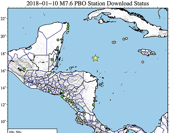
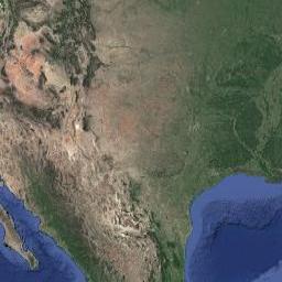
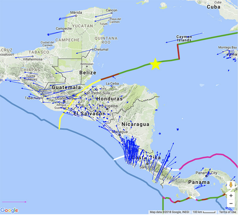
Figure 2. Map showing
continuous GPS/GNSS stations near the epicenter (yellow star) of the
January 10, 2018 M7.5 Earthquake 44km E of Great Swan Island, Honduras.
UNAVCO downloaded high-rate GPS/GNSS data from 17...Read more »
Written by Beth Bartel
22 January 2018
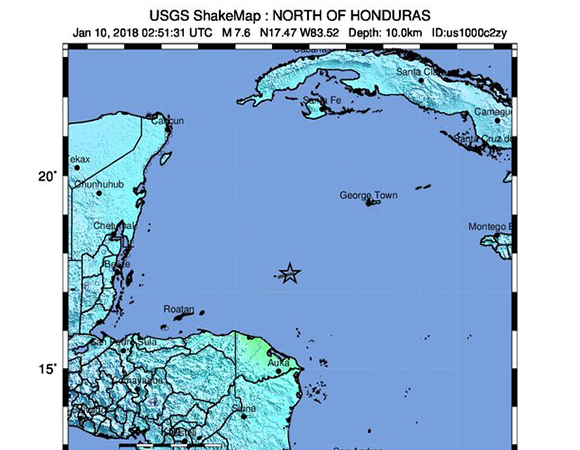
A Mw 7.5 earthquake occurred at 02:51:31 UTC on January 10, 2018 (20:51:31 January 9, 2018 local) 44km E of Great Swan Island, Honduras.
For more information, see the USGS Earthquake Hazards Program event page.
GPS Data
UNAVCO downloaded high-rate 1-sps (1 Hz) and 5-sps (5 Hz) GPS/GNSS data
from 18 stations and 1-sps (1 Hz) data only from an additional three
stations in response to the M7.5 earthquake 44km E of Great Swan Island,
Honduras, on 2017-01-10 (Figure 2). Stations downloaded include 14 COCONet stations and additional stations operated by OVSICORI,
within 1000 km of the earthquake's epicenter. Date were downloaded for a
±3-hour period around the event (7 hours total, from 23:00 - 05:59
UTC). These data are available from the UNAVCO high rate data page.
Note: Six of these stations stream data in real time: TGMX, UNPM,
CN23, CN30, CN12, and SSIA; to request access to these and other RT-GPS
stations operated by UNAVCO please send an email request to rtgps![]() unavco.org.
unavco.org.
As part of this response, UNAVCO and partners reestablished communications to several COCONet stations and are prepared to send a field engineer to COCONet station CN18 on Swan Island if the Honduran navy is unable to repair the station onsite.
Stations downloaded:
GCFS (COCONet)
LCSB (COCONet)
TGMX (COCONet) (real-time)
UNPM (COCONet) (real-time)
CN24 (COCONet)
CNC0 (COCONet)
CN23 (COCONet) (real-time)
CN30 (COCONet) (real-time)
CN21 (COCONet)
CNG2 (Telica)
MOM0 (Telica)
KIOS (Telica)
SCW2 (Telica)
ELMA (Telica)
MANA (COCONet)
CGUI (Telica)
CN12 (COCONet) (real-time)
SSIA (COCONet) (real-time)
ELVI (Costa Rica / OVSICORI)
CN25 (COCONet)
CN35 (COCONet)
Borehole Strainmeter Data
UNAVCO has produced a fully processed 1-sps borehole strainmeter (BSM)
dataset spanning the time period of this event, available from the PBO borehole strainmeter event response page.

View a larger map.
Last modified: Monday, 05-Feb-2018 19:02:51 UTC


2018