
Latest News
[November 13, 2016] Massive Earthquake in New Zealand.
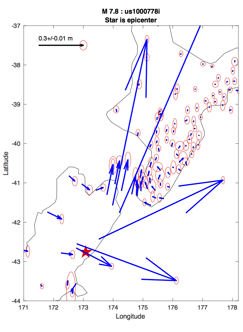
Earlier today,13 November 2016 at 11:02:57 UTC (23:02:57 their local time), a very powerful magnitude 7.8 earthquake rocked New Zealand, south of Wellington. The Nevada Geodetic Laboratory was able to access data from 118 continuously recording GPS stations on the island and estimate coseismic displacements within hours after the event using ultra-rapid orbits from the Jet Propulsion Laboratory. A figure showing a sample of the offsets is given below. The maximum displacements we found with GPS are at station CMBL near Clifford Bay, 1.3 meters east, 2.3 meters north, and 0.9 meters upward. A table of rapidly produced offsets is available [here].
While the displacements are very large, they continue to grow as we get more data hour by hour. This likely indicates that a slow but active afterslip on the fault plane, and/or possibly other physical relaxation mechanisms, continue to progress. These observations, along with a continuing sequence of aftershocks, indicates that the crust is still adjusting and evolving as part of this earthquake deformation event. Only GPS stations north of the rupture were strongly affected, which supports seismological evidence that the earthquake ruptured the crust north of the epicenter, where most of the ground shaking occured. The USGS event page for this event is [here].
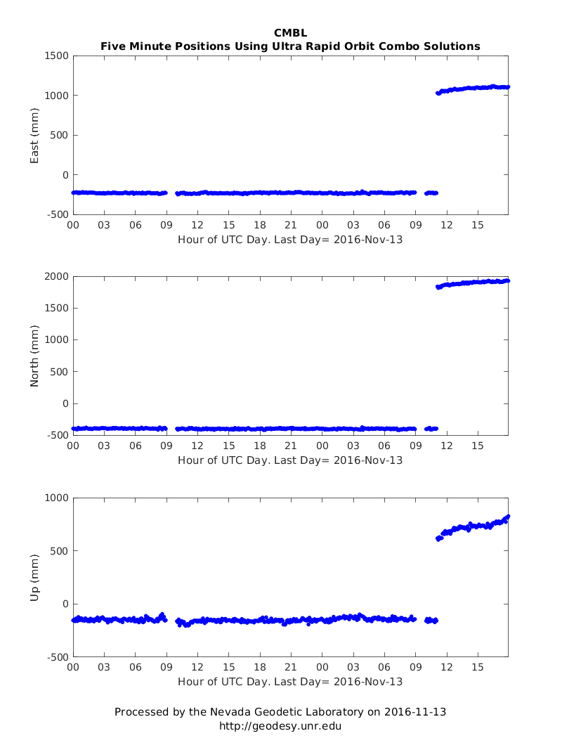
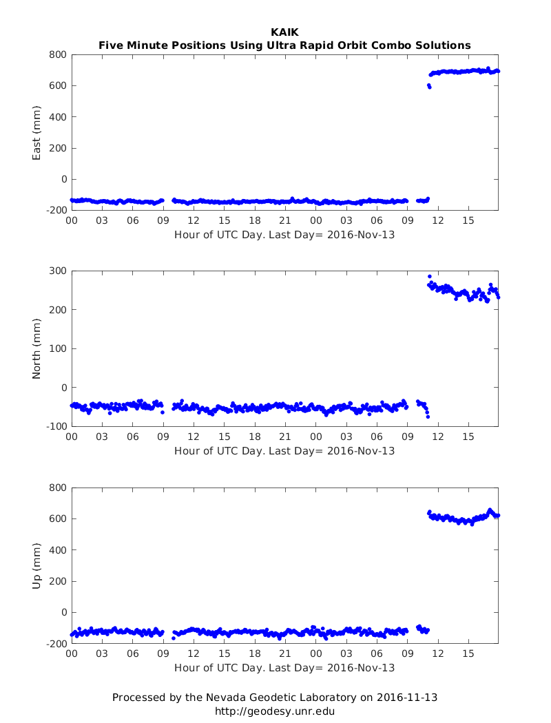
The two figures below show time series of 5 minute solutions for two stations with the largest offsets: KAIK and CMBL. Click to expand figures. Curvature of the time series after the offsets indicates ongoing relaxation.
|
|
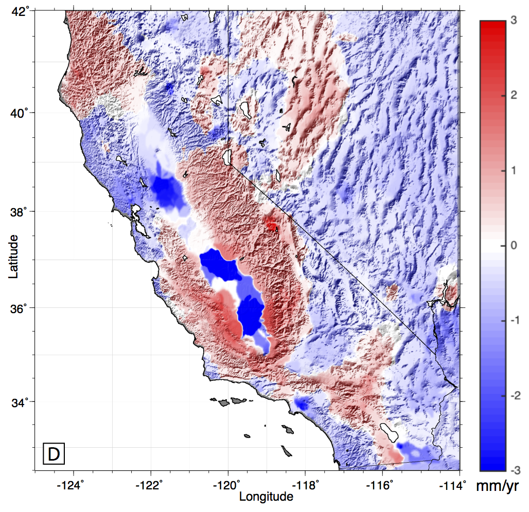
[October 12, 2016] New Paper: GPS Imaging of Sierra Nevada Uplift
Our new paper in JGR Solid Earth shows how our new analysis technique called "GPS Imaging" clarifies
the signal of vertical land motion in Nevada and California.
Using data from high precision GPS networks we resolve rates and patterns of uplift and subsidence in unprecedented detail.
The technique filters the data to enhance underlying signals of vertical movement of the deep solid Earth, which have significance for processes such as mountain growth, earthquake cycle deformation, mantle flow, hydrological mass loading and magmatic systems.
A draft of the Hammond et al., 2016 manuscript is now available online here:
JGR/PDF. Figure 6D from the article below shows the patterns of vertical motion superimposed on the topography. The colors represent vertical rate of the crust (in mm/yr), red up, blue down.
This article was given an Editors’ Highlight at JGR:
"This is the first paper to present such a comprehensive and precise vertical velocity field for a major section of the western United States (Lower 48). It highlights an exciting new method and presents an enormous data set along with its implications. There is a huge amount of data shown in the paper, and there are very interesting implications related to climate change and anthropogenic activity."
[August 29, 2016] M6.2 Earthquake in Central Italy
On August 24, 2016 an M6.2 earthquake hit central Italy near the towns of Norcia and Amatrice causing destruction and loss of ~300 lives. NGL has been routinely processing GPS data from many stations surrounding the effected area. Precise displacements of the solid Earth attributeable to this earthquake have been estimated using rapid orbits from JPL. The plot below shows the differenece in median station position 6 days before and up to 4 days after then event.
The largest offsets are seen at stations NRCI and LNSS which were nearest to the epicenter and moved to the southwest. The pattern of displacement is consistent with a normal faulting event with extension in a SW-NE direction. A table of the rapidly estimated offsets from the GPS time seres can be found here.
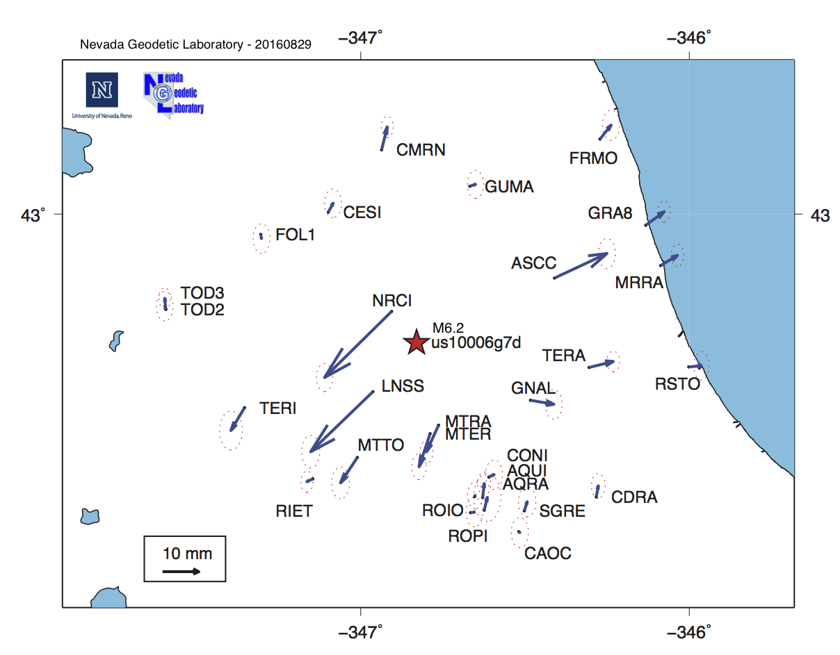
We obtained data from stations CAOC, CESI, CONI, GNAL, GUMA, LNSS, MTER, MTTO, ROPI, RSTO, SGRE from the RING network INGV Rome, Italy. Station AQUI from the Euref network. AQRA, CDRA, MRRA, MTRA are from S.I.T.T. Regione Abruzzo. Stations ASCC, CMRN, FOL1, FRMO, GRA8, NRCI, ROIO, TOD2, and TOD3 are from ItalPOS. Stations RIET, TERA, TERI are from the Rete Dinamica Nazionale.
[June 25, 2016] New Publication: Assessing the impact of vertical land motion on 20th century global mean sea level rise
Our new paper in The Journal of Geophysical Research - Oceans [Hamlington et al., 2016] documents the effect of vertical land motion (VLM) as seen throgh the global GPS network has on estimates of global mean sea level (GMSL) rise.
We applied our new GPS Imaging technique to assess the impact of VLM not associated with glacial isostaic adjustment (GIA) on GMSL. Non-GIA VLM results from plate tectonic interactions, matle flow and other processes that change surface elevation slowly over time. We use GPS Imaging to estimate VLM at over 1400 tide gauges, and compare it to estimates from GIA models.
We found that after correcting for GIA effects the tide gauges are on average experiencing positive uplift resulting in an net increase of the GMSL rise estimate by 0.24 +/- 0.08 mm per year. While this result is likely dependent on the subset of tide gauges used and other factors in the corrections, it suggests that non-GIA VLM plays a significant role in 20th century estimates of GMSL.
[June 21, 2016] New Publication: Pre- and post-seismic deformation related to the 2015, Mw7.8 Gorkha earthquake, Nepal
A new paper in Tectonophysics [Gualandi et al., 2016] details an analysis that separates the signals of hydrological loading and tectonics, and solves for the deep alfterslip that occurred following the Gorkha earthquake in Nepal. The results show that in the first 7 months after the event ~15% of the total deformation moment was afterslip, and about 77% of the afterslip moment was silent (not seen in the aftershocks). The paper is open access.[February 23, 2016] New Publication on Deformation and Faulting in the Central Walker Lane
We have published a new study that clarifies how normal faulting, strike slip faulting, and crustal block rotations work together to accommmodate tectonic deformation within the Central Walker Lane. The manuscript by Jayne Bormann et al. was published in the Earth and Planetary Science Letters, and is now available at the EPSL website.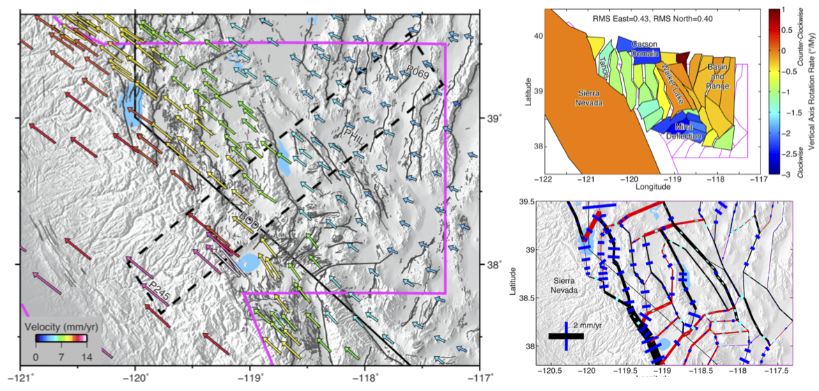
[February 18, 2016] New Publication and Velocity Fields Available!
We have published a new manuscript in the Journal of Geophysical Research on the MIDAS robust trend estimator. The paper by Blewitt, Kreemer, Hammond and Gazeaux documents the algorithm used to generate our new online velocity fields. These velocity fields are updated weekly and are available in our data products area (see right side of this page). The manuscript is open access, an unformatted .pdf is available HERE.[December 14, 2015] New Steps Database Product Available!
We have released an online database of potential step discontinuities in GPS time series. Information from IGS site logs is used to generate lists of equipment discontinuities. Earthquake data from the USGS is used to mark times of possible earthquake-related steps down to magnitude 5.0. Hyperlinked text tables are now at the bottom of every station page. A master list can be accessed HERE and a README file is HERE.[October, 2015] A wave of new papers published by the Nevada Geodetic Lab!
A new set of peer-reviewed publications with authors from NGL have recently become available:- Donnellan, A., L. Grant Ludwig, J.W. Parker, J. B. Rundle, J. Wang, M. Pierce, G. Blewitt, and S. Hensley, 2015, Potential for a large earthquake near Los Angeles inferred from the 2014 La Habra earthquake, Earth and Space Science, 2, doi:10.1002/2015EA000113.
(PDF)
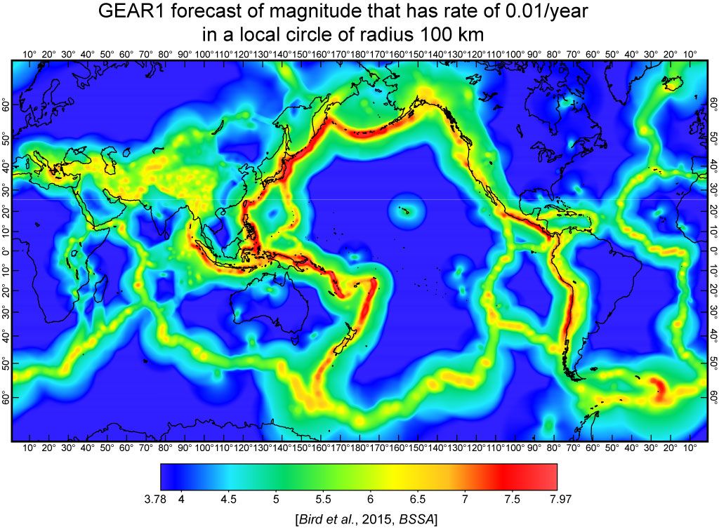
- Bird, P., D.D. Jackson, Y.Y. Kagan, C. Kreemer, and R.S. Stein, 2015. GEAR1: A Global Earthquake Activity Rate model constructed from geodetic strain rates and smoothed seismicity. Bulletin of the Seismological Society of America, 105, 2538-2554.
(PDF)
-
Keiding, M., C. Kreemer, C.D. Lindholm, S. Gradmann, O. Olesen and H.P. Kierulf, 2015. A comparison of strain rates and seismicity for Fennoscandia: depth dependency of deformation from glacial isostatic adjustment
Geophysical Journal International, 202, 1021-1028.
(PDF)
- Aster, R, M. Simons, R. Burgmann, N. Gomez, W.C. Hammond, S. Holbrook, E. Chaussard, L. Stearns, G. Egbert, J. Hole, T. Lay, S. McNutt, M. Oskin, B. Schmandt, D. Schmidt, J. Vidale, L. Wagner, P. Winberry, 2015, Future geophysical facilities required to address grand challenges in the Earth sciences, A Community report to the National Science Foundation.
(PDF)
- Blewitt, 2015, GPS and space-based geodetic methods, in Treatise in Geophysics, ed. G. Schubert, 307-333, Elsevier,doi:10.1016/B978-0-444-53802-4.00060-9.
(PDF)
- Blewitt, 2015, Terrestrial reference frame requirements for studies of geodynamics and climate change, International Association of Geodesy Symposia, 1-8, doi:10.1007/1345_2015_142.
(PDF)
- Bird, P., and C. Kreemer, 2015. Revised tectonic forecast of global shallow seismicity based on version 2.1 of the Global Strain Rate Map. Bulletin of the Seismological Society of America, 105, 152-166.
(PDF)
- Melgar, D., J. Geng, B.W. Crowell, J.S. Haase, W.C. Hammond, Y. Bock, R.M. Allen, 2015, Seismogeodesy of the 2014 Mw6.1 Napa, California, Earthquake: Rapid response and modeling of fast rupture on a dipping strike-slip fault, Journal of Geophysical Research - Solid Earth, 120, doi:10.1029/2015JB011921.
(PDF)
See, for example new results in Bird et al., 2015 . Here the GEAR1 forecast is for years 2014 and after, representing the magnitude forecast rate of 1% per year within a local circle of radius 100 km about each point.
[May 30, 2015] Geoff Blewitt elected President of IAG Commission 1: Reference Frames
The National Delegates of the International Association of Geodesy have voted Geoff to be President of Commission 1: Reference Frames. This organization defines and redefines longitude, latitude, and height that are of primary importance for much Earth science based research and applications, satelite navigation as well as for practical applications in geo-information. For more information on the commission see this link.Congratulations, Geoff!
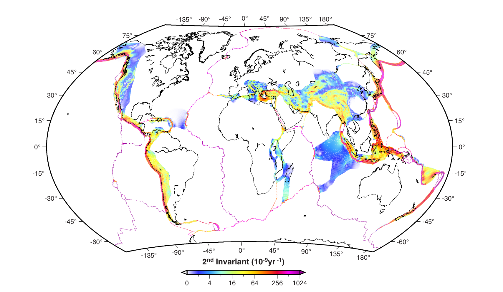
[November 18, 2014] New Global Strain Rate Model published in G-cubed.
|
| The cover of this month's issue of G-cubed shows this figure with contours of the second invariant of strain rate from the new Global Strain Rate Model (v. 2.1). The model is based on 22,415 horizontal geodetic velocities, 6705 of which were determined by the Nevada Geodetic Laboratory, the rest are from the literature. Non-linear color scale is saturated at high values. White areas were assumed to be rigid plates and no strain rates were calculated there. Instead, the rigid body rotation of these plates was imposed as boundary conditions when solving for plate boundary strain rates. |
|
Kreemer, C., G. Blewitt, E.C. Klein, 2014, A geodetic plate motion and Global Strain Rate Model, Geochemistry, Geophysics, Geosystems, 15, 3849-3889, doi:10.1002/2014GC005407. Links to: Online version Files of Interest |
[October 14, 2014] Geoff Blewitt Honored with Vening Meinesz Medal
|
Geoff has been awarded the Vening Meinesz Medal for 2015. The medal was established by the European Geosciences Union Division of Geodesy and
is the highest award offered in Europe that recognizes distinguished research in Geodesy.
The official announcement of the medal recipients was posted on October 13, 2014. A description of the medal and a list of past recipients is given here.
Congratulations Geoff!! |
|
[October 10, 2014] Bill Hammond Elected Secretary of AGU Geodesy Section
Bill will serve a two year term as Secretary. See The AGU Elections Page for this year's results.
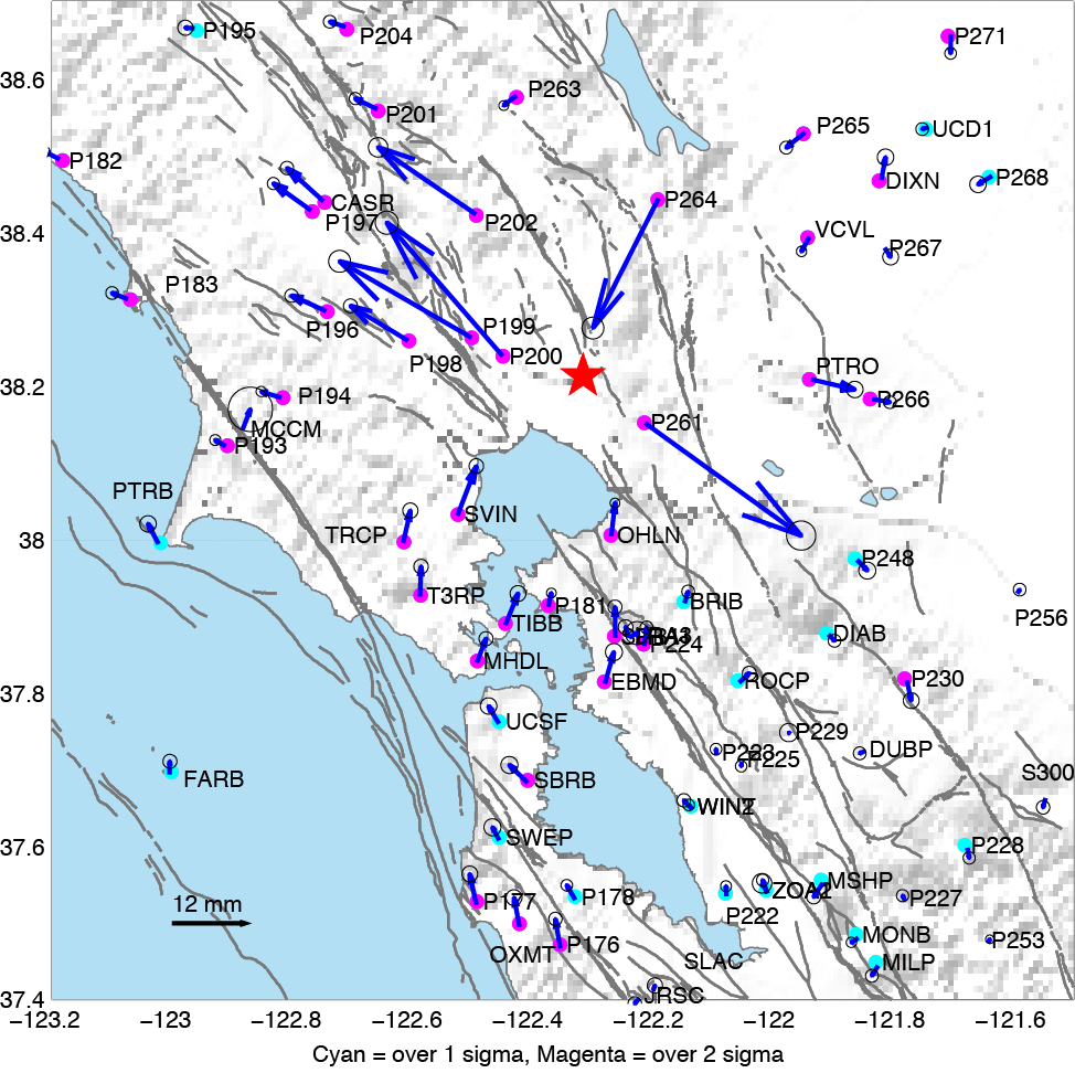
[August 25, 2014, 4pm PDT] M6.1 American Canyon earthquake seen in next day rapid GPS results
On August 24, 2014 at 3:20 am Pacific time a magnitude 6.1 earthquake struck the northern San Francisco Bay Area, near American Canyon and Napa California. By the next day, August 25 at 9:00 am we had estimated coseismic displacements, i.e. the amount the earth permanently shifted during the earthquake. Because continuously recording GPS stations are located on both sides of the fault these measurements can help to quickly identify which fault slipped, providing an independent corrobortion that it was likely the West Napa Fault Zone that activated during the earthquake.
See the NGL low-latency earthquake geodesy page for this event for more information.
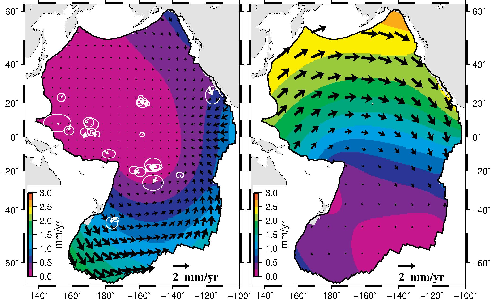
[August 15, 2014] Paper published by Corné Kreemer in Geology
Plate tectonics is one of the universal theories in Earth science that people have learned about in school. We challenge here a fundamental part of this theory: that the plates are rigid. Plate rigidity is plate tectonics' central approximation and gives the theory its rigor and predictive power. This study predicts and quantifies significant deformation within the young parts of the Pacific plate by assuming that the plate must contract horizontally due to the cooling of the plate as it moves away from its adjacent spreading centers. Thus one cannot assume that parts of the plate near the Pacific-Antarctic spreading center move rigidly with parts off the coast of California. Estimates of the relative motion between the Pacific and North America from sea-floor data in the south Pacific and Atlantic oceans differs by 5 mm/yr from direct observations, and this study can explain about half of this difference (the remainder may come from deformation of the oceanic parts of other plates). We find that the implied deformation in the Pacific plate has the same spatial distribution as the locations of earthquakes, which suggests that thermal contraction is (at least, partly) released seismically and improves our understanding of the cause of those enigmatic earthquakes.Link to the Kreemer and Gordon, 2014 article: here.
[May 14, 2014] Human-Induced Uplift of the Sierra Nevada in Nature
The Nevada Geodetic Laboratory has collaborated with scientists at Western Washington University, U.C. Berkeley and the University of Ottowa to publish a study on human-induced rise of the Sierra Nevada in Southern California. Uplift of 1-3 mm/yr can be attributed to elastic rebound following massive pumping of groundwater in the southern Great Valley. The unburdening flexes the lithosphere and helps explain observed trends and annual variations in seismicity on portions of the San Andreas Fault.The article (Amos et al., 2014) was published in the journal Nature and is also discussed in a News and Views piece Fertile Fields for Seismicity by Paul Lundgren of JPL.
The detailed analyses is part of a National Science Foundation (NSF) funded research project awarded to Blewitt and Hammond.
[April 21, 2014] Bill Hammond receives the 2013 Editor's Choice Citation for Excellence in Refereeing for his service to the Journal of Geophysical Research-Solid Earth.
Congrats, Bill! See page 5 of the Eos article.
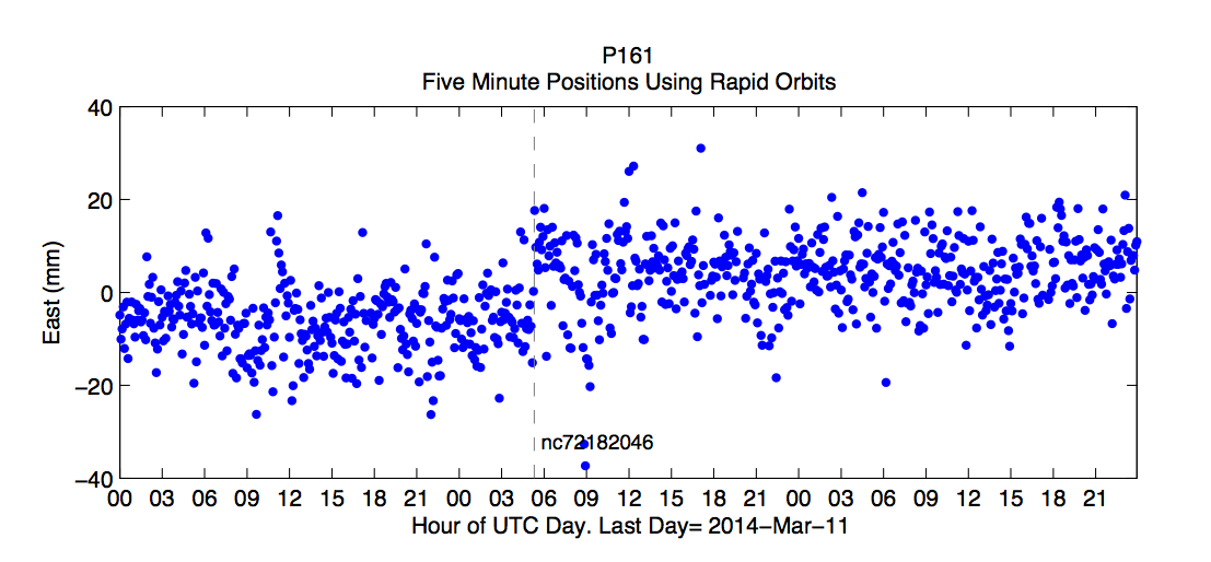
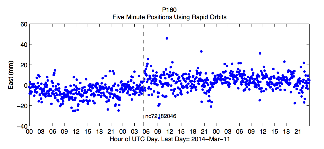
[March, 9 2014] The Ferndale, California offshore earthquake permanently displaced the coast by as much as ~15 mm to the east.
Though the event occurred nearly 80 km west of the coast, rapidly processed GPS solutions with 5 minutes sample interval show significant displacement at EarthScope Plate Boundary Observatory stations P159, P160, P161, P162. The plots below show changes in position of the GPS stations from this strike slip event. 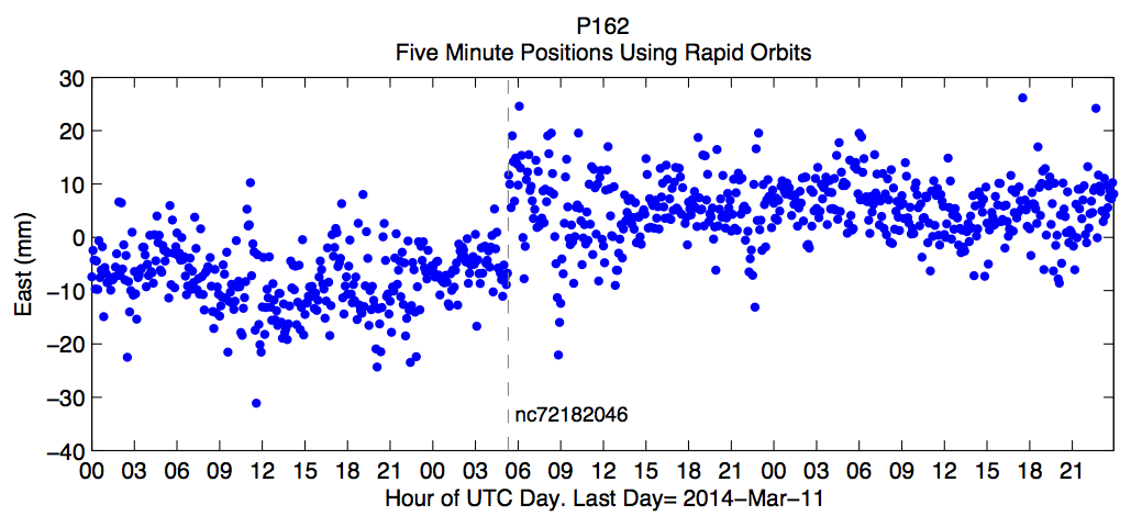 |
 |
 |
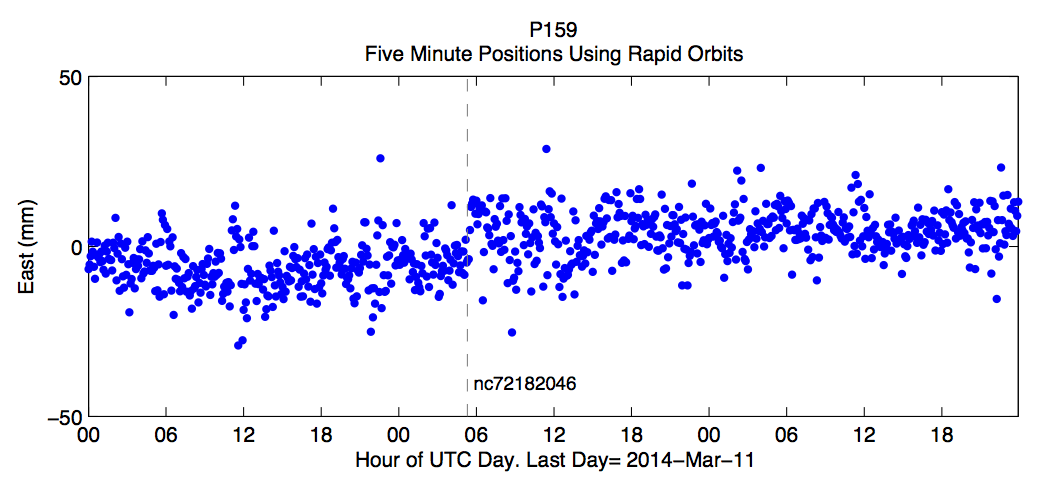 |
More information at the NGL station pages for: P159, P160, P161, P162.
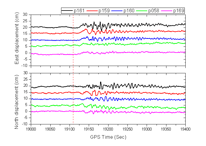
| 1 Hz displacements are shown in the analysis by Rongxin Fang (visiting scholar at NGL) for stations P058, P159, P160, P161, P169, using the PANDA software. In this analysis satelllite orbits and clocks are estimated in simulated real-time. Permanent offsets are visible within about 5 minutes of the event time (shown with red dashed line): |
 |
[December, 2013] We have developed a new North America plate fixed terrestrial reference frame for geodetic studies of crustal deformation.
The paper, published by Geoff Blewitt in the Journal of Geodynamics, can be obtained at here, or downloaded from our ftp server .[September 23, 2013] Geoff Blewitt gives seminar on space geodetic constraints on US west coast vertical land motion and sea level rise.
Click here to download the presentation (in .pdf format).
[May 5, 2013] Corné Kreemer nominated as EarthScope Series Speaker.
EarthScope speakers are selected based on their outstanding research accomplishments involving the NSF EarthScope facility as well as their abilities to engage a variety of audiences. Corné Kreemer will join the ranks of this prestigious group for the 2013-2014 series.
More information on the EarthScope Speaker Series.
[October 16, 2012] Geoffrey Blewitt elected AGU Geodesy Section President.
As President of the Geodesy Section, Professor Blewitt will serve a two year term as President Elect starting January 1, 2013, then 2 years as President. The American Geophysical Union has over 61,000 members from over 146 countries.
See Official AGU Election Results Here
[September 12, 2012] NGL's work featured as Science Snapshot at UNAVCO's Web page
NGL identified the need for the geodesy community to create a modeling framework that would integrate data archives, data analysis tools, and modeling software and provide access to these elements through a "Geodesy Community Workbench." A poster describing the Geodesy Community Workbench was presented at the recent UNAVCO Science Workshop, and this poster is featured as a Science Snapshot on UNAVCO's Web page. Read more ...
[July 20, 2012] NGL publishes map of geodetic strain rates in western U.S.
We just published an official NBMG map showing GPS velocities and an associated strain rate model for the Pacific-North American plate boundary, western U.S.
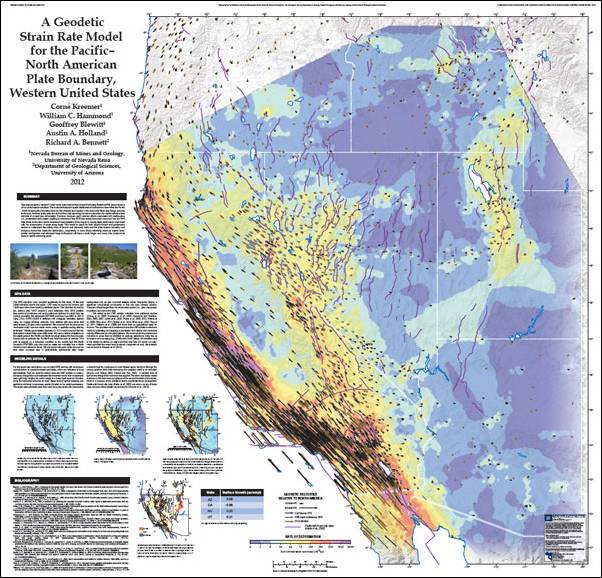
A free full-size PDF can be found here. It is 40Mb!!
[May 3, 2012] NGL publishes paper on Sierra Nevada uplift
The Sierra Nevada range in California and Nevada is actively uplifing at a rate of 1 to 2 mm/yr. Geodetic measurments based on over 10 years of GPS and InSAR data show that mountain growth can be observed directly, and help show that the Sierra Nevada topography is relatively young in geologic terms.The results are due to be published in the July, 2012 issue of Geology.
Access the full manuscript,
and read the UNR press release.
Also see stories at San Francisco Chronicle, OurAmazingPlanet.com, and Yahoo.[April 24, 2012] NASA uses NGL technology in GPS earthquake monitoring system
GPS technology developed and implemented at the University of Nevada, Reno will be the centerpiece of a major test this year by NASA to pinpoint the location and magnitude of strong earthquakes along the West Coast of the United States. The project was announced by NASA today.
Read the UNR press release and the NASA story.