
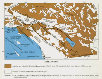
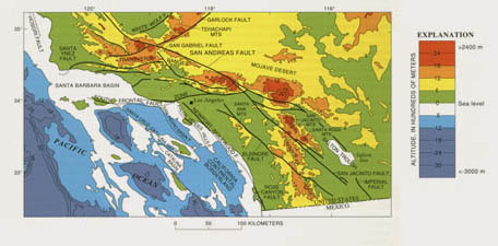
INTRODUCTION
|
|
Figure 4.1
|
Modern techniques of geologic dating and expanded research on earthquake hazards have greatly improved our knowledge of the San Andreas fault system. Much of this new knowledge has been gained since 1965, and that part which concerns crustal deformation during the past 2 m.y. is briefly summarized here.
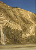
Figure 4.1 - Strata within a few hundred meters of the San Andreas fault are highly deformed. Here, folded and faulted beds of Pliocene age on the north side of the San Andreas fault are exposed in a road cut along California Highway 14 just south of Palmdale along the southern margin of the Mojave Desert. Photograph by R.E. Wallace, U.S. Geological Survey.
|
In emphasizing recent work, I cite only a few of those earlier investigators who first recorded the extent and timing of deformation in upper Cenozoic deposits. Their contributions deserve a more complete accounting, and in several works cited herein such credit is given, most thoroughly by Wahrhaftig and Birman (1965). Also especially important in understanding the framework of the fault system are the 1:250,000-scale, 1° by 2° sheets of the "Geologic Atlas of California" published by the California Division of Mines and Geology, the 1:750,000- scale "Geologic Map of California" (Jennings, 1977), and the 1:750,000-scale "Fault Map of California" (Jennings, 1975).
The Quaternary deformation processes - chiefly faulting, folding, and uplift-represent crustal changes that in many places continue today but at barely perceptible rates. The perspective of 2 m.y. of geologic time permits us to detect and measure these processes, and where historical deformation is evident-as shown by seismology, geodetic studies, or geologic investigations of recent earthquakes - the Quaternary record provides an independent check on the reliability of our observations and measurements. More importantly, we also use the Quaternary viewpoint to sketch the outlines of the currently active fault system, its intact crustal elements and major active faults, and how these faults propagate and change over time. From such evidence we can better understand the pre-Quaternary history of the system and build the predictive kinematic models needed for earthquake hazard assessment.
Evidence of Quaternary deformation comes chiefly from the observed displacement of strata or geomorphic features (fig. 4.1). Where this displacement can be dated or, at least, bracketed in time, the age of deformation can be established, and it's rate-generally an average-can be determined. In this report, most deformation rates are converted to units of centimeters per year, in part to facilitate comparison of different data sets but also because the dominant process, strike slip on major faults, is conveniently expressed in such units. Both the amount of displacement and the materials used to determine the age of displaced geologic markers require careful geologic analysis to ensure that field relations are unequivocal and correctly interpreted; the most reliable deformation rates depend on highly detailed analyses of local stratigraphy, which provide multiple measures of displacement over broad timespans, typically thousands to tens of thousands of years.
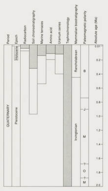
Deposits of Quaternary age can be dated by several methods, most of which ultimately depend on geochemical analyses that require highly sophisticated laboratory practices and expertise, as well as carefully chosen samples. The principal methods of dating Pleistocene and Holocene deposits within the San Andreas fault system (fig. 4.2) include radiocarbon, soil chronostratigraphy, correlation with standard sea-level stages (chiefly used for uplifted marine terraces), tephrochronology, and mammalian and invertebrate paleontology; supplementary techniques include paleomagnetism, uranium-series analysis, and amino-acid racemization. The underlying theory and limitations of these methods (for example, Pierce, 1986) are beyond the scope of this review. Each method, however, differs in resolving power, the time-span over which it is effective, and applicability to different rock types.
|
Figure 4.2 - Dating methods used in studies of the Quaternary deposits of the San Andreas fault system. Shading shows principal methods and timespans over which they have been most effectively used; open bars indicate potential range of the methods. Other available methods of Quaternary dating, some of which are not shown, either are little used or have produced few or no reported data on Quaternary deformation within the fault system. Paleomagnetic polarities: B, Brunhes Normal-Polarity Chron; J, Jaramillo Normal-Polarity Subchron; M, Matuyama Reversed-Polarity Chron; 0, Olduvai Normal-Polarity Subchron.
|
Difficulties in dating deformed Quaternary deposits are not the only deterrent to reconstructing the history of faulting. Large areas within the fault system are nearly devoid of Quaternary deposits; others are masked by landslide deposits, which conceal Quaternary folds and faults. Few published geologic maps differentiate between faults with Quaternary movement and those that have long been inactive, and for even the best known faults our knowledge of Quaternary faulting is still incomplete. Quaternary reverse and thrust faults, more difficult to identify and map than their strike-slip counterparts, are surely underrepresented on published geologic maps and in the literature.
Our knowledge of Quaternary deformation is thus incomplete and biased. We have learned much, and are rapidly learning more, about the Holocene and latest Pleistocene, but the view much beyond the past 100 ka is still poorly resolved. Despite the problems, the results of the past 2 decades of Quaternary research have brought new insights into the mechanics of the fault system and the promise of more discoveries yet to come.
NORTHERN SECTION OF THE SAN ANDREAS FAULT SYSTEM
SAN ANDREAS FAULT
|
|
Figure 4.3
|
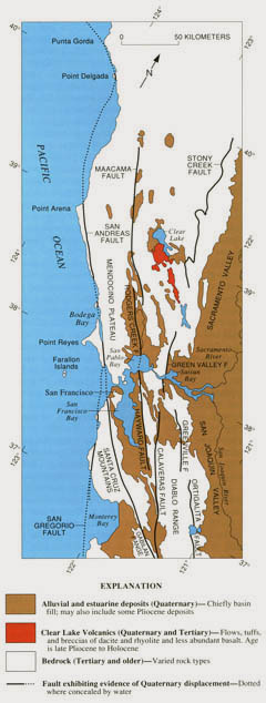
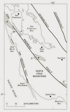
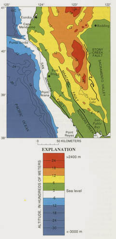
The northern section of the San Andreas fault system, as defined here, extends from Punta Gorda, 40 km southeast of the Mendocino triple junction, to the northern Gabilan Range (fig. 4.3). This belt of Quaternary- and earlier- faulting and folding, about 120 km wide by 500 km long, includes the San Andreas, at least four major related faults, and several smaller faults, 5 to 20 km long. All of these faults displace Quaternary deposits or landforms, and all are seismically active. From west to east, major faults within the system are the San Gregorio, San Andreas, Hayward (and its northern, right- stepping extensions, the Rodgers Creek-Healdsburg and Maacama faults), Calaveras (and its northern, right- stepping extensions, the Concord and Green Valley faults), and an ill-defined, possibly discontinuous fault zone along the eastern margin of the Coast Ranges that includes, from north to south, the Stony Creek, Greenville, and Ortigalita faults.
The offshore counterpart of the main San Andreas fault, which trends seaward and westward from Punta Gorda to the Mendocino triple junction, represents the latest segment of the northward-growing transform. This east-west-trending, offshore segment of the fault is located chiefly on seismic and bathymetric evidence; it follows along the north face of the Gorda Escarpment (along lat 40°23' N. and west of long 124°39' W.) and the south wall of Mattole Canyon (from the east end of the Gorda Escarpment southeast to lat 40°17' N., long 124°27' W.), but water depths of as much as 2,000 m, high submarine relief, and sea-floor deposits of young sediment (Silver, 1971; McCulloch and others, 1985) obscure details of its Quaternary history.
Figure 4.3 - Geologic sketch map of the northern Coast Ranges, central California, showing faults with Quaternary activity and basin deposits in northern section of the San Andreas fault system. Fault patterns are generalized, and only major faults are shown. Several Quaternary basins are fault bounded and aligned parallel to strike-slip faults, a relation most apparent along the Hayward-Rodgers Creek-Maacama fault trend.
|
From Punta Gorda southward to Point Arena the fault is almost entirely off shore; its location is known from sea-floor features, coastal geomorphology, and relations at Point Delgada, where it locally intersects the coastline. A line of coastal bluffs, 350 to 850 m high and sloping 33°-43°, trends N. 50° W. for 20 km northwest of Point Delgada. At the base of the bluffline, Lajoie and others (1982) measured Holocene uplift rates of about 0.5 cm/yr from dated molluscan fossils in beach ridges 30 m above present sea level. Seaward of the bluffs, the Spanish and Delgada Submarine Canyons head near the present coast, 2 to 3 km landward of the 100-m bathymetric contour, which approximately defines the late Wisconsin sea level. Shoreward of this contour, both canyons are linear, and neither they nor the intervening sea floor exhibits evidence of vertical or horizontal displacement. These relations are consistent with a near-shore San Andreas fault, located in or near the surf
zone and close to the base of the coastal bluffs. The unusually large component of vertical slip (0.5 cm/yr, northeast side up) for this segment of the fault may result from its more westerly trend than that of segments farther south, which exhibit almost pure strike slip; or, as suggested by Merritts and Bull (1989), it may result from the late Quaternary passage of the Mendocino triple junction along this part of the coast.
The fault intersects the coastline about 6 km northwest of Point Delgada, cuts across the point, and locally separates upper Pleistocene marine terrace gravel and younger alluvium (McLaughlin and others, 1983) along the coast from intensely deformed bedrock inland. Other locations have been suggested (Curry and Nason, 1967; Beutner and others, 1980; McLaughlin and others, 1983) for the fault here, but several lines of independent evidence support this trend, including fault slip during the 1906 earthquake (Lawson and others, 1908, p. 54-58), the alignment of scarps, sags, and saddles along the 1906 fault trend, bedrock faulting colinear with 1906 faulting (Brown and Wolfe, 1972), and continuity to the north and south with offshore and nearshore evidence of recent faulting.
From Point Delgada southward to Point Arena, a distance of 125 km, the fault is defined by aligned, chiefly west-facing scarps on the sea floor, the right-lateral deflection of Noyo Submarine Canyon, straight boundaries of irregular submarine topography, and a 2- to 5-km-wide zone of disturbed reflective layers evident in continuous seismic-reflection profiles (Curray and Nason, 1967). The shapes and dimensions of sea-floor features, as shown by seismic-reflection profiles and modern bathymetric maps, resemble fault-formed features on land and provide similar evidence for right-lateral strike slip. The offshore data, however, are insufficient to determine the amount of Quaternary displacement.
Onland segments of the fault between Point Arena and the Gabilan Range exhibit abundant geomorphic and geologic evidence of Quaternary displacement, some of which can be translated into slip rates. Trunk streams, systematically displaced from their headwaters by at least 10 km, record cumulative strike-slip faulting that must span much of Quaternary time.
|
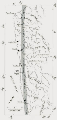
Figure 4.4 - Sketch map of part of northern California, showing coastal drainages south of Point Arena, systematically diverted by right-lateral slip on the San Andreas fault (dashed and shaded line). Possible offsets of 13.5 km are indicated for the Garcia River (A-A'), the Wheatfield Fork of the Gualala River (B-B'), and the South Fork of the Gualala River (C-C').
|
|
For example, the fault-deflected, northwest-trending courses of the Garcia and Gualala Rivers follow the fault zone for 50 km between Point Arena and Fort Ross; their present alignment (fig. 4.4) documents a long and complex history of channel extension and stream piracy. Three streams east of the fault-the Garcia River and the Wheatfield and South Forks of the Gualala River-exhibit similar offsets of about 13.5 km from possible former outlets to the sea west of the fault: the Garcia River from its present mouth near Point Arena, the Wheatfield Fork from the present mouth of the Gualala River near Gualala, and the South Fork from a low gap (110-m elevation) in the coastal ridge near the Sea Ranch. The average rate of post-Pliocene slip across the boundary between the North American and Pacific plates, derived from spreading rates at the mouth of the Gulf of California (DeMets and others, 1987, p. 912), is estimated at 5.1 cm/yr. In northern California, this slip is distributed chiefly on the
San Andreas and other active faults to the east. On the San Andreas fault at Point Arena, Prentice (1989) obtained a maximum slip rate of 2.6±0.3 cm/yr from a faulted stream channel 14C dated at 2,350 to 2,710 yr. Together with the assumed 13.5-km offsets, this rate implies that the postulated drainage diversions required about 519 ka. Other lines of evidence indicate much greater antiquity for this and nearby parallel strands of the fault.
Despite abundant evidence of Quaternary faulting along the northern section of the San Andreas fault, other examples of measurable fault displacement of dated upper Pliocene and Quaternary deposits are sparse. Much of the fault lies off shore, and most onshore segments cut older, highly deformed rocks of the Franciscan complex, from which the upper Cenozoic deposits have been eroded. Some reliable indicators of Quaternary slip, however, come from geologic and geomorphic relations observed from San Francisco southward.
On the San Francisco peninsula and farther south in the Santa Cruz Mountains, estimates of Quaternary slip on the San Andreas fault have been derived from offset biofacies and lithofacies relations. The fault offsets are in discontinuously exposed upper Cenozoic strata, which have been assigned by different investigators to the marine Merced, or Merced(?), Formation and the non-marine Santa Clara Formation. East of the San Andreas fault, both the Merced and Santa Clara Formations contain, in their upper parts, the 400-ka-old Rockland ash bed of Sarna-Wojcicki and others (1985), thus establishing at least a partial age equivalence of these two units.
The upper, Rockland ash-bearing part of the Merced Formation (Clifton and others, 1988) is fault bounded on the southwest and juxtaposed against a ridge of older rock for 11 km southeast of San Francisco (fig. 4.5). The minimum offset of 11 km from any western counterpart of the Merced outcrop belt and the 0.4- to 2.0-m.y. age of the faulted Merced strata require a minimum slip rate of 1.7±1.0 cm/yr for this section of the San Andreas fault.
|
Figure 4.5 - Fault-displaced geologic units on the San Francisco peninsula provide a basis for estimating the rate of strike slip on this section of the San Andreas fault- about 1.5 cm/yr for the Quaternary. Critical field relations include: A, outcrop belt of the marine Merced Formation, 2.0-0.4 Ma, truncated and faulted against older rocks for 11 km on the southwest; B-B', fault-displaced parts of a 3.0- to 2.O-Ma, late Pleistocene marine embayment (Addicott, 1969); C-C', 3.0- to 1.0-Ma nonmarine conglomerate of the Corte Madera facies of the Santa Clara Formation west of the fault and its source area east of the fault (Cummings, 1968); D, site where 1.2-ka Gate Holocene) slip rate of about 1.25 cm/yr (Hall, 1984) was measured. Quaternary slip has also occurred on the San Gregorio, Hayward, and Calaveras faults. Faults dotted where concealed by water.
|
A similar rate can be derived from the present distribution of upper Pleistocene marine deposits, which Addicott (1969) interpreted as the faulted remnants of a narrow marine embayment that once extended south-eastward across the San Andreas. The fault separation of 35 to 40 km (Addicott, 1969, fig. 2) and an assumed 2- to 3-m.y. age for the embayment yield a geologic slip rate of 1.6±0.4 cm/yr.
Additional evidence for Quaternary strike slip (Dibblee, 1966; Cummings, 1968) comes from the southern Santa Cruz Mountains south and west of San Jose. Distinctive reworked conglomerate clasts in the Corte Madera facies of the Santa Clara Formation west of the San Andreas fault are displaced 28 km from their source, an Upper Cretaceous pebble conglomerate lens on the east side of the fault. The age of the Corte Madera facies is poorly constrained, but Cummings (1968) assumed a probable age range of 1 to 3 m.y., which yields slip rates of about 1 to 3 cm/yr.
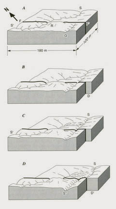
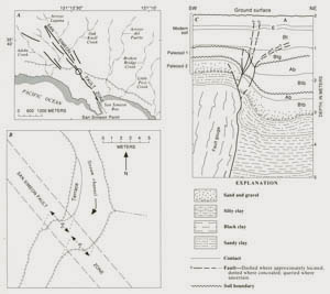
These slip rates carry uncertainties as great as ±1 cm/yr, but because they integrate slip over millions of years of geologic time, short-term changes in fault activity influence them only slightly. For comparison, a late Holocene slip rate is available from a site on the San Francisco peninsula, 11 km south of San Francisco. There, displaced and abandoned stream channels and relict alluvial deposits (fig. 4.6) were explored and described by Hall (1984; N. T. Hall, written commun., 1986). The alluvium, 14C dated at 1, 130±160 yr, accumulated along a northwest-flowing stream and behind a northwest-trending shutter ridge along the main fault trace. Alluviation ceased when fault slip, unusually high seasonal streamflow, or stream piracy caused the stream to abandon its fault-extended course and to carve a shorter, steeper, southwest-flowing channel across the fault and directly down the slope. This younger channel now exhibits 13.5 m of right-lateral offset
where it is crossed by the fault; about 2.7 m of this total offset can be attributed to fault displacement during the 1906 earthquake. Hall's (1984) analysis of this sequence of depositional, erosional, and faulting events yields a minimum slip rate for the past 1,200 yr of about 1.25 cm/yr.
|
Figure 4.6 - Interpretative block diagrams, based on relations described by Hall (1984), for a site on the San Andreas fault 11 km south of San Francisco. Rate of fault slip, about 1.25 cm/yr, is derived from observed 13.5-m stream offset, which postdates alluviation along original (precapture) streamcourse. A, Stream, flowing obliquely downslope from S to S', is partly diverted by ridge (R) where stream crosses the San Andreas fault (F-F'). Gully (G) heads southwest of fault, flowing toward observer. B, Displacements (D), caused by fault slip, offset stream and lengthen its channel; gully erodes headward across fault. C, Low gradient of stream channel causes alluviation upstream from fault, facilitating capture of its headwaters by gully and abandonment of streamcourse S-S'. Date of alluviation, 1,130 ± 160 yr B.P., from detrital charcoal dated by 14C methods. D, Renewed fault displacements (D') offset captured stream (S-S") by 13.5 m, an amount that includes 2.7 m of slip in
1906.
|
OTHER FAULTS
The rate of Quaternary strike slip along the northern section of the San Andreas fault south of San Francisco about 1. 5 cm/yr, is less than either the 5.1 cm/y; attributed to the plate boundary or the 2.5 to 3.5 cm/yr observed along more southerly segments of the fault. Much of this slip deficit can be accounted for by distributed slip on several other northern California faults that nearly parallel the main trace of the San Andreas.
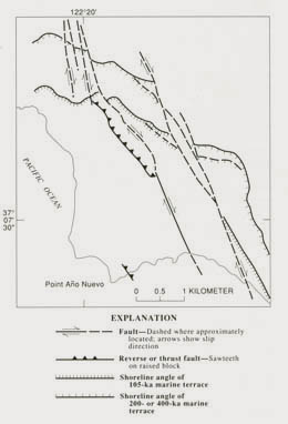
One of these faults, the San Gregorio, is the northern-most of a 400-km-Iong set of coastal faults lying south-west of the main trace of the San Andreas. The San Gregorio fault extends northward from Monterey Bay, joining the San Andreas about 20 km northwest of San Francisco, near Bolinas Bay. Where it cuts the coastline near Point Aiio Nuevo, the San Gregorio is a complex, 3- to 5-km-wide zone of near-vertical strike-slip and north-east-dipping reverse faults. Faults in this zone offset stream channels incised into marine and nonmarine strata that were deposited on a 105-ka-old wave-cut platform; the faults also offset the shoreline angle of this and at least one older wave-cut platform (fig. 4.7). Evidence from offset shoreline angles and faulted strata indicates a late Pleistocene, right-lateral slip rate of 0.6 to 1.1 cm/yr across the fault zone (Weber and Cotton 1981, p. 16, 72-75); Hamilton and others (1979), however, argued for rates of only 0.1 cm/yr in the same area.
|
Figure 4.7 - Sketch map of Point Año Nuevo area, northern California, showing fault-displaced shoreline angles in the San Gregorio fault zone. Broken segments of shoreline angles indicate possible alternative locations. This figure, simplified from Weber and Cotton (1981), shows the difficulty of accurately measuring displacement where faults intersect a relict shoreline at acute angles (see fig. 4.8A).
|
If the higher slip rate on the San Gregorio fault and the rates estimated for the San Andreas fault south of San Francisco are correct, Quaternary slip on the San Andreas north of its junction with the San Gregorio must be about 2.6 cm/yr-the sum of the rates on the two separate faults. This rate agrees closely with that previously cited for the San Andreas near Point Arena (Prentice, 1989).
Additional slip occurs along faults northeast of the San Andreas, as shown by geomorphic evidence, alignment of earthquake epicenters, and, on some faults, gradual fault creep amounting to as much as 1 cm/yr. Direct geologic evidence of Quaternary slip on such faults as the Hayward, Calaveras, and Green Valley is abundant, but the age and crossfault correlation of displaced stratigraphic markers are uncertain, and Quaternary slip rates are only weakly constrained. These rates, however, can be estimated from such other criteria as modern creep rates, geologic slip rates for displaced pre-Quaternary markers, and geomorphic expression relative to that along the San Andreas fault.
On such evidence, the most active fault trend, with Quaternary slip rates estimated to range from 0.5 to 1.0 cm/yr, is that defined by the southern section of the Calaveras fault and by the Hayward, Rodgers Creek-Healdsburg, and Maacama faults (fig. 4.3). Together, these faults extend for 375 km as a series of chiefly right-stepping breaks that exhibit abundant geomorphic evidence of recent movement. The seismically active Green Valley fault, locally as well defined as the Rodgers Creek and 27 km farther east, offsets cultural features that record right-lateral creep of 0.5 cm/yr between 1922 and 1974 (Frizzell and Brown, 1976).
The east boundary of the northern section of the San Andreas fault system follows a series of faults that trend north-northwest, exhibit recognizable components of right-lateral strike slip, and approximately separate the Coast Ranges from the Great Valley. This discontinuous and somewhat diffuse belt of faulting includes, from north to south, the Stony Creek, Greenville, and Ortigalita faults. No obvious surface faulting bridges the 100-km interval between the Stony Creek and Greenville faults, but major earthquakes in 1892 at Vacaville (lat 38°12.5' N., long 121°35' W) and Winters (lat 38°18.5' N., long 121°34' W.) may signify fault continuity at depth on this trend.
The historically aseismic Stony Creek fault follows and locally truncates a major detachment surface (the Coast Range thrust) that has been rotated to vertical or overturned. It now exhibits a steep east-facing scarp along the front of the Coast Ranges and separates a mountainous Franciscan terrane on the west from less deformed rocks on the east. Stream-terrace and fan deposits of Quaternary age east of the fault terminate at its scarp and are gently tilted and dissected by erosion. Sparse geologic evidence of renewed Quaternary faulting favors dominantly vertical slip, up to the west, but a right-lateral strike-slip component is indicated by asymmetric cusps and bays in the mapped trace of the fault and by nearby southeasterly-plunging folds that deform rocks at least as young as late Pliocene (Fox, 1983, p. 22).
System-boundary faults to the south exhibit both local seismic activity and evidence of Quaternary slip. The Greenville fault, here (fig. 4.3) combined with the Marsh Creek and Clayton faults, displaces Quaternary stream-terrace deposits and soils, as well as fold axes in middle to upper Tertiary marine deposits. Right-lateral slip rates on these faults range from 0.01 to 0.30 cm/yr, but most Quaternary rates are less than 0.1 cm/yr (Sweeney, 1982; Wright and others, 1982). These relatively low rates are consistent with weak geomorphic expression along this fault trend.
FOLDING, UPLIFT, AND VOLCANISM
Northwest- or east-west-trending folds deform much of the San Andreas fault system except for the relatively undeformed Sebastopol block (Fox, 1983) between the San Andreas fault and the fault trend defined by the Hayward, Rodgers Creek, and Maacama faults. The relative structural simplicity of this block is most evident between San Francisco Bay and about lat 39°30' N. (fig. 4.3), where flat-lying upper Miocene and Pliocene strata of the Wilson Grove (Fox, 1983) and Ohlson Ranch (Higgins, 1960) Formations extend across much of its surface. The erosional surface of this part of the block, the Mendocino Plateau (Lawson, 1894; Wahrhaftig and Birman, 1965, p. 323; Fox, 1983, p. 22-24), is a planar or gently warped upland with accordant ridge crests at elevations of 300 to 600 m. Fox (1983) contrasted the apparent stability of his Sebastopol block with a more typical, highly deformed region to the east, his Santa Rosa block.
In the Santa Rosa block and in other more easterly parts of the Coast Ranges, Quaternary folding and faulting have left uplifted or anticlinal ridges and downwarped or downfaulted basins. Some of the larger basins, now filled with locally derived sediment of Pliocene and Quaternary age, are the southern arm of the San Francisco Bay, Napa and Livermore Valleys (lat 38°20' N., long 122°0' W., and lat 37°40' N., long 121°50' W.), and the topographic basin surrounding Clear Lake (lat 39°01' N., long 122°30' W.). Smaller aligned or linear basins that follow northwest-trending faults or synclinal folds (fig. 4.3) clearly are structurally controlled. Rates of folding and uplift are best known for coastal regions. Marine terraces between San Francisco and Monterey Bay indicate general uplift of 120 to 180 m during the past 0.5 to 1 m.y. (Helley and others, 1979, p. 18)-an uplift rate of about 0.02 cm/yr. Local variation in uplift is shown by the deformed shoreline
angle and wave-cut platform of the youngest (82 ka) terrace (fig. 4.8); near Half Moon Bay, the wave-cut platform has been warped by northwest-trending folds into a surface that exhibits 60 m of structural relief over a distance of about 11 km (Lajoie, 1986, fig. 6.21). About 10 km west of Santa Cruz, this terrace is about 14 m above modern sea level (Bradley, 1957; Bradley and Griggs, 1976; Hanks and others, 1984, p. 5776-5777), indicating a local uplift rate of 0.04 cm/yr.
|
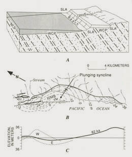
Figure 4.8 - Local variability in coastal uplift shown by deformed shoreline angle and wave-cut platform. A, Coastal geomorphic features used to measure Quaternary deformation. SLA, shoreline angle carved by marine erosion at present sea level; WCP, wave-cut platform; WCP' and SLA', elevated surface and shoreline angle, respectively, of an older wave-cut platform now mantled by marine terrace deposits and terrestrial sediment (light stippling). Normal seaward slope of wave-cut platform, exaggerated in diagram, is about 1°-2°. B, Folding and right-lateral faulting along the Seal Cove branch of the San Gregorio fault zone near Half Moon Bay (HMB), as shown by warped surface of an 82-ka wave-cut platform and deformation of its landward edge, the shoreline angle (heavy line). Structure contours (long dash on land, short dash off shore) on platform are derived from shallow boreholes and seismic-refraction data. Arrows on fault (dotted where concealed) indicate direction of
relative movement: U, upthrown side; D, downthrown side. Modified from Lajoie (1986). C, Platform profiles on fault plane (dotted lines: E, east; W, west), showing vertical separation across fault and deformation relative to shoreline angle (heavy line). Modified from Lajoie (1986).
|
Coastal uplift south of San Francisco contrasts with Quaternary crustal subsidence 25 to 30 km inland and east of the San Andreas fault (figs. 4.3, 4.5). Estuarine, stream-laid, and freshwater-swamp deposits of Quaternary age underlie the northwest-trending structural basin containing the San Francisco Bay and the Santa Clara Valley (lat 37°10' N., long 121°40' W.) to depths greater than 200 m below sea level. This prolonged Quaternary downwarping (Wahrhaftig and Birman, 1965) locally attained subsidence rates of 0.02 to 0.04 cm/yr (Atwater and others, 1977) during post-Sangamon time.
Despite such local variations in the amount and orientation of crustal processes, Quaternary uplift (fig. 4.9) prevails throughout the northern Coast Ranges. Regional uplift, at least partly of Quaternary age, is greatest and most evident east of the Hayward-Rodgers Creek-Maacama fault trend. Summit elevations north of Clear Lake exceed 1,500 m (Wahrhaftig and Birman, 1965, fig. 9), and those in the Diablo Range, south of the Livermore Valley, range from 600 to 1,200 m (Christensen, 1965, pl. 1). Both of these colinear uplands exhibit high relief, evidence of rapid downcutting, and cores of the emergent Franciscan complex flanked by outward-dipping strata of Pliocene and Quaternary age.
|
Figure 4.9 - Generalized surface on summit altitudes (Gipfelfiur) in the Coast Ranges north of San Francisco, showing major faults with Quaternary activity in the San Andreas fault system-that part of the map south of Cape Mendocino and west of the Sacramento Valley. Gipfelfiur approximately defines regions of Quaternary uplift and crustal blocks bounded by strike- and dip-slip faulting (dotted where concealed). Generalized from Wahrhaftig and Birman (1965).
|
Volcanic rocks of late Cenozoic age, widely distributed between the San Pablo Bay and Clear Lake, define a triangular. northwest-trending outcrop area, 120 km long by 35 km wide, with its most acute, north apex at Clear Lake. These rocks are assigned to two geographically separated extrusive sequences: the late Miocene and Pliocene Sonoma Volcanics to the south, and the younger, more areally restricted Clear Lake Volcanics (fig. 4.3) to the north. The Clear Lake Volcanics is almost wholly of Quaternary age. Flow surfaces, volcanoes, cinder cones, obsidian domes, and craters retain their original constructional form, and the Geysers Hot Springs area on the west side of the main volcanic field attests to continuing geothermal activity. Lava flows range in composition from olivine basalt to rhyolitic obsidian, and pyroclastic deposits are nearly as varied. The oldest well-dated rocks in the Clear Lake Volcanics Yield K-Ar ages near 2.1 Ma; the youngest-ash beds in lake sediment beneath
Clear Lake-Yield 14C ages of about 11 ka (Hearn and others, 1976; Sims and Rymer, 1975).
The sustained late Cenozoic volcanic episode recorded by the Sonoma and Clear Lake Volcanics is unique within the San Andreas fault system, although similar but less extensive Quaternary volcanism marks the northern end of the Gulf of California ridge-transform system in the Salton Trough (lat 33°19' N., long 115°50' W.).
CENTRAL SECTION OF THE SAN ANDREAS FAULT SYSTEM
SAN ANDREAS FAULT
From the Gabilan Range southward to the Transverse Ranges, the San Andreas fault itself dominates the fault system. Except for the San Gregorio- Hosgri set of coastal faults, branch faults are few and short, and exhibit less evidence of Quaternary activity than those farther north. This relatively simple pattern changes at the northern margin of the Transverse Ranges, where major folds and faults trend more east-westerly and incorporate large components of reverse and thrust motion. In this chapter, faults in the western Transverse Ranges and southern Coast Ranges are grouped together as components of the central section of the San Andreas fault system. This combination of two different structural and physiographic provinces stresses that the transition from compressional structures in the Transverse Ranges to strike-slip structures in the Coast Ranges is more gradual and less sharply defined than the physiographic boundary.
|
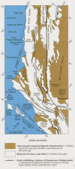
Figure 4.10 - Sketch map of southern Coast Ranges and western Transverse Ranges, southern California, showing faults with Quaternary activity and basin deposits in the central section of the San Andreas fault system. Fault patterns are generalized, and only major faults are shown.
|
|
This section of the fault system, 340 km long by 140 km wide, extends from the northern Gabilan Range to the southern Transverse Ranges, near lat 34° N. (fig. 4.10). Besides the San Andreas, faults with Quaternary slip include the Hosgri, San Simeon, and Rinconada in the north; the Big Pine, Ozena, South Cuyama, and Morales to the south and in the Coast Ranges; and the east-west-trending reverse and thrust faults in the Transverse Ranges. Several faults in the Transverse Ranges continue offshore into the Santa Barbara Basin.
The San Andreas fault trends S. 40° E. from the northern Gabilan Range to the Carrizo Plain; there, it bends eastward and ultimately attains as. 75° E. trend in the Transverse Ranges. North of the bend, it follows a series of nearly aligned stream valleys, which separate the Diablo Range and parts of the Temblor Range on the northeast from the Gabilan Range, Cholame Hills (lat 35°27' .N., long 120°18' W.), and Caliente Range (lat 35°02' N., long 119°46' W.) on the southwest (Brown, 1970; Vedder and Wallace, 1970). An actively creeping length of the fault, with historical slip rates as high as 3.4 cm/yr, extends 160 km southward from the northern Gabilan Range to the south end of the Diablo Range.
To the south, along the boundary between the Transverse Ranges and the Mojave Desert, the fault continues as a series of closely aligned echelon breaks, in a narrow (0.5 km wide) linear trench. This segment, which also displays abundant geomorphic evidence of Quaternary slip (Ross, 1969), is currently locked and seismically quiet.
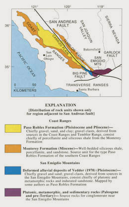
Hill and Dibblee (1953, p. 446), in proposing large sustained strike slip on the San Andreas fault, described fault-juxtaposed gravels of similar age but different lithologies in the area between the Temblor Range and the Transverse Ranges (fig. 4.11). Pebble gravel in the Paso Robles Formation, of Pleistocene and Pliocene age, consists chiefly of porcellanite and siliceous shale clasts derived from the Miocene Monterey Formation of the western Coast Ranges and the Temblor Range. These distinctive Paso Robles gravel beds are most extensive southwest of the San Andreas fault, but northeast of the fault they extend as a narrow band to about lat 35° N. For several kilometers near this latitude, they are faulted against Pleistocene gravel containing clasts of plutonic and metamorphic rock and indurated sandstone, derived from the San Emigdio Mountains to the south. According to Hill and Dibblee (1953, fig. 2), the depositional contact between the two gravel lithologies is displaced
about 16 km from its prefaulting location.
|
Figure 4.11 - Midway between Bakersfield and Santa Barbara, Calif., the San Andreas fault locally juxtaposes conglomerates of similar age but different lithologies. Porcellanite and siliceous shale clasts immediately northeast of the fault were derived chiefly from the folded and uplifted Monterey Formation in the southern Coast Ranges; plutonic, metamorphic, and sedimentary clasts across the fault to the southwest were derived from the San Emigdio Mountains of the northern Transverse Ranges. Total displacement and precise age of conglomerate units are unknown, but mapped offset of at least 16 km requires sustained Quaternary strike slip, as recognized by Hill and Dibblee (1953).
|
Farther north, between lat 35°30' and 35°45' N., Galehouse (1967, p. 974-976) described different clast compositions and heavy-mineral assemblages in Paso Robles strata on opposite sides of the fault. These differences are reasonably and consistently resolved if 40 km of right-lateral fault slip is removed, restoring the offset facies to their original positions.
These displaced stratigraphic relations imply Quaternary slip of 16 to 40 km, but the uncertain age of the faulted strata makes estimates of the slip rate unreliable. More accurate measurements of fault slip have been obtained at three localities north of the Transverse Ranges: two in the creeping segment and one in the more southerly, currently locked segment that produced the 1857 earthquake.
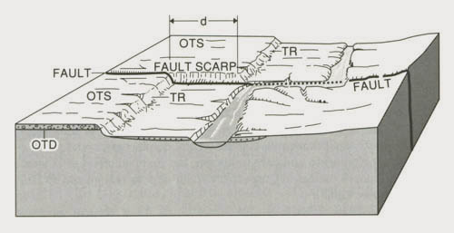
At the northernmost locality (lat 36°34.9' N., long 121°10.4' W.), along the San Benito River near the east boundary of the Gabilan Range, the fault displaces the risers of river terraces (fig. 4.12), exhibiting 64 m of right slip. Trenches on the terrace near the fault disclosed a fluvial scarp and a distinctive sand bed, both offset about 17.7 m by faulting during the past 790±144 14C yr (Perkins and others, 1989). The slip rate calculated from these data, about 2.2 cm/yr, agrees closely with creep rates currently observed along this section of the fault.
|
Figure 4.12 - Fault displacement (d) of stream-terrace risers (TR) postdates old terrace deposits (OTD), which underlie old terrace surface (OTS). Dating of terrace deposits gives a maximum age for displacement and thus a minimum slip rate for the fault (arrows indicate direction of relative movement; fault dotted where concealed by stream). The unrealistically simple relations shown in this sketch eliminate the effects of multiple terraces, changing rates of lateral erosion by the stream, and other processes that, under normal field exposures, make analysis much more difficult.
|
In Bitterwater Valley (lat 36°23.9' N., long 120°58. 9' W.), 27 km southeast of the San Benito River locality, fault-displaced buried channels in an alluvial fan of Quaternary age record a slip rate over the past 1 ka of about 2.8 cm/yr (Cotton and others, 1986), but the slip rate, as well as its distribution within the fault zone, has varied over time. The historical slip rate, 3.4 cm/yr, represents chiefly gradual fault creep and is based on offsets observed in fences built in 1908 and in channels that presumably date from about 1885. According to Cotton and others (1986), at least one episode of slower movement is evident, and, during the past 1 ka, slip across the 20-m-wide fault zone has followed different breaks.
Sieh and Jahns (1984) measured and dated late Quaternary displacement on the San Andreas fault at Wallace Creek (lat 35°16.3' N., long 119°49.7' W.), near the southwestern margin of the Temblor Range. ''Wallace Creek," an informal name (Sieh and Jahns, 1984, p. 896) for a previously unnamed drainage, does not appear on published U. S. Geological Survey topographic maps. At this locality, dated fan and channel deposits, stratigraphic and geomorphic relations, and fault offsets of both abandoned and existing stream channels document 128±1 m of strike-slip displacement (fig. 4.13). This record of cumulative fault slip began with incision of the existing channel of Wallace Creek sometime after 3,680±155 yr ago and ended with the nearly 10 m of fault slip that accompanied the 1857 earthquake. Because the 3,680-yr 14C age is measured relative to A.D. 1950, the appropriate timespan for the measured slip is 3,680-(1,950-1,857), or 3,587 yr. The minimum rate
is thus 128 m/3,587 yr, or 3.57±0.2 cm/yr; the maximum rate, based on the stratigraphy and geometry of the abandoned channel, is 3.53±0.2 cm/yr. When these maximum and minimum values are combined and adjusted to incorporate uncertainty in the state of strain at the beginning of the time interval, a preferred slip rate (Sieh and Jahns, 1984, p. 891) of 3.39±0.3 cm/yr is obtained. A similar but more complex analysis of 13,250-yr-old fan deposits displaced 475 m from their source gullies Yields a slip rate of 3.58±0.5 cm/yr (Sieh and Jahns, 1984, p. 891-892) for the past 13,250 yr. The close agreement of these rates suggests that the average rate of late Quaternary fault slip has been relative uniform at this locality.
|
Figure 4.13 - Slip on the San Andreas fault at Wallace Creek (lat 35°16.3' N., long 119°49.7' W.) has displaced dated alluvial deposits, as well as stream channels and other geomorphic features. Trenches excavated across and parallel to fault at this locality disclose details of stratigraphy, origin of stratigraphic units, and their age as determined from detrital charcoal. Displacements of different ages yield similar average slip rates of about 3.4 cm/yr. Original source drainages for older fan alluvium are near or southeast of right margin of figure. Simplified from Sieh and Jahns (1984, fig. 2).
|
Horizontal slip rates on the San Andreas fault are less well constrained in the western Transverse Ranges. Davis (1983, p. 368) and Rust (1982) independently estimated slip rates in the range 2-5 cm/yr for areas 70 km apart and on opposite sides of the junction of the Garlock fault with the San Andreas. These estimates involve substantial uncertainty in the amount and (or) timing of slip; they also apply to different parts of the Quaternary - no more than the past 400 ka for displaced gravel deposits in the San Emigdio Mountains (Davis, 1983), and no more than the past 2 ka for offset landslide deposits 32 km southeast of the Garlock-San Andreas fault junction (Rust, 1982). These rates, however, are broadly consistent with those measured to the north. Moreover, they indicate that much Quaternary strike slip in the western Transverse Ranges has followed the main trace of the San Andreas-a departure from pre-Quaternary history, when the San Gabriel fault to the southwest accommodated
much of the fault slip (Crowell, 1975).
OTHER FAULTS
Other faults with known or probable Quaternary slip in the central Coast Ranges include the Rinconada, Big Pine, Ozena, South Cuyama, Morales, and a coastal fault defined by its aligned but separately named segments: Hosgri, San Simeon, Sur (lat 36°10.8' N., long 121°32' W.), Monterey Bay (lat 36°40' N., long 122°06' W.), and San Gregorio. For most of these faults, the evidence of Quaternary activity is sparse, discontinuous along strike, and in places arguable. It includes weakly expressed scarps and drainage offsets, displaced deposits of late Pliocene and Quaternary age, and historical seismicity along some fault trends. The geologic and geophysical evidence for Quaternary activity is somewhat more convincing for the Hosgri fault and its northern, colinear counterparts than for faults farther inland.
The Hosgri and similarly aligned coastal faults trend north-northwesterly from near Point Conception (Steritz and others, 1986) to the latitude of Monterey Bay (Silver and Normark, 1978), where they continue northward as the San Gregorio fault. For most of its length, this coastal fault zone is a complex, multistrand break a few kilometers off shore; it is recognized and mapped from juxtaposed stratal units interpreted from seismic-reflection profiles and truncated magnetic anomalies. Locally, sea-floor scarps and displaced Holocene deposits, interpreted from the seismic-reflection profiles, confirm its Quaternary activity (Wagner, 1974; Leslie, 1981).
The San Simeon fault (fig. 4.14), which may be an onshore segment of the Hosgri (Leslie, 1981), is also a multistrand break; it cuts and displaces late Pleistocene marine terraces and Holocene dune sands near San Simeon Point (Weber, 1983). Although faulted shoreline-angle geometry and the correlation of wave-cut platforms across this fault are subject to some uncertainty, Weber (1983, p. 56-59) and Hanson and others (1987) suggested a horizontal right-slip component of about 0.5 cm/yr. Earthquake focal mechanisms along the San Simeon fault indicate a dip of 55° E. and nearly equal components of reverse and strike slip (Eaton, 1984). Right-oblique slip at a rate of about 0.5 cm/yr on the Hosgri fault is indicated by earthquake focal mechanisms, sea-floor scarps, the distribution of late Quaternary wave-cut platforms, and faulted seismic-reflection horizons of late Cenozoic age. Much of this evidence is documented from investigations near the Diablo Canyon Powerplant (Pacific Gas
and Electric Co., 1988), where it has been interpreted as pure strike slip.
|
Figure 4.14 - Sketch maps and columnar section of San Simeon area, central California, showing selected examples of Quaternary faulting on the San Simeon fault zone. A, Displacement of shoreline angle (hachured line) of 124-ka wave-cut platform; other younger and older marine terraces, mapped by Weber (1983), are not shown. B, 3-m offset (d1 and d2) of stream channel near circled locality in figure 4.14A. C, Faulted paleosols and possibly faulted modern soil in trench exposure near circled locality in figure 4. 14A; letters on right designate soil classifications. Quaternary strike-slip rate for this fault at the surface is about 0.5 cm/yr, but earthquake focal mechanisms (Eaton, 1984) indicate right-reverse slip at 6.6-km depth. From Pacific Gas and Electric Co. (unpub. data, 1986; see Pacific Gas and Electric Co., 1988).
|
In the western Transverse Ranges, faults with Quaternary displacement include some, like the San Andreas and San Gabriel, that exhibit chiefly strike slip and others, trending east-west or southwest, that exhibit reverse or oblique slip. The left-lateral Santa Ynez fault is an exception to the more general pattern of reverse and thrust faults. The reverse- and oblique-slip faults in the Transverse Ranges are complicated by splays, offsets, and changes in strike, but from north to south they define at least four major continuous, or nearly continuous, fault zones of different lengths: the Santa Ynez (130 km); the More Ranch-Mission Ridge-San Cayetano (110 km), from the coast near Santa Barbara, eastward; the Mission Hills-San Fernando-Sierra Madre (56 km), along the southwest side of the San Gabriel Mountains; and the South Frontal (250 km). Many of these faults exhibit evidence of Holocene movement, and the San Fernando fault produced the surface rupture and destructive
M= 6.6 earthquake of February 1971. Some of these faults, and others with east-westward trends, extend offshore into the Santa Barbara Channel (lat 34°09' N., long 119°33' W.), where they also cut Pleistocene or Holocene deposits (Clarke and others, 1985). Ziony and Yerkes (1985, p. 43-60) provided more detailed descriptions and maps of the late Quaternary faults in this and nearby areas; they also noted (p. 44) a profound increase in deformation rates in and near the Transverse Ranges during the past 750 ka. This pulse of orogenic activity- manifested by the growth of folds, uplift, and accelerated slip on reverse and thrust faults-coincides with middle Pleistocene and younger deformation observed to the south (Woodford and others, 1954, p. 77-78) in the Los Angeles Basin.
Maximum and minimum slip rates for many of the faults in the Transverse Ranges are deduced from offsets observed in drainages, fan surfaces, river terraces, and wave-cut platforms. Reported by numerous investigators (Clark and others, 1984), these rates of chiefly oblique slip cluster around a few tenths of a centimeter per year, but dip-slip components as great as 0.9 cm/yr are reported (Rockwell, 1988) for the San Cayetano fault. Observed slip rates may represent only a fraction of the total structural growth of the ranges because much of the late Quaternary deformation is by folding and uplift.
Although most Quaternary faulting south of the Gabilan Range is confined to structural blocks west and south of the San Andreas, two major faults, the Garlock and White Wolf, diverge northeastward from the San Andreas near the north boundary of the Transverse Ranges (fig. 4.10). Neither of these faults exhibits a clearly defined junction with the San Andreas, but together they bound the horstlike block of Sierran basement that makes up the Tehachapi Mountains. The White Wolf, a south-east-dipping reverse fault that was the source of the Kern County M = 7. 7 earthquake of July 1952, exhibits geomorphic evidence of recent slip at the range front but is concealed to the west beneath the southern San Joaquin Valley. The Garlock, devoid of major historical seismicity, exhibits clear evidence of left-lateral Quaternary slip (Clark, 1973) that increases eastward from 0.2 cm/yr at a point 55 km east of the San Andreas to 1.1 cm/yr at a point 75 km to the east
(Clark and others, 1984).
FOLDING AND UPLIFT
Typically, Quaternary folds are more intense and better defined in thick Tertiary marine sequences than near or above such basement blocks as the granitic and metamorphic complexes of the Santa Lucia, La Panza, and Gabilan Ranges or the Franciscan core of the Diablo Range. Thus, some of the best expressed Quaternary folds are in the western Transverse Ranges (Bailey and Jahns, 1954, p. 95-98), the west side of the San Joaquin Valley (Harding, 1976), the Santa Maria Basin (Woodring and Bramlette, 1950, p. 109-116), and the southeast flank of the Santa Lucia Range (Compton, 1966). Harding (1976) used subsurface geologic data from oil fields northeast of the San Andreas fault to demonstrate that folding has moved outward from the San Andreas over time - the more northeasterly folds along the west side of the San Joaquin Valley being the youngest.
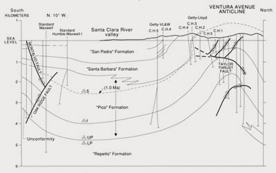
Rates of Quaternary folding in the westernmost Transverse Ranges exceed those elsewhere in the fault system. On the coast near Ventura (lat 34°07' N., long 119°18' W.), Pleistocene basin deposits more than 4 km thick have been intensely folded and faulted during the past 200 ka, attaining dips of 32°-45° in the southern limb of the Ventura Avenue anticline (fig. 4.15); uplift rates of about 1 cm/yr (Yeats, 1977; Lajoie and others, 1982) characterize the axis and southern limb of this fold. Uplift and folding elsewhere in the western Transverse Ranges may be slower but probably still exceeds deformation rates elsewhere in the fault system.
|
Figure 4.15 - Many drill holes penetrate well-dated Quaternary strata near the Ventura Avenue anticline. Besides the provincial microfaunal control shown here (3 small circles), Lajoie and others (1982b) employed a marine terrace (0.1-0.08 Ma) and 3 ash beds (0.6, 0.7, and 1.2 Ma) in the "San Pedro," "Santa Barbara," and "Pico" Formations of Yeats (1982) to estimate an average uplift rate of 1.25 cm/yr at the fold crest during the past 200 ka. Nearly all of this uplift is Quaternary in age; most is late Quaternary, as this highly generalized figure shows. Modified from Yeats (1982, fig. 7). Contacts and faults dashed where approximately located; arrows on faults indicate direction of relative movement. C.H., corehole; LP, lower Pliocene; UP, upper Pliocene; 1 and 5, provincial microfaunal markers.
|
Evidence for Quaternary uplift in this part of the San Andreas fault system is abundant and varied. High-standing ranges (Diablo, Santa Lucia, La Panza, and Transverse) emerge from a cover of their own eroded debris, represented by the Paso Robles Formation of the Coast Ranges, the Tulare Formation of the San Joaquin Valley and northern San Emigdio Mountains, and the Saugus Formation (and equivalent marine deposits) of the western Transverse Ranges. These upper Tertiary and Quaternary strata consist chiefly of alluvial debris, which has been deposited in fans, channels, and flood basins. Although the stratified deposits have been tilted, uplifted, and eroded (Bailey and Jahns, 1954; Christensen, 1965; Compton, 1966; Yeats, 1977; Davis, 1983), the map pattern of their remnants documents regional patterns of uplift.
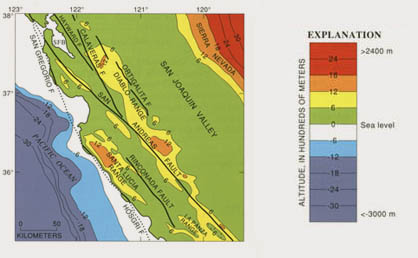
Christensen (1965) employed such evidence (fig. 4.16) to document uplift of 600 m in the Diablo, Santa Lucia, and La Panza Ranges and to establish general system-wide uplift, north of the Transverse Ranges, of about 300 m. This broad pattern of late Pliocene and Quaternary uplift is reversed chiefly in the Salinas and Santa Maria Valleys (lat 36°09' N., long 121°09' W., and lat 34°34' N., long 120°15' W.), Kettleman Plain (lat 35°55' N., long 120°05' W.), and southern San Joaquin Valley, where elongate deep (100-900 m) but local basins have formed at the edge of basement blocks.
|
Figure 4.16 - Generalized topographic map of central California between the San Francisco Bay (SFB) and the La Panza Range, showing major faults with Quaternary activity in the San Andreas fault system. Modified from Christensen (1965, pl. 1). Faults dotted where concealed by water; hachures on contours indicate area of closed low. Compare with figure 4.9.
|
Late Pliocene and Quaternary uplift of the northern San Emigdio Mountains totals about 1,800 m (Davis, 1983, p. 299-300), the present average height of a Pliocene erosion surface preserved on accordant ridge crests near the summit of the mountains. Relatively rapid uplift of the western Transverse Ranges was also accompanied by local downwarping of narrow basins-for example, the offshore Santa Barbara Basin and the Santa Clara River valley (fig. 4.15) east of Ventura.
Evidence that uplift is still continuing is found in raised, paired stream terraces and youthful drainage patterns in the Santa Lucia, Diablo, and western Transverse Ranges, in elevated Holocene marine terraces near Ventura (Lajoie and others, 1982), and in the radially segmented slopes of Holocene alluvial fans that record progressive episodes of deformation along the east front of the Diablo Range (Bull, 1964).
SOUTHERN SECTION OF THE SAN ANDREAS FAULT SYSTEM
SAN ANDREAS FAULT
South of the Transverse Ranges, the San Andreas fault system (fig. 4.17) extends to the latitude of the Salton Sea as a broad belt of northwest-trending strike-slip faults bounded on the northeast by the San Andreas and on the southwest by the offshore Santa Cruz-Catalina Ridge fault zone. Between the Salton Sea and the Gulf of California, the San Andreas fault system merges with a complex pattern of active ridge segments and transform faults that continues beneath the gulf for more than 1,200 km (see chap. 3). Alluvium of the Colorado River, lake deposits, and the waters of the gulf obscure the transition from the San Andreas pattern of deformation, dominated by northwest-trending strike-slip faults, to the ridge-transform pattern of the gulf, but current practice (see chap. 3; Crowell, 1981, p. 596-597) places the south boundary of the fault system near the latitude of the Salton Sea. Thus defined, the southern section of the San Andreas fault system is about 200 km long by 150 to
175 km wide.
|
Figure 4.17 - Sketch map of the eastern Transverse Ranges, Mojave Desert, and Salton Trough area, southern California, showing faults with Quaternary activity and basin deposits in the southern section of the San Andreas fault system. Fault patterns are generalized and only major faults are shown.
|
Late Quaternary faulting in this region follows several major breaks, of which the San Andreas is the most easterly and most active. The dominant role of the San Andreas fades south of Cajon Canyon (lat 34°18' N., long 117°28' W.), where the San Jacinto fault diverges from it, and farther south along the south front of the San Bernardino Mountains, where it merges into the Banning and Mission Creek reverse faults (lat 33°56' N., long 116°47' W., and lat 34°00' N., long 116°33' W.). Despite such complexities, continuity of Quaternary faulting on the main San Andreas can be traced at least as far south as the Salton Sea.
Large increments of Quaternary strike slip on the segment of the San Andreas fault along the San Gabriel Range front near Palmdale (lat 34°34' N., long 118°07' W.) were first recognized by systematic right-lateral stream offsets and by Pleistocene fan and terrace deposits displaced 2 to 8 km from their source regions across the fault (Wallace, 1949, p. 799-802; Noble, 1954, p. 46). Underlain by distinctive bodies of plutonic and metamorphic rocks, the ranges have contributed eroded debris to fans that spread across the range-front faults. Subsequent strike slip along these faults has displaced the distal parts of the fans laterally, separating them from their source rocks and opposing them against unlike rock types in nearby parts of the range front. Recent mapping (Barrows and others, 1985, p. 195-197) along the fault segment first described by Wallace (1949) and Noble (1954) constrains the slip rate there to values of 1.5 to 3.0 cm/yr (fig. 4.18).

|
Figure 4.18 - Estimated ranges in strike-slip rate on a 90-km segment of the main San Andreas fault north of Los Angeles. Stratigraphic nomenclature (from Barrows and others, 1985, fig. 4) identifies lithologically distinctive Quaternary deposits that have been horizontally displaced by fault slip on the San Andreas fault system.
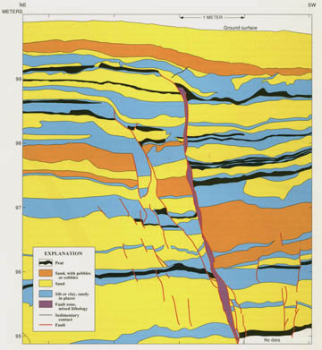
|
Most historical slip on the San Andreas fault has accompanied earthquakes of M≥6. A remarkable record of earlier earthquake-related faulting has been interpreted (Sieh, 1978, 1984; Sieh and others, 1989) from natural and manmade exposures across the fault at Pallett Creek, about 55 km northeast of Los Angeles, within the eastern part of the segment mapped by Barrows and others (1985). At Pallett Creek, Sieh described sand-blows and other liquefaction structures, buried scarps, and truncated fault strands in dated peat and alluvium that record (fig. 4.19) a history of 12 earthquakes during the past 1,700 yr. The latest 10 episodes of faulting establish an average recurrence interval of about 132 yr (Sieh, 1989) but show an irregular, clustered distribution over time for large earthquakes on this section of the fault.
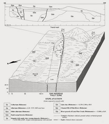
Slip rates along the San Andreas south of Pallett Creek are lower than those in the central section of the fault system; in part, this difference is accounted for by slip on the San Jacinto and other, more westerly faults. A site on the San Andreas fault in Cajon Canyon (lat 34°16.4' N., long 117°27.9' W.) about 100 km east of Los Angeles, establishes a consistent slip rate (Weldon and Sieh, 1985) for the late Pleistocene and Holocene time. Along Cajon and Lone Pine Creeks, the fault displaces terrace risers, buried and active stream channels, and landslides. The alluvial and swamp deposits have Yielded 14 14C ages. These dated fault displacements, in combination with a reconstructed fluvial history of the site, provide four independent measurements of fault slip that document an average slip rate for the past 14.4 ka of 2.5±0.4 cm/yr (fig. 4.20; Weldon and Sieh, 1985).
|
Figure 4.19 - San Andreas fault exposed in southeast wall of a trench at Pallett Creek, Calif., 55 km northeast of Los Angeles. Black strata are peat layers, datable by 14C methods, that show increasing amounts of vertical displacement with depth, owing to cumulative slip from repeated earthquakes. Vertical component of displacement visible here is a few percent of net displacement, which is chiefly strike slip, approximately normal to trench wall, with block on right moving toward observer. Uppermost, unfaulted deposits postdate 1857 earthquake; lowermost peat bed on southwest side of fault was deposited about A.D. 800. Modified from Sieh (1978).
|
|
Figure 4.20 - Near Cajon Canyon, 75 km east-northeast of Los Angeles, a displaced terrace riser (TR) between two Quaternary terrace levels (Qt2 and Qt3 of Lone Pine Creek, out of view in foreground) records slip on the San Andreas fault. Sketch, based on a planetable map (Weldon and Sieh, 1985, fig. 5), exaggerates relief by about 1.4 x; terrace risers actually slope no more than 25°. Relations used to establish Holocene history of faulting and a slip rate of about 2.5 cm/yr are derived from trench-wall exposures, here generalized from Weldon and Sieh (1985, fig. 12), and from geomorphic and stratigraphic evidence of stream piracy and other fluvial processes.
|
Harden and Matti (1989) reported slip rates that are less well constrained and possibly more variable for the San Andreas fault near Yucaipa, 45 km southeast of Cajon Canyon. There, displaced alluvial fans Yielded average slip rates of 1.4 to 2.5 cm/yr for the past 14 ka, 2.2 to 3.4 cm/yr for the past 30 ka, and 1.2 to 1.6 cm/yr for the past 65 or 90 ka. These rates imply an accelerating rate of latest Quaternary slip, but uncertainties in measurements of displacement and age permit rates that are constant or even diminishing over time.
Paired stream offsets along the southern branch of the San Andreas fault (lat 34°07.5' N., long 117°10.0' W.), between Yucaipa and Cajon Canyon and in San Bernardino (lat 34°06' N., long 117°17' W.), indicate a maximum slip rate of 2.5 cm/yr (Rasmussen, 1982, p. 112) based on estimated ages of 30 and 50 ka for faulted alluvial units. If, as Rasmussen suggested, these are minimum ages, the actual slip rate may be somewhat lower.
On the San Andreas fault and about 30 km north of the Salton Sea (lat 33°46.9' N., long 116°14.4' W.), Keller and others (1982) mapped a total offset of 700 m where two strands of the fault cut an alluvial fan. Soils developed on the fan surface indicate an age of 30 to 20 ka, bracketing the slip rate between 2.3 and 3.5 cm/yr. At a nearby locality, a rate of only a few tenths of a centimeter per year can be derived from displaced (1 m) sedimentary deposits associated with the latest highstands of former Lake Cahuilla, 700-300 yr B.P. (Sieh, 1981). These deposits, however, may be too young to record slip accompanying large earthquakes with recurrence times longer than 700 yr.
The San Andreas follows the east side of the Salton Sea southward for about 30 km; its trace is marked by offset Holocene features and at least two historical slip events (Sharp, 1982, p. 9). Farther south, in the Imperial Valley, evidence of surface faulting disappears, and a 40-km gap separates the south end of the San Andreas from the north end of the Imperial fault. This gap, nearby geothermal and volcanic activity, and the broad structural trough occupied by the Salton Sea and the Imperial Valley indicate a major change in deformation processes and a transition from the San Andreas fault system to the ridge-transform system of the Gulf of California.
OTHER FAULTS
The seismically active San Jacinto fault diverges from the San Andreas northwest of Cajon Canyon and follows a nearly straight course for 215 km, ending along the southwest side of the Salton Trough. On small-scale maps, it appears as a linear southward extension of the San Andreas segment bounding the San Gabriel Mountains-a simpler, more direct break than the arcuate, branching pattern of the nearly parallel San Andreas, 45 km to the northeast. Geomorphic and geologic evidence of Quaternary strike slip (Sharp, 1967, 1972, 1981) resembles that for the main San Andreas, but locally vertical motion, southwest side up, may account for as much as 10 percent of the net slip.
Sharp (1981) determined minimum slip rates for two active segments of the San Jacinto fault zone: the Clark fault near Anza Valley and the Coyote Creek fault, 80 km farther south. At the Anza Valley locality (lat 33°34' N., long 116°39' W.), the base of a distinctive gravel marker bed, displaced at least 5.7 km from its source terrane of schist, gneiss, and amphibolite, overlies 30 m of sediment which, in turn, overlie a rhyolite ash layer dated at 730 ka and correlated with the air-fall ash at the base of the Bishop Tuff. Geologic data require a slip rate of at least 0.8 crn/yr (Sharp, 1981, p. 1755-1757), and a higher rate, as high as 2.5 cm/yr, is possible (R. V. Sharp, in Clark and others, 1984). North of Anza, geologic relations during the past 30 ka yield evidence of average slip rates of 1.2 to 1. 7 cm/yr (Merifield and others, 1987) for this fault. The minimum Holocene slip rate for the past 6 ka on the Coyote Creek fault-derived from a 14C-dated, displaced channel
margin (lat 33°05.4' N., long 116°02.7' W.)-is 0.3 cm/yr, but a much higher rate is possible (R. V. Sharp, oral commun., 1986). Upper limits for the slip rate on the San Jacinto fault (Prentice and others, 1986; Rockwell and others, 1986; Merifield and others, 1987) thus range from 1.0 to 1. 7 crn/yr, in close agreement with Sharp's (1981) estimate of 0.8 to 1.2 crn/yr for the late Quaternary.
The Elsinore fault and its northern branches, the Whittier and Chino faults, lie about 35 km to the southwest of the San Jacinto fault. Seismic activity, occurring chiefly as small earthquakes, increases south- ward, but the strongest evidence for Quaternary faulting is along the north half of the fault, where Kennedy (1977) and Ziony and Yerkes (1985, table 5) reported examples of offset stratigraphy and landforms. South of lat 33°30' N., evidence of recent movement on the fault is sparse and widely spaced (Clark, 1975), although faulted Holocene fan deposits within 25 km of the United States-Mexican border indicate a strike-slip rate of about 0.4±0.1 cm/yr (Pinault and Rockwell, 1984).
South of its junction with the northeast-dipping Whittier reverse fault, the northern section of the Elsinore fault displays consistent evidence of oblique, dominantly horizontal slip. The vertical component is up to the southwest (Jahns, 1954, p. 45-46; Kennedy, 1977; Heath and others, 1982), as it is along the San Jacinto fault. For 100 km, the northern section of the Elsinore fault follows the northeast front of the Santa Ana and Elsinore Mountains, juxtaposing a thick Quaternary sedimentary fill on the northeast against pre-Tertiary crystalline and sedimentary rocks in the mountain blocks. South of Lake Elsinore (lat 33°39' N., long 117°21' W.), a facies boundary between sandstone and conglomerate, dated at about 700 ka by a layer of the Bishop Tuff, is offset 5 km (Kennedy, 1977, p. 5, 9), indicating a strike-slip rate of 0.7 cm/yr. North of Lake Elsinore, Millman and Rockwell (1985) reported at least 1.6 km of strike-slip offset since the middle Quaternary, equivalent
to a minimum slip rate of about 0.2 cm/yr. These observations and other geologic and geomorphic evidence along the fault suggest that the component of horizontal slip on the northern section of the Elsinore fault during the late Quaternary has been somewhat less than on the San Jacinto and probably does not exceed 0.7 cm/yr.
The Newport- Inglewood zone of deformation (Hill, 1971, p. 2958), 40 km southwest of the Elsinore fault, is a narrow (1-3 km wide) belt of echelon folds and left-stepping fault segments, characterized by oblique right slip, chiefly down to the west (Harding, 1973, fig. 5). This zone contains six major oil fields, within which subsurface structural relations in upper Cenozoic strata are well defined by drilling. Quaternary folding and faulting is expressed as an aligned series of anticlinal hills and by deformed and faulted upper Pliocene and Pleistocene deposits (Poland and others, 1959; Barrows, 1974). The overall structural trend is commonly mapped as the Newport-Inglewood fault (fig. 4.17), but individual segments are less continuous and less closely aligned than along other major strike-slip faults in the San Andreas system. Moreover, many anticlines along the zone retain their original ellipsoidal form even where they are cut by strike-slip faults
(Harding, 1973, figs. 2, 4, 7, 9-15).
The onshore, northern part of the N ewport- Inglewood fault zone extends 65 km from the Santa Monica Mountains (lat 34°03' N., long 118°24' W.) at the southern margin of the Transverse Ranges southeastward to Newport Beach. Farther southeast, the offshore part of the zone continues for about 70 km, defined by folding and faulting in Tertiary and Quaternary deposits (Clarke and others, 1985, p. 359) beneath the sea floor. Whether this zone of deformation is continuous with aligned but more distant offshore faults, such as the Rose Canyon fault near San Diego, is unresolved; if the zone is continuous, its overall length is at least 240 km.
Aligned swales and discontinuous eroded scarps, a few meters to as much as 80 m high, delineate individual fault segments; many of these scarps cut folded Pleistocene deposits. At the Inglewood and Long Beach oil fields on the northern, onshore part of the fault, folding and faulting are nearly as great in upper Pliocene strata as in older rocks (California Division of Oil and Gas, 1961, p. 577, 595), indicating that most of the deformation is Quaternary in age. Historical faulting is evident from the 1933 Long Beach earthquake (M=6.3) on an offshore segment of the zone, and from faulted artificial fill near Newport Beach (lat 33°22' N., long 117°33' W.) (Guptill and Heath, 1981). The horizontal slip in upper Pliocene strata, estimated from offset fold axes and from structure-contour maps of producing zones in faulted anticlines (Poland and others, 1959, p. 75; California Division of Oil and Gas, 1961), is about 1.5 km, equivalent to a slip rate of less
than 0.1 cm/yr. Vertical components of slip are about a fifth as large, and vertical separation of faulted basal Pleistocene deposits rarely exceeds 60 m (Yerkes and others, 1965, p. A48).
West of the Newport-Inglewood fault zone, northwest-trending faults that exhibit evidence of Quaternary slip (Clarke and others, 1985, fig. 185) include the Palos Verdes Hills fault, and the offshore San Pedro Basin and Santa Cruz-Catalina Ridge faults. The direction and amount of Quaternary displacement on these faults are ill defined, but they probably have strike-slip components smaller than those on the San Jacinto and San Andreas faults.
Many northwest-trending faults end near the 34th parallel against a major structural boundary that extends westward 250 km from the San Jacinto fault to Santa Cruz Island. This boundary separates the east-west-trending structures of the Transverse Ranges, Santa Barbara Basin, and northern Channel Islands (lat 34° N., long 120° W.) from northwest-trending structures to the south; it also separates higher land and sea floor to the north from lower to the south. A north-dipping zone of aligned or echelon faults (Yerkes and Lee, 1987; Ziony and Jones, 1988), here named the "South Frontal fault zone" (of the Transverse Ranges block), follows the structural boundary and includes, from west to east, the Santa Cruz Island, Anacapa, Santa Monica, Hollywood, Raymond, Sierra Madre, and Cucamonga faults. All of these faults are down to the south, all exhibit evidence of Quaternary activity, and many have been active during the Holocene. The San Fernando fault, an element of the Sierra
Madre trend, was the source of the damaging M=6. 6 San Fernando earthquake in 1971.
Slip rates on the South Frontal fault zone are probably lower than 0.5 cm/yr but are difficult to measure because most of the best exposed range-front faults consist of several branches. Typically, the youngest branches are farthest from the range front (Bull and others, 1979; McFadden and others, 1982) and cut tectonically derived fan deposits.
The vertical component of slip on the Cucamonga fault, about 0.3 cm/yr (Matti and others, 1982), is derived from a progressive increase in scarp heights-all close multiples of 2 m-in successively older alluvial-fan deposits. These deposits range in age from middle Pleistocene (approx. 700 ka) to late Holocene. The ages are based on stratigraphic relations, the maturity of soils developed on the fan surface (McFadden and others, 1982), and correlation of these soils with others (Bull and others, 1979) on ancient stream terraces in the San Gabriel Mountains.
FOLDING AND UPLIFT
The southern section of the San Andreas fault system resembles an inclined block (fig. 4.21), with its raised northeast edge along the San Andreas fault and its downtilted southwest half submerged beneath the Pacific Ocean. Near Los Angeles, topographic relief across this block exceeds 4,300 m: from Mount San Antonio (3,067 m) in the San Gabriel Mountains to the floor of the Catalina Basin (-1,300 m). This sloping and apparently tilted surface actually incorporates the results of strike-slip and reverse or thrust faulting, and regional uplift. Marine Quaternary deposits of the Los Angeles Basin, Ventura Basin, and adjoining offshore areas are locally as thick as 1,200 m (Yerkes, 1972), and lower Pleistocene beds, folded along northwestward trends, exhibit structural relief of more than 1 km in some parts of the Los Angeles Basin. Upper Pleistocene strata are deformed nearly as much, and evidence from drill holes and surface geologic mapping (Durham and Yerkes, 1964; Yerkes and
others, 1965; Yerkes, 1972; Shoellhamer and others, 1981) show that much of the folding is of late Quaternary age. Offshore Pliocene and Quaternary basins and folds also trend northwest. These basins, which border the coast as far south as San Diego (Howell and others, 1978), contain a thinner section of Upper Cenozoic strata than the Los Angeles Basin.
|
Figure 4.21 - Generalized topographic map of southern California, showing major faults with Quaternary activity in the San Andreas fault system. Faults dotted where concealed by water; hachures on contours indicate area of closed low. Compare with figures 4.9 and 4.16.
|
Some of the Quaternary folding, like that along the Newport-Inglewood fault zone, is probably directly related to strike slip on deeper wrench faults (Wilcox and others, 1973). Other, more westerly striking folds may reflect a compressional component of deformation similar to that shown by folds in the central and southern Coast Ranges. Fold patterns in the Los Angeles Basin are complicated by unknown amounts of differential compaction over a faulted and folded basement surface. This surface, nearly 10,000 m deep at the center of the basin (Yerkes and others, 1965, fig. 2), underlies a nearly complete section of marine Neogene strata, of which the near-surface Quaternary deposits make up a small part. The basin fill thus records almost continuous subsidence and marine deposition from Miocene time to the present.
Northeast of these late Cenozoic coastal basins, crystalline basement rocks either crop out or lie within a few hundred meters of the surface. Neogene subsidence of the coastal marine basins contrasts sharply with sustained and evidently rapid uplift, accompanied by thrust faulting, of the mountainous region to the east and northeast. The north-dipping San Fernando fault provided an example of such range-front tectonics in February 1971. Failure on this fault caused an M=6.6 earthquake, opened a 15-km-Iong zone of surface thrusting, and elevated the land north of the fault by as much as 2 m. Similarly, major Quaternary upwarping and faulting have helped shape the San Gabriel and San Jacinto Mountains; the San Bernardino Mountains (just beyond the boundary of the fault system as defined here) also display evidence of Quaternary uplift and thrust faulting and have apparently deformed with the other ranges.
Geologically recent uplift and tilting of the mountain ranges is indicated by extensive summit areas above 2,000 m, steep southwesterly-flowing streams in narrow V-shaped canyons, extensive alluvial fans and fan complexes at the northeast and southwest range fronts, and incompletely dissected Quaternary surfaces at elevations near 2,000 m. The dissected upland surfaces, most evident in the San Bernardino (Dibblee, 1975) and San Gabriel Mountains, appear as accordant ridge crests and as remnants of originally extensive uplands, some of which are underlain by Quaternary fan deposits and alluvium.
Other geologic evidence also implies rapid late Pleistocene and Holocene uplift. The Blackhawk and Silver Reef debris-avalanche deposits at the north edge of the San Bernardino Mountains record high-velocity (31 m/s), voluminous (0.28x 10⁹ m3 ) debris flows (Woodford and Harriss, 1928; Shreve, 1968), which surged northward from the range front as recently as 17.4 ka (Stout, 1975, 1977), leaving relict lobes of slide debris on the desert floor 10 km from the slide source. Smaller and slower debris flows and rock slides still occur from time to time in both the San Gabriel and San Bernardino Mountains.
Rates of late Quaternary uplift can be estimated for parts of the southern and central San Gabriel Mountains: near the mouth of Little Tujunga Canyon (lat 34°17' N., long 118°22' W.) (Menges and others, 1979), on the North Fork of the San Gabriel River (lat 34°09' N., long 117°31' W.) (McFadden and others, 1982), and across the Cucamonga fault (lat 34°10' N., long 117°31' W.) (Matti and others, 1982). Strath and fill terraces at the first two localities have been dated by physiographic position, 14C methods, and soil maturity; they range in age from middle Pleistocene to late Holocene (approx 1,000-700 ka). Terrace elevations above modern stream channels reflect both climatic and tectonic influences, but Bull and others (1979) and Menges and others (1979) separated these effects to obtain uplift rates of about 0.3 cm/yr for the Holocene and about 0.03 cm/yr for the late Pleistocene. Interpretation (Matti and others, 1982) of the displacement
history across strands of the Cucamonga fault, as discussed above, also results in an uplift rate of about 0.3 cm/yr for the latest Pleistocene and Holocene at the south front of the range. Together, these consistent estimates of uplift rate sample a 78-km segment of the San Gabriel front. Regional uplift rates to the north and northwest and within the main body of the Transverse Ranges are probably somewhat higher; rates for the western Transverse Ranges, as discussed in the section above entitled "Central Section of the San Andreas Fault System," are locally as high as 1 cm/yr near Ventura.
Elevated wave-cut platforms and marine-terrace deposits document Quaternary uplift of the southern California coast from the Transverse Ranges southward to San Diego. Mappable, well-dated (450-85 ka) marine terraces, which correlate with major worldwide high-stands of the sea, show nearly uniform coastal uplift at rates that range from about 0.01 to 0.05 cm/yr (Lajoie and others, 1979).
Similar uplift rates (approx 0.02 cm/yr) can be interpreted from the elevations and estimated ages of Quaternary erosional surfaces on the Perris structural block, which lies between the Elsinore and San Jacinto faults. Late Quaternary drainage systems on the Paloma erosional surface are presumed to be superimposed from the Gavilan-Lakeview surface (Woodford and others, 1971), which is nearly 200 m higher and an estimated 1 Ma older than the Paloma surface. Persistent uplift of the Perris block must be geologically recent because a late Miocene erosional surface, overlain by basalt dated at 8.3±0.5 Ma (J.W. Hawkins, in Woodford and others, 1971), is at an altitude intermediate between the two younger surfaces. The nearly horizontal remnants of the late Miocene erosional surface and the relatively undeformed detrital and eruptive strata of Neogene age attest to long-term vertical stability of the Perris structural block.
Together, the Quaternary geomorphic and geologic evidence south of the Transverse Ranges implies system-wide Pleistocene and Holocene uplift, but at higher rates toward the northeast than on the Perris and coastal blocks.
SUMMARY
Right-lateral strike slip on fewer than 10 major faults dominates the Quaternary record of deformation within the San Andreas fault system. Of these faults, the San Andreas is the longest and most active, but the fault system includes other structural elements, such as shorter or discontinuous strike-slip faults, reverse and thrust faults, regional fold systems, minor folds genetically related to strike slip along wrench faults, and tilted, uplifted, or depressed crustal blocks. All of these structures result from relative, predominantly horizontal motion at the boundary separating the Pacific and North American plates.
Though chiefly strike slip, the detailed pattern of Quaternary deformation differs from place to place within the fault system. Although the ultimate causes of these different structural patterns are ill defined and the subjects of continuing research, some geologic controls are evident: (1) the lithology and structure of basement rocks (see chap. 3), (2) the thickness of upper Mesozoic and Cenozoic strata overlying geologic basement, (3) the geometric orientation of major strike-slip faults, especially the San Andreas, and (4) the slip rates along structures controlling deformation.
Plutonic basement includes the granitic and associated metamorphic rocks of the Salinian block west of the San Andreas fault in the central Coast Ranges, similar rocks of the southern California batholith in the Peninsular Ranges, and a more complex suite of metamorphic and crystalline rocks in the central and eastern Transverse Ranges. Elsewhere in the fault system, the dominant basement-rock unit is the intensely sheared and broken Franciscan complex, which locally contains ophiolite bodies and remobilized, cold intrusive masses of serpentinite. The simplest patterns of Quaternary deformation are within regions of exposed or near-surface plutonic basement, where block-bounding strike-slip faults and block uplift or tilting prevail. Deformation is greater and more complex in regions of exposed or near-surface Franciscan basement, where broad anticlinoria, local basins, and distributed shearing are more evident. It is most intense and complex where basement rocks are covered by a
kilometer or more of stratified upper Mesozoic or Cenozoic rocks.
Control of Quaternary deformation processes by fault geometry, or the interdependence of process and geometry, is best shown at the Big Bend in the San Andreas fault near the north boundary of the Transverse Ranges. There, west-north west-trending folds and northwest-trending strike-slip faults of the northern and central sections of the fault system abut against a compressional domain characterized by east-west-trending folds, active thrust and reverse faults, and accelerated rates of vertical uplift. On much smaller scales, similar changes in structural trend and pattern appear at other changes in strike of the San Andreas or major branch faults.
The effect of different slip rates is demonstrated by the contrast in structural style along the San Andreas fault in central California and along the Newport-lnglewood fault zone in southern California. At a slip rate of 3.5 cm/yr, the San Andreas has displaced middle Pleistocene (1 Ma) outcrop belts and major structures by about 35 km, effectively creating-on opposite sides of the fault-two independent structural domains, each of which responds differently to its new structural setting. In the same period of time, the much lower slip rates on the Newport-Inglewood fault zone have separated Quaternary structures by less than 500 m, leaving the initial structural patterns at least partly intact and connected.
Our current knowledge of Quaternary deformation within the San Andreas fault system can be expressed in terms of estimated rates for deformation processes (fig. 4.22), even though reliable quantitative measurements of slip, folding, and uplift are few. Other lines of evidence from geologic mapping and geophysical investigations permit reasonable inferences regarding regional rates of deformation and the history of the fault system. Although some of these interpretations may change as new data are acquired, several major characteristics of the fault system and its Quaternary history are documented by the available evidence:
1. Quaternary tectonism within the San Andreas fault system has deformed an area of 160,000 km2 , extending from Punta Gorda to the Salton Sea, a system length of about 1,100 km, and from the Great Valley and the Mojave Desert to fault zones off shore in the Pacific Ocean, an average system width of about 145 km.
2. Throughout the fault system, the rate of right-lateral strike slip on northwesterly-trending faults typically exceeds the geologically determined rates for other deformation processes by an order of magnitude. Despite some important exceptions, horizontal slip approximately parallel to the plate boundary dominates the Quaternary history of the fault system.
3. In the central section of the fault system, between lat 35°45' and 36°30' N., most of this slip has followed the main San Andreas fault; slip rates on this section of the fault are the highest observed to date within the system, averaging about 3.5 cm/yr.
4. Strike slip is distributed more broadly in both the northern and southern sections of the fault system, where the main San Andreas splits into several active branches; slip rates on some of these branches may equal or exceed the rate on nearby parts of the main fault.
5. Observed rates of Quaternary faulting, summed across the fault system, are insufficient to account for all of the relative movement (5.1 cm/yr) attributed to the Pacific-North American plate boundary, but neither the magnitude of the difference nor its cause is well constrained.
6. East-westerly- to northwesterly-trending reverse and thrust faults occur near many strike-slip faults and elsewhere in the system; they are longer, more active, and best defined in and near the Transverse Ranges (between lat 33°45' and 35°00' N.), where they accompany rapid Quaternary uplift and intense folding on east-west-trending axes.
7. Major west-northwest-trending fold belts deform Quaternary and older strata overlying deeply buried (1-5 km deep) basement rocks; most regional fold belts strike obliquely to strike-slip faults and are consistent with wrench-fault structural patterns, but the age and intensity of folding differ from place to place.
8. Several fault-bounded basement blocks are internally little deformed: the Sebastopol block in northern California (Franciscan basement between the San Andreas and Rodgers Creek faults), the Salinian block in central California (granitic basement between the Rinconada and San Andreas faults), and the Perris block in southern California (granitic basement between the Elsinore and San Jacinto faults).
9. Throughout the Quaternary, widespread uplift has characterized most of the fault system; locally down-warped, fault-controlled basins that reverse this general pattern are the San Francisco Bay and Santa Clara Valley (northern California), the Santa Clara River valley-Ventura Basin (southern California), the Los Angeles Basin, and basins near the southern and southwestern margin of the San Joaquin Valley.
10. Maximum observed uplift rates (0.5-1.0 cm/yr) for the late Quaternary occur near Punta Gorda and in the Transverse Ranges; elsewhere, measured uplift rates average about 0.05 cm/yr, but in large areas of the fault system no reliable measurements of uplift rates are available.
11. Major strike-slip faults bound the west edge of several uplifted blocks in northern California: the Santa Rosa block, bounded by the Rodgers Creek and Maacama faults; the Diablo Range and Temblor Range blocks, bounded by the Calaveras and San Andreas faults; and the Santa Cruz Mountains and Santa Lucia Range blocks, bounded by the San Gregorio, San Simeon, and Hosgri faults.
12. In the Transverse and Peninsular Ranges of southern California, Quaternary uplift near strike-slip faults has produced two nearly orthogonal mountain chains: (1) the west-northwesterly-trending ranges that separate the Mojave Desert from coastal low- lands and that lie along the trend of Transverse Ranges thrust faults and the southern branch of the San Andreas fault, and (2) the north-south-trending mountain system composed of discrete, northwest-trending ranges that are separated and possibly offset by the Elsinore and San Jacinto faults west of the Salton Sea.
13. Rates of Quaternary faulting, folding, and uplift resemble those for the pre-Quaternary fault system; significantly higher rates, evident near Punta Gorda and in the Transverse Ranges, signify late pulses of accelerated tectonic activity that are still underway.
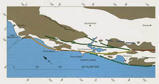
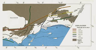
|
Figure 4.22 - Sketch map of western and southwestern California, showing selected major faults exhibiting evidence of Quaternary activity in the San Andreas fault system. Average Quaternary slip rates are based on measured values from published sources and, where measurements are incomplete or unavailable, on interpreted geologic and geomorphic evidence. Slip components on northwest-trending faults are predominantly horizontal, right lateral, and consistent with North American-Pacific plate motion Group of east-west-trending faults between lat 34°00' and 35°30' N. exhibit a more complex slip pattern, including chiefly reverse faulting but also some strike slip. Areas above 600-m elevation (colored) exhibit evidence of late Cenozoic uplift and enclose most areas of Quaternary uplift, but elevation pattern reveals no such major local uplifts as those near Ventura (approx 1 cm/yr) and along the Newport-Inglewood fault zone (NI). Faults dotted where concealed by water.
|
|
Despite many still-unsolved problems and unanswered questions, the San Andreas fault system has proved a productive laboratory in which to pursue three tasks: to quantitatively evaluate earthquake hazards in the densely populated, high-risk regions of California; to develop new investigative and analytical methods that can be applied in other regions of high earthquake risk; and to better understand how geologic processes deform the Earth's crust at plate margins. None of these tasks is finished, but the progress so far has improved our knowledge of crustal-deformation processes and aided our efforts to reduce the hazards from damaging earthquakes.
REFERENCES CITED
|


