Earthquake
and Tsunami of 23 June 2001 in Southern Peru
George
Pararas-Carayannis
Copyright © 2001.
All Rights Reserved

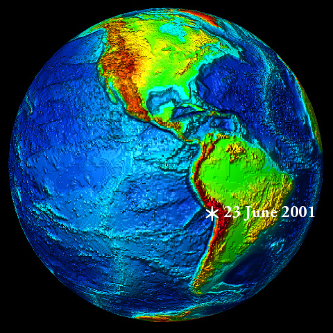 Introduction Introduction
A major earthquake with
a Richter magnitude of 8.1 occurred in Peru at 2033 UTC (4:33
PM EDT, 3:33 PM local time) on Saturday, June 23, 2001. The quake
damaged extensively southern Peru, particularly the Arequipa-Moquegua-Tacna
area. Strong ground motions were felt as far as Bolivia and northern
Chile.
The quake caused several
landslides and generated a local destructive tsunami. A small
tsunami was also observed or recorded at distant locations in
the South and Central Pacific and in Japan.
Epicenter
The epicenter of the
quake was off the coast, at 16.15S 73.40W, just north of the
town of Ocona in Southern Peru, aproximately 375 miles (600 km)
southeast of Lima and 120 miles (190 km) west of Arequipa. Its
focal depth was listed as shallow (less than 33 Km), but USGS
Moment Tensor Solution gives as 9 km deep.
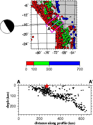
Aftershocks
Following the main quake,
dozens of aftershocks were recorded , the largest being a magnitude
6.8. Periodic aftershocks continued in subsequent days. The distribution
of initial major afterhocks is shown in the map below which also
shows the approximate tsunami. generating area.
Motions
According to reports,
ground motions in the affected region lasted for more than a
minute. The motions were so strong that even in Peru's capital,
Lima (600 km away), homes collapsed and injured several people.
The highest intensities were observed in the provinces of Arequipa,
Moquegua and Tacna. The quake was felt strongly in many cities
of Bolivia and Northern Chile.
Tectonic
Setting
The earthquake occurred
along an area of high seismicity on the west coast of Peru. It
was caused from thrust faulting along the boundary where the
Nazca plate subducts beneath the South American plate. This is
one of the three distinct seismic zones in the Peruvian upper
mantle (Ocola1966).
The activity of this
zone is most pronounced on the western side and lies between
the Andean mountain block and the Peru-Chile Trench. This narrow
seismic band (100-150 Km wide) is under Peru's Continental Shelf
and is characterized by shallow earthquake activity and has great
tsunamigenic potential
(Pararas-Carayannis,
1968, 1974).
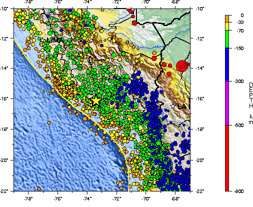 Epicenter
of the June 23, 2001 Earthquake / Seismicity of Southern Peru
(Modified USGS graphic)
Epicenter
of the June 23, 2001 Earthquake / Seismicity of Southern Peru
(Modified USGS graphic)

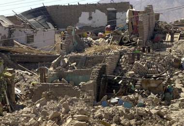 Earthquake
Effects - Deaths and Damage Earthquake
Effects - Deaths and Damage
The strong earthquake
caused great damage throughout the southern region of Peru as
well as in Lima. The most affected regions were the provinces
of Arequipa, Moquegua and Tacna. In Arequipa and Moquegua, 80%
of the homes were damaged as well as highways, water aquaducts
and electrical systems.
Damage in
Southern Peru from the Earthquake of June 23, 2001
The quake practically
destroyed the agricultural infastructure of this region by causing
the destruction of water reseroirs, canals and bridges. Santa
Rita de Sigua, the principal irrigation canal in this agricultural
region, collapsed for 300 meters - closing also the Pan-American
highway.
The number of dead,
injured and missing continued to rise in the days following the
main earthquake. As of June 26, according to Peru's Civil Defense
Institute, 118 people were killed, another 1,578 people were
injured, 53 were unaccounted and 47,696 were left homeless. A
total of 21,189 homes were damaged or completely destroyed. These
represent estimates which will probably rise.
Lima -
Falling debris and
collapsed homes injured several people in Peru's capital.
Arequipa - The
worst damage occurred in this historic city. Arequipa, about
465 miles south of Lima, is Peru's second largest city with population
of over one million people. There were at least 73 fatalities
there. The quake destroyed historic homes and cathedrals, many
of which had been rebuilt after the destructive 1868 earthquake.
 Region of Tacna - Dozens of adobe homes in the southern city of
Tacna, near the border with Chile, were destroyed. Major damage
occurred also in the zone known as La Yarada, where the electrical
system was affected. There was extensive damage also to the irrigation
aquaducts in the valleys of Sama, Locumba and Tacna. 13 people
were reported killed in Tacna, and 8 people were killed in Ayacucho. Region of Tacna - Dozens of adobe homes in the southern city of
Tacna, near the border with Chile, were destroyed. Major damage
occurred also in the zone known as La Yarada, where the electrical
system was affected. There was extensive damage also to the irrigation
aquaducts in the valleys of Sama, Locumba and Tacna. 13 people
were reported killed in Tacna, and 8 people were killed in Ayacucho.
Moquequa - This mining town, about 865 miles
south of Lima, was also hard-hit by the quake. A landslide blocked
one of the town's chief roads and many houses collapsed. 24 people
were reported killed and many more were injured.
Characato - This Andean highland town was extensively damaged.
Past Earthquake
Disasters in Peru
The last major earthquake
(7.7 magnitude) to strike along the Nazca subduction zone of
Peru, occurred on November 12, 1996. It killed 17 and injured
about 1,500 people. On May 30, 1990, an earthquake (6.3 magnitude)
in northern Peru killed 137 people. On May 31, 1970 another major
earthquake (7.7 magnitude) killed approximately 70,000 people.
On October 17, 1966, a strong earthquake (7.5 magnitude) off
the coast of Pativilca, severely damaged Central Peru. Also,
this event generated a large tsunami which caused destruction
along a 400 Km long coastal belt in Peru, from Chimbote in the
North to San Juan in the South - including sectors of Lima-Callao
(Pararas-Carayannis,
1968, 1974).
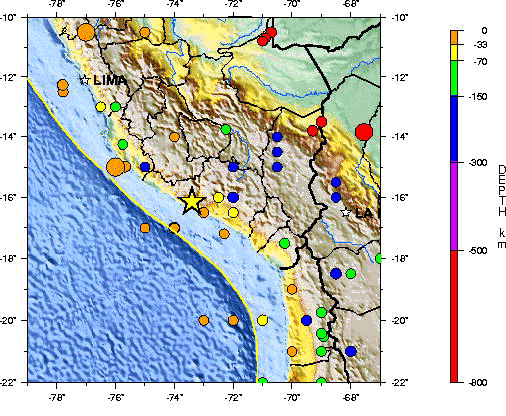
Epicenters
of major historical earthquakes in Southern Peru since 1900,
including the June 23, 2001 event (star) (USGS graphic - modified)
The
Tsunami of June 23, 2001 in Southern Peru
The June 23, 2001 earthquake
generated a destructive, local tsunami which struck the coastline,
primarily near the epicenter region in southern Peru, approximately
20 minutes after the main earthquake shock. Tsunami waves with
runups ranging from10 - 15 feet or more were reported. In some
coastal areas, the tsunami waves swept one to two miles inland.
According to reports,
2,500 hectáreas of agricultural land were inundated in
Camaná - a popular and picturesque summer resort of around
20,000, some 560 miles (900 km) south of Lima. This was one of
the hardest-hit areas by both the earthquake and the tsunami.
The tsunami swept more than a half-mile inland over the town
and its surrounding rice and sugarcane fields. According to Peru's
Civil Defense, as of June 26th, at least 20 persons were reported
as drowned by the tsunami and another 60 persons as missing.
These figures are expected to rise.
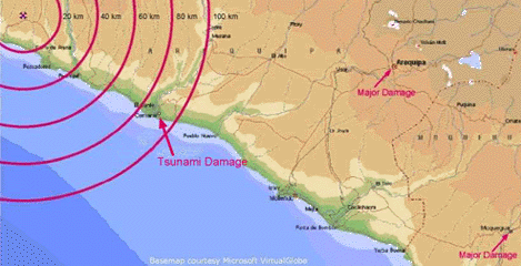 Earthquake
and Tsunami Damage of the June 23, 2001 Ear (Modified USGS graphic)
Earthquake
and Tsunami Damage of the June 23, 2001 Ear (Modified USGS graphic)
Tsunami Warning
Issued
Based on the earthquake's
large magnitude, initial visual reports of a tsunami, and recordings
from tide gauges in this region, the Pacific Tsunami Warning
Center in Honolulu issued a Regional Tsunami warning and watch
for Peru, Chile, Ecuador, Colombia, Panama, Nicaragua, El Salvador,
Mexico and French Polynesia. The Tsuanami Warning and Watch was
posted at 20:41 UTC, on 06/23/01.
 Tsunami Recordings and
Observations at Distant Locations Tsunami Recordings and
Observations at Distant Locations
Small tsunami waves
measuring a few centimeters were recorded or observed in southern
and Central Pacific and as far away as Hawaii and Japan. According
to the Pacific Tsunami Warning Center's Bulletin in Honolulu,
the following Initial tsunami wave measurementsts were reported
from tide stations in Peru and Chile.
ARICA, CHILE 2.5
METERS PEAK-TO-TROUGH; PERIOD = 15 MINUTES
IQUIQUE, CHILE 1.5
METERS PEAK-TO-TROUGH PERIOD = 20 MINUTES
ANTOFAGASTA, CHILE 0.9
METERS PEAK-TO-TROUGH PERIOD = 18 MINUTES
CALLAO, PERU 0.4
METERS PEAK-TO-TROUGH PERIOD = 14 MINURES
CALDERA, CHILE 1.0 METERS PEAK-TO-TROUGH PERIOD
= 16 MINUTES
JUAN FERNANDEZ, CHILE 0.8
METERS PEAK-TO-TROUGH PERIOD = 10 MINUTES
VALPARAISO, CHILE 0.5
METERS PEAK-TO-TROUGH PERIOD = 18 MINUTES
SAN ANTONIO, CHILE 0.4
METERS PEAK-TO-TROUGH PERIOD = 18 MINUTES
COQUIMBO, CHILE 1.0
METERS PEAK-TO-TROUGH PERIOD = 20 MINUTES
SANTA CRUZ, GALAPAGOS 0.6
METERS PEAK-TO-TROUGH PERIOD = 16 MINUTES
CORRAL, CHILE 0.3
METERS PEAK-TO-TROUGH PERIOD = 18 MINUTES
TALCAHUANO, CHILE 1.0
METERS PEAK-TO-TROUGH PERIOD = 16 MINUTES
SAN ANTONIO, CHILE 0.3
METERS PEAK-TO-TROUGH PERIOD = 15 MINUTES
The greatest tsunami
oscillation of 30cm peak to trough was recorded at Port Vila,
Vanuatu, in the Southern Pacific. Additional tide gauges in the
Central and South Pacific (Apia, Fanfuti, kembla, Lautoka, Lombrum,
Nukualofa, Rarotonga and Suva) recorded a small tsunami.
In Honolulu, Hawaii,
a small influx of the tsunami was observed in the Kapalama and
Nuuanu Streams, beginning at approximately 0030 hours of June
24th. The observed water movements had an apparent period of
15-20 minutes.
Tsunamis in
Peru
Large earthquakes occur
frequently in Peru. Major earthquakes occurred on 9 July 1586,
13 November 1655, 20 October 1687, 28 October 1746, 30 March
1828, 24 May 1940 (M=8.4), 17 October 1966 (M= 7.5), 31 May 1970
(M= 7.7), 3O May 1990 (M=6.3) and 12 November 1996 (M=7.7). Of
these, the earthquakes of 1586, 1687, 1746, 1828 and 1966 produced
destructive tsunamis
(Iida, Cox;
and Pararas-Carayannis, 1968, Pararas-Carayannis, 1968, 1974). To this list we must now add the
June 23, 2001 event.
The last major tsunami
to strike Peru was on October 17, 1966. It affected a coastal
belt 400 Km long, causing destruction from Chimbote in the North
to San Juan in the South. The greatest wave at Callao had a range
of 3.40 m height (range between maximum crest and trough) and
tsunami waves exceeding 3 meters in amplitude (height above undisturbed
water level) inundated La Punta, Chuito, Ancon, Huaura, Huacho,
and the resort of Buenos Aires in the City of Trujillo. Devastating
effects were experienced at the port of Casma (about 360 Km north
of Lima) and at Calota Tortuga, where waves exceeded 6 meters
in range. Tsunami destruction also occurred at Puerto Chimu and
Culebras. The 1966 tsunami caused no damage outside Peru, but
was recorded by tide gauges throughout the Pacific Ocean (Pararas-Carayannis,
1968, 1974).
Fault and
Azimuthal Orientation of the Tsunamigenic Area
The azimuthal orientation
(and quake faulting) of a tsunamigenic area can be determined
or deduced from analysis of seismic or oceanographic data (Pararas-Carayannis,
1965,1968, 1972, 1974).
 Seismic data analysis: The nature of the first seismic
motion related to an earthquake depends on the crustal displacement
of the source. The impulse of P (compressional) waves indicates
a vibration in a plane containing the great circle that passes
through the epicenter and the seismic station recording an earthquake
(Galitzin,1909). Seismic data analysis: The nature of the first seismic
motion related to an earthquake depends on the crustal displacement
of the source. The impulse of P (compressional) waves indicates
a vibration in a plane containing the great circle that passes
through the epicenter and the seismic station recording an earthquake
(Galitzin,1909).
If the first impulse
on the vertical component of the seismograph is up, the first
phase of P wave is a compression, so the composition of north-south
and east-west is in a direction away from the epicenter. A composition
of the three components gives the direction of the first displacement
of the ground, which however is not the exact direction of the
path of the incident wave. It is rather the combination of the
amplitudes of the incident P wave and the reflected P and S (shear)
waves that give an indication of the motion of the surface of
the ground.
A single force sends
compression waves into a half space and rarefaction waves into
the other half space; a couple sends alternate compressions and
rarefactions into quarter spaces (Nakano,1923).
Modal planes of the
focus can be deduced from recordings of compressions and rarefactions (Byerly,1955). Such
a pattern can be considered a function of the azimuth to be expected
from a seismic source. From this and the distribution of aftershocks,
the tsunamigenic area can thus approximated.
A projected single straight
line on the map therefore, indicating the fault, should separate
regions where the first motion was compression from those where
it was a rarefaction, and the strike of the fault and orientation
of the earthquake source region (and indirectly the tsunamigenic
area) can be determined from a pattern of compressions and rarefactions.
Additionally, the tsunamigenic
area of an earthquake can be deduced indirectly from oceanographic
parameters by refracting tsunami waves back to the source from
tide gauge stations which recorded the tsunami, and for a length
of time equal to the travel time to each station. Using several
stations and based on water wave refraction analysis, an approximate
envelop can be established giving the approximate orientation
and dimensions of the tsunamigenic area
(Pararas-Carayannis,
1965, 1972, 1974).
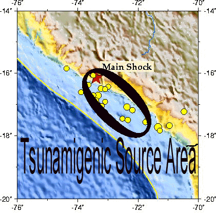
A review of the earthquake
aftershock distribution and the moment tensor analysis of the
June 23, 2001 earthquake indicate that the fault rupture and
the tsunamigenic area (an approximate ellipse), had a general
trend striking at 284 degrees with a dip=7 and a slip=45.
The adjacent map shows
the approximate dimensions and orientation of the tsunamigenic
area of the June 23, 2001 event. This tsunamigenic area may be
refined as more data and tsunami wave refraction analysis is
performed. The azimuthal orientation of the tsunami generating
area provided here, is in agreement with the general trend of
the fault systems, the Andean Mountains, and the Peru -Chile
Trench in this region.
The nature of first
water motion observed at stations near the epicenter and consideration
of the tsunami travel path, in addition to the seismic evidence,
support the conclusion of a tsunami generating area having orientation
which paralleled the coast - as shown in the illustration above.
 Ocean Floor Displacements
and Initial Tsunami Height Ocean Floor Displacements
and Initial Tsunami Height
Crustal displacements
were of a dipole nature (negative and positive) along a thrust
fault approximately paralleling the Peruvian coast. The maximum
vertical uplifted portion (appr. 1.8 m) was on the continental
side of the rift and the downward portion ( appr. 1.8) on the
oceanic side of the rift. However, these represent maximum crustal
displacement values diminishing away from the rift zone. Upward,
ground displacements must have also occured on land along the
affected coastal area - but these remain to be determined by
geological surveys.
The June 23, 2001 earthquake
in Peru was very shallow in depth and this may have limited the
extent of the tsunamigenic area. The quake had a predominantly
lateral strike slip with a smaller component of vertical dip
slip motion. It is the latter motion that generates tsunamis.
Total crustal displacement is the resultant of the horizontal
strike slip, "X", and the vertical dip-slip, Z, related
by:
TOTAL DISPL= {X (raised to2) + z (raised to the 2)} raised to
1/2
As of the writing of
this report, the horizontal strike slip and the vertical dip
slip for this event are not known with certainty - although the
maximum vertical crustal displacement is estimated at 1.8 meters.
However, statistical relationships between maximum crustal displacement
and earthquake magnitude M have been compiled, and working curves
have been plotted ( Wilson 1964, 1969). Although such empirically derived curves display
scatter of data - possibly because of differences in the focal
depth and geology of each region associated with each seismic
event - a median value can be selected as being reasonable for
shallow -focus tsunamigenic earthquakes.
For the June 23, 2001
earthquake (M = 8.1), the median value of crustal displacement
along the fault taken from such curve is = 5. 4m.
If we assume an extreme
ratio of strike-slip: Dip-slip, 10:3, then dip-slip, or vertical
movement of the ocean floor along the fault, is estimated from
the equation above to be, Z = 1.78m.
Vertical displacements
of the seismotectonic block responsible for tsunami generation
will decay exponentially with distance normal to the fault in
accordance to the elastic rebound theory
( Reid 1910). The ocean area affected by such
displacements, the tsunami generating area, is an approximate
ellipse in which the fault occupies the major axis. The leading
tsunami waves are generated from the periphery of this area -
and their arrival at nearby stations - is indicative of the initial
ocean floor displacement. Maximum runup on the shore, is generally
caused by the crest of the tsunami wave near the fault.
Based on the above assumptions
of vertical ocean floor displacements, the initial tsunami height
in the generating area is estimated at a maximum of 1.5 - 1.78
meters above the undisturbed sea level.
Given, therefore, the
magnitude, depth, and epicenter of the earthquake, and utilizing
the assumptions and empirical relationships outlined here, the
runup along Southern Peru from tsunamis originating from this
seismic region can be roughly approximated. Considering that
the waves reaching the immediate coastline of Southern Peru had
maximum runups of about 5 meters , the shoaling and resonance
amplification factor on this coast for local tsunamis is estimated
to be about about 8.5 times the maximum deep water value (1.78
X 8.5 = 15.13 meters).
Fault Length
Statistical relationships
between fault length L (Km) and earthquake magnitude (M) have
been also worked out. Using a statistical relationship (Ambraseys
and Zatopek , 1968),
Log L = 1.13 M - 6.4
Since the earthquake
of June 23, 2001 had a magnitude of 8.1, the fault length is
estimated to be of about 152 kms . However, it should be emphasized
that this is a rough estimate and that this particular earthquake
was fairly shallow.
Tsunami Generating
Area
The tsunami generating
area of the June 23, 2001 earthquake can also be approximated
by reverse wave refraction analysis from different tide recording
stations in the immediate area (i.e Lima-Callao, San Juan, Iquique,
Arica, Valparaiso, Antofagasta and possibly Honolulu, Rikitea,
or Papeete). The actual arrival time of the first tsunami wave
at each of these stations can be obtained from the tide gauge
record and compared with the estimated travel times issued by
the Pacific Tsunami Warning Center's initial Bulletin. Thus,
appropriate corrections can be made and the tsunami area can
be approximated on a map.
The following estimates
of first tsunami wave arrival were provided by the Pacific
Tsunami Warning Center with its initial warning message.
Table 1. Estimated
and Actual Travel Times of First Tsunami Wave Arrival. (Date
and Time of Quake, June 23, 2001, 2033 UTC)
Estimated Actual
CHILE - IQUIQUE 2125Z 23 JUN
ARICA 2137Z 23 JUN
ANTOFAGASTA 2159Z 23 JUN
CALDERA 2220Z 23 JUN
COQUIMBO 2255Z 23 JUN
VALPARAISO 2305Z 23 JUN
TALCAHUANO 0039Z 24 JUN
EASTER IS 0215Z 24 JUN
PUERTO WILLIAMS 0511Z 24 JUN
PUERTO MONTT 0818Z 24 JUN
PUNTA ARENAS 0834Z 24 JUN
PERU - LA PUNTA 2214Z 23 JUN
ECUADOR - BALTRA IS. 0055Z 24 JUN
COLOMBIA - TUMACO 0104Z 24 JUN
BUENAVENTURA 0110Z 24 JUN
BAHIA SOLANO 0135Z 24 JUN
PANAMA - BALBOA
HTS. 0303Z 24 JUN
NICARAGUA - PUERTO SANDINO 0305Z 24 JUN
CORINTO 0310Z 24 JUN
SAN JUAN DL SUR 0316Z 24 JUN
EL SALVADOR - ACAJUTLA
0324Z 24 JUN
MEXICO - ACAPULCO 0342Z 24 JUN
MANZANILLO 0434Z 24 JUN
SOCORRO 0505Z 24 JUN
FR. POLYNESIA - RIKITEA
0559Z 24 JUN
PAPEETE 0808Z 24 JUN
Wave refraction analysis
has not as yet been undertaken for the June 23, 2001 event. However,
based on the estimated fault length, the tsunami generating area
is rougly calculated to cover about 17,200 sq. Km. Using these
source dimensions, and assuming that the total energy is equal
to the potential energy of the uplifted or depressed volume of
water, the total energy for the tsunami can be approximated by:
ESTIMATE OF TOTAL TSUNAMI
ENERGY (t) = 1/6 p.g.h(raised to 2). A=
= 1/6(1.03)(.980)(10 raised to 3)(10 raised to 4)(.55 raised
to 2)( 17,200 sq. km)= 8.99 x 10 raised to the 19 ergs.
Where Et= Total energy
p = 1.03 g/cm = Density
of sea water
g = 980 cm/sec = gravitatioanl acceleration
h = Assumed average height of crustal displacement (throughout
tsunamigenic area)= .55 m
A = Tsunami generating area = 17,200 Km
1 erg = g cm sec .
Considering that the
energy of the June 23, 2001 earthquake (magnitude 8.1) was very
large, the energy responsible for tsunami generation is a small
fraction and is roughly estimated to be only 1/1,500 of the total
energy of this event.
Tsunamigenic
Potential of the Southern Peru Segment of Subduction along the
Peru-Chile Trench
The Peru-Chile Trench
is a manifestation of very active subduction along the South
American continent. Most of the destructive tsunamis along the
South American coast have been generated from major, shallow
earthquakes - east but in close proximity to the Peru-Chile Trench.
Deeper earthquakes, along the Beniof Zone (which is quite wide
and flat in this area of Southern Peru) do not produce tsunamis.
Historically, the large earthquakes along the Peru-Chile Trench
above latitude 16 degrees South have produced locally destructive
tsunamis but not destructive Pacific-wide tsunamis. The real
destructive Pacific-wide tsunamis have been generated a little
further south along the coast of Chile. The 1868 Pacific wide
tsunami, characterized as the "Great Peru earthquake and
tsunami", which destroyed Arica (then part of Peru), had
its epicenter further south - in what is now northern Chile (around
18.5 South). The 1960 Pacific-wide tsunami was generated by a
huge earthquake which had its epicenter at about 37.5 South latitude.
The reason this tsunami was so destructive in Hawaii, Japan and
elsewhere in the Pacific, was that the 1960 earthquake's rupture
extended along a strike length of about 900-lOOOkm.
Review of the historic
record indicates that most of the earthquakes along the entire
coast of Peru have had relatively short rupture lengths and therefore
have generated only local destructive tsunamis. For example the
1966 tsunami which was generated by a large earthquake in the
central part of Peru's seismic zone 4, had a rather short rupture
of about 120 km (Pararas-Carayannis, 1968, 1974). It
did not produce a Pacific-wide tsunami. Similarly, the June 23,
2001 Peru earthquake had a relatively short rupture (estimated
at 152 km) and it did not generate a large Pacific- wide tsunami.
The obliquity of convergent
tectonic plate boundaries along this region of southern Peru
may be the reason for the shorter rupture lengths. The gradients
in obliquity appear to change south of 18.5 South Latitude as
a consequence of the geometry of tectonic plate motions. Rupture
lengths of major earthquakes are longer and the tsunamigenic
potential is greater, further south. For example, the May 9,1877
(Mw 8.8) quake near Iquique, had a rupture of about 420 km along
the coast of Chile and extended from 18 South to 23 South and
generated a destructive Pacific-wide tsunami. The tsunami wave
heigths reached 24 meters in Chile and up to 5 meters in Hawaii (
Pararas-Carayannis 1969; Pararas-Carayannis andCalebaugh, 1977).
Further south, the November
10, 1922 earthquake (Mt 8.7) in Northern Chile, had a rupture
of about 300-450 km-long, extending from about 26.1 to 29.6 South.
It generated also a Pacific-wide tsunami - although not as large
as that generated by the 1877, or 1868 earthquakes.
Summary and
Conclusions
The source mechanism
of tsunami generation associated with the earthquake of 23 June
2001 is inferred based only on a cursory review of some of the
seismic and oceanic parameters associated with this event.
The seismic mechanism
is inferred from geologic structure, seismic intensities, energy
releases, spatial distribution of aftershocks, and fault plane
solutions. Using this information and some empirical relationships
of seismic parameters, the fault length, azimuthal orientation
of the tsunamigenic area and estimated initial tsunami height,
are provided. Reverse wave refraction analysis will be needed
to estimate more accurately the limits of the tsunami generating
area. The crustal displacements and energy which contributed
to tsunami generation need to be refined. However, based on this
preliminary review, the following conclusions can be made:
a. The June 23, 2001
earthquake occurred in the western part of an active seismic
belt that lies between the Andean mountain block and the Peru-Chile
Trench. This seismic region has been responsible for a number
of major earthquakes within recorded history and local destructive
tsunamis.
b. The spatial distribution
of aftershocks associated with the main earthquake correlate
well with known seismotectonic trends and the seismic velocity
structure anomalies which are characteristic of thrust fault
systems at continent-ocean boundaries.
c. The fault and azimuthal
orientation of the tsunamigenic area were aligned with crustal
displacements along a thrust fault system which parallels the
Peruvian coast. Seismic and water motion data indicate that the
uplifted portion of the crustal block was on the continental
side of the rift.
d. The tsunami was generated
by displacements of a crustal block with a total area estimated
at 17,200 sq. km. Its energy was calculated to be 8.9 x 10 (raised
to the 19 power) ergs, or approximately 1/1,500 of the earthquake
energy.
e. The segment of subduction
and faulting along and paralleling the Peru-Chile Trench (from
about 15 to 18 South Latitude) and the obliquity of convergent
tectonic plate boundaries in this region of Southern Peru , may
be the reason for the shorter rupture lengths of major earthquakes
and the generation of only local destructive tsunamis. However,
further south (of 18 S Latitude), major earthquakes are associated
with longer rupture lengths and can generate not only local,
destructive tsunamis, but also destructive Pacific- wide events.
REFERENCES
Byerly, P. (1955). "Nature
of Faulting as Deduced from Seismograms", Geol. Soc. Am. Spec. Paper 62, 75-86.
Fisher, R. L. and Raitt,
W. R. (1962). "Topography
and Structure of the Peru-Chile Trench", Deep Sea Res., 9, 423-443.
Galitzin, B (1909). "Zur
Frage der Bestimmung des Azimuts der Epizentrums eines Bebens"; Assoc.
Internat. de Sismologie, C. R. Zermatt, 1909, pp. 132-141.
Gutenberg, B. and Richter,
C. F. (1954). "Seismicity of the Earth" 2nd Edition, Princeton Univ. Press,
Princeton, N.J., p. 310.
Gutenberg, B. and Richter,
C. (1956). "Earthquake Magnitude, Intensity, Energy and
Acceleration",
2, Bull. Seismol. Soc. Am., 46 (2), 105-143.
Iida, K., D. Cox and
G. Pararas-Carayannis, (1968). "Prelim. Catalogue of Tsunamis
Occurring in the Pacific Ocean",
Hawaii Institute of
Geophysics, Univ. of Hawaii, Data Rept. No. 5.
Lomnitz, C., and Cabre'
R. (1968). "The Peru Earthquake of October 17, 1966", Bull. Seism. Soc. Am., Vol. 58,
No. 2, pp. 645-661, April.
Ocola, L. (1966). "Earthquake
Activity of Peru",
Am. Geophys. U., Geophys. Monograph 10, 509-528.
Pararas-Carayannis,
George, and Augustine S. Furumoto (1965).
"Source Mechanism
Study of the Alaska Earthquake and Tsunami of 27 March 1964,
Part I, Water Waves", by George Pararas-Carayannis; Part
II. "Analysis
of Raleigh Wave", by Augustine Furumoto, Rept. HIG65-17,
42 pp. Honolulu: Hawaii Inst. Geophys., Dec. 1965.
Pararas-Carayannis,
G. (1968). "The
Tsunami of October 17, 1966 in Peru", International Tsunami Information Center Newsletter,
Vol. 1, No. 1, March 5.
Pararas-Carayannis,
George (1969). Catalog
of Tsunami in the Hawaiian Islands. World Data Center A- Tsunami U.S. Dept. of Commerce
Environmental Science Service Administration Coast and Geodetic
Survey, May 1969.
Pararas-Carayannis,
George and Calebaugh P.J., (1977). Catalog of Tsunamis in Hawaii, Revised and Updated , World Data Center A for Solid
Earth Geophysics, NOAA, 78 p., March 1977.
Pararas-Carayannis,
G. (1972). "The
Great Alaska Earthquake of 1964 Source Mechanism of the Water
Waves Produced",
National Academy of Sciences - Committee on the Alaska Earthquake,
Volume on Seismology and Geodesy, pp. 249-258.
Pararas-Carayannis,
G. (1974). "An
Investigation of Tsunami Source Mechanism off the Coast of Central
Peru". Marine
Geology, Vol. 17, pp. 235-247, Amsterdam: Elsevier Scientific
Publishing Company.
SEE ALSO
EARTHQUAKE AND TSUNAMI
OF FEBRUARY 21, 1996 IN NORTHERN PERU
http://drgeorgepc.com/Tsunami1996Peru.html
THE SOURCE MECHANISM
OF THE EARTHQUAKE AND TSUNAMI OF OCTOBER 17, 1966 IN PERU
http://drgeorgepc.com/Tsunami1966Peru.html
Return to

  Links to other
Pages
Links to other
Pages

 Now available
from Amazon, Barnes and Noble and other major bookstores. A signed
by the author copy can be also ordered by contacting directly
by email Aston
Forbes Press.
Now available
from Amazon, Barnes and Noble and other major bookstores. A signed
by the author copy can be also ordered by contacting directly
by email Aston
Forbes Press.
 Other
Miscellaneous Non-technical Writings
Other
Miscellaneous Non-technical Writings
(©) Copyright
1963-2007 George Pararas-Carayannis / all rights reserved / Information
on this site is for viewing and personal information only - protected
by copyright. Any unauthorized use or reproduction of material
from this site without written permission is prohibited.
|
