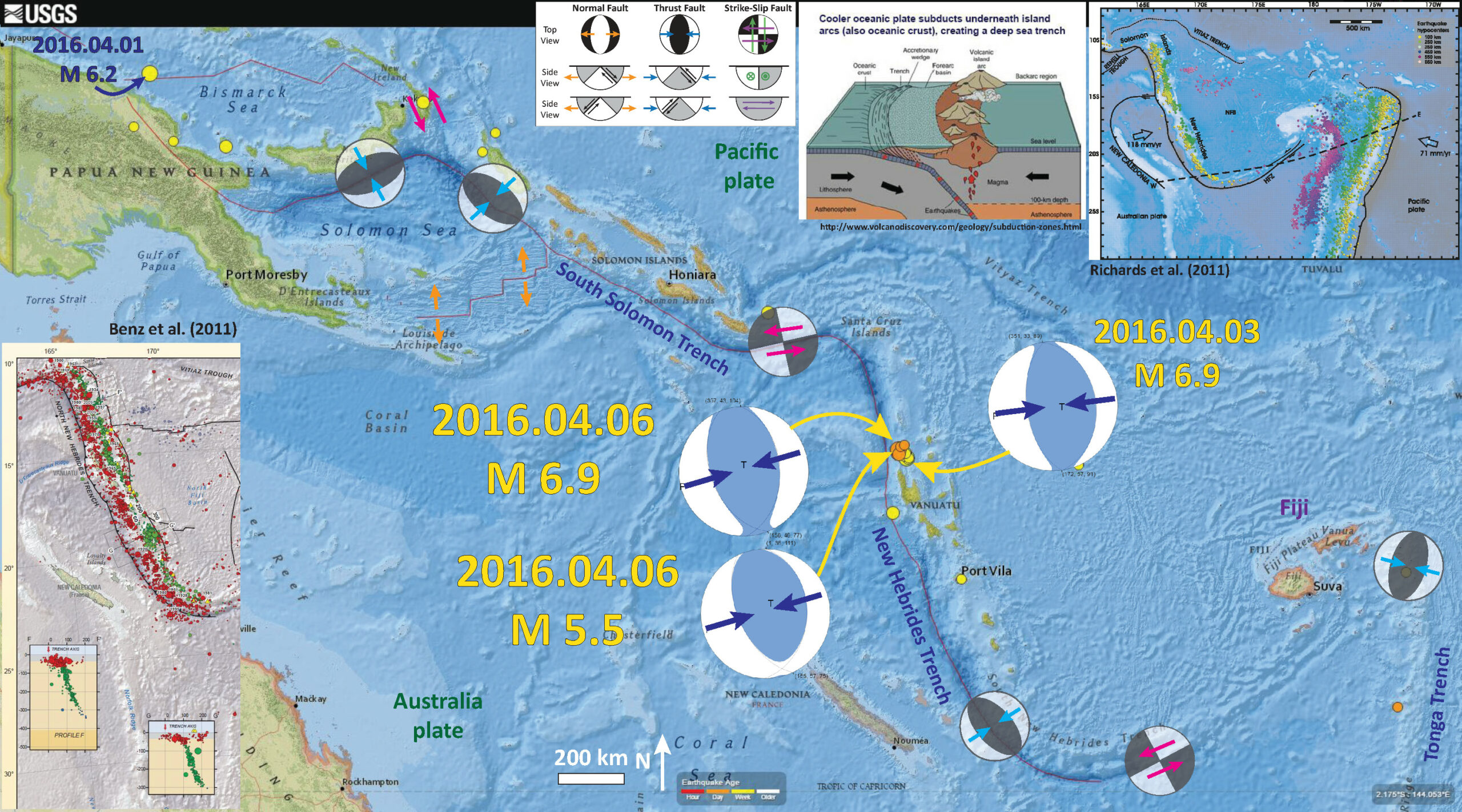
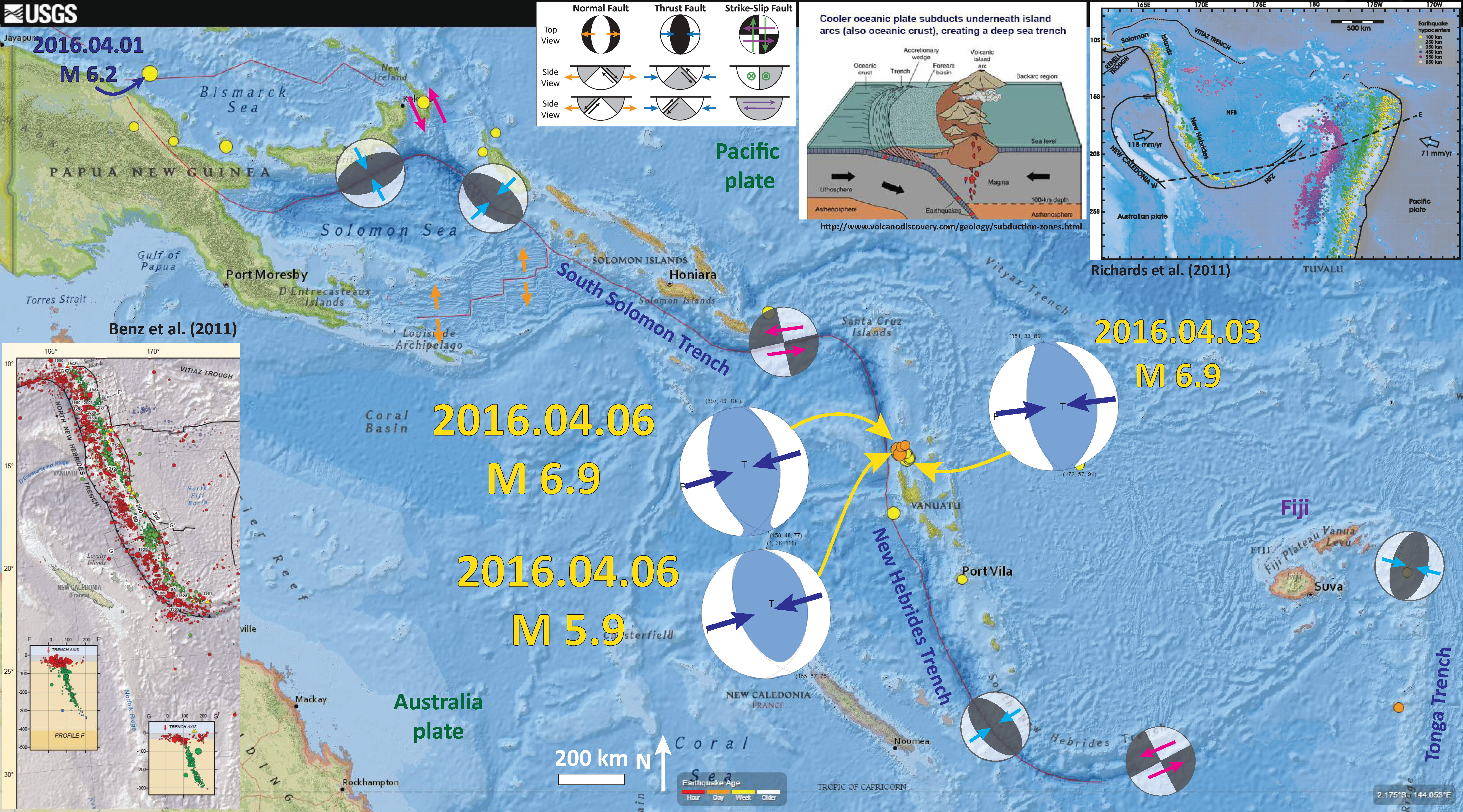
We just had another M 6.9 earthquake about 40 km from another M 6.9 earthquake from a few days ago. Here is my earthquake report from that earlier earthquake. They are both about the same depth. While the depths probably have considerable uncertainty, the new earthquake is west of the earlier earthquake. If these were on the subduction zone fault, we would consider the newer earthquake to be “up-dip” from the earlier earthquake. Indeed, the newer earthquake has a shallower depth (~33 vs ~35 km).This is probably just a coincidence, given the errors probably associated with these earthquakes. Later there was another earthquake of magnitude M = 5.5.
-
Here are the three USGS web pages for these earthquakes.
- 2016.04.03 M 6.9
- 2016.04.06 M 6.9
- 2016.04.06 M 5.5
Below is my interpretive earthquake report poster. I plot the epicenters for earthquakes from the past 7 days. The epicenter for the M 6.9 earthquake is labeled and I have placed the USGS moment tensor for reference. I include the moment tensor from the earlier earthquake as well.
I placed a moment tensor / focal mechanism legend on the poster. There is more material from the USGS web sites about moment tensors and focal mechanisms (the beach ball symbols). Both moment tensors and focal mechanisms are solutions to seismologic data that reveal two possible interpretations for fault orientation and sense of motion. One must use other information, like the regional tectonics, to interpret which of the two possibilities is more likely.
-
I include some inset figures in the poster.
- In the upper right corner is a tectonic map showing the plate boundaries (Richards et al., 2011).
- To the left of the Richards et al. (2011) figure is a cross section of a generic ocean-ocean subduction zone, where oceanic lithosphere is subducting beneath oceanic lithosphere. Note the location of the magmatic island arc. Vanuatu and the other islands in this region are formed as part of an island arc.
- In the lower left corner I place a subset of the USGS tectonic map poster for this region of the Pacific Ocean. This is from the USGS Open File Report 2010-1083-I (Benz et al., 2011). Hypocenters are plotted as cross sections to show the geometry of the subducting slabs.
-
References:
- Benz, H.M., Herman, Matthew, Tarr, A.C., Furlong, K.P., Hayes, G.P., Villaseñor, Antonio, Dart, R.L., and Rhea, Susan, 2011. Seismicity of the Earth 1900–2010 eastern margin of the Australia plate: U.S. Geological Survey Open-File Report 2010–1083-I, scale 1:8,000,000.
- Richards, S., Holm., R., Barber, G., 2011. When slabs collide: A tectonic assessment of deep earthquakes in the Tonga-Vanuatu region, Geology, v. 39, pp. 787-790.
Just had another 6.9. Super active area.
update:
http://earthjay.com/?p=3919