
This past 24 hours include two large earthquakes in the region of the Sumatra-Andaman subduction zone offshore of Sumatra. Here is a map using the USGS online GIS interface.
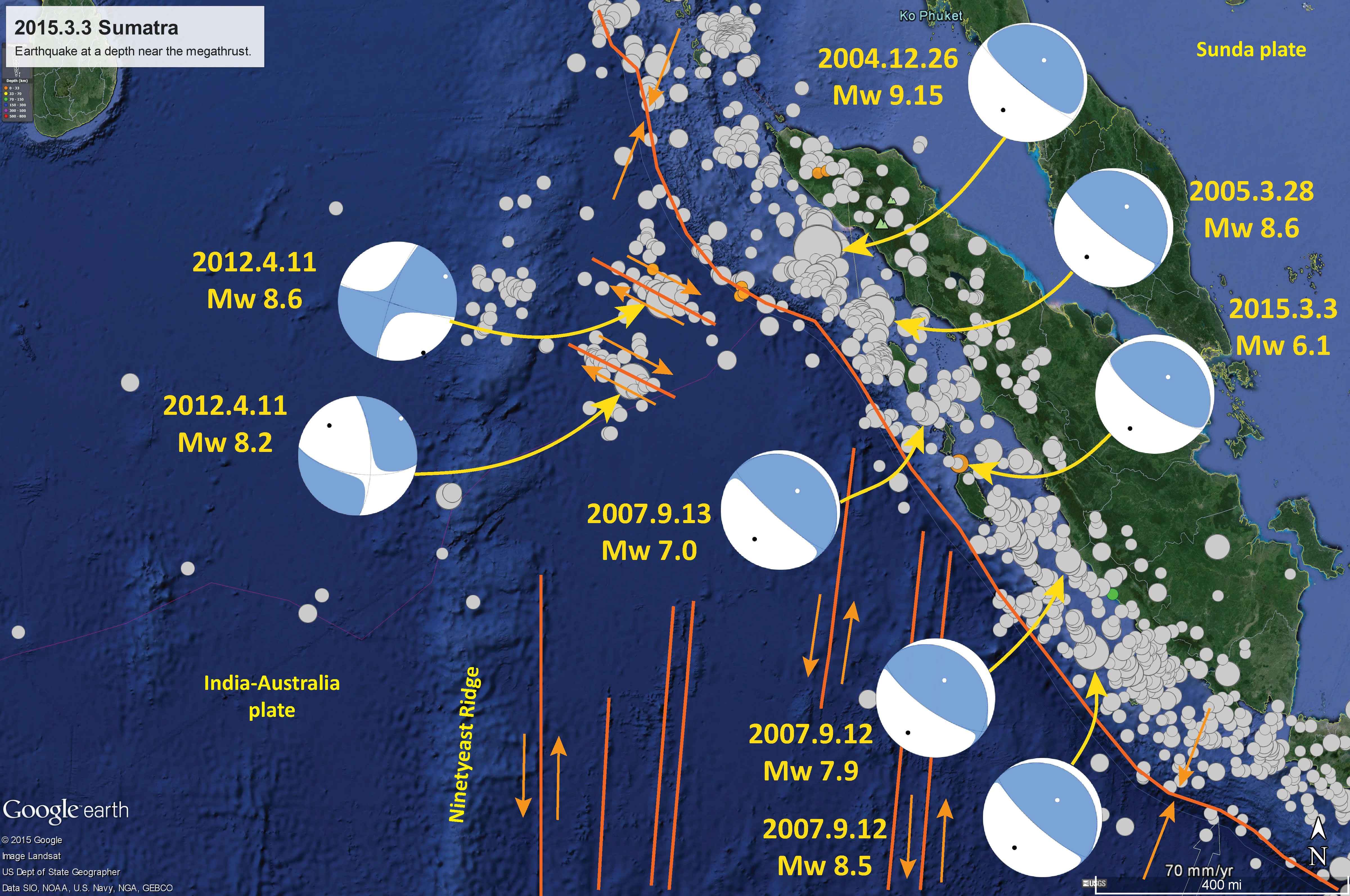
Below is a map that I prepared with the seismicity from the past week, as well as the seismicity since 1900 with earthquakes of magnitude greater than M = 7.5. I plot the slab contours (these show the depth where we think that the subduction zone fault is located; Hayes et al., 2012). I plot the moment tensors (read more below about mt data) for these two earthquakes, along with the moment tensors from four significant earthquakes since ~2004. The 2004.12.26 and 2005.03.28 earthquakes are subduction zone earthquakes. The 2012.04.11 earthquakes are the largest strike slip earthquakes ever recorded on modern seismometers. While the tectonic fabric in the India plate is dominated by north-south fracture zones (see the blue line to the right of the label “Sunda trench”), these two M~8+ earthquakes ruptured east-west faults. The oceanic crust is very thick in the region of the Ninteyeast Ridge (thought to have thickened as the crust traveled over a hot spot).
I placed a moment tensor / focal mechanism legend in the upper right corner of the map. There is more material from the USGS web sites about moment tensors and focal mechanisms (the beach ball symbols). Both moment tensors and focal mechanisms are solutions to seismologic data that reveal two possible interpretations for fault orientation and sense of motion. One must use other information, like the regional tectonics, to interpret which of the two possibilities is more likely.
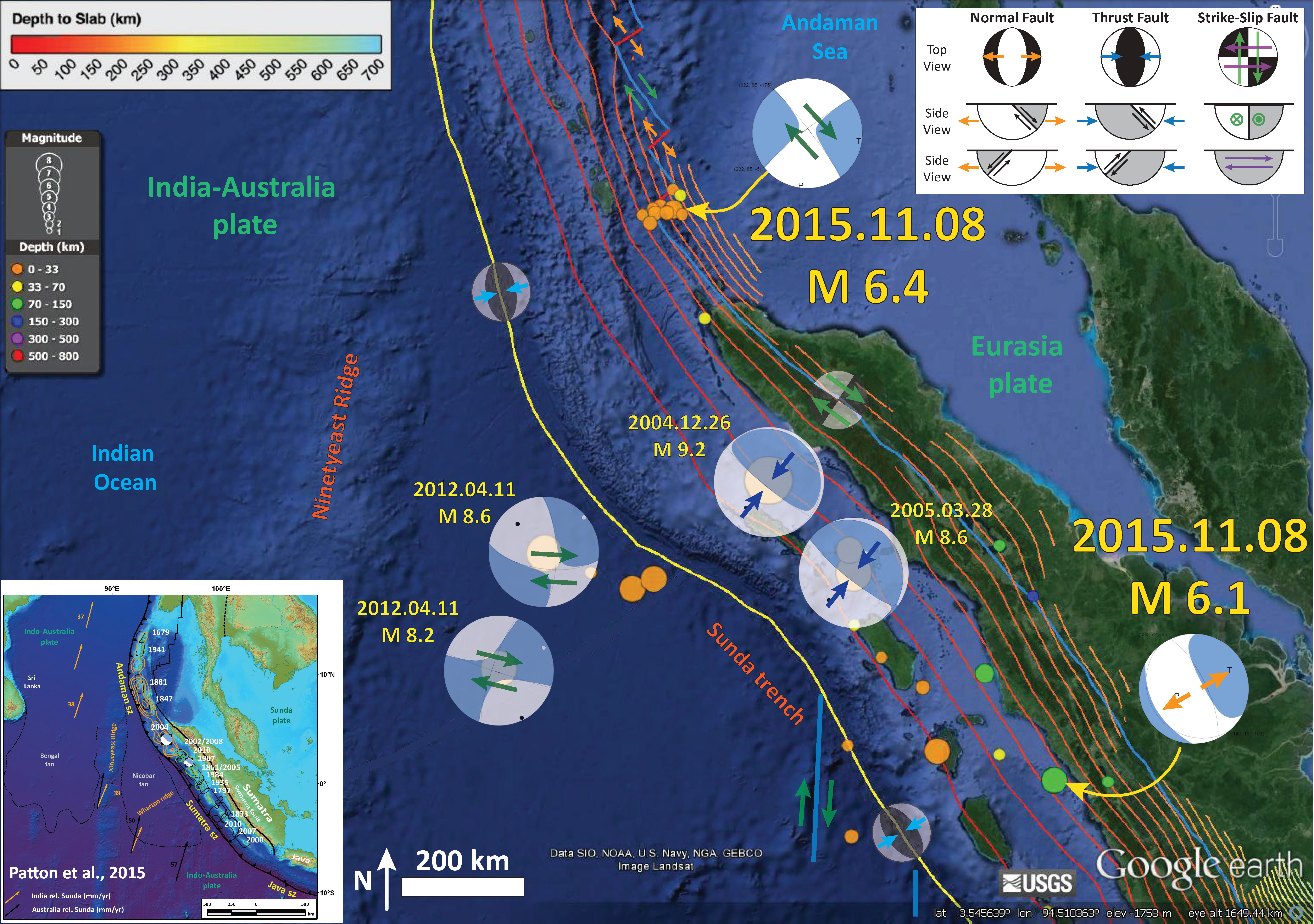
The interesting things about these two earthquakes is that they are not on the subduction zone fault interface. The M = 6.4 earthquake is shallow (USGS depth = 7.7 km). Note how the subduction zone is mapped to ~120-140 km depth near the M 6.4 earthquake. The Andaman Sea is a region of backarc spreading and forearc sliver faulting. Due to oblique convergence along the Sunda trench, the strain is partitioned between the subduction zone fault and the forearc sliver Sumatra fault. In the Andaman Sea, there is a series of en echelon strike-slip/spreading ridges. The M 6.4 earthquake appears to have slipped along one of these strike-slip faults. I interpret this earthquake to be a right lateral strike-slip earthquake, based upon the faults mapped in this region. The smaller earthquakes align in a west-southwest orientation. These may be earthquakes along the spreading center, or all of these earthquakes may be left lateral strike slip faults aligned with a spreading ridge. More analyses would need to be conducted to really know.
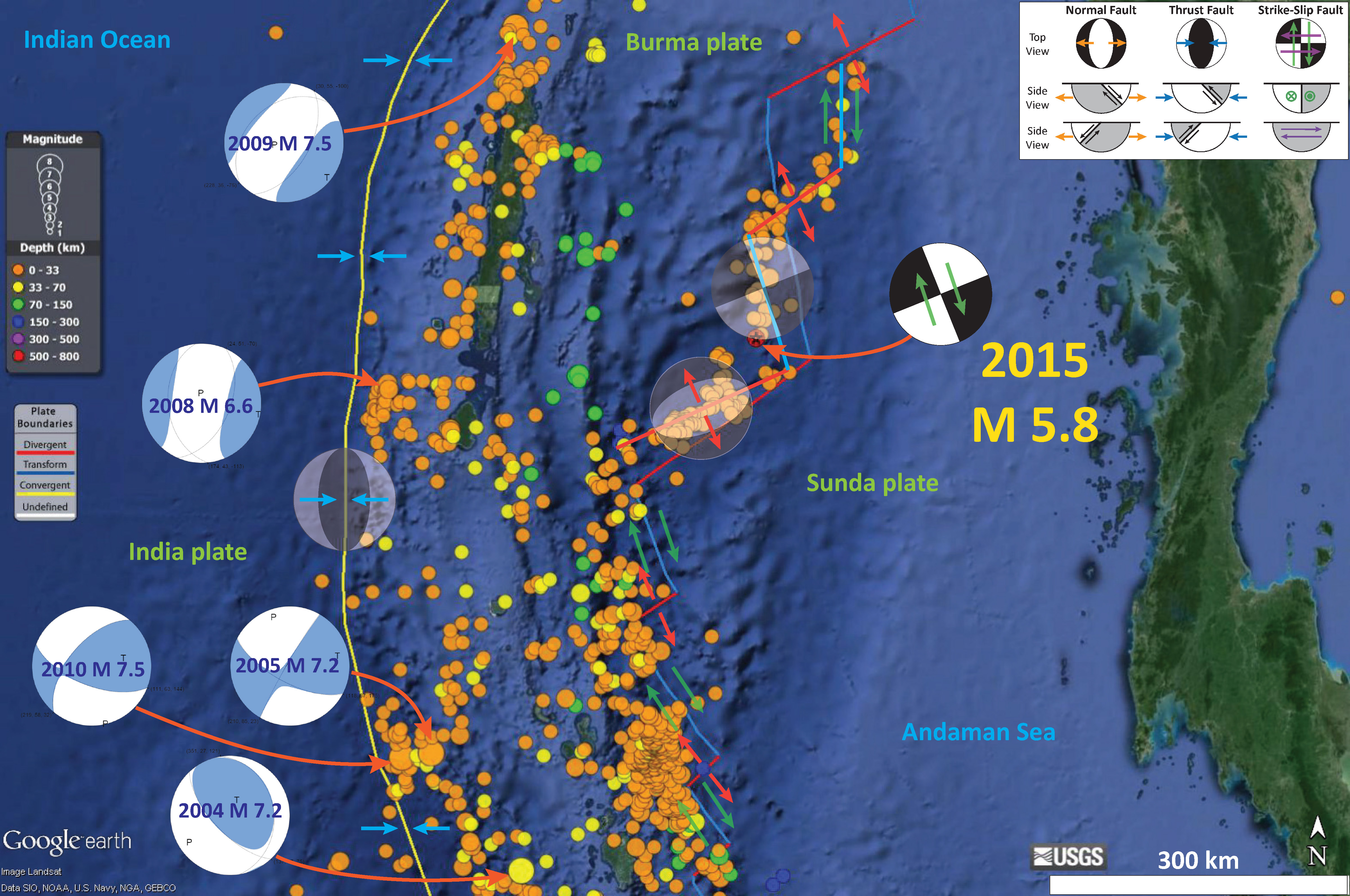
In May 2015, there was another Andaman Sea earthquake. Here is my report for that M 5.8 earthquake. Below is a map of the region. The M 5.8 did not have a moment tensor nor focal mechanism calculated, but I placed a generic strike-slip focal mechanism in an orientation that aligns with transform plate boundary that likely ruptured during this earthquake. The M 5.8 epicenter is depicted by a red and black star. I pose that this was a right-lateral strike slip earthquake along a transform plate boundary (shown in blue). Note that I have also added updated fault locations in this area, based upon seismicity (the USGS located plate boundaries are not quite correct; mine are imperfect too, but are consistent with the seismicity). The USGS fault lines have a stepped appearance and the ones that I drew look more smooth.
I placed moment tensors for some of the largest earthquakes in this region. The 2009 and 2008 earthquakes in the northwest are extensional, so are probably in the downgoing India plate (extension from bending of the plate or slab pull). The 2010 and 2005 earthquakes in the southwest are strike-slip and may be due to the oblique subduction (strain partitioning).
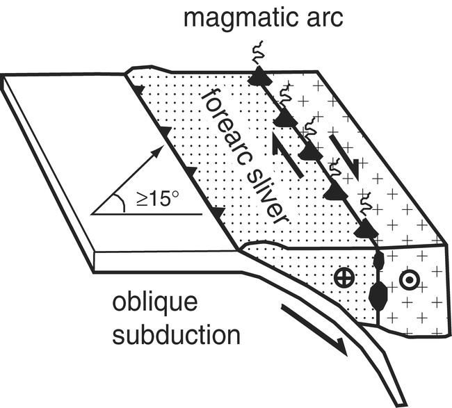
Here is a graphic that depicts how a sliver fault accommodates the strain partitioning from oblique subduction.
The M = 6.1 earthquake is a deep earthquake, based upon its USGS hypocentral depth of 75 km. The slab depth in this region is about 70 km, so this is close to the megathrust. However, these slab contours are mostly based upon seismicity, so there is considerable uncertainty regarding the precise location of the fault (Hayes et al., 2012).
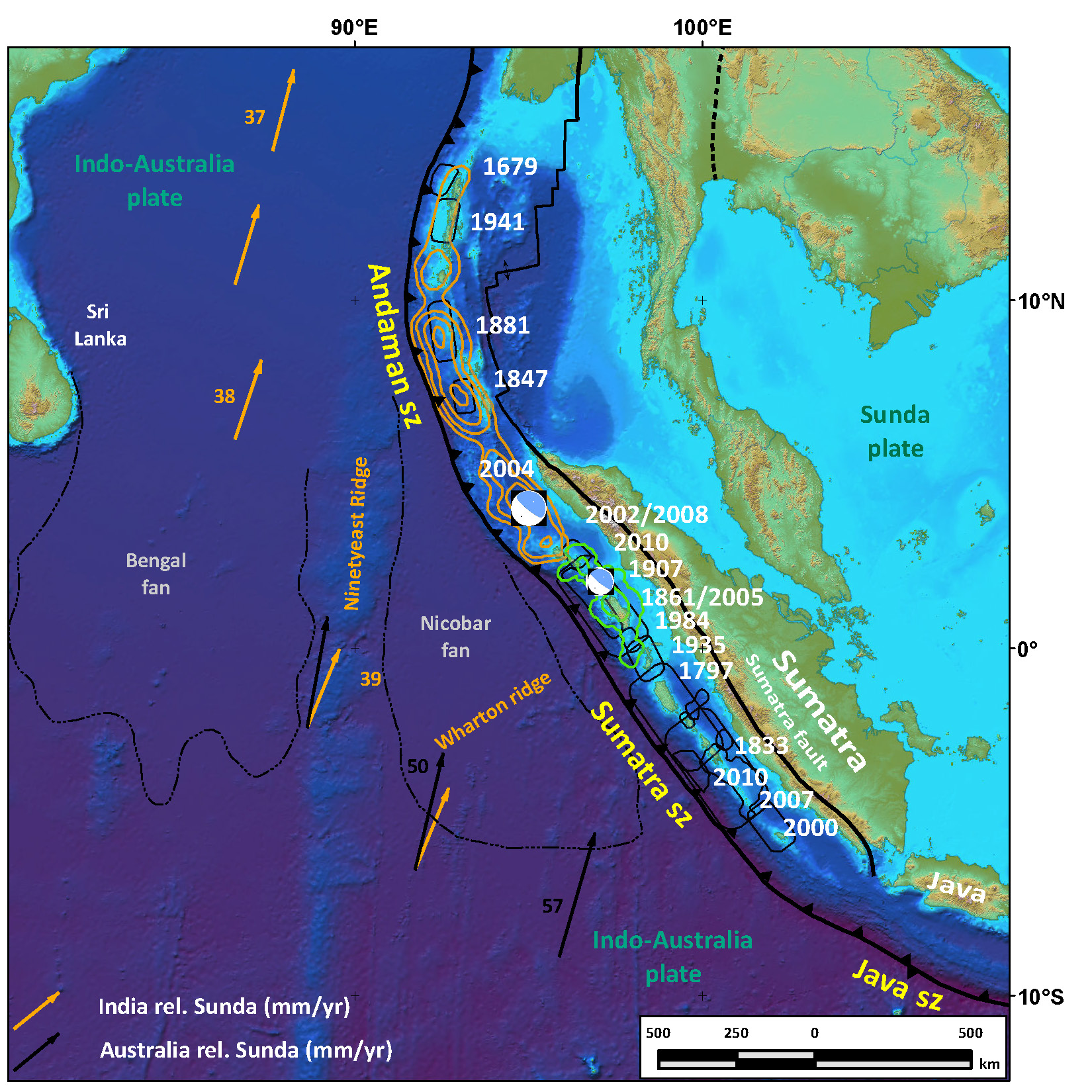
Here is a map that I just put together that shows the historic earthquakes along the Suamtra-Andaman subduction zone. Compiled multiband single beam bathymetry and Shuttle Radar Topography Mission (SRTM) topography is in shaded relief and colored vs. depth (Smith and Sandwell, 1997, Graindorge et al., 2008; Ladage et al., 2006).The India-Australia plate subducts northeastward beneath the Sunda plate (part of Eurasia; sz–subduction zone). Orange vectors plot India plate movement relative to Sunda, and black vectors plot Australia relative to Sunda (global positioning system velocity based on Nuvel-1A; Bock et al., 2003; Subarya et al., 2006). Historic ruptures (Bilham, 2005; Malik et al., 2011) are plotted in grey, calendar years are in white. The 2004 and 2005 slip contours are shown orange and green, respectively (Chlieh et al., 2007, fig. 11 therein; Chlieh et al., 2008, figure 20 therein). Bengal and Nicobar fans cover structures of the India-Australia plate in the northern part of the map; are dashed black lines delimit their southern boundaries (Stow et al., 1990). The 2004 and 2005 earthquake focal mechanisms are plotted.
-
I have two reports about the 2004 Sumatra-Andaman subduction zone earthquake.
- Main Report
- Discussion about tectonic deformation Report
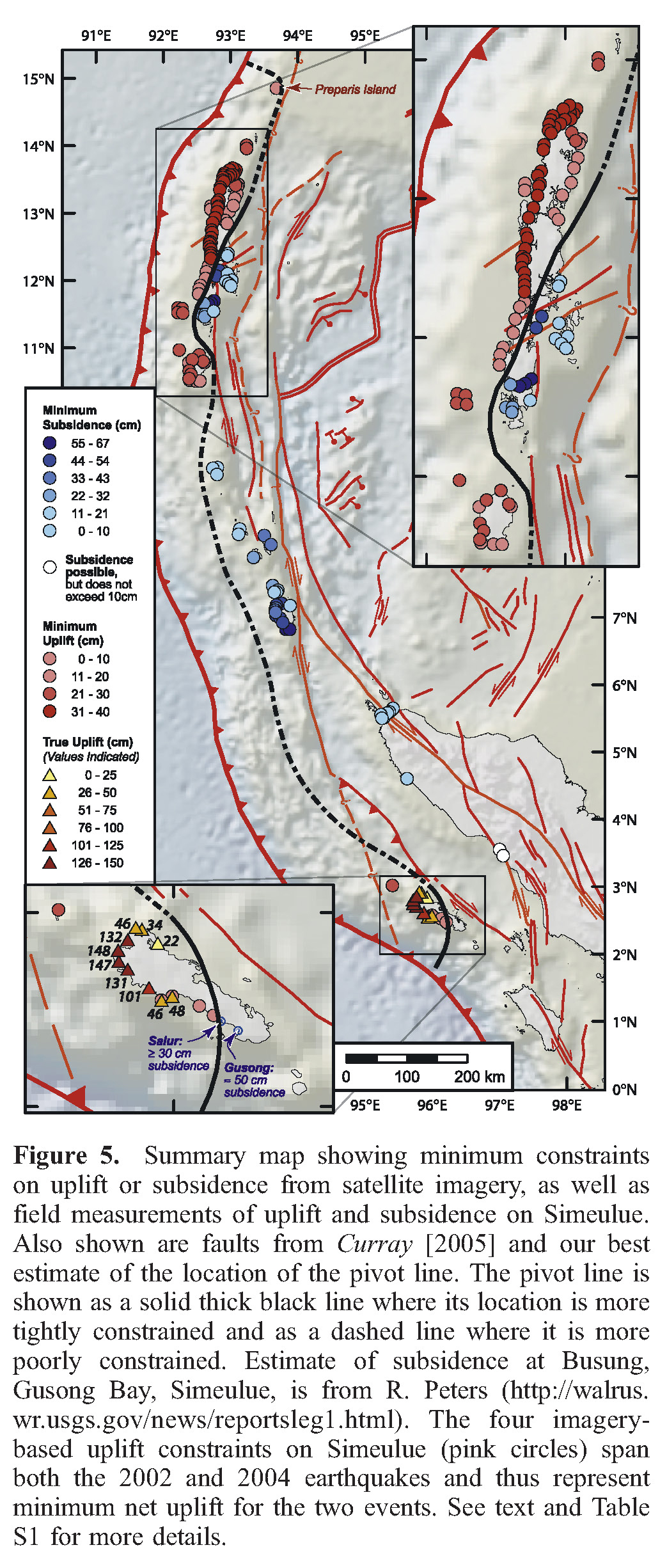
This figure from Meltzner et al. (2010) shows measurements of vertical deformation collected from coral microatolls (which are sensitive to the tides, basically, they cannot survive above a certain level of tidal elevation. Read his and related papers to learn more about this method.). These are observations that are independent of GPS data. I include this figure because it shows the complicated tectonic setting. Note all the different strike-slip and extensional faulting north of Sumatra. These faults are from Curray (2005).
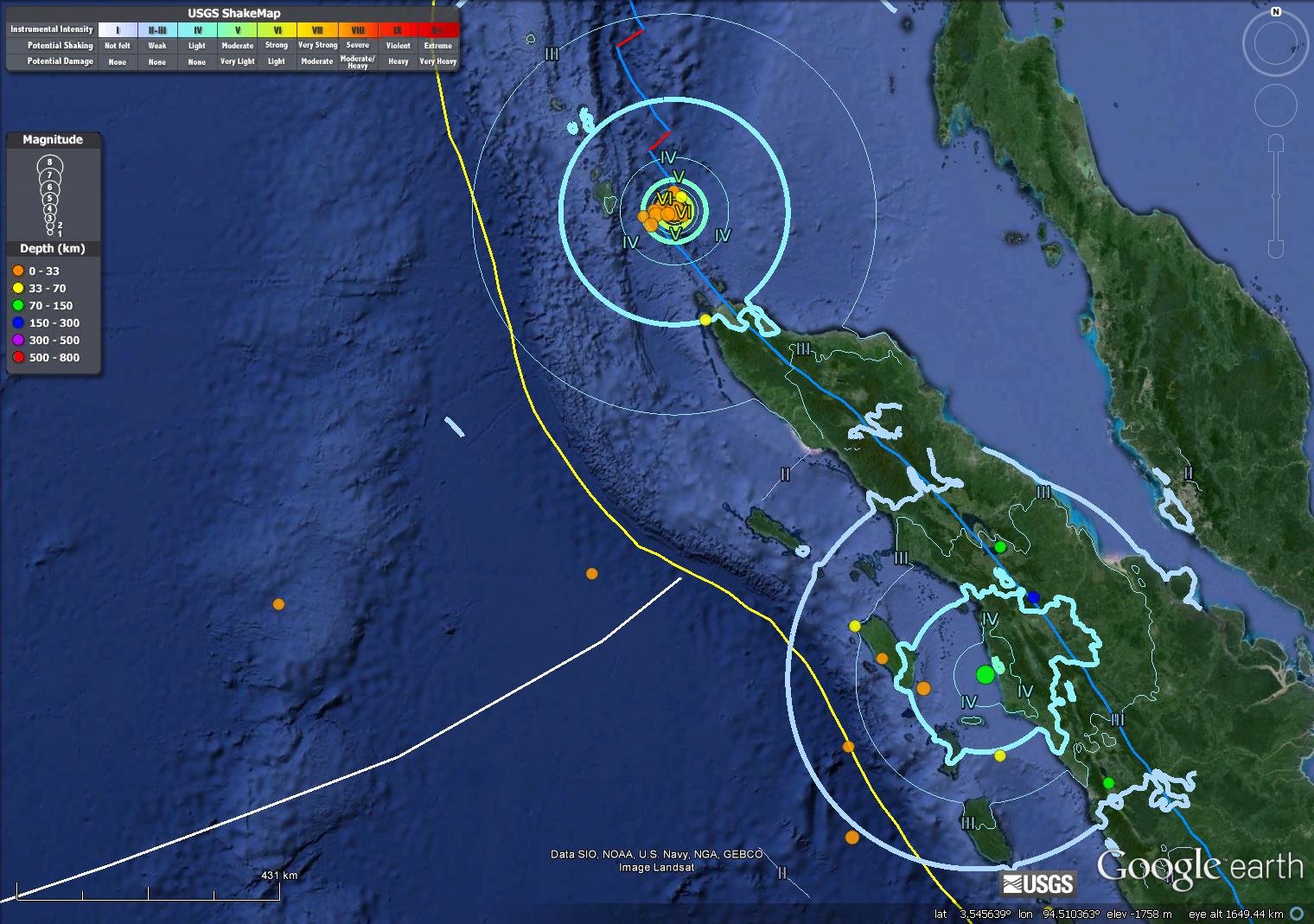
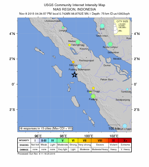
Here is a map where I plot the USGS Modified Mercalli Intensity (MMI) contours for these two M 6.4 and 6.1 earthquakes. These are estimates of ground shaking based upon Ground Motion Prediction Equations, empirical relations between shaking intensity and distance to the earthquake.
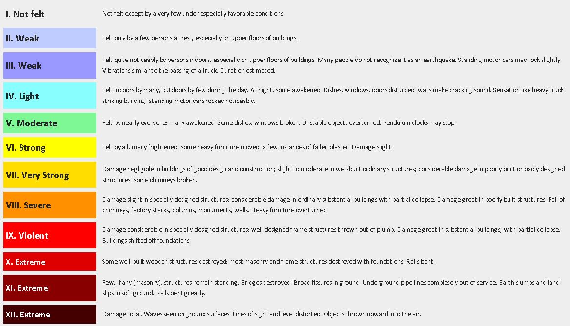
Here is one example of the MMI scale from the wiki site.
-
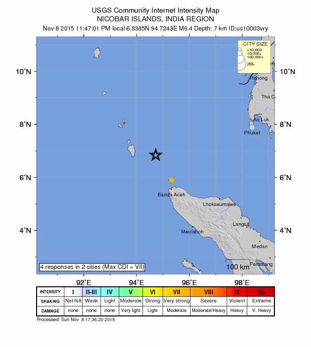
These are the two “Did You Feel It?” (DYFI) maps for these two earthquakes. The DYFI maps are based on real observations, not models. Compare these maps with the above MMI Contour map.
- M 6.4 strike-slip
- M 6.1 normal
-
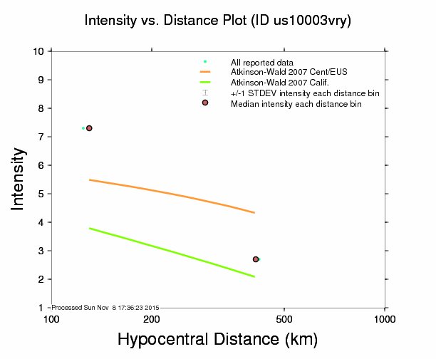
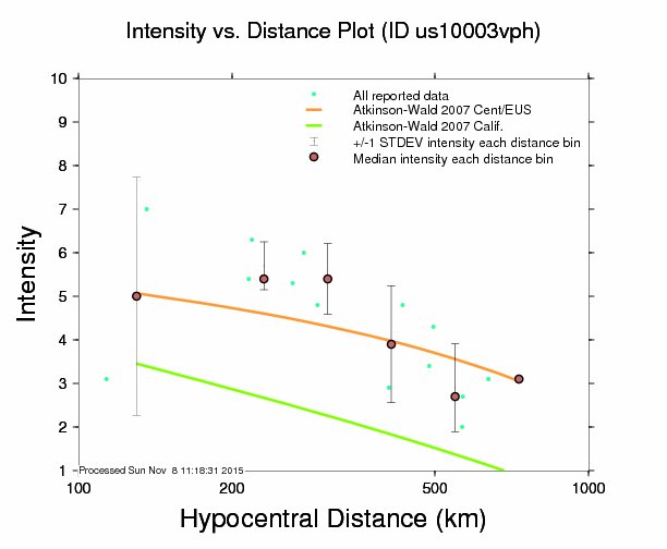
Here are the attenuation plots comparing the DYFI and MMI model based estimates of ground shaking.
- M 6.4 strike-slip
- M 6.1 normal
Here are the USGS web pages for the earthquakes I will discuss below:
- 2004.12.26 Mw 9.15
- 2005.3.28 Mw 8.6
- 2007.9.12 Me 8.5
- 2007.9.12 Mw 7.9
- 2007.9.13 Mw 7.0
- 2012.4.11 Mw 8.2
- 2012.4.11 Mw 8.6
- 2015.3.3 Mw 6.1
Here are a couple posts I put together regarding the initial instigator to this entire series of earthquakes (Mw = 9.15) and then the two largest strike slip earthquakes ever recorded (Mw = 82 and 8.6).
- Looking Back Part 1
- Looking Back Part 2
- 2012 Outer Rise Earthquakes
- Updated maps for the Outer Rise Earthquakes
Here is a map showing moment tensors for the largest earthquakes since the 26 December 2004 Mw = 9.15 Megathrust Great Sumatra-Andaman subduction zone (SASZ) earthquake. Below is a map showing the earthquake slip contours. The beginning of this series started with the Mw 9.15 and Mw = 8.7 Nias earthquakes. There were some other earthquakes along the Mentawaii patch to the south (Mw = 8.5, 7.9, and 7.0). These were also subduction zone earthquakes, but failed to release the strain that had accumulated since the last large magnitude earthquakes to have slipped in this region in 1797 and 1833. In 2012 we had two strike slip earthquakes in the outer rise, where the India-Australia plate flexes in response to the subduction. At first I interpreted these to be earthquakes on northeast striking faults since those the orientation of the predominant faulting in the region. The I-A plate has many of these N-S striking fracture zones, most notably the Investigator fracture zone (the most easterly faults shown in this map as a pair of strike slip faults that head directly for the epicenter of yesterday’s earthquake). However, considering the aftershocks and a large number of different analyses, these two earthquakes (the two largest strike slip earthquakes EVER recorded!) were deemed to have ruptured northwest striking faults. We called these off fault earthquakes, since the main structural grain is those N-S striking fracture zones. Also of note is the focal depth of these two large earthquakes (Mw 8.2 & 8.6). These earthquakes ruptured well into the mantle. Before the 2004 SASZ earthquake and the 2011 Tohoku-Oki earthquake (which also probably ruptured into the mantle), we would not have expected earthquakes in the mantle.
-
While we were at sea offshore Sumatra, there was a CBC (Canada) film maker aboard recording material for a film on Cascadia subduction zone earthquakes. This is a dity that he made for us.
- link to the embedded video below. (45 mb mp4)
- YT link to the embedded video below.
- Bilham, R., 2005. Partial and Complete Rupture of the Indo-Andaman Plate Boundary 1847 – 2004: Seismological Research Letters, v. 76, p. 299-311.
- Bock, Y., Prawirodirdjo, L., Genrich, J.F., Stevens, C.W., McCaffrey, R., Subarya, C., Puntodewo, S.S.O., Calais, E., 2003. Crustal motion in Indonesia from Global Positioning System measurements: Journal of Geophysical Research, v. 108, no. B8, 2367, doi: 10.1029/2001JB000324.
- Curray, J. R., 2005. Tectonics and history of the Andaman Sea region, J. Asian Earth Sci., 25, 187–232, doi:10.1016/j.jseaes.2004.09.001.
- Chlieh, M., Avouac, J.-P., Hjorleifsdottir, V., Song, T.-R.A., Ji, C., Sieh, K., Sladen, A., Hebert, H., Prawirodirdjo, L., Bock, Y., Galetzka, J., 2007. Coseismic Slip and Afterslip of the Great (Mw 9.15) Sumatra-Andaman Earthquake of 2004. Bulletin of the Seismological Society of America 97, S152-S173.
- Chlieh, M., Avouac, J.P., Sieh, K., Natawidjaja, D.H., Galetzka, J., 2008. Heterogeneous coupling of the Sumatran megathrust constrained by geodetic and paleogeodetic measurements: Journal of Geophysical Research, v. 113, B05305, doi: 10.1029/2007JB004981.
- Graindorge , D., Klingelhoefer, F., Sibuet, J.-C., McNeill , L., Henstock, T.J., Dean, S., Gutscher, M.-A., Dessa, J.X., Permana, H., Singh, S.C., Leau, H., White, N., Carton, H., Malod, J.A., Rangin, C., Aryawan, K.G., Chaubey, A.K., Chauhan, A., Galih, D.R., Greenroyd, C.J., Laesanpura, A., Prihantono, J., Royle, G., Shankar, U., 2008. Impact of lower plate structure on upper plate deformation at the NW Sumatran convergent margin from seafloor morphology: Earth and Planetary Science Letters, v. 275, p. 201-210.
- Hayes, G. P., D. J. Wald, and R. L. Johnson (2012), Slab1.0: A three-dimensional model of global subduction zone geometries, J. Geophys. Res., 117, B01302, doi:10.1029/2011JB008524.
- Ishii, M., Shearer, P.M., Houston, H., Vidale, J.E., 2005. Extent, duration and speed of the 2004 Sumatra-Andaman earthquake imaged by the Hi-Net array. Nature 435, 933.
- Malik, J.N., Shishikura, M., Echigo, T., Ikeda, Y., Satake, K., Kayanne, H., Sawai, Y., Murty, C.V.R., Dikshit, D., 2011. Geologic evidence for two pre-2004 earthquakes during recent centuries near Port Blair, South Andaman Island, India: Geology, v. 39, p. 559-562.
- Meltzner, A.J., Sieh, K., Chiang, H., Shen, C., Suwargadi, B.W., Natawidjaja, D.H., Philobosian, B., Briggs, R.W., Galetzka, J., 2010. Coral evidence for earthquake recurrence and an A.D. 1390–1455 cluster at the south end of the 2004 Aceh–Andaman rupture. Journal of Geophysical Research 115, 1-46.
- Patton, J.R., Goldfinger, C., Morey, A.E., Ikehara, K., Romsos, C., Stoner, J., Djadjadihardja, Y., Udrekh, Ardhyastuti, S., Gaffar, E.Z., and Vizcaino, A., 2015. A 6500 year earthquake history in the region of the 2004 Sumatra-Andaman subduction zone earthquake: Geosphere, v. 11, no. 6, p. 1–62, doi:10.1130/GES01066.1.
- Prawirodirdjo, P., McCaffrey,R., Chadwell, D., Bock, Y, and Subarya, C., 2010. Geodetic observations of an earthquake cycle at the Sumatra subduction zone: Role of interseismic strain segmentation, JOURNAL OF GEOPHYSICAL RESEARCH, v. 115, B03414, doi:10.1029/2008JB006139
- Singh, S.C., Carton, H.L., Tapponnier, P, Hananto, N.D., Chauhan, A.P.S., Hartoyo, D., Bayly, M., Moeljopranoto, S., Bunting, T., Christie, P., Lubis, H., and Martin, J., 2008. Seismic evidence for broken oceanic crust in the 2004 Sumatra earthquake epicentral region, Nature Geoscience, v. 1, pp. 5.
- Smith, W.H.F., Sandwell, D.T., 1997. Global seafloor topography from satellite altimetry and ship depth soundings: Science, v. 277, p. 1,957-1,962.
- Subarya, C., Chlieh, M., Prawirodirdjo, L., Avouac, J., Bock, Y., Sieh, K., Meltzner, A.J., Natawidjaja, D.H., McCaffrey, R., 2006. Plate-boundary deformation associated with the great Sumatra–Andaman earthquake: Nature, v. 440, p. 46-51.
- Stow, D.A.V., et al., 1990. Sediment facies and processes on the distal Bengal Fan, Leg 116, ODP Texas & M University College Station; UK distributors IPOD Committee NERC Swindon, p. 377-396.
- Tolstoy, M., Bohnenstiehl, D.R., 2006. Hydroacoustic contributions to understanding the December 26th 2004 great Sumatra–Andaman Earthquake. Survey of Geophysics 27, 633-646.
-
References:
3 thoughts on “Earthquake Report: Nicobar Isles and Sumatra!”