Over the past day or so, there has been a swarm of seismicity in the La Pine area. La Pine is on the east side of the Cascade mountain range, a magmatic arc related to the Cascadia subduction zone. As the downgoing Juan de Fuca plate extends into the upper mantle, the sea water stored in the oceanic crust (which formed under water) combines with the increased heat to melt. This melt is less dense than the crust and surrounding mantle material, so it rises. This rising magma gives rise to the volcanoes in the Cascade range. There exist every type of volcano in the Cascades due to the wide range of magma composition along the arc.
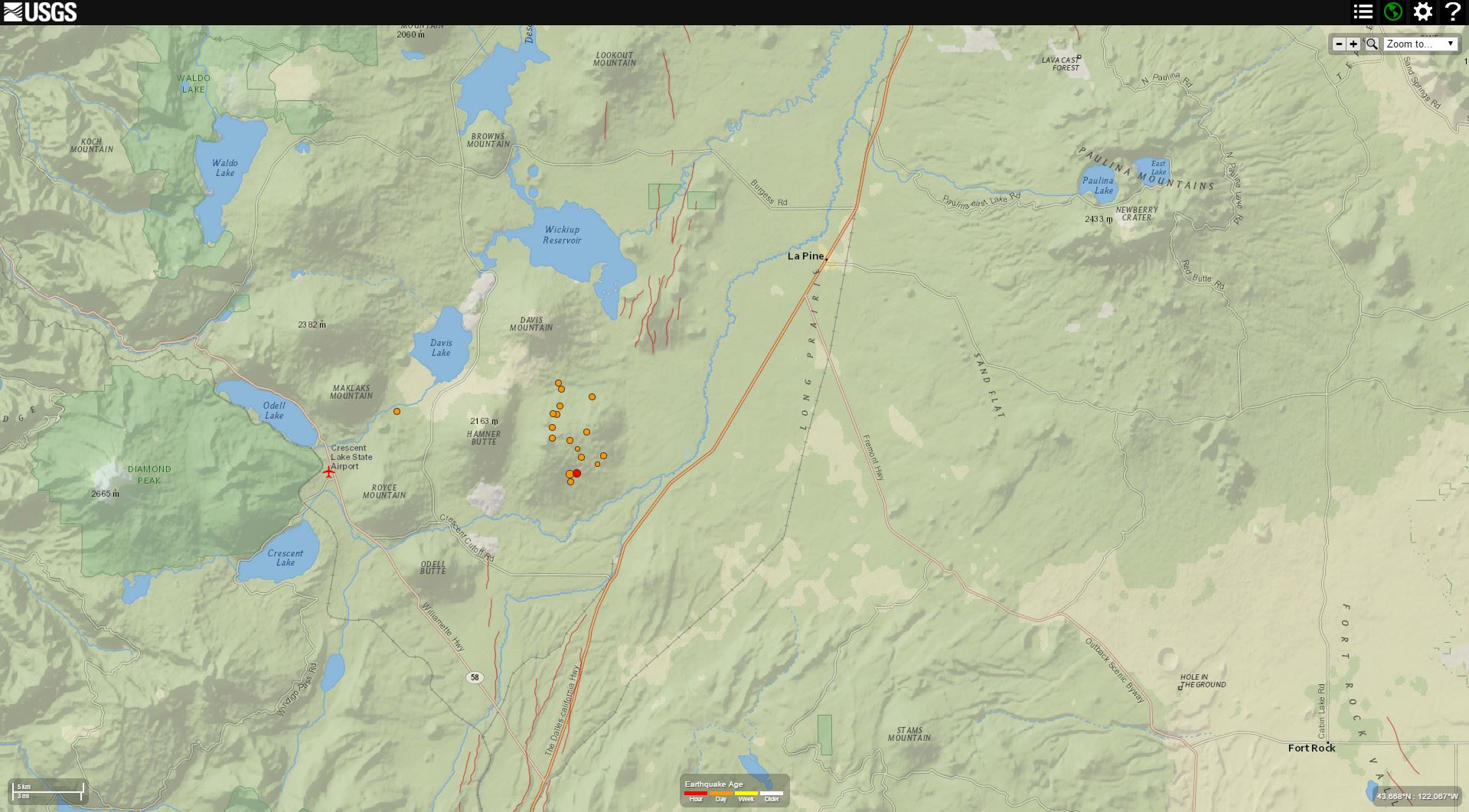
Today’s largest magnitude earthquake has a magnitude M = 3.0. This is too small to get a moment tensor or focal mechanism calculated, so we do not know what type of earthquake this is. However, we can surmise that it is either compressional or extensional, probably not shear (strike-slip). The swarm may be related to back arc extension, or may be related to some magmatic processes. I favor the former since these earthquakes plot between a series of mapped Quaternary active faults. To the west is Hamner Butte and the the north is Davis Mountain. To the north, there does appear to be some north-northeast lineaments that suggest some fault related volcanism. To the south there also are mapped faults called the Chemult graben fault system (see Personius references below). These are normal faults, so the likely mechanism for earthquakes in this swarm is extensional. The last activity on these faults predate the Mazama ash since they are overlain by a pyroclastic flow from that eruption. The latest age estimate for the eruption of Mt. Mazama is based on Bayesian modeling of many radiocarbon age determinations by Egan et al. (2015) and set at 7682–7584 cal. yr BP (95.4% probability range). However, Pezzopane (1993) classify this fault system as late Pleistocene.
Here is the USGS web page for this M = 3.0 earthquake. In addition to the compilation from Personius (see below), work has been done on the faulting in this region by Pezzopane (1993) and Pezzopane and Weldon (1993). Weldon et al. (2003) map most of the faults in this region as late Quaternary (<780 ka) in age.
This is a map that shows the locality for this mini swarm.

This is a map that shows the region, that extends across the Cascades.

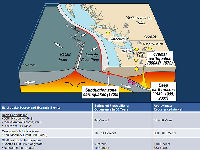
This is a map of the Cascdia subduction zone and Cascade magmatic arc.

Here is a view of the subduction zone showing the landscape and the plate configuration within the Earth. The cross section is located near the southern Willamette Valley. This is schematic and does not completely match the real geography. Note how the downgoing plate melts and the rising magma leads to volcanism of the Cascade volcanoes (a volcanic arc).

Dr. John Vidale, from the Pacific Northwest Seismic Network posted this today showing the seismic record of these earthquakes.

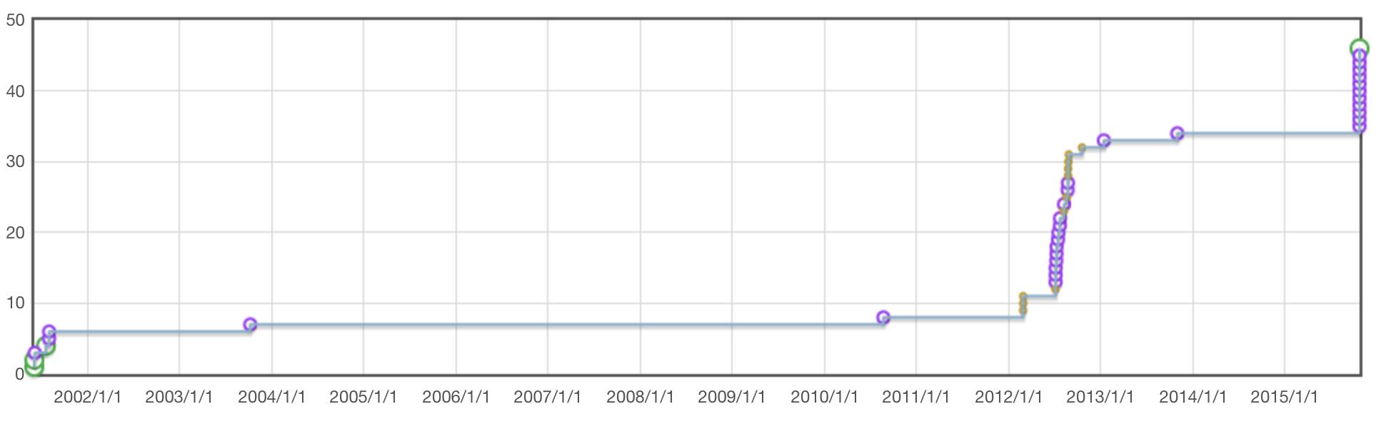
Dr. Vidale also plotted the cumulative number of earthquakes in this region for the past 12 years.
This area is at the western boundary of the High Lava Plains, where they meet the Cascades. Newberry Crater, which is where the 2000 Pacific Northwest Cell Friends of the Pleistocene field trip met, is to the northeast of this swarm. Here is a map that shows the volcanism of the region from Meigs et al. (2009). Below is the caption from Meigs et al. (2009).

Volcanic and tectonic elements of the western United States: (A) Distribution of volcanic rocks younger than 17 Ma, by age and composition (Luedke and Smith, 1984), illustrates the tremendous volcanic activity east of the Cascade Range in the northern extent of the Basin and Range province. (B) Some tectonic elements (after Jordan et al., 2004) superimposed on the map of Luedke and Smith (1984). Solid brown line outlines the Basin and Range province. Volcanic fields younger than 5 Ma illustrate the continuing activity in the Cascade Range and along the High Lava Plains (HLP; brown field) and the eastern Snake River Plain (ESRP). Short curves along the HLP and ESRP are isochrons (ages in Ma) for the migrating silicic volcanism along each volcanic trace. Flood basalt activity was fed from dike systems in the northern Nevada rift (NNR), Steens Mountain (SM), the western Snake River Plain (WSRP) and the Chief Joseph (CJ) and Cornucopia (C) dike swarms of the Columbia River Basalt Group. These dikes occur near the western border of Precambrian North America as defined by the 87Sr/86Sr 0.706 line (large dot-dash line). Northwest-trending fault systems—Olympic-Wallowa lineament (OWL), Vale (V), Brothers (B), Eugene-Denio (ED) and McLoughlin (Mc)—are shown by the short-dashed lines. Additional features include Newberry Volcano (NB), Owyhee Plateau (OP), Juan de Fuca Plate, San Andreas fault zone (SAFZ), and Mendocino triple junction (MTJ).CA—California; ID—Idaho; OR—Oregon; NV—Nevada; UT— Utah; WA—Washington; WY—Wyoming.
Here is the Weldon et al. (2002) map of faults in this region.

-
References:
- Chaytor, J.D., Goldfinger, C., Dziak, R.P., and Fox, C.G., 2004. Active deformation of the Gorda plate: Constraining deformation models with new geophysical data in Geology, v. 32, p. 353-356
- Egan, J., Staff, R., and Blackford, J., 2015. A high-precision age estimate of the Holocene Plinian eruption of Mount Mazama, Oregon, USA in The Holocene
- Meigs, A., Scarberry, K., Grunder, A., Carlson, R., Ford, M.T., Fouch, M., Grove, T., Hart, W.K., Iademarco, M., Jordan, B., Milliard, J., Streck, M.J., Trench, D., and Weldon, R., 2009. Geological and geophysical perspectives on the magmatic and tectonic development, High Lava Plains and northwest Basin and Range, in O’Connor, J.E., Dorsey, R.J., and Madin, I.P., eds., Volcanoes to Vineyards: Geologic Field Trips through the Dynamic Landscape of the Pacific Northwest: Geological Society of America Field Guide 15, p. 435–470, doi: 10.1130/2009.fl d015(21).
- Nelson, A.R., Kelsey, H.M., Witter, R.C., 2006. Great earthquakes of variable magnitude at the Cascadia subduction zone in Quaternary Research 65, 354-365.
- Personius, S.F., compiler, 2002. Fault number 839a, Chemult graben fault system, western section, in Quaternary fault and fold database of the United States: U.S. Geological Survey website, http://earthquakes.usgs.gov/hazards/qfaults, accessed 10/22/2015 10:08 PM.
- Personius, S.F., compiler, 2002. Fault number 839b, Chemult graben fault system, Walker Rim section, in Quaternary fault and fold database of the United States: U.S. Geological Survey website, http://earthquakes.usgs.gov/hazards/qfaults, accessed 10/22/2015 10:09 PM.
- Pezzopane, S.K., 1993, Active faults and earthquake ground motions in Oregon: Eugene, Oregon, University of Oregon, unpublished Ph.D. dissertation, 208 p.
- Pezzopane, S.K. and Weldon, R.J.III., 1993. Tectonic Role of Active Faulting in Central Oregon in Tectonics, v. 12, no. 5, p. 1140-1169.
- Weldon, R.J., Fletcher, D.K., Weldon, E.M., Scharer, K.M., and McCrory, P.A., 2003. An update of Quaternary faults of central and eastern Oregon: U.S. Geological Survey Open-File Report 02-301 (CD-ROM), 26 sheets, scale 1:100,000