Today we had a small earthquake in the Andaman Sea, west of Thailand and east of the Andaman Isles (India).
The Andaman Sea is a region of backarc spreading and connects the Sumatra fault (a (strike-slip) sliver fault that accommodates oblique motion on the Sunda subduction zone offshore of Sumatra and the Andaman/Nicobar Islands), with the strike-slip Sagaing fault in Myanmar/Burma. I have two pages that discuss the historic subduction zone earthquakes along the Sunda subduction zone. The first page covers the 2004 earthquake in general. The second page discusses various measures of energy released during the 2004 earthquake.
-
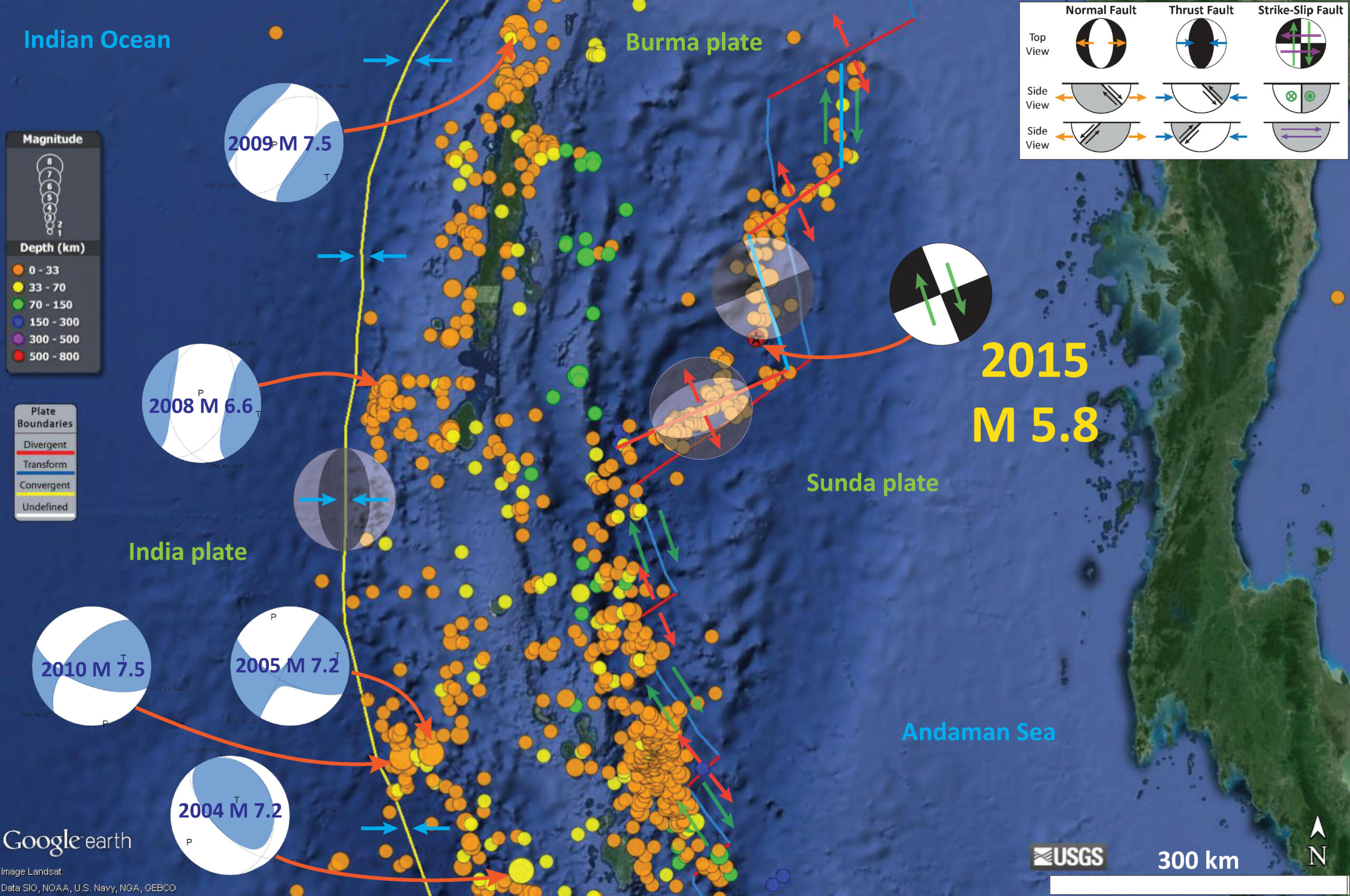
Here are the USGS web pages for the earthquakes displayed on the map below.
- 1971.03.28 M 6.3 (not labeled on map, but very near to the M 5.8 from 2015)
- 2004.12.26 M 7.2
- 2005.07.24 M 7.2
- 2008.06.27 M 6.6
- 2009.08.10 M 7.5
- 2010.06.12 M 7.5
- 2015.07.03 M 5.8
Below is a map of the region. The M 5.8 did not have a moment tensor nor focal mechanism calculated, but I placed a generic strike-slip focal mechanism in an orientation that aligns with transform plate boundary that likely ruptured during this earthquake. The M 5.8 epicenter is depicted by a red and black star. I pose that this was a right-lateral strike slip earthquake along a transform plate boundary (shown in blue). Note that I have also added updated fault locations in this area, based upon seismicity (the USGS located plate boundaries are not quite correct; mine are imperfect too, but are consistent with the seismicity). The USGS fault lines have a stepped appearance and the ones that I drew look more smooth.
I placed moment tensors for some of the largest earthquakes in this region. The 2009 and 2008 earthquakes in the northwest are extensional, so are probably in the downgoing India plate (extension from bending of the plate or slab pull). The 2010 and 2005 earthquakes in the southwest are strike-slip and may be due to the oblique subduction (strain partitioning). There is a legend that shows how moment tensors can be interpreted. Moment tensors are graphical solutions of seismic data that show two possible fault plane solutions. One must use local tectonics, along with other data, to be able to interpret which of the two possible solutions is correct. The legend shows how these two solutions are oriented for each example (Normal/Extensional, Thrust/Compressional, and Strike-Slip/Shear). There is more about moment tensors and focal mechanisms at the USGS.

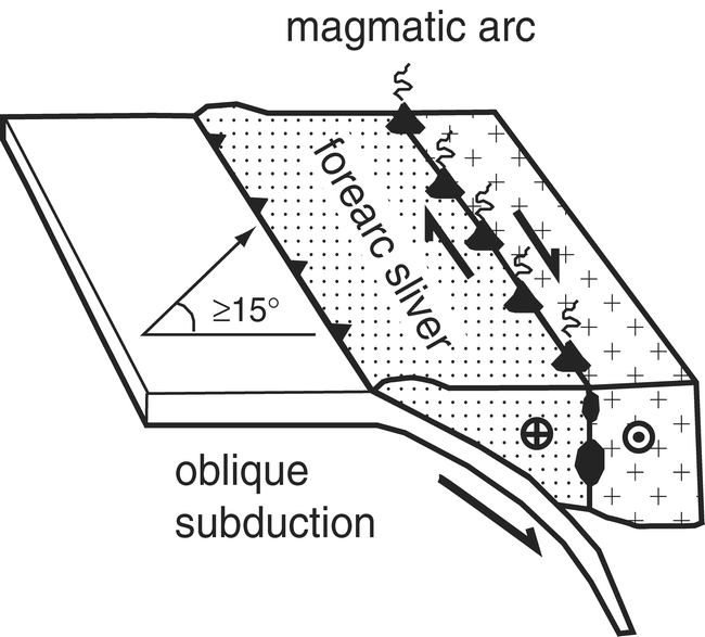
Here is a graphic that depicts how a sliver fault accommodates the strain partitioning from oblique subduction.
This is a general plate tectonic map of the region from Subarya et al. (2006). The Sumatra fault is the right-lateral strike-slip fault that rips through the center of the Island of Sumatra. The Sagaing fault is the right-lateral strike-slip fault extending into Myanmar/Burma north of the Andaman Sea. The purple arrows show the plate motion related to the oceanic spreading ridges in the Andaman Sea.

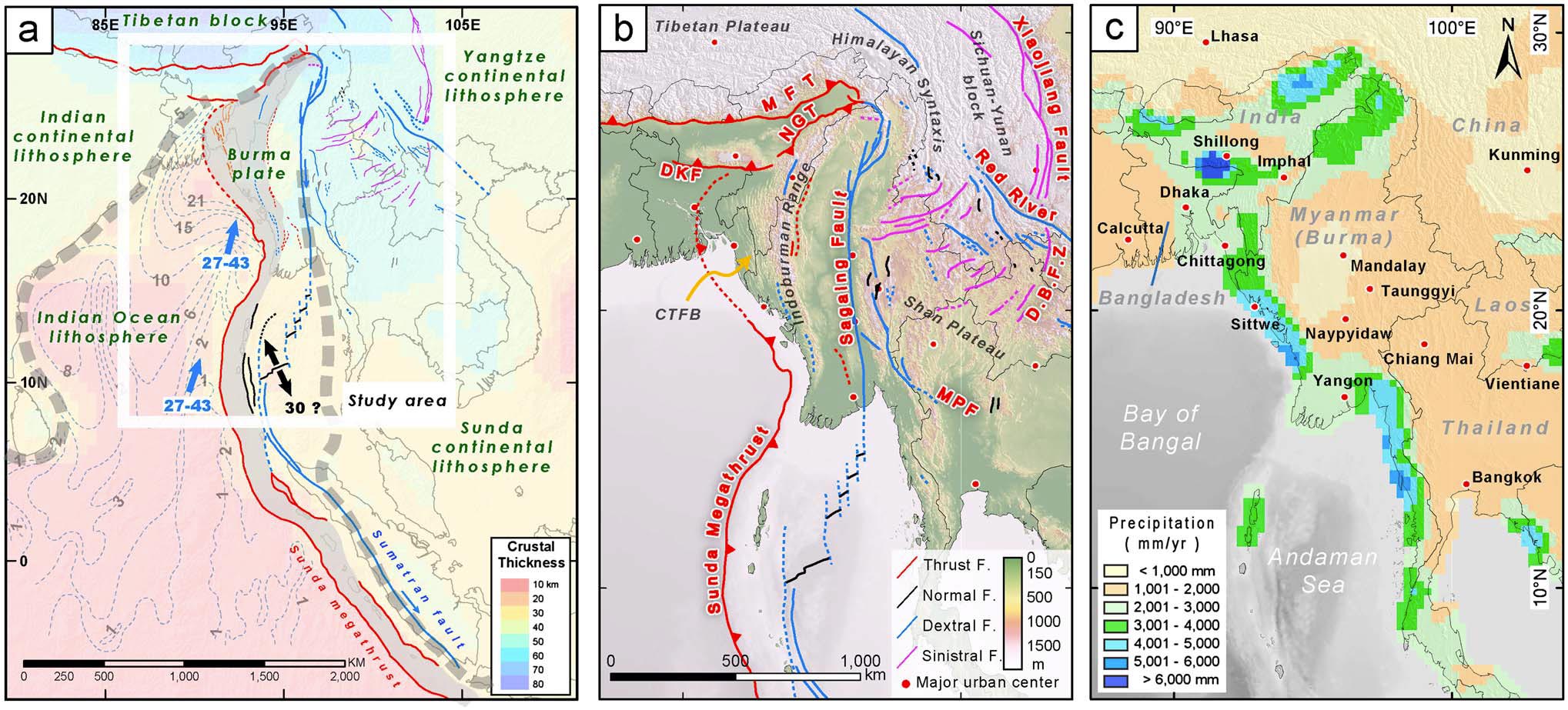
This map shows how the Sunda subduction zone and Sagaing fault extend into Asia (Wang et al., 2012). This figure was later modified and included in Wang et al. (2014). Click on the map to see it at a larger scale.

Here is a figure from Wang et al. (2014) that incorporates both the preceding maps. Below is the text that goes along with this figure (from the original Wang document). Click on the map to see it at a larger scale.
Major tectonic elements of the Myanmar region and the extreme variation in rainfall that influence the preservation of tectonic landforms. (a) Crustal thickness associated with the major plates and tectonic blocks of the region. The blue arrow shows the direction of Indian plate motion relative to Sunda plate [e.g., Socquet et al., 2006]. The black arrow shows the opening direction of the Central Andaman spreading center. The velocity is in mm/yr. (b) Two major fault systems accommodate the northward translation of the Indian plate into Eurasia. These are the northern extension of the Sunda megathrust and the Sagaing fault system, which form the western and eastern margin of the Burma Plate. Conjugate right- and left-lateral faults of the Shan plateau and southern China accommodate southwestward extrusion of the Sichuan-Yunnan block around the eastern Himalayan syntaxis. (c) Extreme variations in annual rainfall across the region result in extreme variations in preservation of tectonic landforms. The precipitation data are from GPCC global data [Rudolf and Schneider, 2005].
Here is an animation showing seismicity in this region from 1970 through July 3, 2015. The largest earthquakes (magnitude greater than 6.0) are plotted as grey circles. Note how there is a large increase in seismicity associated with the 2004 Sumatra Andaman subduction zone earthquake. There is also a swarm of activity associated with the outer rise earthquakes (the largest strike-slip earthquakes ever recorded on a seismograph).
-
References:
- Rudolf, B., and U. Schneider, 2005. Calculation of gridded precipitation data for the global land-surface using in-situ gauge observations,
paper presented at Proceedings of the 2nd Workshop of the International Precipitation Working Group IPWG. - Subarya, C., Chlieh, M., Prawirodirdjo, L., Avouac, J., Bock, Y., Sieh, K., Meltzner, A.J., Natawidjaja, D.H., McCaffrey, R., 2006. Plate-boundary deformation associated with the great Sumatra–Andaman earthquake: Nature, v. 440, p. 46-51.
- Socquet, A., C. Vigny, N. Chamot-Rooke, W. Simons, C. Rangin, and B. Ambrosius (2006), India and Sunda plates motion and deformation along their boundary in Myanmar determined by GPS, J. Geophys. Res., 111, B05406, doi:10.1029/2005JB003877.
- Wang, Y., K. Sieh, S. T. Tun, K.-Y. Lai, and T. Myint, 2014. Active tectonics and earthquake potential of the Myanmar region, J. Geophys. Res. Solid Earth, 119, 3767–3822, doi:10.1002/2013JB010762.
4 thoughts on “Andaman Sea Earthquake!”