- 2019-05-26 07:41:14 (UTC)
- 5.796°S 75.298°W
- 109.9 km depth
Interactive Map 
Regional Information Felt Report - Tell Us! 001585Responses Contribute to citizen science. Please tell us about your experience.
- Did You Feel It?
IXmmi 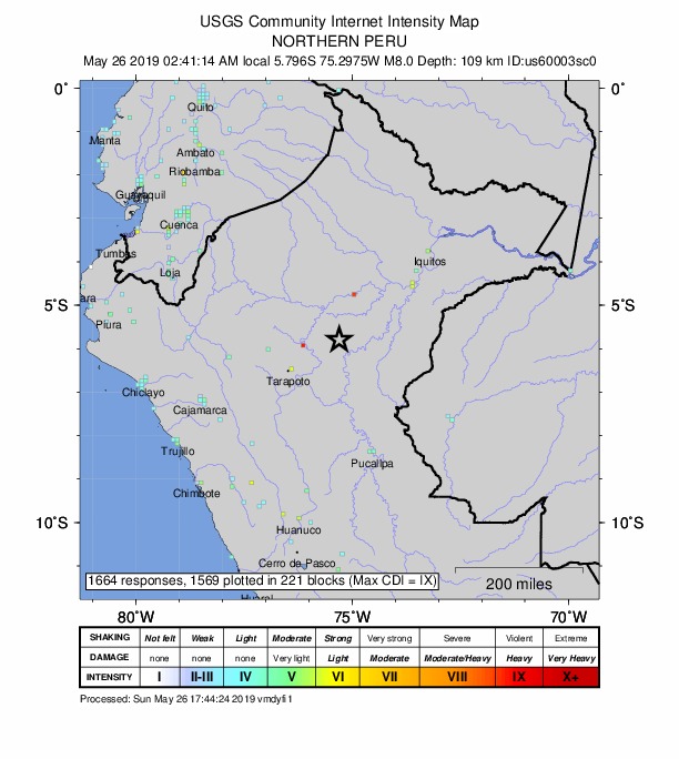
Community Internet Intensity Map - ShakeMap
VIIImmi 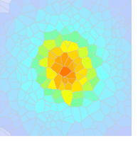
Estimated Intensity Map - PAGER
ORANGE 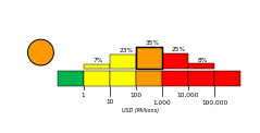
Estimated Economic Losses 
Estimated Fatalities Ground Failure - Landslides
Limited area affected
Little or no population exposed
- Liquefaction
Extensive area affected
Significant population exposed
Origin - Review Status
- REVIEWED
- Magnitude
- 8.0 mww
- Depth
- 109.9 km
- Time
- 2019-05-26 07:41:14 UTC
Moment Tensor Fault Plane Solution Finite Fault 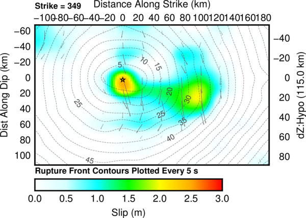
Cross-section of slip distribution. Tsunami 
U.S. Tsunami Warning System To view any current tsunami advisories for this and other events please visit https://www.tsunami.gov.
View Nearby Seismicity - Time Range

± Three Weeks - Search Radius

250.0 km - Magnitude Range

≥ 5.0
Tectonic Summary
The May 26, 2019, M 8.0 northern Peru earthquake occurred as the result of normal faulting at an intermediate depth, approximately 110 km beneath the Earth's surface within the subducted lithosphere of the Nazca plate. Focal mechanism solutions indicate that rupture occurred on either a north- or south-striking, moderately dipping normal fault. At the location of the earthquake, the Nazca plate moves to the east relative to the South America plate at a velocity of about 70 mm/yr, subducting at the Peru-Chile Trench, to the west of the Peruvian coast and the May 26th earthquake. Earthquakes of northern Peru and most of western South America are due to strains generated by this ongoing subduction; at this latitude, the Nazca plate is seismically active to depths of about 650 km. This earthquake occurred in a segment of the subducted plate that has produced frequent earthquakes with focal depths of 100 to 150 km.
Earthquakes like this event, with focal depths between 70 and 300 km, are commonly termed “intermediate-depth” earthquakes. Intermediate-depth earthquakes represent deformation within subducted slabs rather than at the shallow plate interface between subducting and overriding tectonic plates. They typically cause less damage on the ground surface above their foci than is the case with similar-magnitude shallow-focus earthquakes, but large intermediate-depth earthquakes may be felt at great distance from their epicenters.
While commonly plotted as points on maps, earthquakes of this size are more appropriately described as slip over a larger fault area. Normal events of the size of the May 26, 2019 M 8.0 earthquake are typically about 180x50 km (length x width).
Large intermediate-depth earthquakes are reasonably common in this section of the Nazca slab, and three other intermediate-depth M 7+ events have occurred within 250 km of the September 26th earthquake over the past three decades. A M 7.5 earthquake in September 2005, located at a similar depth but approximately 130 km to the west of the May 26th, 2019 earthquake, caused 5 deaths, about 70 injuries, and significant damage in the surrounding region.