- 2018-10-25 22:54:51 (UTC)
- 37.478°N 20.560°E
- 16.6 km depth
Interactive Map 
Regional Information Felt Report - Tell Us! 000160Responses Contribute to citizen science. Please tell us about your experience.
- Did You Feel It?
VIImmi 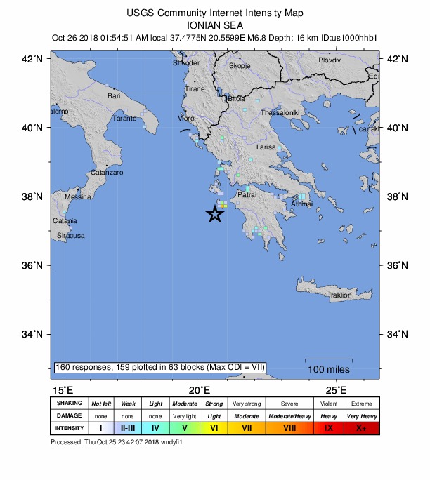
Community Internet Intensity Map - Estimated Intensity
VIImmi - Perceived Shaking
- Very strong
- Potential Damage
- Moderate
- PAGER
YELLOW 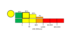
Estimated Economic Losses 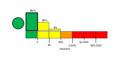
Estimated Fatalities Ground Failure - Landslides
Little or no area affected
Little or no population exposed
- Liquefaction
Limited area affected
Limited population exposed
Origin - Review Status
- REVIEWED
- Magnitude
- 6.8 mww
- Depth
- 16.6 km
- Time
- 2018-10-25 22:54:51 UTC
Moment Tensor Fault Plane Solution View Nearby Seismicity - Time Range

± Three Weeks - Search Radius

250.0 km - Magnitude Range

≥ 3.0