M 7.0 - 117km E of Kimbe, Papua New Guinea
- 2018-10-10 20:48:20 (UTC)
- 5.678°S 151.198°E
- 40.3 km depth
Interactive Map 
Regional Information Felt Report - Tell Us! 000000Responses Contribute to citizen science. Please tell us about your experience.
- Estimated Intensity
VIImmi - Perceived Shaking
- Very strong
- Potential Damage
- Moderate
- PAGER
GREEN 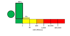
Estimated Economic Losses 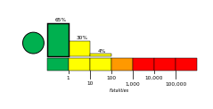
Estimated Fatalities Origin - Review Status
- REVIEWED
- Magnitude
- 7.0 mww
- Depth
- 40.3 km
- Time
- 2018-10-10 20:48:20 UTC
Moment Tensor Fault Plane Solution Tsunami 
U.S. Tsunami Warning System To view any current tsunami advisories for this and other events please visit https://www.tsunami.gov.
View Nearby Seismicity - Time Range

± Three Weeks - Search Radius

250.0 km - Magnitude Range

≥ 4.0