Jump to Navigation
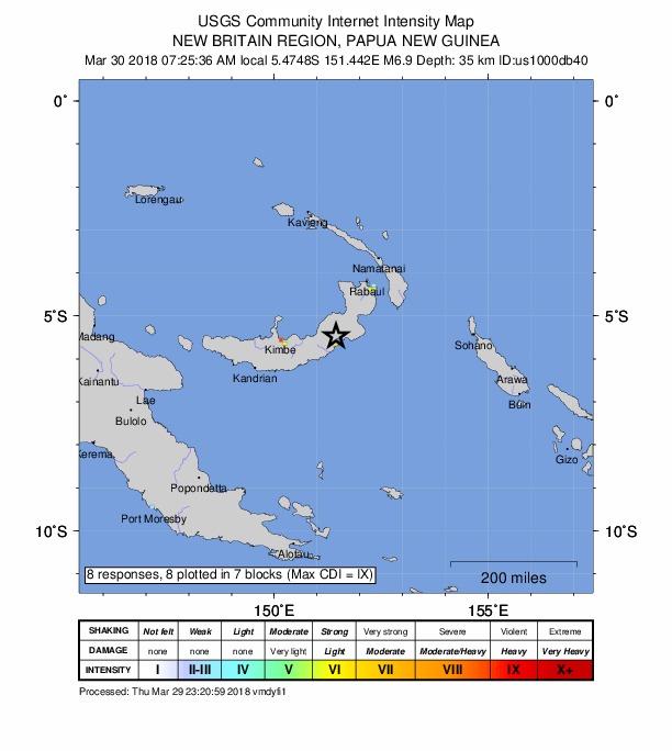
M 6.9 - 144km E of Kimbe, Papua New Guinea
2018-03-29 21:25:36 UTC
5.475°S 151.442°E
35.0 km depth
Did You Feel It?
Felt Report - Tell Us!
Back to Impact
Contributed by
US
3
last updated 2018-03-29 23:21:06 (UTC)
The data below are the most preferred data available
chevron_left
Intensity Map
ZIP Map
Intensity Vs. Distance
Responses Vs. Time
DYFI Responses
chevron_right
1 of 1
Coords: UTM:(56M 042 951 10000) Kokopo Intensity: VI Responses: 1
Coords: UTM:(56M 041 951 10000) Kokopo Intensity: VI Responses: 1
Coords: Geocoded box UTM:(56M 032 937 10000) Intensity: VI Responses: 1
Coords: UTM:(56M 019 937 10000) Kimbe Intensity: VI Responses: 1
Coords: UTM:(56M 042 952 10000) Kokopo Intensity: III Responses: 1
Coords: UTM:(55L 051 895 10000) Port Moresby Intensity: III Responses: 2
Coords: UTM:(56M 018 938 10000) Kimbe Intensity: IX Responses: 1
Latest Earthquakes
Overview
Interactive Map
Regional Information
Impact
Felt Report - Tell Us!
Did You Feel It?
ShakeMap
PAGER
Technical
Origin
Moment Tensor
Waveforms
Download Event KML
View Nearby Seismicity
Earthquakes
Hazards
Data & Products
Learn
Monitoring
Research
Search
Menu