- 2000-05-12 18:43:18 (UTC)
- 23.548°S 66.452°W
- 225.0 km depth
Interactive Map 
Regional Information Felt Report - Tell Us! 000000Responses Contribute to citizen science. Please tell us about your experience.
- ShakeMap
Vmmi 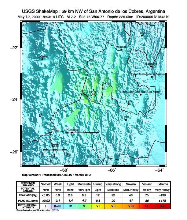
Estimated Intensity Map Origin - Review Status
- REVIEWED
- Magnitude
- 7.2 mwc
- Depth
- 225.0 km
- Time
- 2000-05-12 18:43:18 UTC
Moment Tensor Fault Plane Solution View Nearby Seismicity - Time Range

± Three Weeks - Search Radius

250.0 km - Magnitude Range

≥ 4.0
Tectonic Summary
The May 12, 2000, M 7.2 earthquake near Jujuy, Argentina occurred as the result of normal faulting at intermediate depth within the subducted Nazca plate, approximately 225 km beneath South America in northern Argentina. Focal mechanism solutions for the earthquake indicate that rupture occurred on either a near-vertical normal fault or on a very shallowly dipping oblique normal fault within the interior of the subducted Nazca slab. Slip on a fault of either orientation would accommodate the down-dip extension of the Nazca slab that is implied by the normal-component of the faulting solution. At the location of the earthquake, the Nazca plate moves eastward with respect to the South America plate, subducting at the Peru-Chile Trench west of the May 12th earthquake at a velocity of about 71 mm/yr. Earthquakes like this event, with focal depths between 70 and 300 km, are commonly termed “intermediate-depth” earthquakes. Intermediate-depth earthquakes represent deformation within subducted slabs rather than at the shallow plate interface between subducting and overriding tectonic plates. They typically cause less damage on the ground surface above their foci than is the case with similar-magnitude shallow-focus earthquakes, but large intermediate-depth earthquakes may be felt at great distance from their epicenters. “Deep-focus” earthquakes, those with focal depths greater than 300 km, also occur in the subducted Nazca plate beneath central Argentina, such as the M 7.0 earthquake that occurred to the southeast of the May 12th event earlier this year at a depth of more than 600 km. Earthquakes have been reliably located to depths greater than 600 km in this region. Over the preceding 13 years there have been three other M 6.5 or larger earthquakes within 200 km of the May 12th event, all with depths close to 200 km.
Hayes et al. (2016) Tectonic summaries of magnitude 7 and greater earthquakes from 2000 to 2015, USGS Open-File Report 2016-1192. (5.2 MB PDF)